img

官方微信

高级检索

中国沙漠 ›› 2021, Vol. 41 ›› Issue (3): 25-33.DOI: 10.7522/j.issn.1000-694X.2021.00006

• • 上一篇    下一篇

雅鲁藏布江中游江心洲、河漫滩面积及其指示的沙源特征

马鹏飞1(), 论珠群培2, 张焱3, 次仁尼玛2, 逯军峰3, 梁爱民4, 张正偲3()   

  1. 1.西藏自治区气候中心,西藏 拉萨 850000
    2.山南市气象局,西藏 山南 856000
    3.中国科学院西北生态环境资源研究院 沙漠与沙漠化重点实验室,甘肃 兰州 730000
    4.陕西师范大学,陕西 西安 710119
  • 收稿日期:2020-10-26 修回日期:2021-01-08 出版日期:2021-05-26 发布日期:2021-05-26
  • 通讯作者: 张正偲
  • 作者简介:张正偲(E-mail: zhangzhsi@lzb.ac.cn
    马鹏飞(1982—),男,山东栖霞人,高级工程师,主要从事气候与气候变化研究。E-mail: 85777975@qq.com
  • 基金资助:
    西藏自治区“十三五”重点规划项目(“雅江北岸易地扶贫搬迁区沙尘监测与预报预警系统建设”, “西藏主要地表特征科学考察及研究”,“省级生态遥感应用能力建设”);第二次青藏高原综合科学考察项目(2019QZKK0105-06)

Sand supplement characteristics indicated by the area of river inland, flood plain in the riverbed of the Yarlung Zangbo River

Pengfei Ma1(), Qunpei Lunzhu2, Yan Zhang3, Nima Ciren2, Junfeng Lu3, Aimin Liang4, Zhengcai Zhang3()   

  1. 1.Tibet Climate Center,Lhasa 850000,China
    2.Shannan Meteorological Bureau,Shannan 856000,Tibet,China
    3.Key Laboratory of Desert and Desertification,Northwest Institute of Eco-Environment and Resources,Chinese Academy of Sciences,Lanzhou 730000,China
    4.Shanxi Normal University,Xi’an 710119,China
  • Received:2020-10-26 Revised:2021-01-08 Online:2021-05-26 Published:2021-05-26
  • Contact: Zhengcai Zhang

摘要:

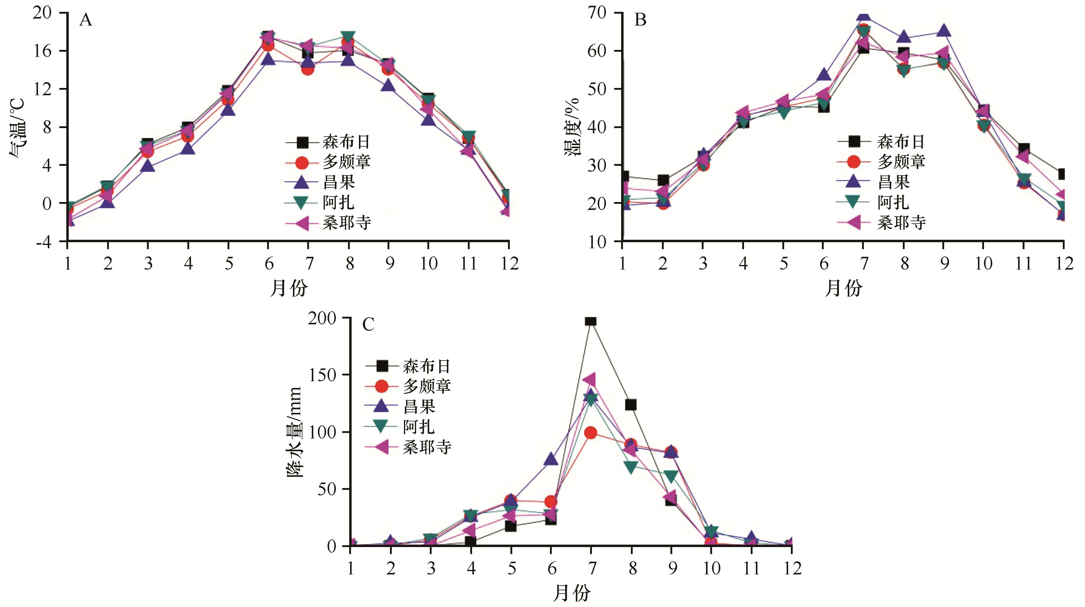
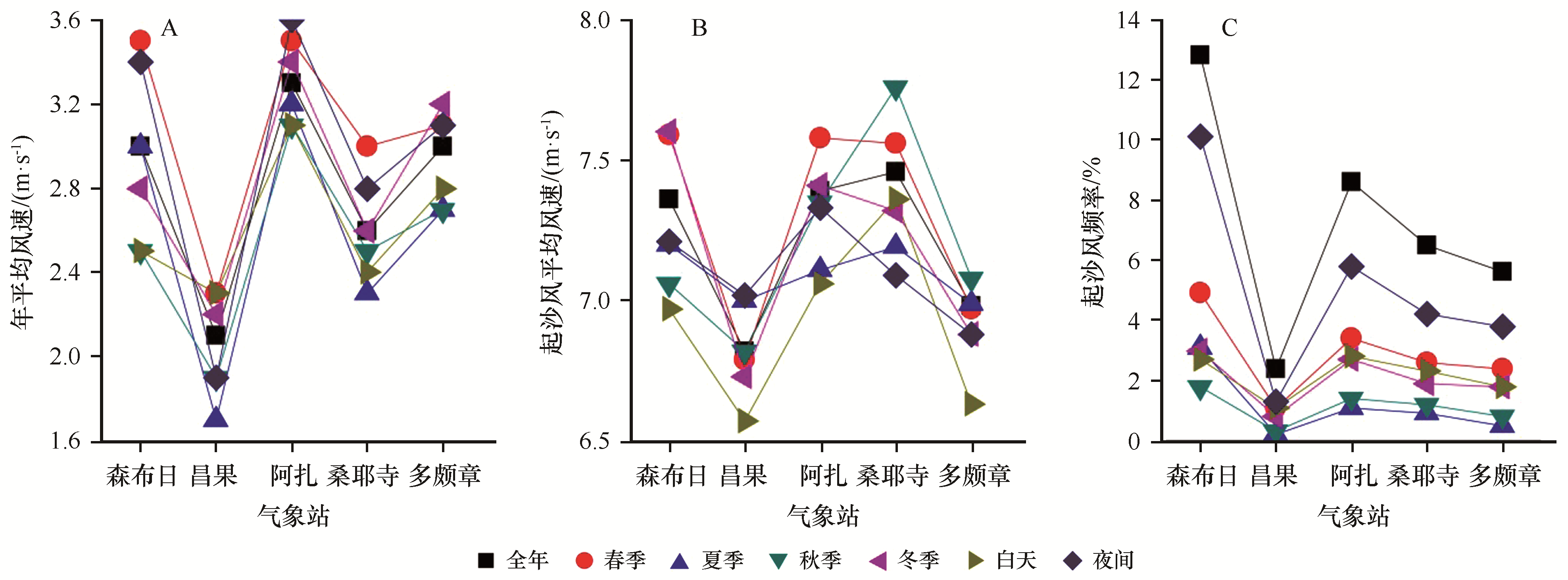
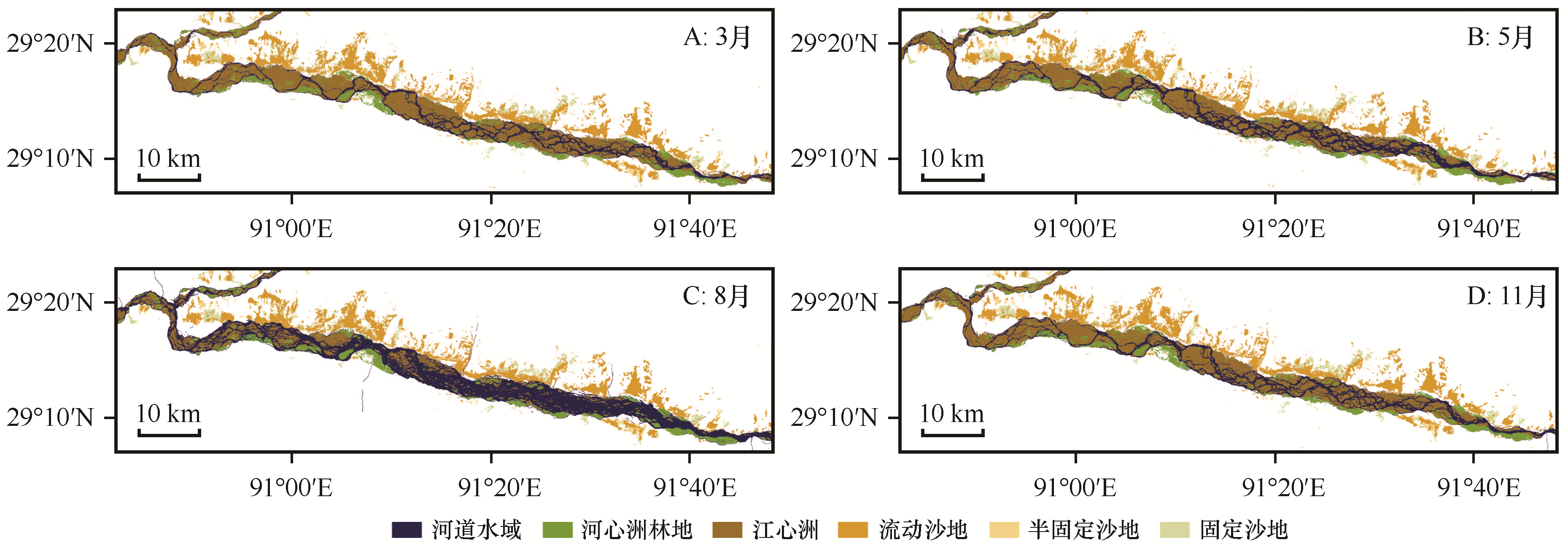
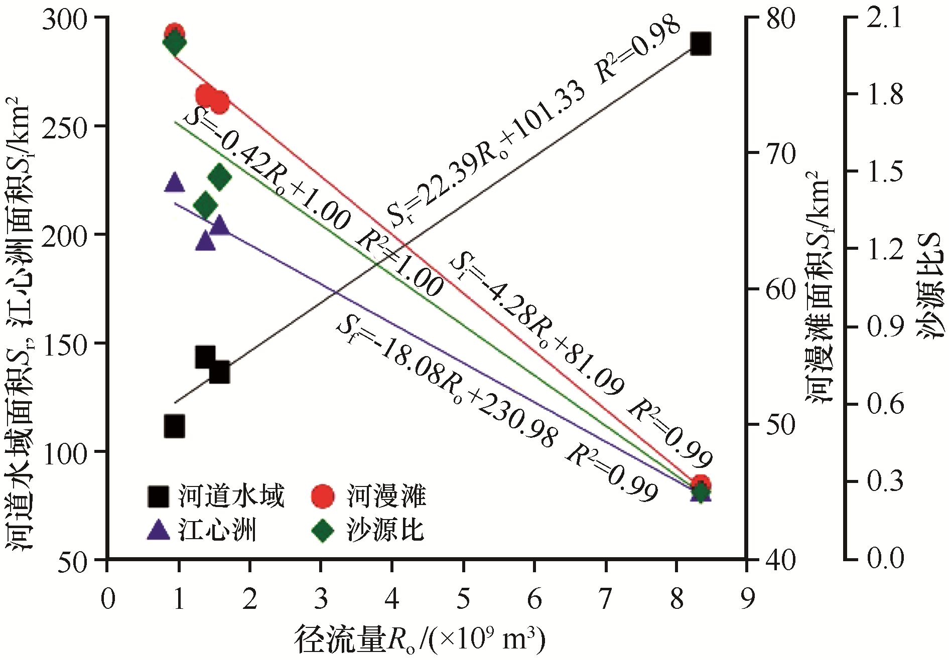
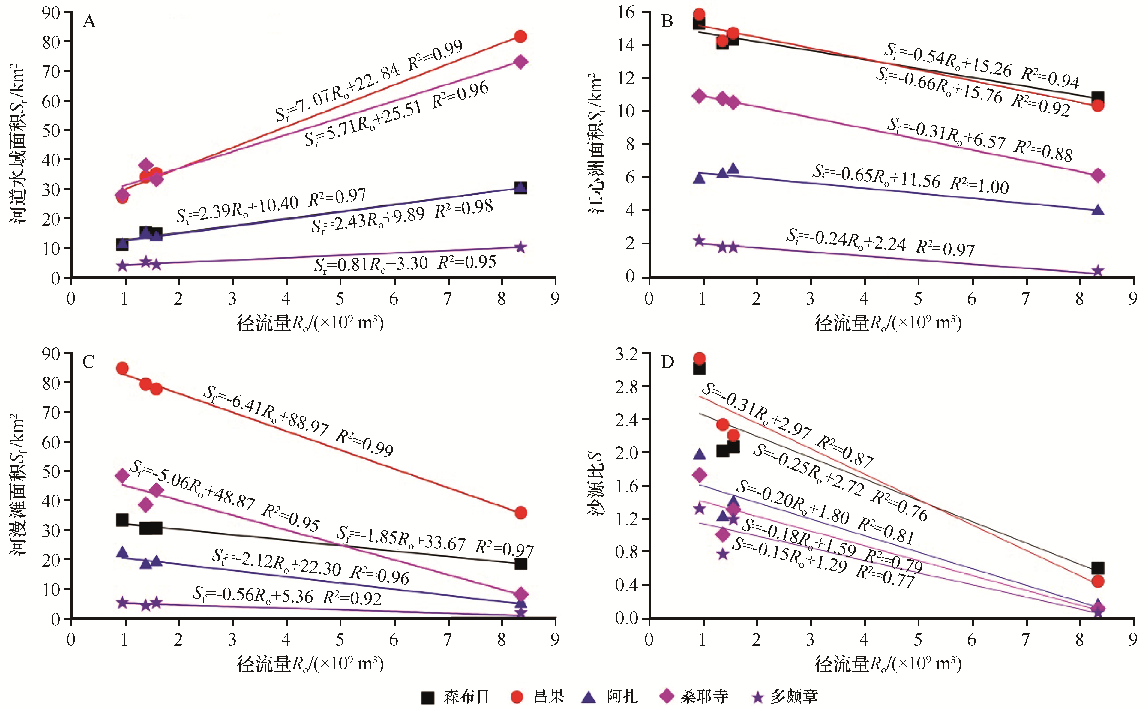
雅鲁藏布江流域中游(贡嘎县至乃东区)江心洲和河漫滩等河流地貌发育,同时也发育了不同类型的风沙地貌,是雅鲁藏布江流域风沙灾害最为严重的地区。冬春季大范围裸露的江心洲和河漫滩,为沙尘暴的发生提供沙源,也可能是北岸沙丘的物源。目前对江心洲和河漫滩面积动态变化过程及其与沙源之间的关系几乎没有研究。为此,本文通过对2019年11月至2020年8月遥感影像解译和风动力条件综合分析,探讨河床动态变化过程与沙源之间的关系。结果表明:江心洲和河漫滩面积具有明显的时空变化特征,主要受径流量的影响。江心洲面积3月最大(222.95 km2),8月最小(80.61 km2)。沙源比(河道内江心洲面积与水域面积的比值)具有明显时空变化规律,3月最大(2.00),8月最小(0.28)。河漫滩面积也具有相似的变化规律,3月78.99 km2,8月仅45.45 km2。起沙风频率冬春季大,意味着3月风沙活动强度最大,8月最小。由此可知,江心洲和河漫滩能够为研究区的风沙灾害提供物源,而强风提供动力条件。

关键词: 雅鲁藏布江, 江心洲, 河漫滩, 沙源

Abstract:

Fluvial geomorphology is widely distributed in the middle region of the Yarlung Zangbo River, meanly, these regions has experienced the most serious aeolian disaster. River inland and flood plain can provide sand for aeolian disaster. However, the relationships between river inland and flood plain area and aeolian disaster almost not be studied in these regions. For this reason, the remote sensing images and weather station data were used to analyze the area of the riverbed, flood plain and river inland, and the aeolian activities. The results indicated that there are obvious spatial and temporal differences for the area of the riverbed, flood plain, river inland, and the sediment supplement. The area of river inland and flood plain is controlled by monthly river runoff, and the monthly river runoff ranges from 0.93×10⁹ to 8.35×10⁹ m3, which is related to monthly rainfall. The area of river inland is maxinmum in March and minimum in August, with the value of 222.95 km2, 80.61 km2 respectively. Sediment supplement index is maximum in the March (2.00) and minimum in the August (0.28), means that river inland area is largest in March and smallest in August. Similarly, flood plain area is largest in March (78.99 km2) and smallest in August (45.45 km2). Sand activities are serious in March and less in August. All results explains that river inland and flood plain can provide sediment for aeolian disaster formation and development.

Key words: Yarlung Zangbo River, river inland, flood plain, sand supplemental

中图分类号: