img

官方微信

高级检索

中国沙漠 ›› 2022, Vol. 42 ›› Issue (2): 6-13.DOI: 10.7522/j.issn.1000-694X.2021.00104

• • 上一篇    下一篇

雅鲁藏布江中游不同地表输沙量特征

落桑曲加1(), 张焱2, 马鹏飞3, 扎多1, 格多4, 张正偲2()   

  1. 1.山南市气象局,西藏 山南 856000
    2.中国科学院西北生态环境资源研究院 沙漠与沙漠化重点实验室,甘肃 兰州 730000
    3.西藏自治区气候中心,西藏 拉萨 850000
    4.贡嘎气象局,西藏 贡嘎 850700
  • 收稿日期:2021-05-13 修回日期:2021-08-15 出版日期:2022-03-20 发布日期:2022-03-30
  • 通讯作者: 张正偲
  • 作者简介:张正偲(E-mail: zhangzhsi@lzb.ac.cn
    落桑曲加(1987—),男,西藏日喀则人,工程师,主要从事天气预报与气象服务相关研究。E-mail: 623199139@qq.Com
  • 基金资助:
    西藏自治区“十三五”重点规划项目“雅江北岸易地扶贫搬迁区沙尘监测与预报预警系统建设”和中国科学院重点实验室交叉团队项目

Study on the sand transport quantities on the different landscapes in the middle area of Yarlung Zangbo River

Luosangqujia1(), Yan Zhang2, Pengfei Ma3, Zaduo1, Geduo4, Zhengcai Zhang2()   

  1. 1.Shannan Meteorological Bureau,Shannan 856000,Tibet,China
    2.Key Laboratory of Desert and Desertification,Northwest Institute of Eco-Environment and Resources,Chinese Academy of Sciences,Lanzhou 730000,China
    3.Tibet Climate Center,Lhasa 850000,China
    4.Gongga Meteorological Bureau,Gongga 850700,Tibet,China
  • Received:2021-05-13 Revised:2021-08-15 Online:2022-03-20 Published:2022-03-30
  • Contact: Zhengcai Zhang

摘要:

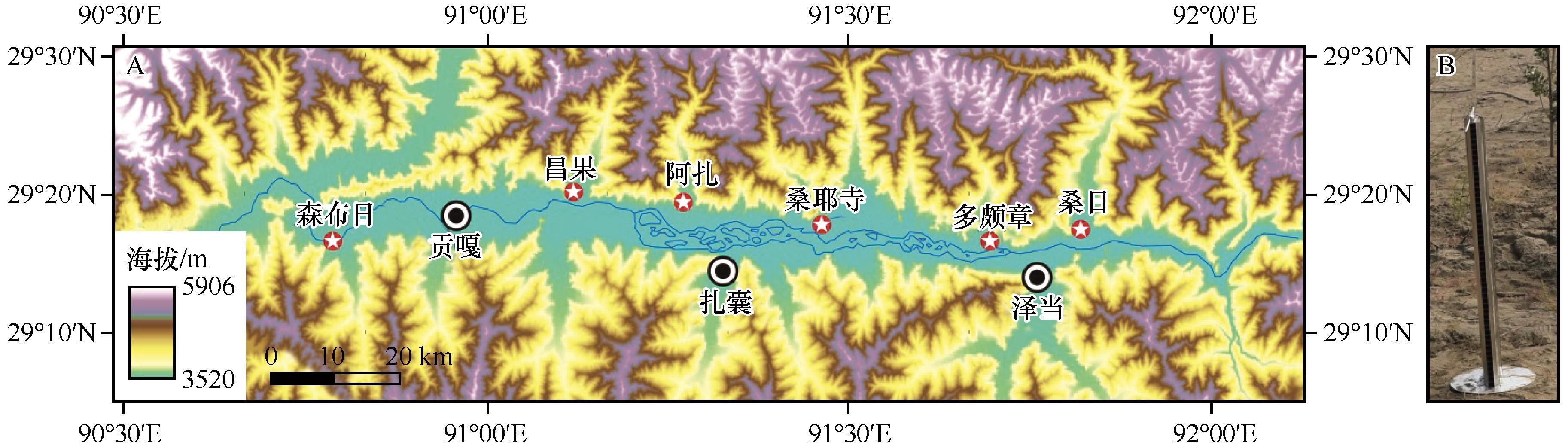
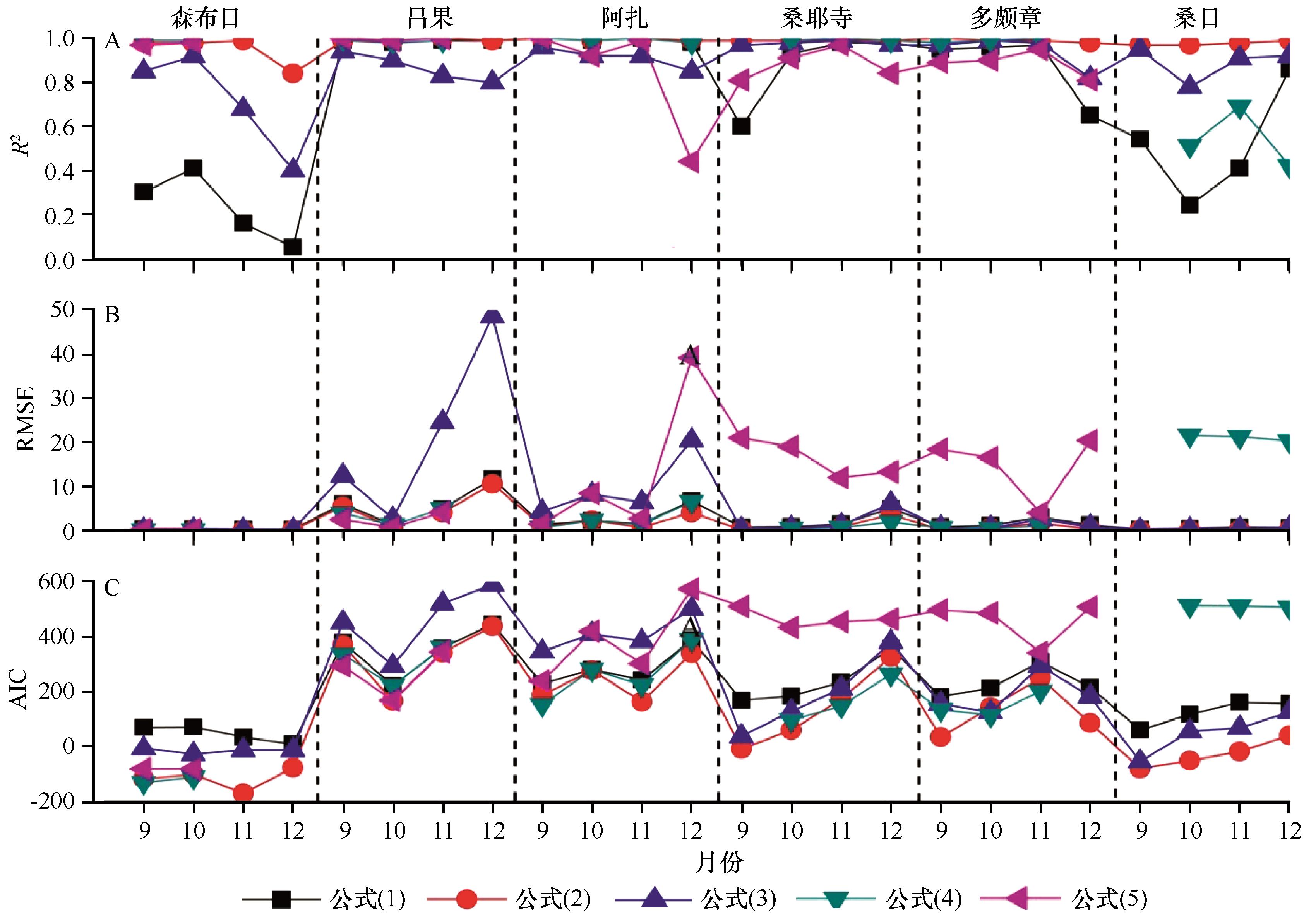
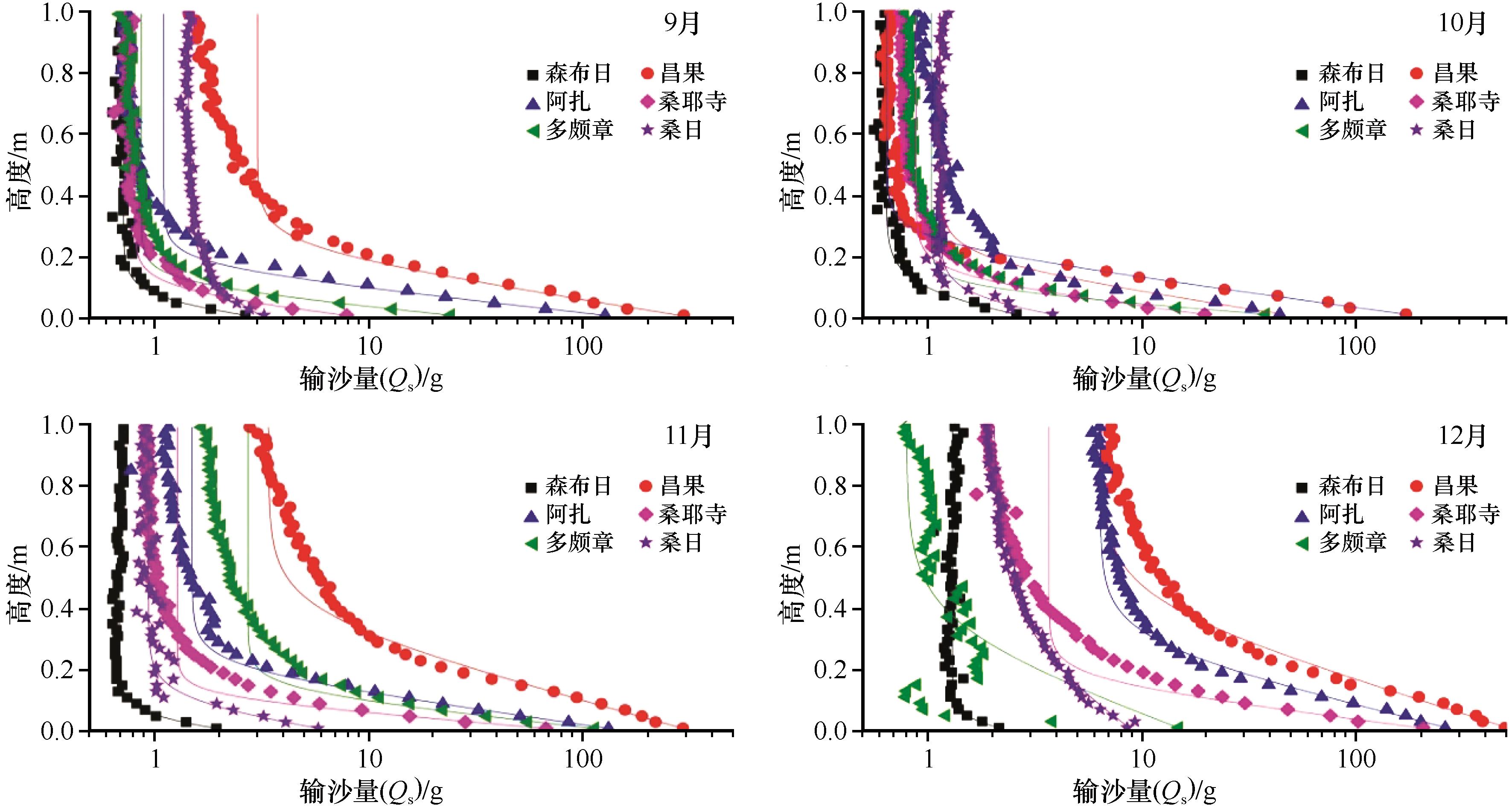
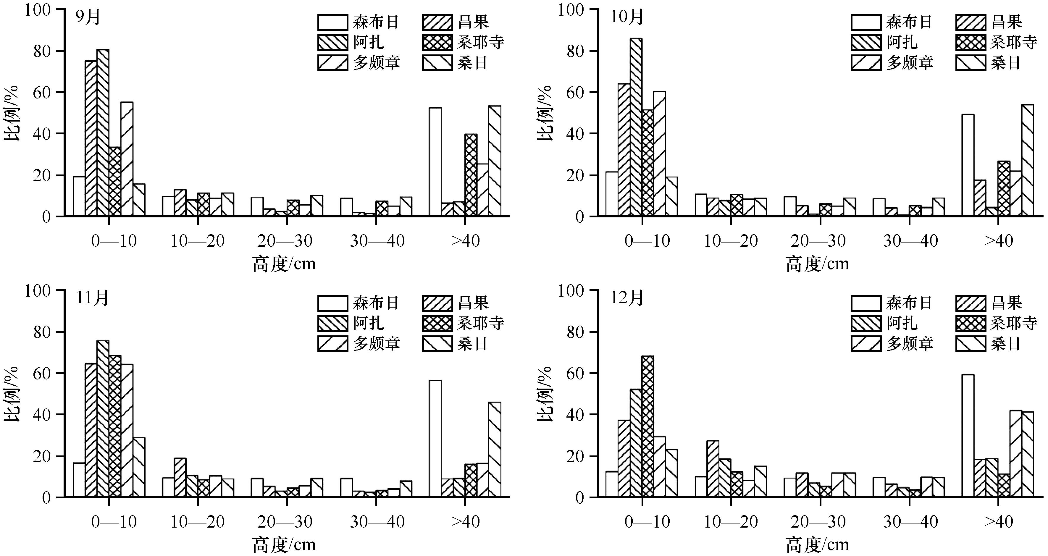
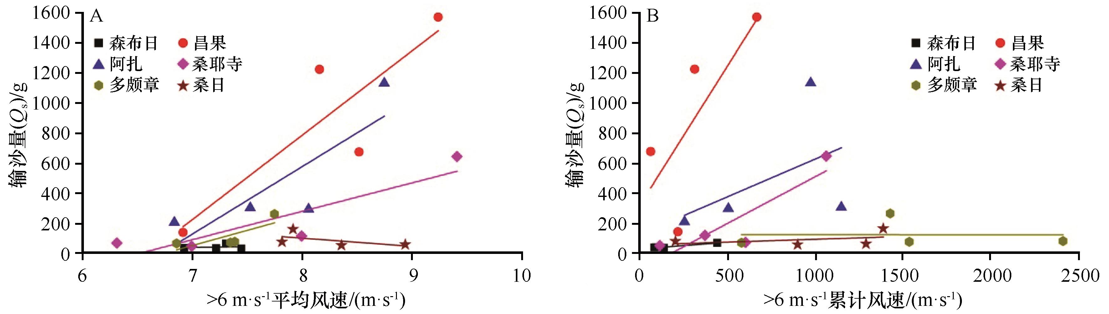
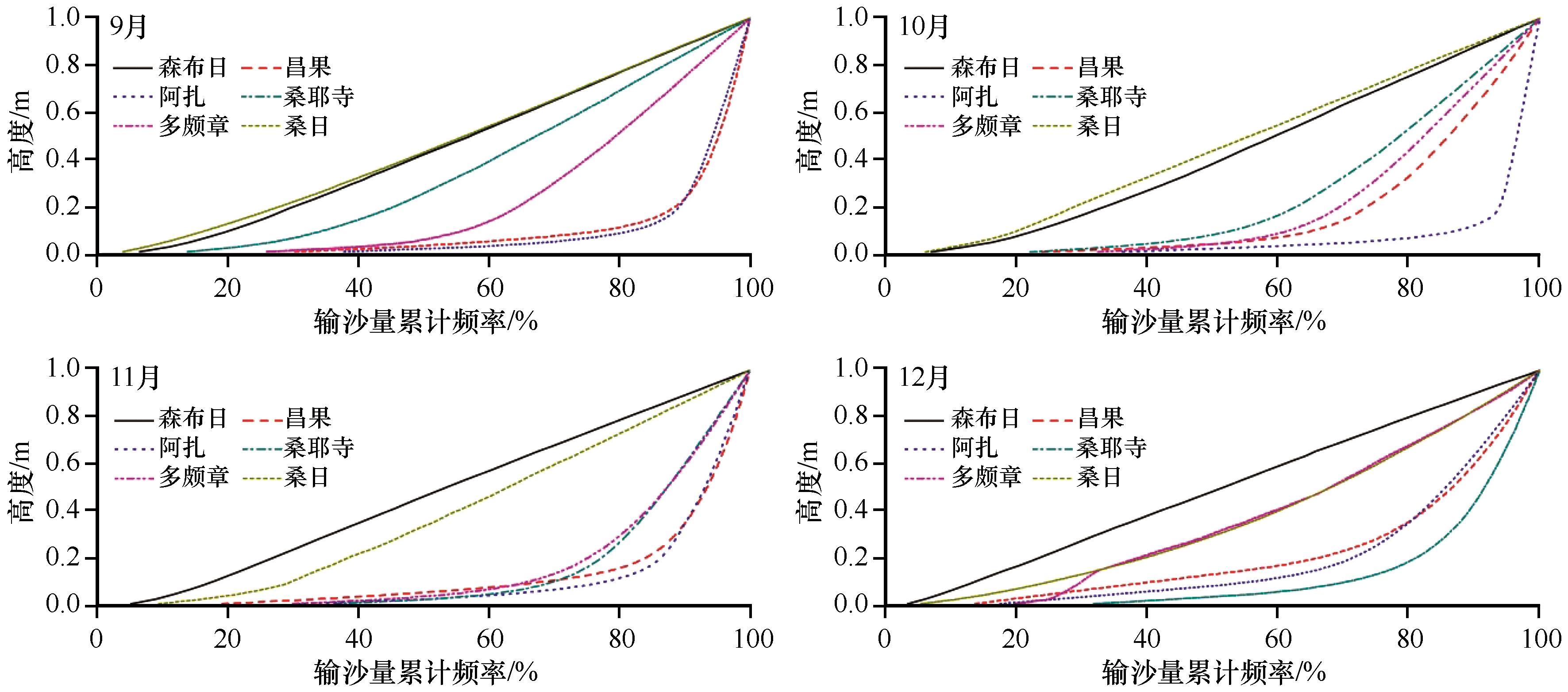
雅鲁藏布江河流宽谷区是青藏高原风沙活动最为强烈地区之一。输沙量是评价区域风沙活动的最主要指标之一,但目前对该地区输沙量的研究几乎是空白。利用旋转多路方口集沙仪对雅鲁藏布江流域中游河岸沙地、河漫滩沙地和山麓沙地3种地表类型、6个点2020年9—12月的输沙量进行野外实地观测,对比不同下垫面的输沙量,分析地表特征对输沙量的影响过程。结果表明:风沙流结构和总输沙量具有明显空间差异性,风沙流结构可以用指数函数表达。观测期间各观测点月平均风速差值变化较小,介于0.31 m·s-1(昌果)到1.19 m·s-1(多颇章),所以沙源和下垫面特征是影响研究区输沙量时空差异的主要因子。昌果沙源最丰富,所以输沙量最大(月平均903.0 g),森布日沙源几乎没有变化且生长植被,所以输沙量最小(月平均43.7 g),说明河岸流沙区的风沙活动最为强烈。近地层1 m高度的输沙量在河漫滩沙地(森布日、桑日)、河岸沙地(昌果、阿扎)和山麓沙地(桑耶寺、多颇章)明显不同,说明输沙量与地表植被特征和沙源密切相关,且沙粒运动过程具有比平原更高、更远的特点。根据近地层风沙流结构、输沙量和累计输沙量频率曲线,研究区的防沙治沙应该以河岸和河漫滩为重点。

关键词: 雅鲁藏布江, 风沙活动, 集沙仪, 输沙量

Abstract:

Yarlung Zangbo River is one of the most serious aeolian disaster regions in the Tibet Plateau. Sand transport is often used to assess aeolian activities, however, there are almost no detailed field sand transport measurements in the Yarlung Zangbo River. For this reason, multi-rotation sand samplers were set up on the shifting sand surface, river floodplain and dune field in the mountains in the Yarlung Zangbo River. Sand transport quantities were measured in the six sites during September to December, 2020. The results indicated that sand transport flux has obvious spatial and temporal difference, but can be expressed as exponential functions. For the less wind velocity difference of six sites during experiments, we can derived that sand sources and landscape characteristics all affect the sand transport quantity. Changguo has rich sand sources and caused largest sand transport quantity, Senburi has little sand sources and land covered by vegetation, sand transport quantity is smallest, which means that sand activities are strongest in the river bank. The cumulative sand transport quantities below 1 m height are different for six sites during measurements. Senburi and Sangri have similar characteristics; Changguo, Aza and Duopozhang have similar characteristics, which further indicated that sand transport related sand sources and landscape characteristics. Based on the sand transport flux, total sand transport quantity and cumulative sand transport curves, sand disaster prevention system need to be built in the river bank and river flood plain.

Key words: Yarlung Zangbo River, aeolian activitis, sand samplers, sand transport

中图分类号: