img

官方微信

高级检索

中国沙漠 ›› 2022, Vol. 42 ›› Issue (6): 125-133.DOI: 10.7522/j.issn.1000-694X.2022.00034

• • 上一篇    

基于气象干旱综合监测指数(MCI)的陕西省干旱灾害风险评估与区划

赵晓萌1,2(), 雷田旺3(), 范婧儿4, 韩莹1,2, 王琦1,2   

  1. 1.陕西省气候中心,陕西 西安 710014
    2.陕西省气象局 秦岭和黄土高原生态环境气象重点实验室,陕西 西安 710014
    3.西安交通工程学院,陕西 西安 710065
    4.西安市气象局,陕西 西安 710016
  • 收稿日期:2022-01-24 修回日期:2022-04-06 出版日期:2022-11-20 发布日期:2023-01-09
  • 通讯作者: 雷田旺
  • 作者简介:雷田旺(E-mail: ltw0229@163.com
    赵晓萌(1985—),女,陕西咸阳人,高级工程师,硕士,从事气候监测与灾害评估工作。E-mail: xmzhao2011@163.com
  • 基金资助:
    陕西省自然科学基础研究计划项目(2021SF-493);陕西省气象局秦岭和黄土高原生态环境气象重点实验室开放研究基金课题(2019Y-7)

Risk assessment and regionalization of drought disasters in different seasons in Shaanxi, China based on MCI

Xiaomeng Zhao1,2(), Tianwang Lei3(), Jinger Fan4, Ying Han1,2, Qi Wang1,2   

  1. 1.Shaanxi Climate Center,Xi'an 710014,China
    2.Shaanxi Key Laboratory of Eco-Environment and Meteorology for the Qinling Mountains and Loess Plateau,Shaanxi Meteorological Bureau,Xi'an 710014,China
    3.Xi'an Traffic Engineering Institute,Xi'an 710065,China
    4.Xi'an Meteorological Bureau,Xi'an 710016,China
  • Received:2022-01-24 Revised:2022-04-06 Online:2022-11-20 Published:2023-01-09
  • Contact: Tianwang Lei

摘要:

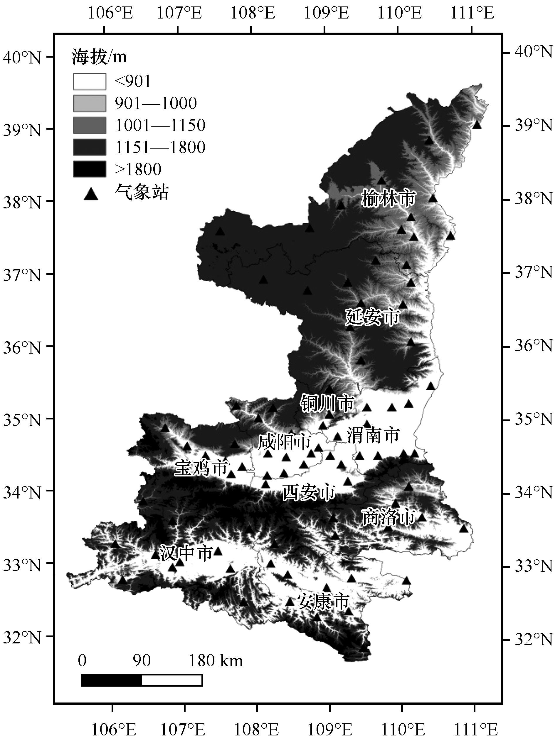
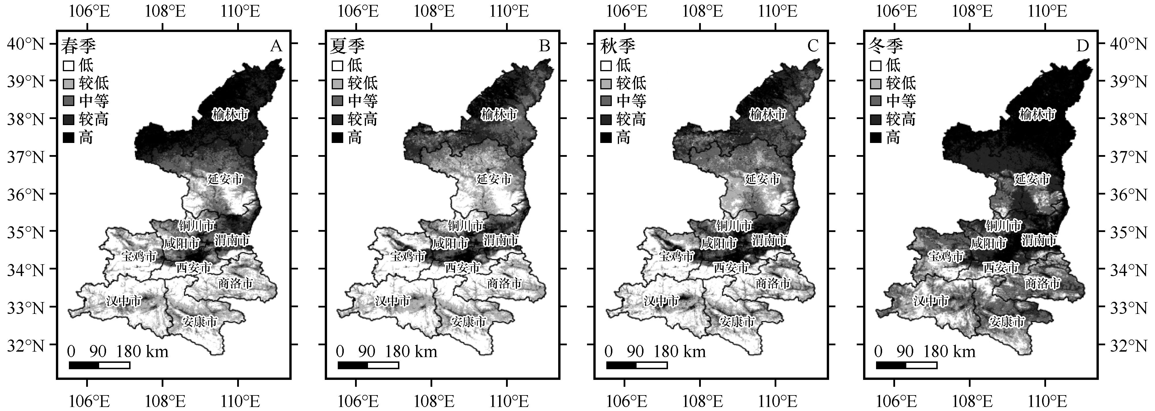
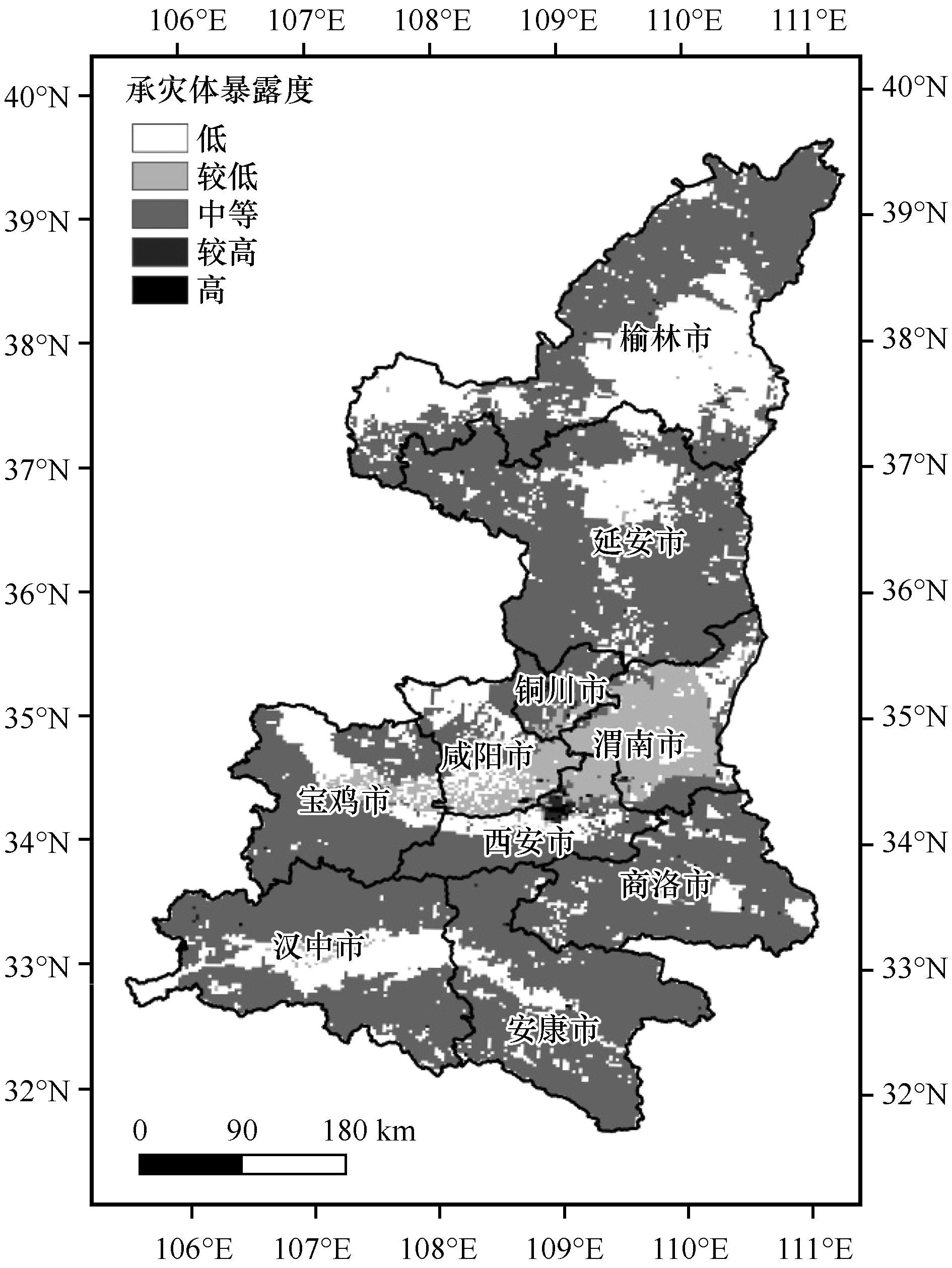
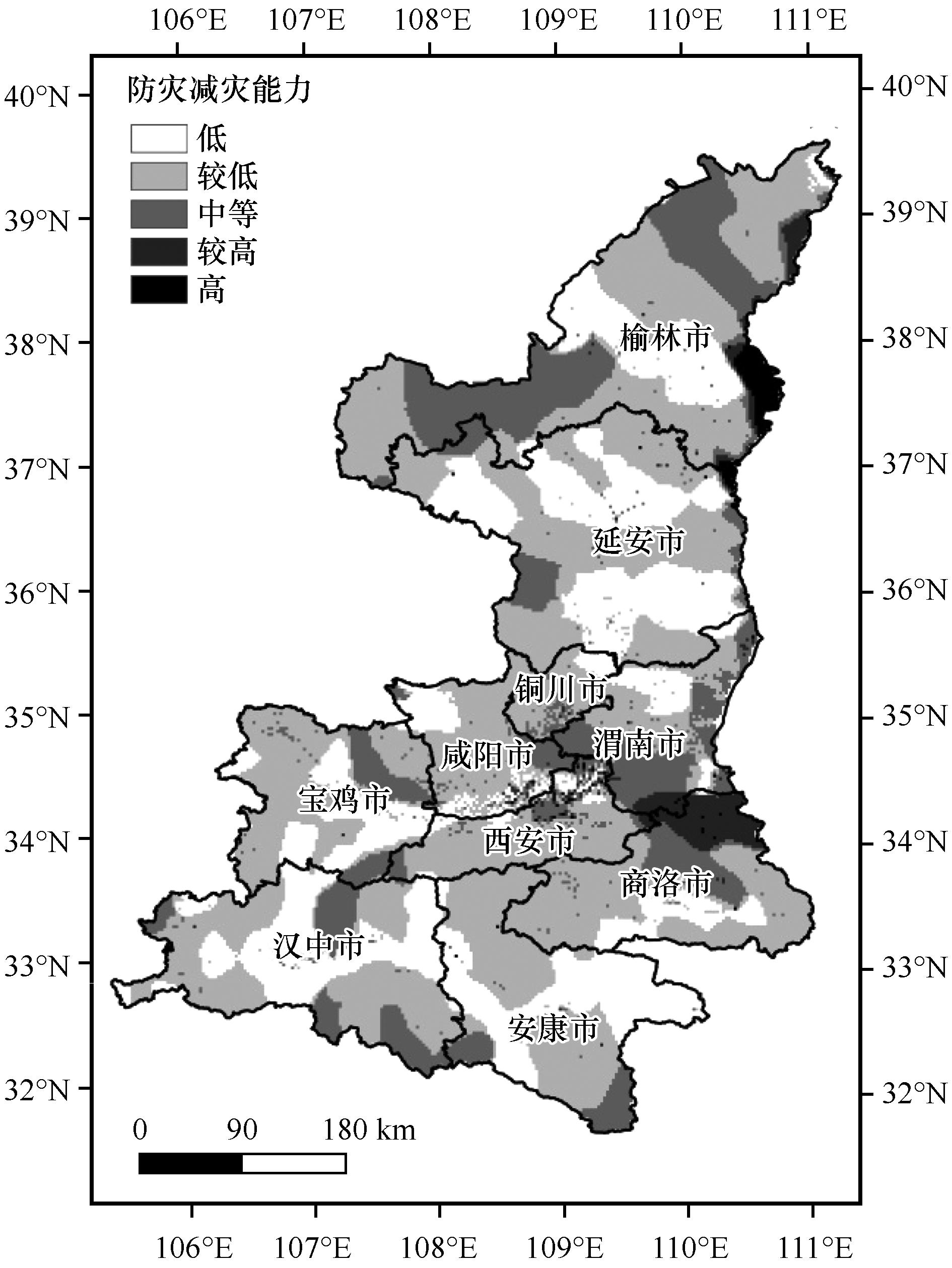
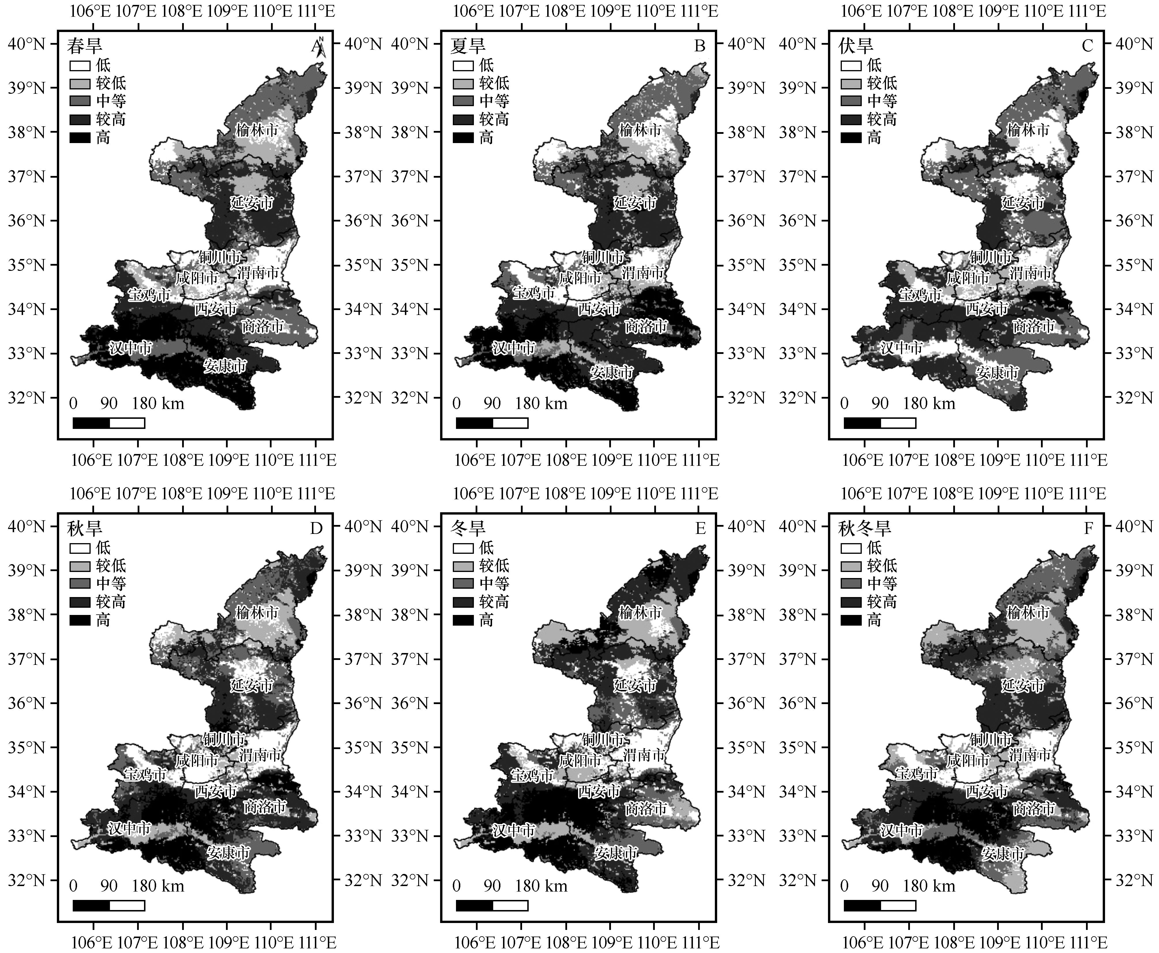
利用陕西省94个国家气象站1961—2018年逐日气象资料,根据干旱灾害气候背景和社会经济环境,结合灾害风险评估相关理论方法,选取致灾因子危险性、孕灾环境脆弱性、承灾体暴露度、防灾减灾能力4个方面指标,建立干旱灾害风险评估指数,基于GIS平台,对陕西省不同季节进行干旱灾害风险区划。结果表明:(1)陕西各区域干旱致灾因子危险性季节差异明显,陕北北部除夏季外各季节干旱危险性较高,关中地区易发生伏旱。陕南的汉中各季节干旱危险性均较大,安康东部和商洛各季节干旱危险性则较小。(2)春季、夏季和秋季,陕南的汉中平原及安康的汉江河谷地带,关中的西安和渭南地区,陕北北部榆林地区为干旱孕灾环境高脆弱性区或较高区;冬季陕南大部、秦岭地区的高脆弱性区较其他三季范围有所减小;海拔较高的秦岭山地,关中平原和陕北北部各季节皆为低脆弱性或较低脆弱性地区。(3)承灾体暴露度的高风险区主要分布于关中地区。(4)全省抵御干旱风险能力最高地区为陕北黄河沿线、关中各地的城镇地区。(5)干旱灾害综合风险的高风险区主要在陕南巴山地区、秦岭南北两侧、陕北南部,陕南汉江平原、关中平原及陕北延安、榆林等地为干旱较低、低风险区。

关键词: 干旱灾害风险, 评估, 区划, MCI

Abstract:

Using the daily data from 94 meteorological stations of Shaanxi Province from 1961 to 2018, according to the climatic background of drought disasters and the social-economic environment, combined with the theory of disaster risk, the drought disaster risk index system and model is established based on risk hazard factors, subsequently environmental vulnerability and disaster bearing bodies exposure and disaster prevention and mitigation capacity reliability. Based on the GIS platform, drought disaster risk regionalization in different seasons in Shaanxi Province is carried out. The research results show that: (1) There are obvious seasonal differences in the risk of drought disaster causing factors in various regions of Shaanxi. The drought risk in the northern of Shaanxi is higher in all seasons except summer, and the Guanzhong area is prone to summer drought. The drought risk index of Hanzhong in southern Shaanxi is higher, while the drought risk index of east Ankang and Shangluo is lower. (2) In spring, summer and autumn, the Hanzhong Plain in southern Shaanxi and the Ankang Hanjiang River Valley, Xi'an and Weinan in Guanzhong, and Yulin in northern Shaanxi are high risk areas or sub high risk areas of drought disaster environmental vulnerability. In winter, the high risk areas in most southern Shaanxi and Qinling are smaller than those in other three seasons; Qinling Mountains with higher altitude, Guanzhong Plain and northern Shaanxi are low risk or sub-low risk areas in all seasons. (3) The high risk areas of disaster bearing body exposure are mainly distributed in Guanzhong area. (4) The areas with the highest disaster prevention and mitigation capacity reliability in the province are urban areas along the Yellow River in northern Shaanxi and all over Guanzhong. (5) The high risk areas of drought disaster comprehensive risk are mainly in Bashan area in southern Shaanxi, the north and south sides of Qinling Mountains, and the south of northern Shaanxi. Hanjiang Plain in southern Shaanxi, Guanzhong Plain, Yan'an and Yulin in northern Shaanxi are low risk areas of drought.

Key words: drought disaster risk, assessment, regionalization, MCI

中图分类号: