| 1 |
王仁德,吴晓旭.毛乌素沙地治理的新模式[J].水土保持研究,2009,16(5):176-180.
|
| 2 |
周淑琴,荆耀栋,张青峰,等.毛乌素沙地南缘植被景观格局演变与空间分布特征[J].生态学报,2013,33(12):3774-3782.
|
| 3 |
马雄德,范立民.榆神矿区地下水与生态环境演化特征[J].煤炭科学技术,2019,47(10):245-252.
|
| 4 |
赵媛媛,丁国栋,高广磊,等.毛乌素沙区沙漠化土地防治区划[J].中国沙漠,2017,37(4):635-643.
|
| 5 |
程东会,王文科,侯光才,等.毛乌素沙地植被与地下水关系[J].吉林大学学报(地球科学版),2012,42(1):184-189.
|
| 6 |
Yang Z,Zhou Y X,Wenninger J,et al.Groundwater and surface-water interactions and impacts of human activities in the Hailiutu catchment, northwest China[J].Hydrogeology Journal,2017,25(5):1341-1355.
|
| 7 |
范立民.保水采煤的科学内涵[J].煤炭学报,2017,42(1):27-35.
|
| 8 |
石辉,刘秀花,陈占飞,等.陕北榆林毛乌素沙地大规模土地整治开发的生态环境问题及其对策[J].生态学杂志,2019,38(7):2228-2235.
|
| 9 |
Yang Z Y,Wang K,Yuan Y,et al.Non-negligible lag of groundwater infiltration recharge:a case in Mu Us Sandy Land, China[J].Water,2019,11(3):561.
|
| 10 |
Touch S,Likitlersuang S,Pipatpongsa T,et al.3D geological modelling and geotechnical characteristics of Phnom Penh subsoils in Cambodia[J].Engineering Geology,2014,178:58-69.
|
| 11 |
龚继文,李崇明,程艳茹,等.基于GMS的山区三维地质模型及应用研究[J].长江流域资源与环境,2016,25(7):1135-1141.
|
| 12 |
冯波,陈明涛,岳冬冬,等.基于两种插值算法的三维地质建模对比[J].吉林大学学报(地球科学版),2019,49(4):1200-1208.
|
| 13 |
覃文忠.地理加权回归基本理论与应用研究[D].上海:同济大学,2007.
|
| 14 |
杨光,粟晓玲.基于随机森林的黑河中游地下水埋深变化及成因[J].水土保持研究,2017,24(1):109-114.
|
| 15 |
肖琼,张志诚,谢磊,等.昌源河国家湿地公园含水层水文地质特征研究[J].中国地质,2017,44(5):1006-1016.
|
| 16 |
黄元,岳德鹏,于强,等.磴口县地表水与地下水时空变化特征及交互作用[J].中国沙漠,2019,39(1):161-170.
|
| 17 |
刘畅,李凤日,甄贞.空间误差模型在黑龙江省森林碳储量空间分布的应用[J].应用生态学报,2014,25(10):2779-2786.
|
| 18 |
Aghadadashi V,Molaei S,Mehdinia A,et al.Using GIS,geostatistics and Fuzzy logic to study spatial structure of sedimentary total PAHs and potential eco-risks:an Eastern Persian Gulf case study[J].Marine Pollution Bulletin,2019,149:110489.
|
| 19 |
Ginebreda A,Sabater-Liesa L,Rico A,et al. Reconciling monitoring and modeling:an appraisal of river monitoring networks based on a spatial autocorrelation approach-emerging pollutants in the Danube River as a case study[J].The Science of the Total Environment,2018,618:323-335.
|
| 20 |
宋文,陈英.土地利用空间自相关分析中观测变量和衡量指标的选择研究[J].干旱区资源与环境,2015,29(10):37-42.
|
| 21 |
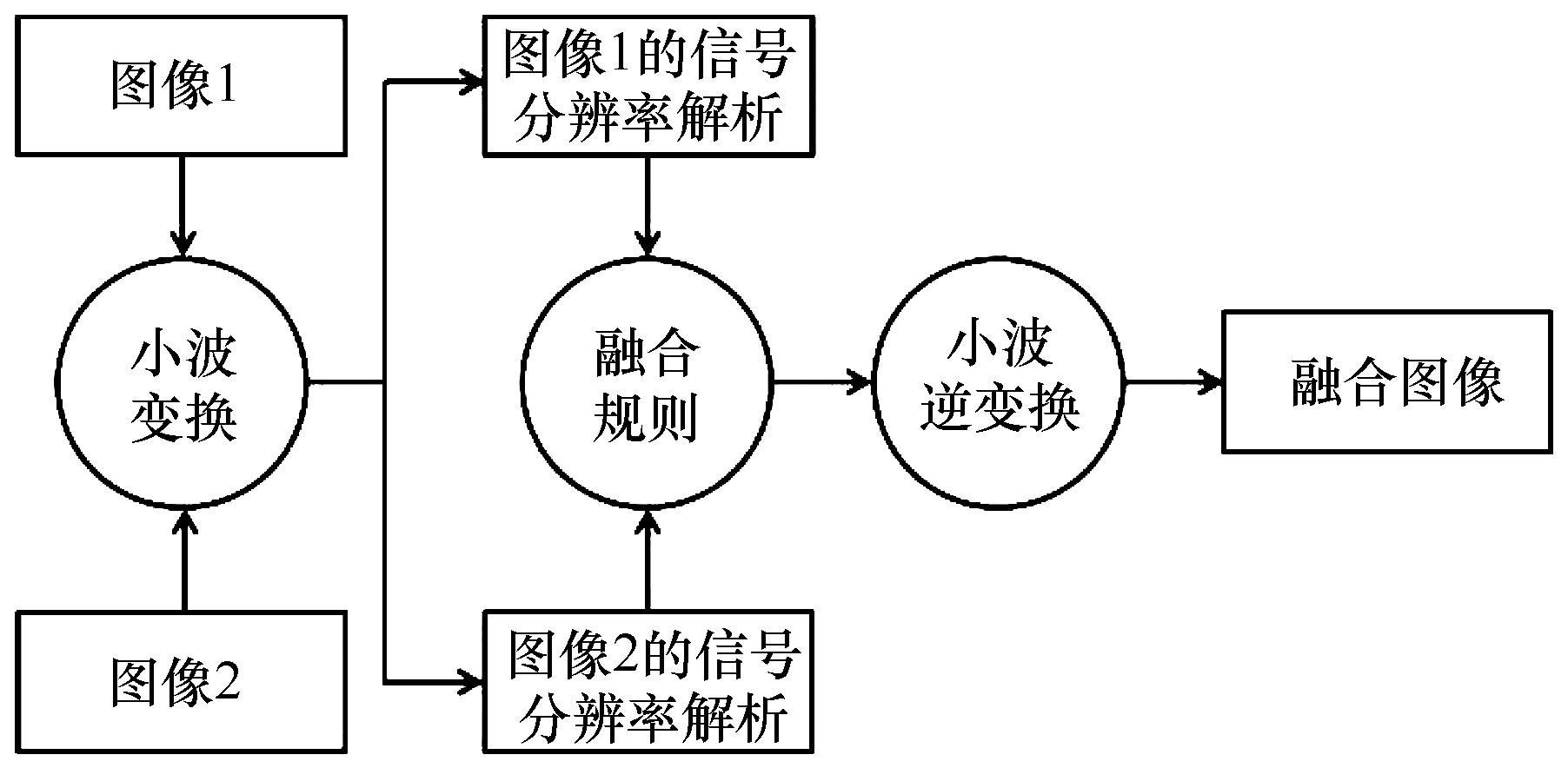
陈浩,王延杰.基于小波变换的图像融合技术研究[J].微电子学与计算机,2010,27(5):39-41.
|
| 22 |
王向东,杨风暴,焦玉茜,等.面向图像差异特征融合的基于弗里德曼检验的小波基分类研究[J].红外技术,2019,41(1):44-53.
|
| 23 |
余汪洋,陈祥光,董守龙,等.基于小波变换的图像融合算法研究[J].北京理工大学学报,2014,34(12):1262-1266.
|
| 24 |
Sappa A D,Carvajal J A,Aguilera C A,et al.Wavelet-based visible and infrared image fusion: a comparative study[J].Sensors,16(6):861-876.
|
| 25 |
侯光才,张茂省,王永和,等.鄂尔多斯盆地地下水资源与开发利用[J].西北地质,2007(1):7-34.
|
| 26 |
吴丽丽,刘丹一,杨文斌,等.降雨量、土壤蓄水量对流动沙地土壤水分深层渗漏的影响[J].中国沙漠,2020,40(3):210-218.
|
| 27 |
张徽.陕北风沙滩地区地下水数值仿真模拟及可持续利用[D].西安:长安大学,2007.
|
| 28 |
白乐,李怀恩,何宏谋,等.煤矿开采区地表水-地下水耦合模拟[J].煤炭学报,2015,40(4):931-937.
|
| 29 |
El-Rawy M,De Smedt F,Zijl W.Zone-integrated double-constraint methodology for calibration of hydraulic conductivities in grid cell clusters of groundwater flow models[J].Transport in Porous Media,2018,122(3):633-645.
|
| 30 |
徐永亮,于静洁,张一驰,等.生态输水期间额济纳绿洲区地下水动态数值模拟[J].水文地质工程地质,2014,41(4):11-18.
|
| 31 |
张保建.基于Visual Modflow的台格庙勘查区矿井涌水量预测[J].煤炭科学技术,2015,43():146-149,172.
|
 ), 刘廷玺1,2(
 甘公网安备 62010202000688号