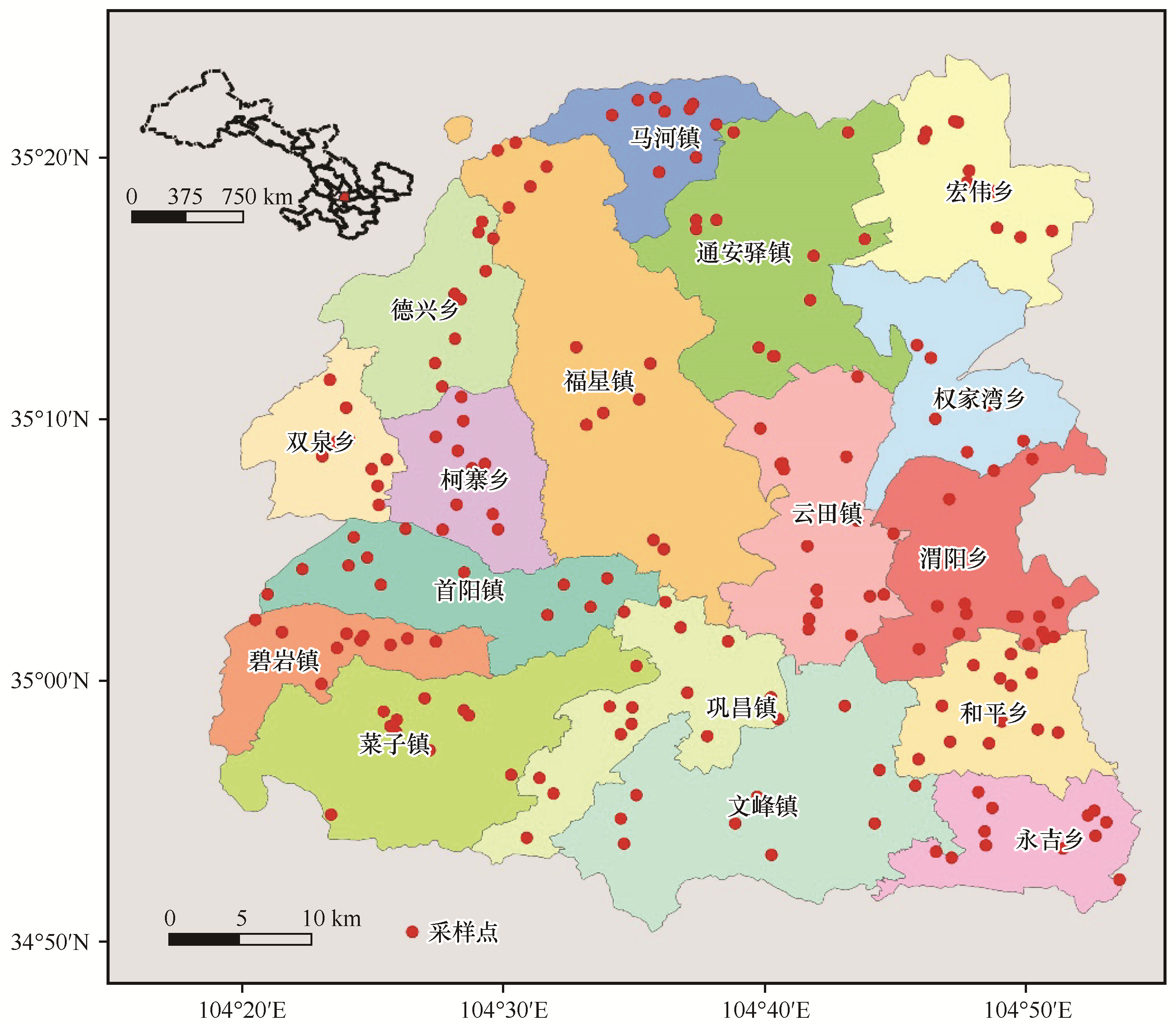
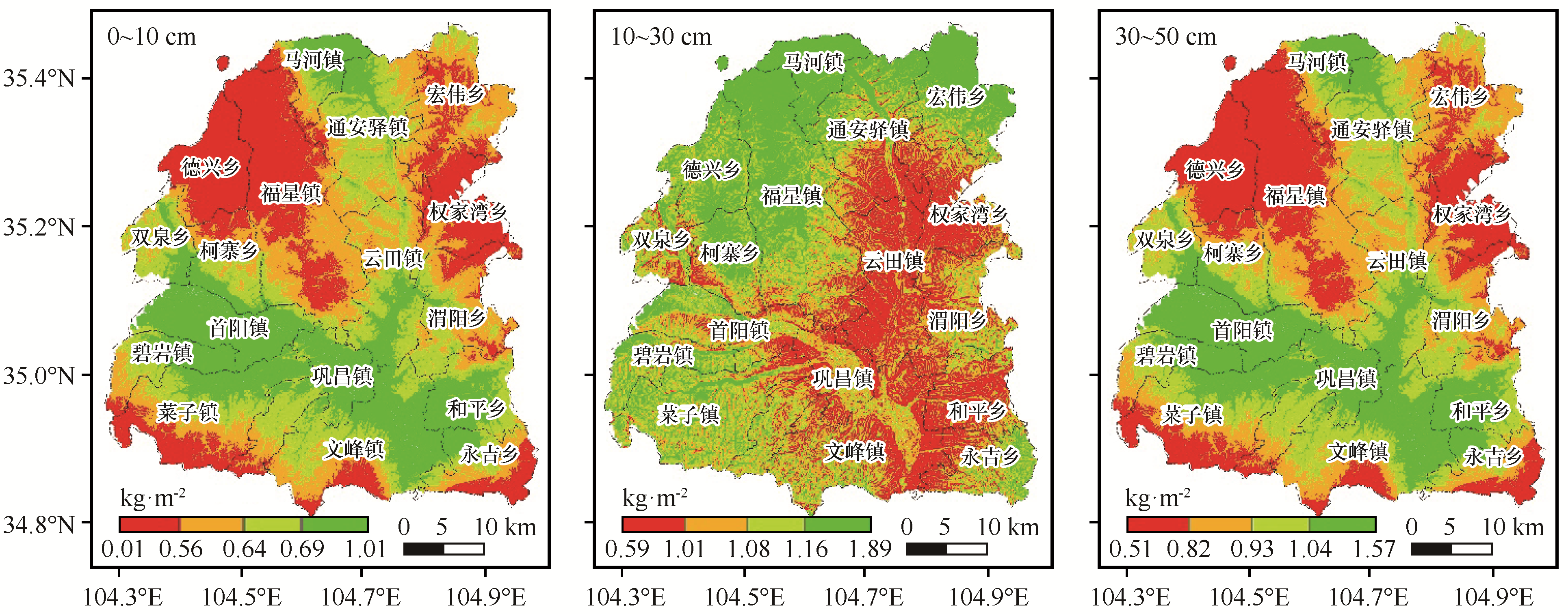
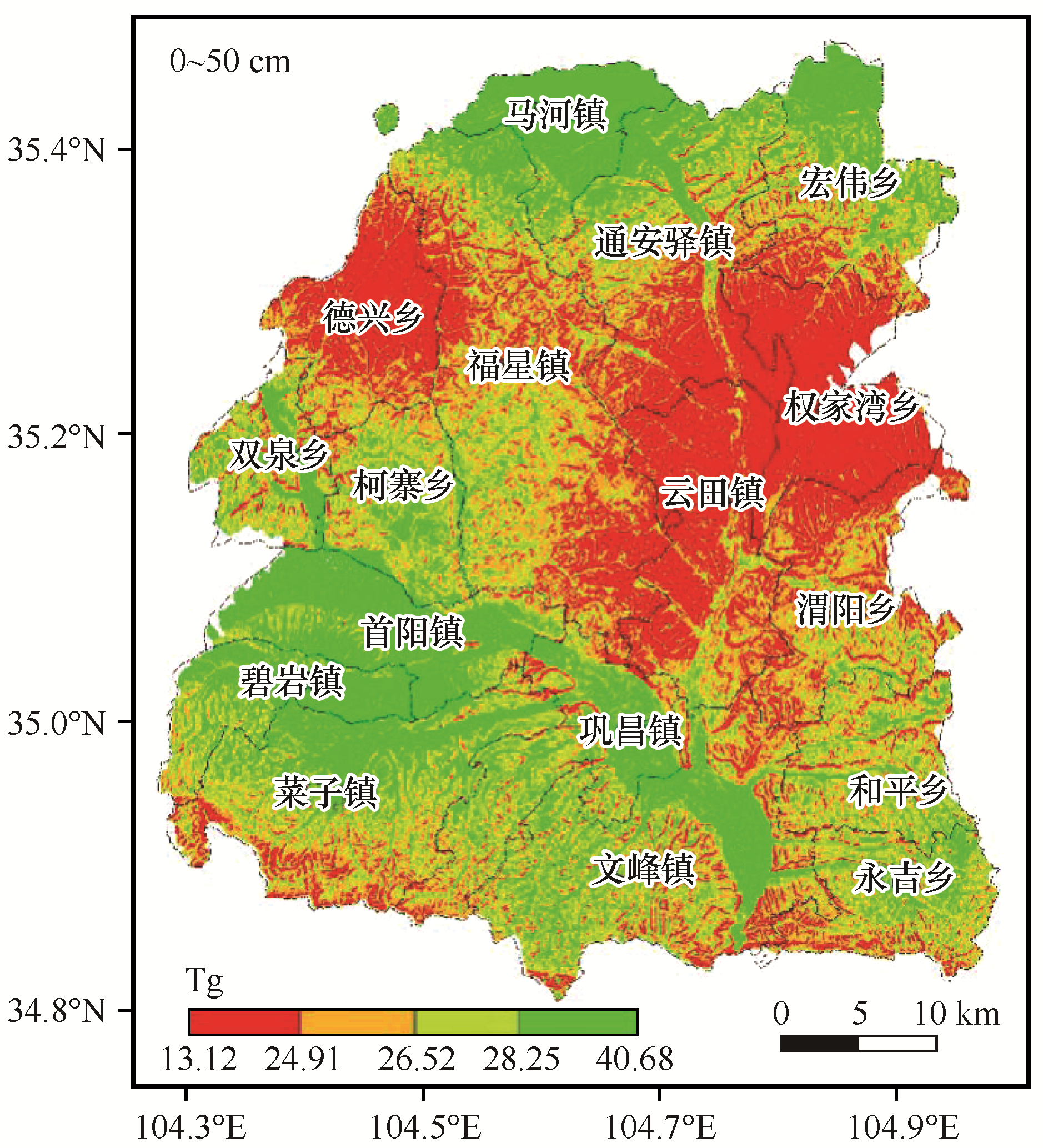
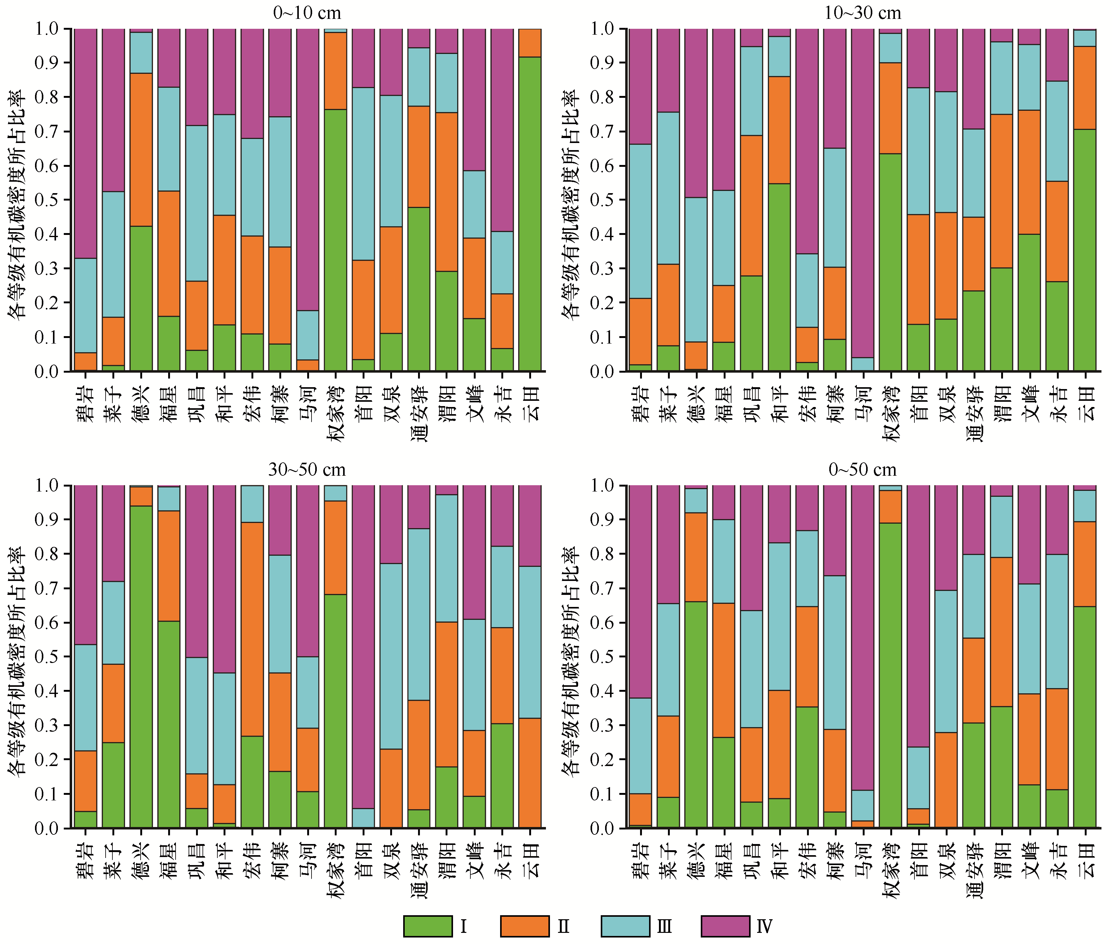
| 1 |
安玲玲,吕晓男,麻万诸,等.浙江省土壤有机碳密度与储量的初步研究[J].浙江农业学报,2014,26(1):148-153.
|
| 2 |
Tiessen H,Cuevas E,Chacon P.The role of soil organic matter in sustaining soil fertility[J].Nature,1994,371:783-785.
|
| 3 |
Loveland P,Webb J.Is there a critical level of organic matter in the agricultural soils of temperate regions: a review[J].Soil & Tillage Research,2003,70(1):1-18.
|
| 4 |
王绍强,周成虎,李克让,等.中国土壤有机碳库及空间分布特征分析[J].地理学报,2000,55(5):533-544.
|
| 5 |
Huang Y,Sun W J.Changes in topsoil organic carbon of croplands in mainland China over the last two decades[J].Chinese Science Bulletin,2006,51(15):1785-1803.
|
| 6 |
陇西县志编纂委员会.陇西县志[M].兰州:甘肃人民出版社,1990.
|
| 7 |
陈可.基于复杂环境区域的土壤有机质空间预测研究[D].武汉:华中农业大学,2018.
|
| 8 |
解宪丽,孙波,周慧珍,等.中国土壤有机碳密度和储量的估算与空间分布分析[J].土壤学报,2004,41(1):35-43.
|
| 9 |
刘文辉,李春亮,吴永强.甘肃省兰州-白银地区土壤有机碳库储量估算与空间分布特征[J].物探与化探,2012,36(3):367-371.
|
| 10 |
刘文辉.甘肃省张掖-永昌地区土壤有机碳密度估算及其空间分布特征[J].物探与化探,2013,37(3): 552-556.
|
| 11 |
陈曦.广西土壤有机碳储量估算及与全国部分省区的比较研究[J].地理科学,2014,34(10):1247-1253.
|
| 12 |
钟聪,杨忠芳,夏学齐,等.青海省土壤有机碳储量估算及其源汇因素分析[J].现代地质,2012,26(5):896-909.
|
| 13 |
傅野思,夏学齐,杨忠芳,等.内蒙古自治区土壤有机碳库储量及分布特征[J].现代地质,2012,26(5):886-895.
|
| 14 |
代杰瑞,庞绪贵,曾宪东,等.山东省土壤有机碳密度的空间分布特征及其影响因素[J].环境科学研究,2015,28(9):1449-1458.
|
| 15 |
袁芳,赵小敏,乐丽红,等.江西省表层土壤有机碳库储量估算与空间分布特征[J].生态环境,2008,17(1):268-272.
|
| 16 |
于沙沙,窦森,黄健,等.吉林省耕层土壤有机碳储量及影响因素[J].农业环境科学学报,2014,33(10):1973-1980.
|
| 17 |
张圣民.黄土高原农田土壤有机碳储量及固碳能力研究[D].陕西杨凌:西北农林科技大学,2018.
|
| 18 |
孙忠祥,李勇,赵云泽,等.旱作区土壤有机碳密度空间分布特征与其驱动力分析[J].农业机械学报,2019,50(1):255-262.
|
| 19 |
江叶枫,饶磊,郭熙,等.江西省耕地土壤有机碳空间变异的主控因素研究[J].土壤,2018,50(4):778-786.
|
| 20 |
解文艳,周怀平,杨振兴,等.黄土高原东部潇河流域农田土壤有机质时空变异及影响因素[J].农业资源与环境学报,2019,36(1):96-104.
|
| 21 |
钟聪,杨忠芳,胡宝清,等.河北平原区土壤有机碳及其对气候变化的响应[J].农业现代化研究,2016,37(4):809-816.
|
| 22 |
张城,王绍强,于贵瑞,等.中国东部地区典型森林类型土壤有机碳储量分析[J].资源科学,2006,28(2):97-103.
|
| 23 |
曾希柏.耕地质量培育技术与模式[C].北京:中国农业出版社,2014.
|
| 24 |
刘书田.中国农田土壤有机碳时空分布规律及影响因素研究[D].长春:吉林农业大学,2016.
|
| 25 |
Silver W L,Lugo A E,Keller M.Soil oxygen availability and biogeochemistry along rainfall and topographic gradients in upland wet tropical forest soils[J].Biogeochemistry,1999,44(3):301-328.
|
| 26 |
林维,崔晓阳.地形因子对大兴安岭北端寒温带针叶林土壤有机碳储量的影响[J].森林工程,2017,33(3):1-6.
|
| 27 |
赵西宁,吴发启,王万忠.黄土高原沟壑区坡耕地土壤入渗规律研究[J].干旱区资源与环境,2004,18(4):109-112.
|
| 28 |
牛伊宁,南志标,沈禹颖.陇东黄土高原地表粗糙度对耕作土壤径流的影响[J].干旱区研究,2011,28(3):389-393.
|
| 29 |
肖林林.山地丘陵区耕地土壤有机碳密度空间变异特征分析及预测[D].重庆:西南大学,2013.
|
| 30 |
丛山.温度和水分对吉林省主要耕作土壤有机质矿化影响的模拟研究[D].长春:吉林农业大学,2016.
|
| 31 |
郭晓伟,骆土寿,李意德,等.尖峰岭热带山地雨林土壤有机碳密度空间分布特征[J].生态学报,2015,35(23):7878-7886.
|
| 32 |
李斌,方晰,李岩,等.湖南省森林土壤有机碳密度及碳库储量动态[J].生态学报,2015,35(13):4265-4278.
|
| 33 |
王鹏程,邢乐杰,肖文发,等.三峡库区森林生态系统有机碳密度及碳储量[J].生态学报,2009,29(1):97-107.
|
| 34 |
于建军,杨锋,吴克宁,等.河南省土壤有机碳储量及空间分布[J].应用生态学报,2008,19(5):1058-1063.
|
| 35 |
Yang W Q,Deng R J,Zhang J.Forest litter decomposition and its responses to global climate change[J].The Journal of Applied Ecology,2007,18(12): 2889-2895.
|
| 36 |
Usman S,Singh S P,Rawat Y S,et al.Fine root decomposition and nitrogen mineralisation patterns in Quercus leucotrichophora and Pinus roxburghii forests in central Himalaya[J].Forest Ecology and Management,2000,131(1/2/3):191-199.
|
| 37 |
高石曼,刘久石,孙恬,等.不同栽培措施对党参药材化学质量的影响[J].中国中药杂志,2016,41(20):3753-3760.
|
| 38 |
张琳,王晓,史国玉,等.中药连作障碍形成及其时空效应理论探讨[J].现代中药研究与实践,2014,28(5):78-83.
|
| 39 |
龚成文,赵欣楠,冯守疆,等.配方施肥对党参生产特性的影响[J].西北农业学报,2013,22(11):130-136.
|
| 40 |
李振方,杨燕秋,谢冬凤,等.连作条件下地黄药用品质及土壤微生态特性分析[J].中国生态农业学报,2012,20(2):217-224.
|
 ), 何明珠1(
 甘公网安备 62010202000688号