| 1 |
荔琢,蒋卫国.基于生态系统服务价值的京津冀城市群湿地主导服务功能研究[J].自然资源学报,2019,34(8):1654-1665.
|
| 2 |
陈桃,包安明,郭浩,等.中亚跨境流域生态脆弱性评价及其时空特征分析:以阿姆河流域为例[J].自然资源学报,2019,34(12):2643-2657.
|
| 3 |
胡文佳,陈彬,Panichpol Arnupap ,等.珊瑚礁生态脆弱性评价:以泰国思仓岛为例[J].生态学杂志,2020,39(3):979-989.
|
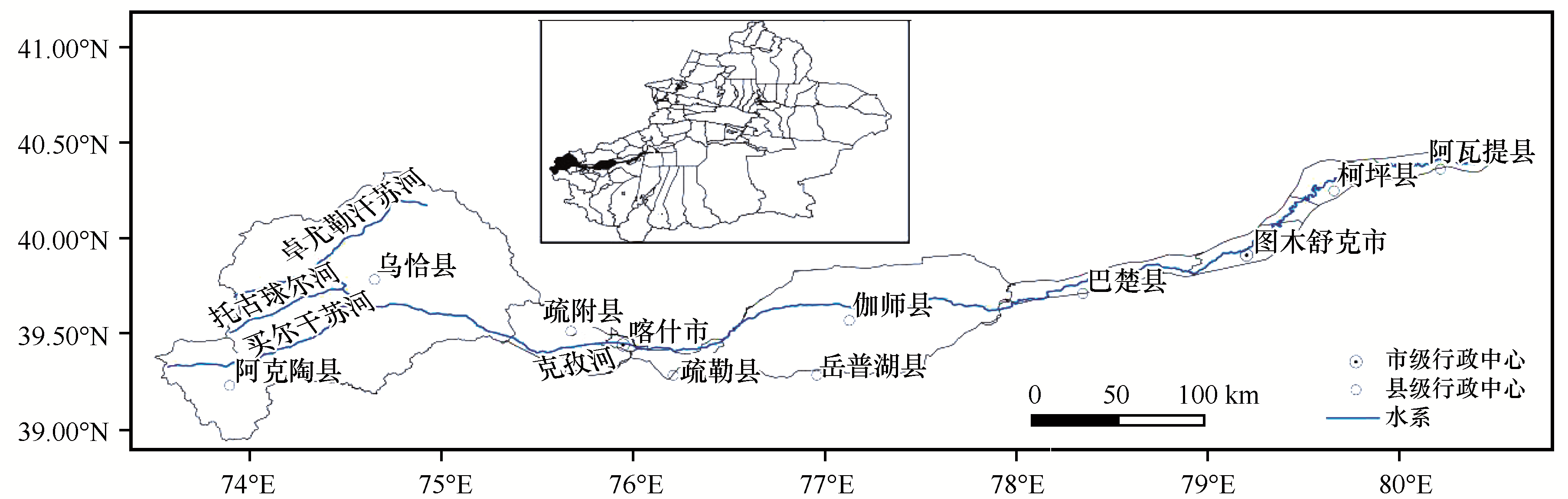
| 4 |
赵志刚,余德,王凯荣,等.赣西地区生态系统服务价值与生态补偿策略[J].生态学报,2020,40(20):7507-7518.
|
| 5 |
马国军,林栋.石羊河流域生态系统服务功能经济价值评估[J].中国沙漠,2009,29(6):1173-1177.
|
| 6 |
刘珍环,张国杰,付凤杰.基于景观格局-服务的景观生态风险评价:以广州市为例[J].生态学报,2020,40(10):3295-3302.
|
| 7 |
付在毅,许学工.区域生态风险评价[J].地球科学进展,2001(2):267-271.
|
| 8 |
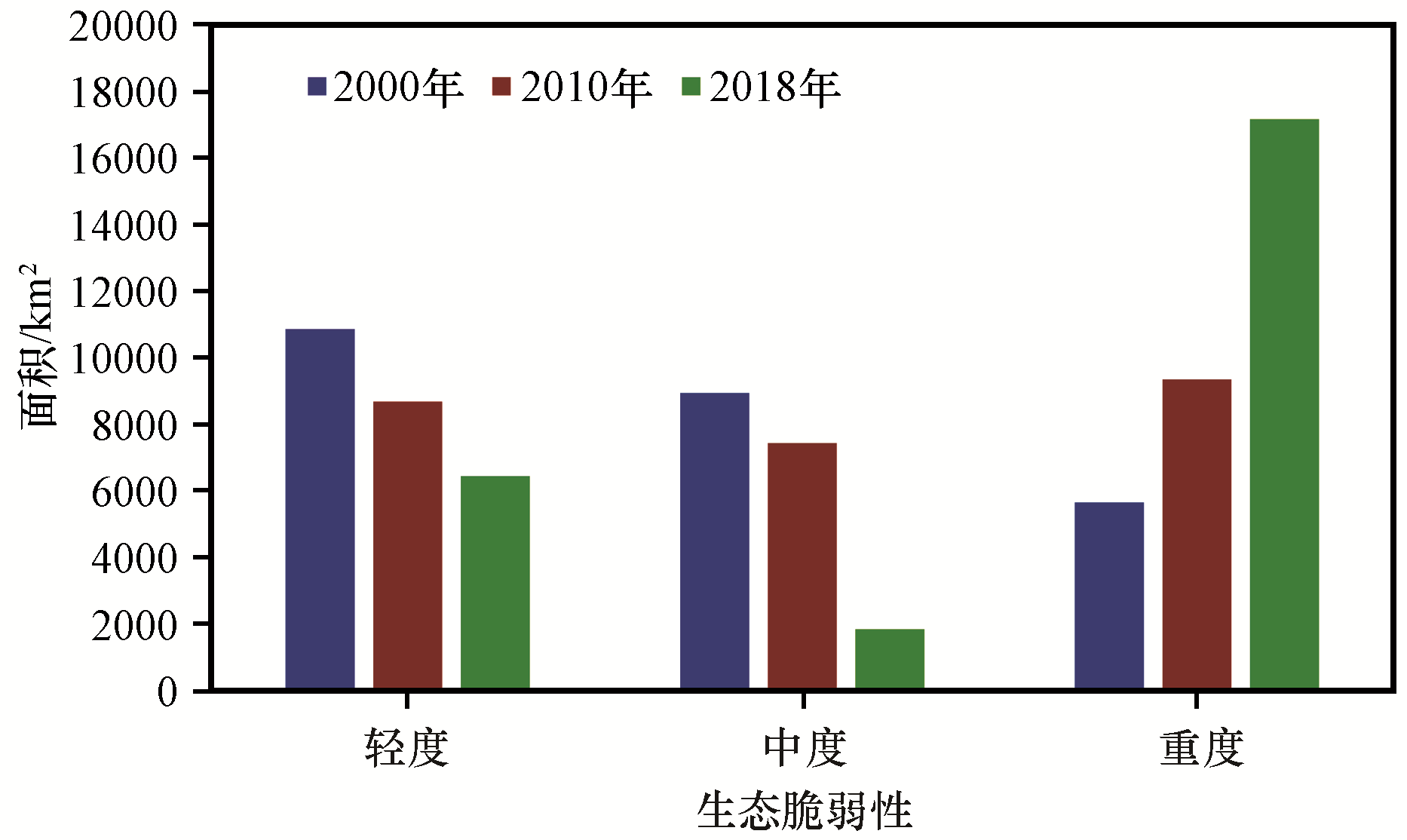
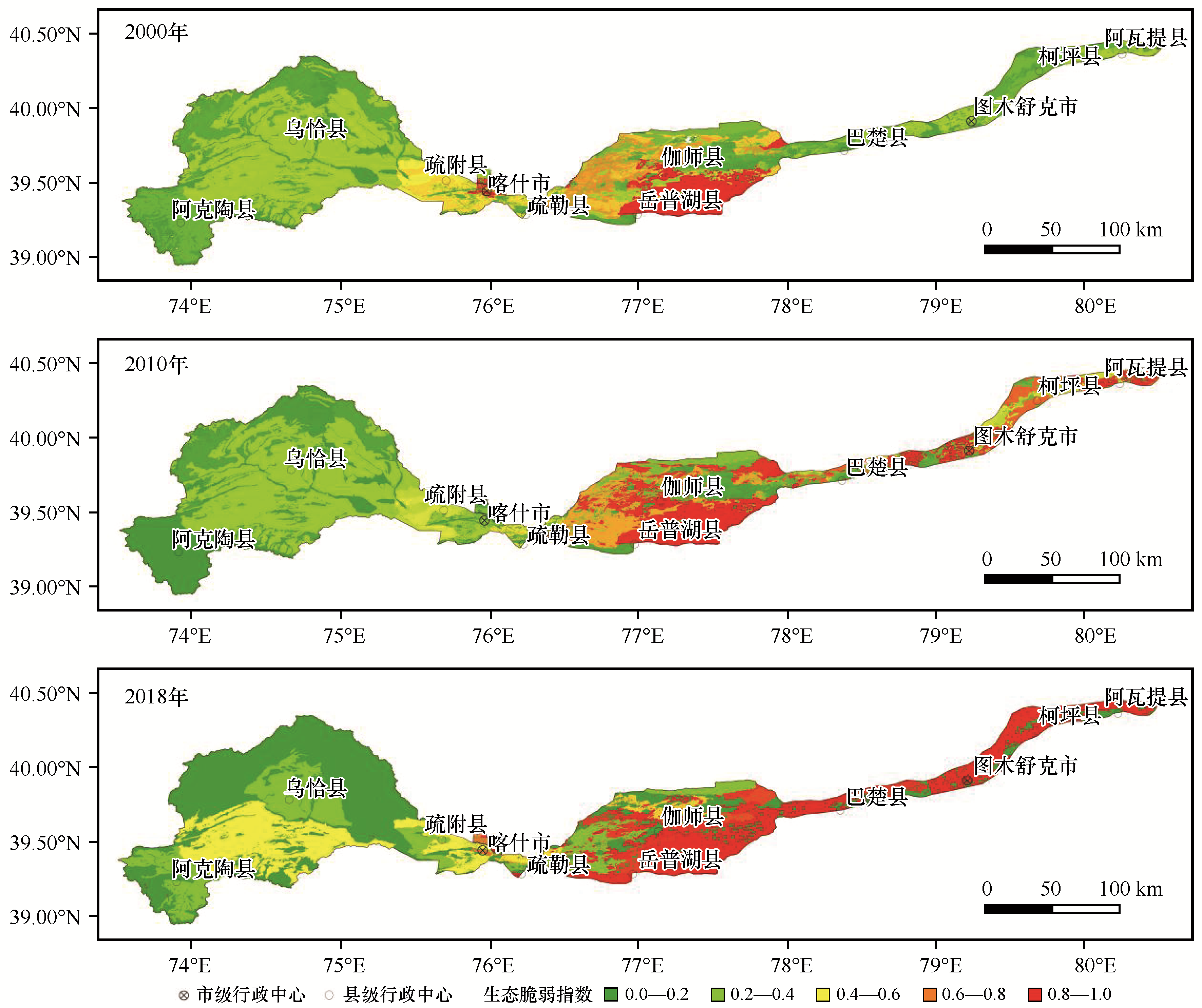
许学工,梁泽,周鑫.黄河三角洲陆海统筹可持续发展探讨[J].资源科学,2020,42(3):424-432.
|
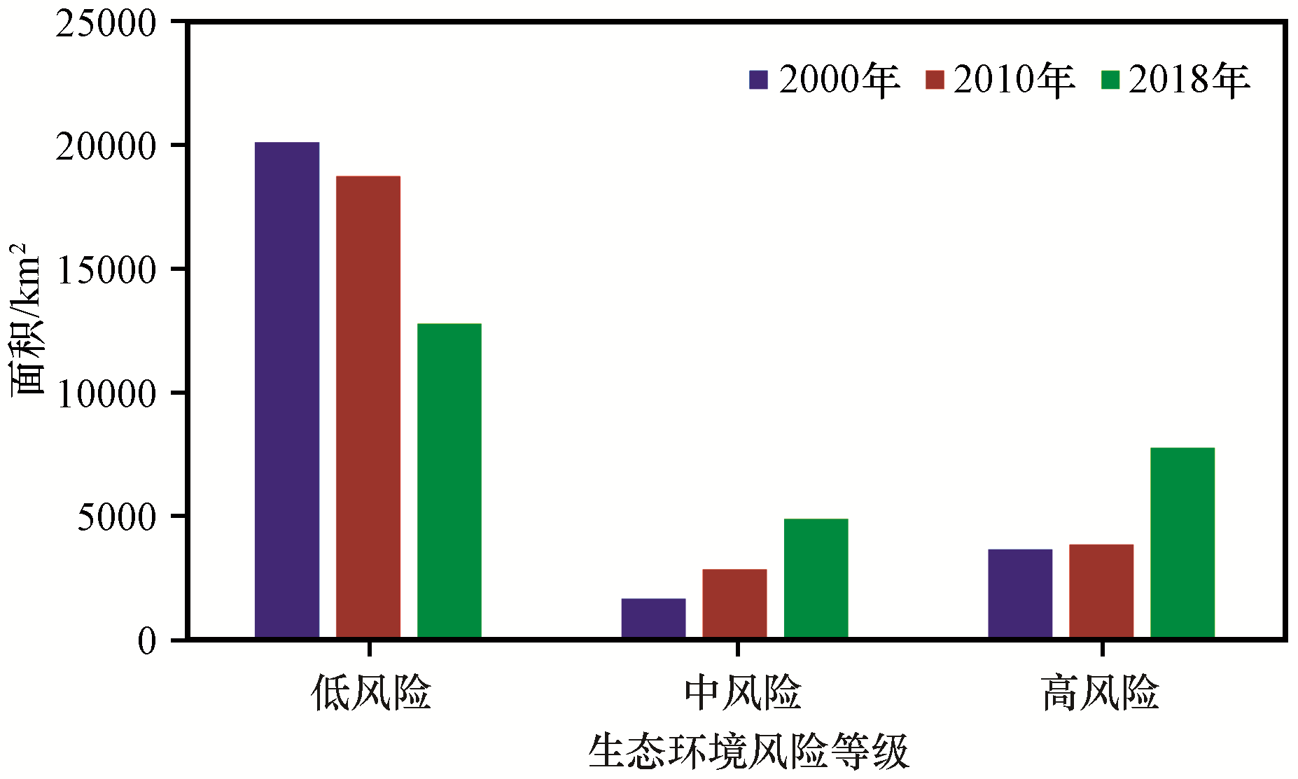
| 9 |
朗新文.喀什噶尔河流域水资源配置现状及对策探讨[J].陕西水利,2019(10):46-47.
|
| 10 |
黄劲柏,蒋海英.克孜河古河道现状及治理措施[J].河南水利与南水北调,2019,48(4):5-6.
|
| 11 |
蒋海英.克孜河渡槽槽身裂缝成因分析及处置措施[J].水利规划与设计,2019(4):114-117,153.
|
| 12 |
崔立新,李政海,张靖,等.克孜勒苏河流域植被覆盖空间格局及动态变化趋势分析[J].大连民族大学学报,2019,21(1):39-43.
|
| 13 |
Hu X,Ren H,Tansey K,et al.Agricultural drought monitoring using European Space Agency Sentinel 3A land surface temperature and normalized difference vegetation index imageries[J].Agricultural and Forest Meteorology,2019,50(7):279-290.
|
| 14 |
Yi G,Sheng Z H,Qiang H,et al.Propagation thresholds of meteorological drought for triggering hydrological drought at various levels[J].Science of the Total Environment,2020,712(7):1236-1248.
|
| 15 |
Wu F,Feng B.A new approach to predict normalized difference vegetation index using time delay neural network in the arid and semiarid grassland[J].International Journal of Remote Sensing,2019,40(23):146-153.
|
| 16 |
张学玲,张莹,牛德奎,等.基于TM NDVI的武功山山地草甸植被覆盖度时空变化研究[J].生态学报,2018,38(7):2414-2424.
|
| 17 |
程苗苗,江洪,陈健,等.基于Landsat数据的新疆和田地区植被覆盖变化研究[J].安徽农业科学,2009,37(3):1239-1250.
|
| 18 |
谢高地,张彩霞.基于单位面积价值当量因子的生态系统服务价值化方法改进[J].自然资源学报,2015,30(8):1243-1254.
|
| 19 |
何宝忠,丁建丽,张喆,等.新疆植被覆盖度趋势演变实验性分析[J].地理学报,2016,71(11):1948-1966.
|
| 20 |
布瑶.基于模糊综合评价和主成分分析的水资源承载力评价研究[D].西安:西安科技大学,2019.
|
| 21 |
康爱红.基于主成分分析的城市水资源分析及优化配置[D].河北邯郸:河北工程大学,2019.
|
| 22 |
姚昆,周兵,李小菊,等.基于AHP-PCA熵权模型的大渡河流域中上游地区生态环境脆弱性评价[J].水土保持研究,2019,26(5):265-271.
|
| 23 |
石惠春,何剑,刘伟.石羊河流域生态脆弱性评价研究[J].资源开发与市场,2012,28(11):1020-1024.
|
| 24 |
许学工,颜磊,徐丽芬,等.中国自然灾害生态风险评价[J].北京大学学报(自然科学版),2011,47(5):901-908.
|
| 25 |
陈忠升,陈亚宁,李卫红,等.新疆和田河流域土地利用及其生态服务价值变化[J].干旱区研究,2009,26(6):832-839.
|
| 26 |
陈荟竹,刘希林.广东省热带气旋、雨涝灾害和地质灾害生态风险评价(Ⅱ)[J].生态环境学报,2018,27(11):2047-2056.
|
| 27 |
贡璐,吕光辉,丁建丽,等.塔里木河上游土地利用变化中的生态价值损益分析[J].生态学杂志,2006(5):526-530.
|
| 28 |
何莎莎,李欣,何春龙,等.基于土地利用变化的扬州市广陵区景观生态风险评价[J].南京师大学报(自然科学版),2019,42(1):139-148.
|
| 29 |
徐露.四川省农业景观生态风险评价研究[J].中国农业资源与区划,2019,40(1):48-52.
|
| 30 |
Egbueri Johnbosco C,Enyigwe M T.Pollution and ecological risk assessment of potentially toxic elements in natural waters from the ameka metallogenic district in Southeastern Nigeria[J]. Taylor & Francis,2020,53(17):1-28.
|
| 31 |
张雅洲,谢小平.基于RS和GIS的南四湖生态风险评价[J].生态学报,2015,35(5):1371-1377.
|
 ), 张青青1(

 甘公网安备 62010202000688号