中国沙漠 ›› 2023, Vol. 43 ›› Issue (3): 230-242.DOI: 10.7522/j.issn.1000-694X.2022.00129
• • 上一篇
李森( ), 颜长珍
收稿日期:2022-09-02
修回日期:2022-10-24
出版日期:2023-05-20
发布日期:2023-05-31
作者简介:李森(1985—),男,山东潍坊人,高级工程师,研究方向为沙漠化/绿洲化监测。E-mail: lisen@lzb.ac.cn
基金资助:
Sen Li(), Changzhen Yan
Received:2022-09-02
Revised:2022-10-24
Online:2023-05-20
Published:2023-05-31
摘要:
生产兼具绿洲独特性和结构特点的绿洲专题数据是目前绿洲学研究亟待解决的关键基础性问题。以河西内陆河流域为研究区,在构建绿洲生态系统的二级分类体系基础上,结合ChinaCover数据和Landsat NDVI影像,利用面向对象随机森林分类和叠加分析方法,完成1975—2020年7期河西内陆河流域绿洲土地结构数据的制图。结果表明:(1)基于ChinaCover数据集的绿洲结构数据制图方法可以快速准确地生产出绿洲专题数据;(2)绿洲生态系统一级类型总体精度为96.17%,二级类型精度为82.64%~92.99%,制图精度明显高于现有土地覆被产品;(3)2020年河西内陆河流域绿洲占研究区比例为8.97%,一级类型以人工绿洲为主,二级类型以耕地和草地为主;(4)近45年河西内陆河流域人工绿洲呈持续扩张趋势,荒漠-绿洲过渡带呈萎缩趋势,自然绿洲呈先萎缩后扩张趋势;人工绿洲的扩张主要是耕地和建设用地的增加,而过渡带和自然绿洲的萎缩主要是草地减少。
中图分类号:
李森, 颜长珍. 基于ChinaCover数据集的绿洲结构数据制图——以河西内陆河流域为例[J]. 中国沙漠, 2023, 43(3): 230-242.
Sen Li, Changzhen Yan. Mapping oasis structure data based on ChinaCover dataset: a case study of Hexi Inland River Basin[J]. Journal of Desert Research, 2023, 43(3): 230-242.
| 数据集名称 | 发布单位 | 时间 | 分辨率 | 卫星数据源 | 参考文献 |
|---|---|---|---|---|---|
| IGBP DISCover | 国际地圈生物圈计划数据和信息系统 | 1992—1993年 | 1 km | NOAA AVHRR | [ |
| UMD | 马里兰大学 | 1992—1993年 | 1 km | NOAA AVHRR | [ |
| GLC 2000 | 欧洲委员会联合研究中心(JRC) | 2000年 | 1 km | SPOT VGT | [ |
| MOD12Q1 and MCD12Q1 | 美国波士顿大学 | 2001年至今 | 500/1 000 m | Terra and Aqua | [ |
| GlobCover | 欧洲航天局 | 2005—2006/2009年 | 300 m | ENVISAT MERIS | [ |
| CCI-LC | 欧洲航天局 | 2000/2005/2010年 | 300 m | ENVISAT MERIS | [ |
| GLCNMO | 全球制图国际指导委员会 | 2003/2008年 | 500 m | Terra and Aqua | [ |
| FROM-GLC | 清华大学 | 1984—2011年 | 30 m/10 m | Landsat/Sentinel-2 | [ |
| Esri 10-Meter Land Cover | Esri | 2017—2021年 | 10 m | Sentinel-2 | [ |
| Globeland30 | 国家测绘中心 | 2000/2010/2020年 | 30 m | Landsat、环境星、高分一号 | [ |
表1 10个全球土地覆被数据集的基本参数
Table 1 Basic parameters of ten global land cover datasets
| 数据集名称 | 发布单位 | 时间 | 分辨率 | 卫星数据源 | 参考文献 |
|---|---|---|---|---|---|
| IGBP DISCover | 国际地圈生物圈计划数据和信息系统 | 1992—1993年 | 1 km | NOAA AVHRR | [ |
| UMD | 马里兰大学 | 1992—1993年 | 1 km | NOAA AVHRR | [ |
| GLC 2000 | 欧洲委员会联合研究中心(JRC) | 2000年 | 1 km | SPOT VGT | [ |
| MOD12Q1 and MCD12Q1 | 美国波士顿大学 | 2001年至今 | 500/1 000 m | Terra and Aqua | [ |
| GlobCover | 欧洲航天局 | 2005—2006/2009年 | 300 m | ENVISAT MERIS | [ |
| CCI-LC | 欧洲航天局 | 2000/2005/2010年 | 300 m | ENVISAT MERIS | [ |
| GLCNMO | 全球制图国际指导委员会 | 2003/2008年 | 500 m | Terra and Aqua | [ |
| FROM-GLC | 清华大学 | 1984—2011年 | 30 m/10 m | Landsat/Sentinel-2 | [ |
| Esri 10-Meter Land Cover | Esri | 2017—2021年 | 10 m | Sentinel-2 | [ |
| Globeland30 | 国家测绘中心 | 2000/2010/2020年 | 30 m | Landsat、环境星、高分一号 | [ |
| 序号 | Ⅰ级分类 | 代码 | Ⅱ级分类 | 指 标 |
|---|---|---|---|---|
| 1 | 林地 | 101 | 常绿阔叶林 | H=3~30 m,C≥0.2,常绿,阔叶 |
| 102 | 落叶阔叶林 | H=3~30 m,C≥0.2,落叶,阔叶 | ||
| 103 | 常绿针叶林 | H=3~30 m,C≥0.2,常绿,针叶 | ||
| 104 | 落叶针叶林 | H=3~30 m,C≥0.2,落叶,针叶 | ||
| 105 | 针阔混交林 | H=3~30 m,C≥0.2,25%<F<75% | ||
| 106 | 常绿阔叶灌丛 | H=0.3~5 m,C≥0.2,常绿,阔叶 | ||
| 107 | 落叶阔叶灌丛 | H=0.3~5 m,C≥0.2,落叶,阔叶 | ||
| 108 | 常绿针叶灌丛 | H=0.3~5 m,C≥0.2,常绿,针叶 | ||
| 109 | 稀疏林 | H=3~30 m,C=0.04~0.2 | ||
| 110 | 稀疏灌丛 | H=0.3~5 m,C=0.04~0.2 | ||
| 111 | 乔木园地 | 人工植被,H=3~30 m,C≥0.2 | ||
| 112 | 灌木园地 | 人工植被,H=0.3~5 m,C≥0.2 | ||
| 113 | 乔木绿地 | 人工植被,人工表面周围,H=3~30 m,C≥0.2 | ||
| 114 | 灌木绿地 | 人工植被,人工表面周围,H=0.3~5 m,C≥0.2 | ||
| 2 | 草地 | 201 | 温性草原 | K<1,H=0.03~3 m,C≥0.2 |
| 202 | 高寒草原 | K<1,H=0.03~3 m,C≥0.2,T<1 300,海拔>3 200 m | ||
| 203 | 温性草甸 | K≥1,土壤湿润,H=0.03~3 m,C≥0.2 | ||
| 204 | 高寒草甸 | K≥1,土壤湿润,H=0.03~3 m,C≥0.2,T<2 300,海拔>3 200 m | ||
| 205 | 草丛 | K≥1,H=0.03~3 m,C≥0.2 | ||
| 206 | 稀疏草地 | H=0.03~3 m,C =0.04~0.2 | ||
| 207 | 草本绿地 | 人工植被,人工表面周围,H=0.03~3 m,C≥0.2 | ||
| 3 | 耕地 | 301 | 水田 | 人工植被,土地扰动,水生作物,收割过程 |
| 302 | 旱地 | 人工植被,土地扰动,旱生作物,收割过程 | ||
| 4 | 湿地 | 401 | 乔木湿地 | W>2或湿土,H=3~30 m,C≥0.2 |
| 402 | 灌木湿地 | W>2或湿土,H=0.3~5 m,C≥0.2 | ||
| 403 | 草本湿地 | W>2或湿土,H=0.03~3 m,C≥0.2 | ||
| 404 | 湖泊 | 自然水面,静止 | ||
| 405 | 水库/坑塘 | 人工水面,静止 沿海晒盐场地 | ||
| 406 | 河流 | 自然水面,流动 | ||
| 407 | 运河/水渠 | 人工水面,流动 | ||
| 5 | 人工表面 | 501 | 建设用地 | 人工硬表面,包括居住地和工业用地 |
| 502 | 交通用地 | 人工硬表面,线状特征 | ||
| 503 | 采矿场 | 人工挖掘表面 | ||
| 6 | 其他 | 601 | 苔藓/地衣 | 自然,苔藓或地衣覆盖 |
| 602 | 裸岩 | 自然,坚硬表面,石质,C <0.04 | ||
| 603 | 戈壁 | 自然,砾石表面,砾漠,C <0.04 | ||
| 604 | 裸土 | 自然,松散表面,壤质,C <0.04 | ||
| 605 | 沙漠 | 自然,松散表面,沙质,C<0.04 | ||
| 606 | 盐碱地 | 自然,松散表面,高盐分 | ||
| 607 | 冰川/永久积雪 | 自然,水的固态 |
表2 “面向全国生态系统碳收支”分类系统
Table 2 Classification system of "carbon budget for the national ecosystem"
| 序号 | Ⅰ级分类 | 代码 | Ⅱ级分类 | 指 标 |
|---|---|---|---|---|
| 1 | 林地 | 101 | 常绿阔叶林 | H=3~30 m,C≥0.2,常绿,阔叶 |
| 102 | 落叶阔叶林 | H=3~30 m,C≥0.2,落叶,阔叶 | ||
| 103 | 常绿针叶林 | H=3~30 m,C≥0.2,常绿,针叶 | ||
| 104 | 落叶针叶林 | H=3~30 m,C≥0.2,落叶,针叶 | ||
| 105 | 针阔混交林 | H=3~30 m,C≥0.2,25%<F<75% | ||
| 106 | 常绿阔叶灌丛 | H=0.3~5 m,C≥0.2,常绿,阔叶 | ||
| 107 | 落叶阔叶灌丛 | H=0.3~5 m,C≥0.2,落叶,阔叶 | ||
| 108 | 常绿针叶灌丛 | H=0.3~5 m,C≥0.2,常绿,针叶 | ||
| 109 | 稀疏林 | H=3~30 m,C=0.04~0.2 | ||
| 110 | 稀疏灌丛 | H=0.3~5 m,C=0.04~0.2 | ||
| 111 | 乔木园地 | 人工植被,H=3~30 m,C≥0.2 | ||
| 112 | 灌木园地 | 人工植被,H=0.3~5 m,C≥0.2 | ||
| 113 | 乔木绿地 | 人工植被,人工表面周围,H=3~30 m,C≥0.2 | ||
| 114 | 灌木绿地 | 人工植被,人工表面周围,H=0.3~5 m,C≥0.2 | ||
| 2 | 草地 | 201 | 温性草原 | K<1,H=0.03~3 m,C≥0.2 |
| 202 | 高寒草原 | K<1,H=0.03~3 m,C≥0.2,T<1 300,海拔>3 200 m | ||
| 203 | 温性草甸 | K≥1,土壤湿润,H=0.03~3 m,C≥0.2 | ||
| 204 | 高寒草甸 | K≥1,土壤湿润,H=0.03~3 m,C≥0.2,T<2 300,海拔>3 200 m | ||
| 205 | 草丛 | K≥1,H=0.03~3 m,C≥0.2 | ||
| 206 | 稀疏草地 | H=0.03~3 m,C =0.04~0.2 | ||
| 207 | 草本绿地 | 人工植被,人工表面周围,H=0.03~3 m,C≥0.2 | ||
| 3 | 耕地 | 301 | 水田 | 人工植被,土地扰动,水生作物,收割过程 |
| 302 | 旱地 | 人工植被,土地扰动,旱生作物,收割过程 | ||
| 4 | 湿地 | 401 | 乔木湿地 | W>2或湿土,H=3~30 m,C≥0.2 |
| 402 | 灌木湿地 | W>2或湿土,H=0.3~5 m,C≥0.2 | ||
| 403 | 草本湿地 | W>2或湿土,H=0.03~3 m,C≥0.2 | ||
| 404 | 湖泊 | 自然水面,静止 | ||
| 405 | 水库/坑塘 | 人工水面,静止 沿海晒盐场地 | ||
| 406 | 河流 | 自然水面,流动 | ||
| 407 | 运河/水渠 | 人工水面,流动 | ||
| 5 | 人工表面 | 501 | 建设用地 | 人工硬表面,包括居住地和工业用地 |
| 502 | 交通用地 | 人工硬表面,线状特征 | ||
| 503 | 采矿场 | 人工挖掘表面 | ||
| 6 | 其他 | 601 | 苔藓/地衣 | 自然,苔藓或地衣覆盖 |
| 602 | 裸岩 | 自然,坚硬表面,石质,C <0.04 | ||
| 603 | 戈壁 | 自然,砾石表面,砾漠,C <0.04 | ||
| 604 | 裸土 | 自然,松散表面,壤质,C <0.04 | ||
| 605 | 沙漠 | 自然,松散表面,沙质,C<0.04 | ||
| 606 | 盐碱地 | 自然,松散表面,高盐分 | ||
| 607 | 冰川/永久积雪 | 自然,水的固态 |
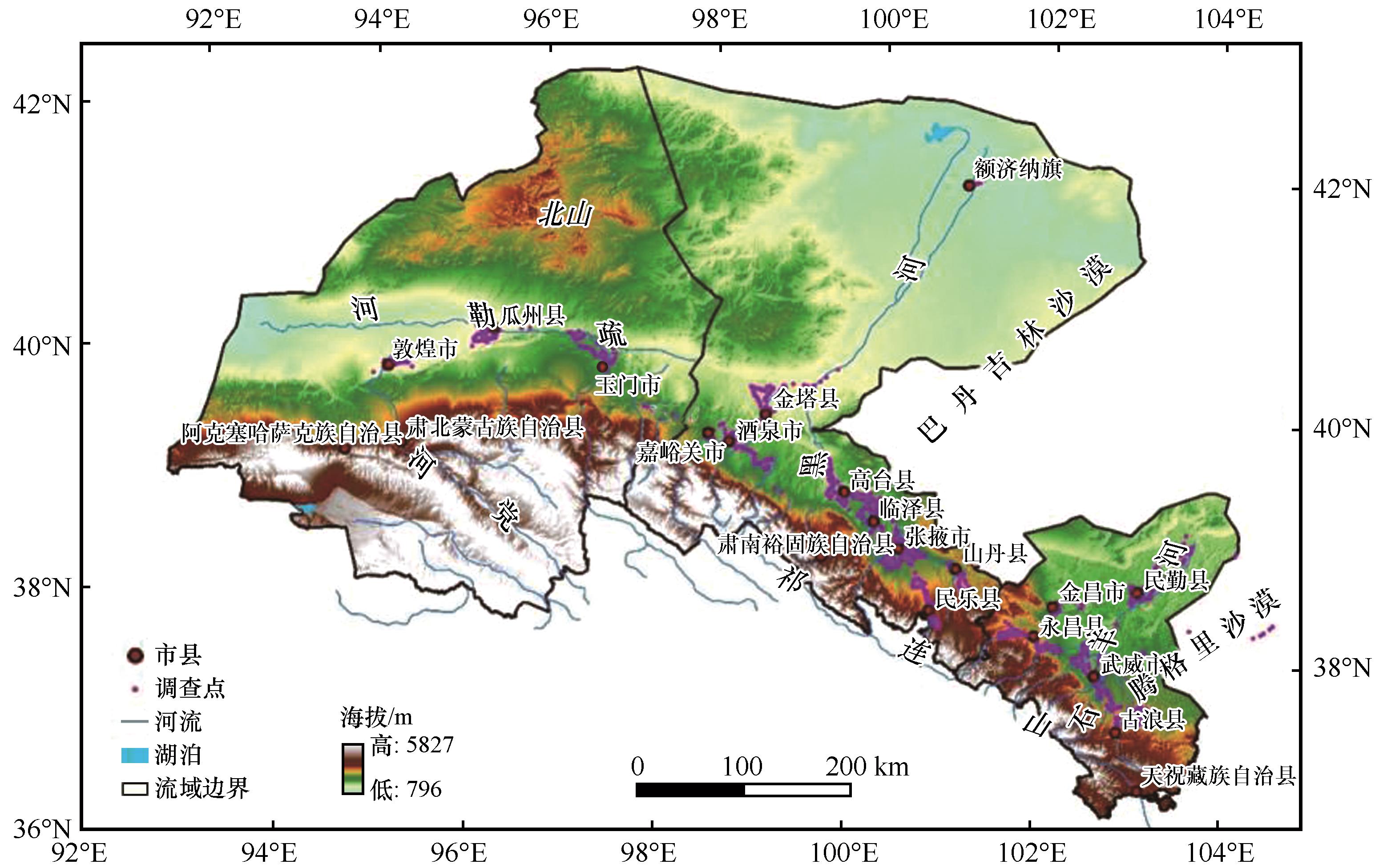
图1 研究区位置
Fig. 1 The location of the study area
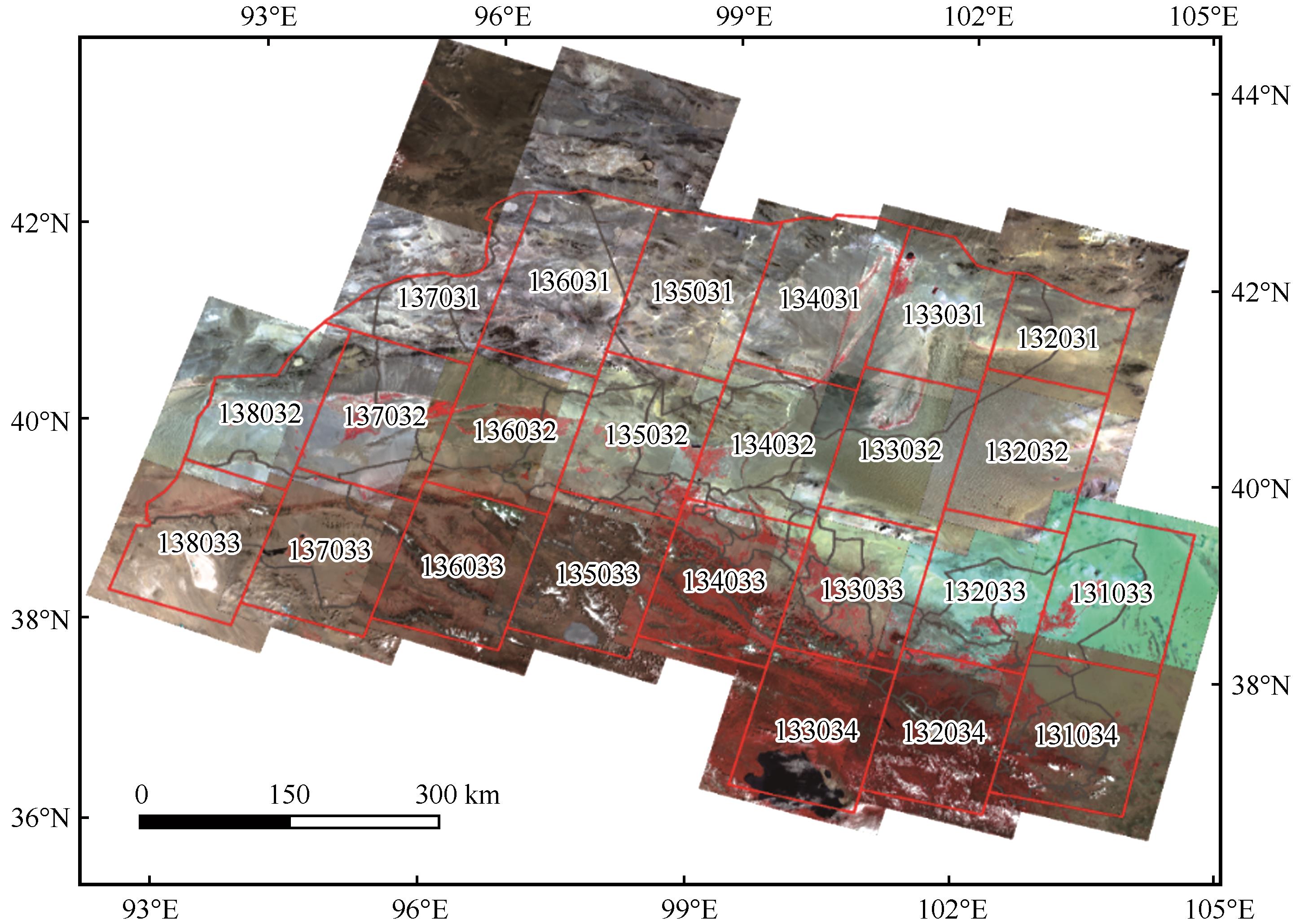
图2 河西内陆河流域Landsat轨道号及2020年OLI影像
Fig. 2 The Landsat track number and 2020 OLI image in Hexi inland river basin
| 一级类型 | 特征描述及分布 | 二级类型 | 特征描述及分布 |
|---|---|---|---|
| 人工绿洲 | 位于荒漠基质背景下,植被生产力明显高于周围,耕地和建设用地是其主要土地覆被类型,绿洲外围和耕地周围有明显的条带状防护林草带 | 林地 | 以人工防护林为主,主要是防护人工绿洲遭到风沙侵害,与耕地或建设用地这样的典型类型相邻 |
| 草地 | 分布在绿洲内部,斑块较小,一般属于未开垦地或者撂荒地 | ||
| 耕地 | 人工绿洲的主体,呈规则的块状 | ||
| 湿地 | 人工绿洲内的坑塘、人工湿地、河渠等 | ||
| 建设用地 | 人工绿洲内的农村居民点、城镇用地及道路设施 | ||
| 未利用地 | 人工绿洲内斑块较小的未利用地,一般多为裸土、盐碱地等 | ||
| 荒漠-绿洲 过渡带 | 由于自然绿洲与荒漠没有明显的植被覆盖度降低的梯度,本研究中过渡带指的是人工绿洲和荒漠的中间地带。因此主要分布在荒漠和人工绿洲之间,以天然或半人工灌草为主,植被生产力明显低于人工绿洲,高于荒漠,通常植被覆盖度高于14% | 林地 | 分布在人工绿洲的外围,以天然或半人工林灌为主,有少量的人类活动痕迹 |
| 草地 | 分布在人工绿洲的外围,以天然或半人工草地为主,有少量的人类活动痕迹 | ||
| 湿地 | 分布在人工绿洲的外围,以天然湿地为主,遭受少量的人类活动影响 | ||
| 未利用地 | 过渡带内斑块较小的未利用地,一般不与山地-荒漠系统连接,多为裸土、盐碱地等 | ||
| 自然绿洲 | 主要分布在下游尾闾附近,主要是无人工干扰的林草灌等类型,有的具有一定面积的天然湿地。小部分位于河流两边,属于河岸林 | 林地 | 分布在流域下游或河流两侧,与人工绿洲的位置关系是在人工绿洲的下方向,一般是天然林灌,极少受到人类干扰 |
| 草地 | 分布在流域下游或河流两侧,与人工绿洲的位置关系是在人工绿洲的下方向,一般是天然旱生草地,极少受到人类干扰 | ||
| 湿地 | 分布在流域下游河流和尾闾湖泊及周围湿地 | ||
| 未利用地 | 自然绿洲内斑块较小的未利用地,一般不与山地-荒漠系统连接,多为裸土、盐碱地等 |
表3 基于ChinaCover数据集的绿洲生态系统分类体系
Table 3 Oasis ecosystem classification system based on ChinaCover data set
| 一级类型 | 特征描述及分布 | 二级类型 | 特征描述及分布 |
|---|---|---|---|
| 人工绿洲 | 位于荒漠基质背景下,植被生产力明显高于周围,耕地和建设用地是其主要土地覆被类型,绿洲外围和耕地周围有明显的条带状防护林草带 | 林地 | 以人工防护林为主,主要是防护人工绿洲遭到风沙侵害,与耕地或建设用地这样的典型类型相邻 |
| 草地 | 分布在绿洲内部,斑块较小,一般属于未开垦地或者撂荒地 | ||
| 耕地 | 人工绿洲的主体,呈规则的块状 | ||
| 湿地 | 人工绿洲内的坑塘、人工湿地、河渠等 | ||
| 建设用地 | 人工绿洲内的农村居民点、城镇用地及道路设施 | ||
| 未利用地 | 人工绿洲内斑块较小的未利用地,一般多为裸土、盐碱地等 | ||
| 荒漠-绿洲 过渡带 | 由于自然绿洲与荒漠没有明显的植被覆盖度降低的梯度,本研究中过渡带指的是人工绿洲和荒漠的中间地带。因此主要分布在荒漠和人工绿洲之间,以天然或半人工灌草为主,植被生产力明显低于人工绿洲,高于荒漠,通常植被覆盖度高于14% | 林地 | 分布在人工绿洲的外围,以天然或半人工林灌为主,有少量的人类活动痕迹 |
| 草地 | 分布在人工绿洲的外围,以天然或半人工草地为主,有少量的人类活动痕迹 | ||
| 湿地 | 分布在人工绿洲的外围,以天然湿地为主,遭受少量的人类活动影响 | ||
| 未利用地 | 过渡带内斑块较小的未利用地,一般不与山地-荒漠系统连接,多为裸土、盐碱地等 | ||
| 自然绿洲 | 主要分布在下游尾闾附近,主要是无人工干扰的林草灌等类型,有的具有一定面积的天然湿地。小部分位于河流两边,属于河岸林 | 林地 | 分布在流域下游或河流两侧,与人工绿洲的位置关系是在人工绿洲的下方向,一般是天然林灌,极少受到人类干扰 |
| 草地 | 分布在流域下游或河流两侧,与人工绿洲的位置关系是在人工绿洲的下方向,一般是天然旱生草地,极少受到人类干扰 | ||
| 湿地 | 分布在流域下游河流和尾闾湖泊及周围湿地 | ||
| 未利用地 | 自然绿洲内斑块较小的未利用地,一般不与山地-荒漠系统连接,多为裸土、盐碱地等 |
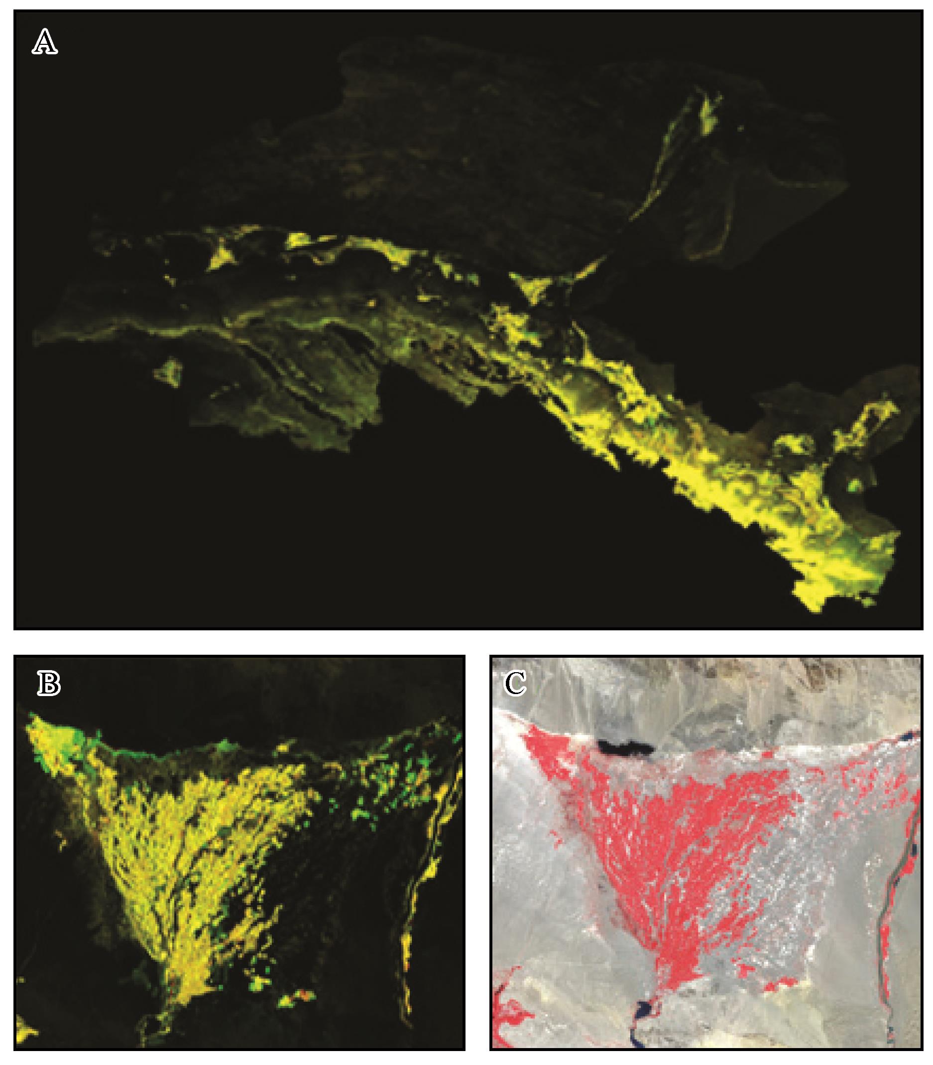
图3 2015—2020年研究区植被覆盖度变化监测显示A:研究区图层叠加显示图;B:金塔绿洲2015—2020年变化细节图,由于近几年该区域大力发展戈壁农业,因此图中显示绿洲扩展区域为绿色;C:金塔绿洲2015年假彩色影像显示图
Fig. 3 Monitoring display of vegetation coverage changes in the study area during 2015-2020
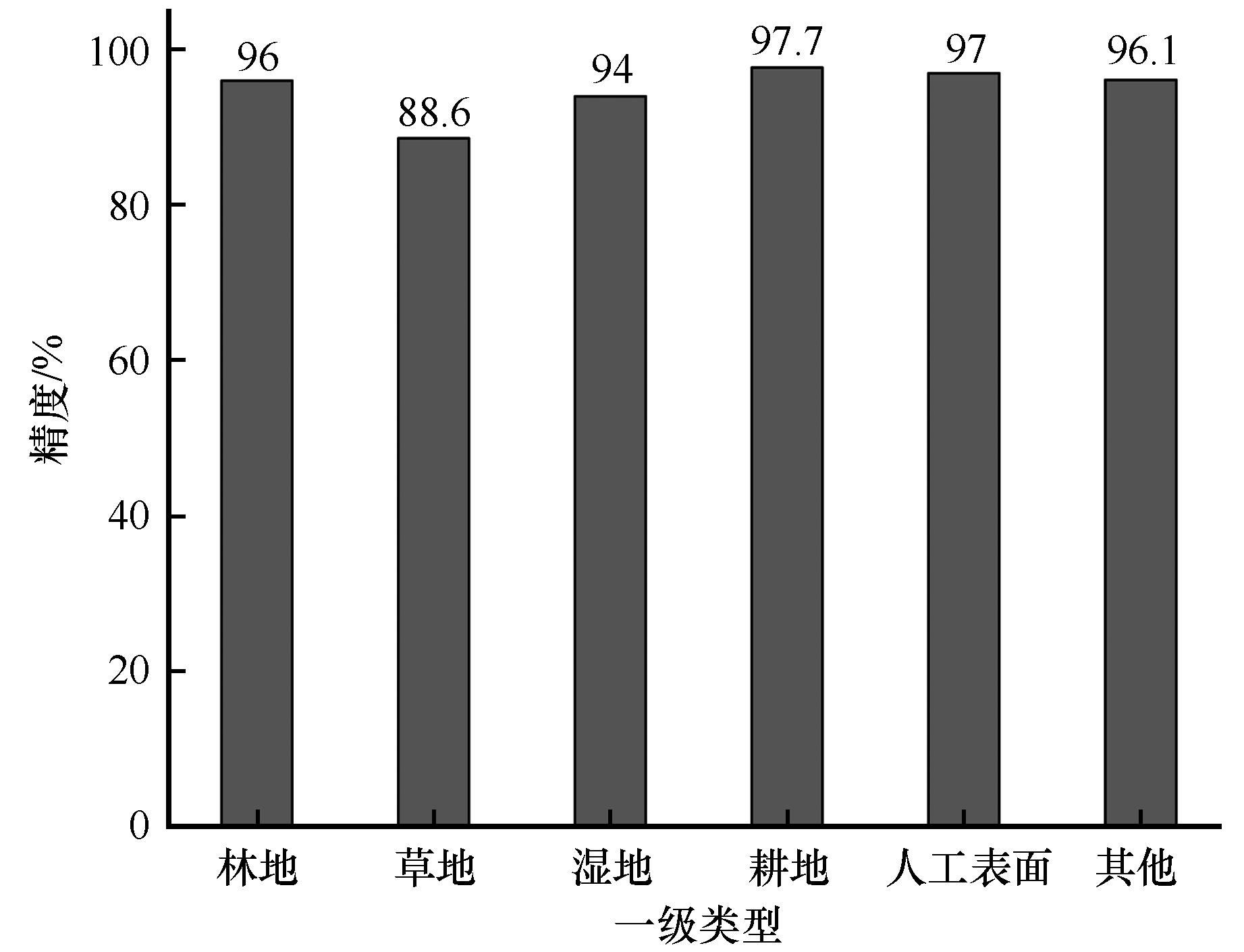
图4 ChinaCover产品中北方温带干旱区土地覆被一级类型精度[46]
Fig. 4 Accuracy of the first-level type of land cover in the northern temperate arid area of ChinaCover product[46]
| 人工绿洲 | 自然绿洲 | 过渡带 | 山地荒漠 | 合计 | |
|---|---|---|---|---|---|
| 人工绿洲 | 669 | 3 | 5 | 1 | 678 |
| 自然绿洲 | 5 | 127 | 2 | 2 | 136 |
| 过渡带 | 8 | 7 | 83 | 5 | 103 |
| 山地荒漠 | 0 | 3 | 4 | 250 | 257 |
| 合计 | 682 | 140 | 94 | 258 | 1 174 |
| 用户精度 | 98.09% | 90.71% | 88.30% | 96.90% | |
| 制图精度 | 98.67% | 93.38% | 80.58% | 97.28% | |
| 总体精度 | 96.17% | ||||
| Kappa系数 | 0.936 |
表4 2020年绿洲生态系统一级类型分类结果混淆矩阵
Table 4 Confusion matrix for the classification results of the first-level types of oasis ecosystems in 2020
| 人工绿洲 | 自然绿洲 | 过渡带 | 山地荒漠 | 合计 | |
|---|---|---|---|---|---|
| 人工绿洲 | 669 | 3 | 5 | 1 | 678 |
| 自然绿洲 | 5 | 127 | 2 | 2 | 136 |
| 过渡带 | 8 | 7 | 83 | 5 | 103 |
| 山地荒漠 | 0 | 3 | 4 | 250 | 257 |
| 合计 | 682 | 140 | 94 | 258 | 1 174 |
| 用户精度 | 98.09% | 90.71% | 88.30% | 96.90% | |
| 制图精度 | 98.67% | 93.38% | 80.58% | 97.28% | |
| 总体精度 | 96.17% | ||||
| Kappa系数 | 0.936 |
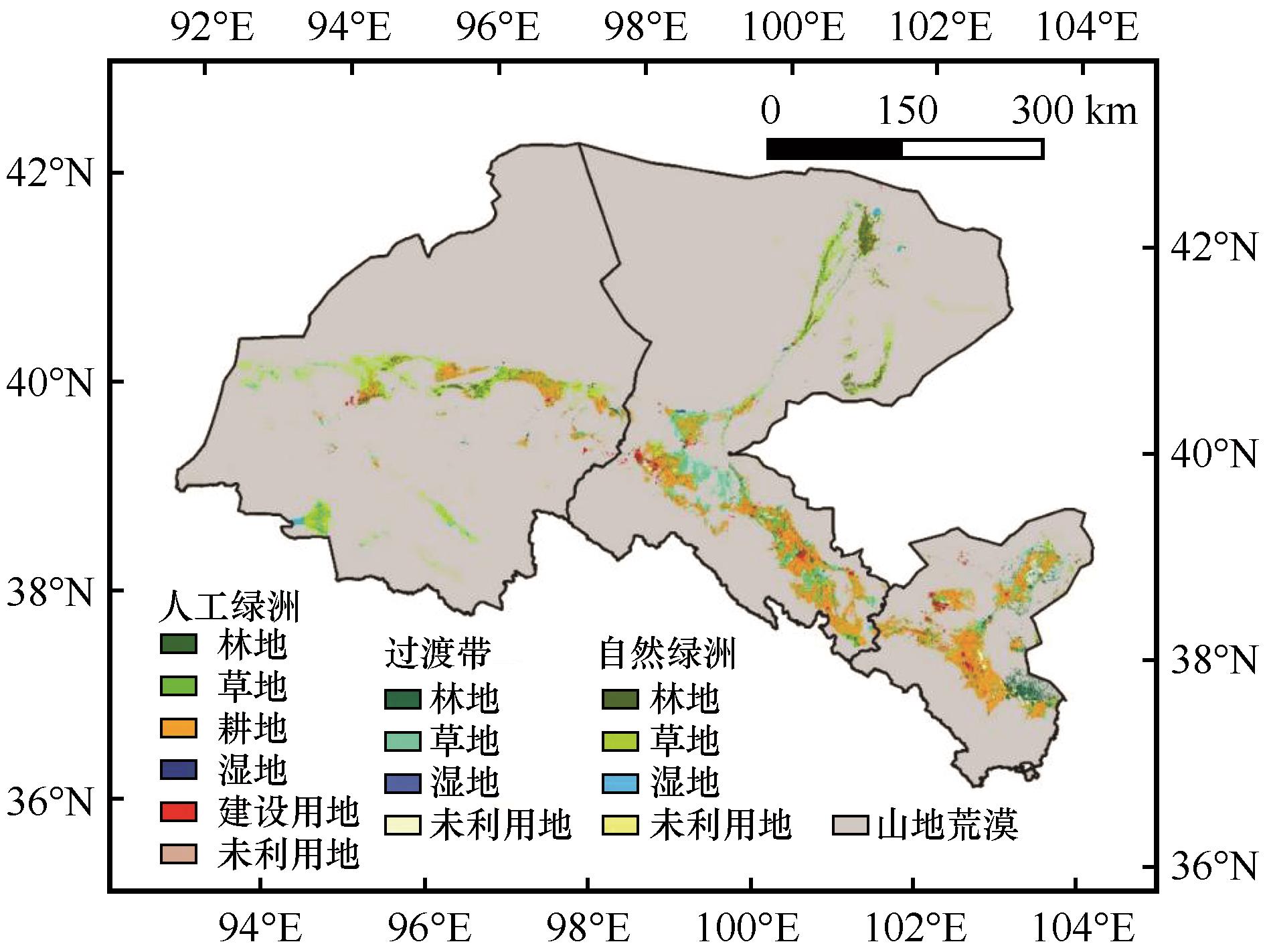
图5 河西内陆河流域绿洲空间分布现状(2020年)
Fig 5 Spatial distribution of oasis in the Hexi inland river basin in 2020
| 一级类型 | 二级类型 | 1975年 | 1990年 | 2000年 | 2005年 | 2010年 | 2015年 | 2020年 |
|---|---|---|---|---|---|---|---|---|
| 人工绿洲 | 林地 | 526.45 | 544.69 | 645.09 | 700.98 | 754.30 | 848.70 | 902.43 |
| 草地 | 884.14 | 857.88 | 993.51 | 1 012.52 | 1 148.02 | 1 231.31 | 1 186.39 | |
| 耕地 | 11 016.00 | 11 315.92 | 12 083.39 | 12 760.85 | 12 858.57 | 13 032.21 | 13 333.13 | |
| 湿地 | 138.11 | 150.33 | 152.84 | 165.48 | 188.77 | 207.11 | 207.24 | |
| 建设用地 | 1 128.45 | 1 167.65 | 1 172.63 | 1 257.22 | 1 324.50 | 1 617.21 | 1 712.99 | |
| 未利用地 | 293.08 | 227.54 | 221.55 | 210.29 | 213.01 | 273.82 | 280.39 | |
| 小计 | 13 986.21 | 14 264.00 | 15 269.01 | 16 107.35 | 16 487.16 | 17 210.35 | 17 622.57 | |
| 过渡带 | 林地 | 1 273.93 | 1 260.92 | 1 218.73 | 1 186.06 | 1 125.18 | 1 101.01 | 1 103.84 |
| 草地 | 4 026.42 | 3 976.08 | 3 535.31 | 3 372.20 | 3 306.82 | 3 102.80 | 2 974.67 | |
| 湿地 | 39.70 | 35.25 | 33.34 | 28.10 | 27.94 | 28.46 | 32.71 | |
| 未利用地 | 1 581.86 | 1 582.40 | 1 403.74 | 1 380.55 | 1 112.49 | 1 066.98 | 1 059.53 | |
| 小计 | 6 921.90 | 6 854.65 | 6 191.13 | 5 966.92 | 5 572.43 | 5 299.25 | 5 170.76 | |
| 自然绿洲 | 林地 | 1 613.55 | 1 615.79 | 1 600.01 | 1 586.13 | 1 582.54 | 1 548.26 | 1 573.78 |
| 草地 | 4 814.36 | 4 807.38 | 4 739.16 | 4 602.05 | 4 558.62 | 4 535.54 | 4 593.83 | |
| 湿地 | 550.13 | 518.90 | 517.26 | 594.06 | 600.93 | 727.34 | 722.43 | |
| 未利用地 | 407.38 | 386.97 | 382.58 | 393.27 | 337.22 | 387.80 | 388.34 | |
| 小计 | 7 385.43 | 7 329.04 | 7 239.01 | 7 175.51 | 7 079.31 | 7 198.94 | 7 278.38 | |
| 总计 | 28 293.55 | 28 447.69 | 28 699.15 | 29 249.77 | 29 138.90 | 29 708.55 | 30 071.71 | |
表5 1975—2020年绿洲土地覆被类型面积(km2 )
Table 5 Area of Oasis land cover types from 1975 to 2020 (km2 )
| 一级类型 | 二级类型 | 1975年 | 1990年 | 2000年 | 2005年 | 2010年 | 2015年 | 2020年 |
|---|---|---|---|---|---|---|---|---|
| 人工绿洲 | 林地 | 526.45 | 544.69 | 645.09 | 700.98 | 754.30 | 848.70 | 902.43 |
| 草地 | 884.14 | 857.88 | 993.51 | 1 012.52 | 1 148.02 | 1 231.31 | 1 186.39 | |
| 耕地 | 11 016.00 | 11 315.92 | 12 083.39 | 12 760.85 | 12 858.57 | 13 032.21 | 13 333.13 | |
| 湿地 | 138.11 | 150.33 | 152.84 | 165.48 | 188.77 | 207.11 | 207.24 | |
| 建设用地 | 1 128.45 | 1 167.65 | 1 172.63 | 1 257.22 | 1 324.50 | 1 617.21 | 1 712.99 | |
| 未利用地 | 293.08 | 227.54 | 221.55 | 210.29 | 213.01 | 273.82 | 280.39 | |
| 小计 | 13 986.21 | 14 264.00 | 15 269.01 | 16 107.35 | 16 487.16 | 17 210.35 | 17 622.57 | |
| 过渡带 | 林地 | 1 273.93 | 1 260.92 | 1 218.73 | 1 186.06 | 1 125.18 | 1 101.01 | 1 103.84 |
| 草地 | 4 026.42 | 3 976.08 | 3 535.31 | 3 372.20 | 3 306.82 | 3 102.80 | 2 974.67 | |
| 湿地 | 39.70 | 35.25 | 33.34 | 28.10 | 27.94 | 28.46 | 32.71 | |
| 未利用地 | 1 581.86 | 1 582.40 | 1 403.74 | 1 380.55 | 1 112.49 | 1 066.98 | 1 059.53 | |
| 小计 | 6 921.90 | 6 854.65 | 6 191.13 | 5 966.92 | 5 572.43 | 5 299.25 | 5 170.76 | |
| 自然绿洲 | 林地 | 1 613.55 | 1 615.79 | 1 600.01 | 1 586.13 | 1 582.54 | 1 548.26 | 1 573.78 |
| 草地 | 4 814.36 | 4 807.38 | 4 739.16 | 4 602.05 | 4 558.62 | 4 535.54 | 4 593.83 | |
| 湿地 | 550.13 | 518.90 | 517.26 | 594.06 | 600.93 | 727.34 | 722.43 | |
| 未利用地 | 407.38 | 386.97 | 382.58 | 393.27 | 337.22 | 387.80 | 388.34 | |
| 小计 | 7 385.43 | 7 329.04 | 7 239.01 | 7 175.51 | 7 079.31 | 7 198.94 | 7 278.38 | |
| 总计 | 28 293.55 | 28 447.69 | 28 699.15 | 29 249.77 | 29 138.90 | 29 708.55 | 30 071.71 | |
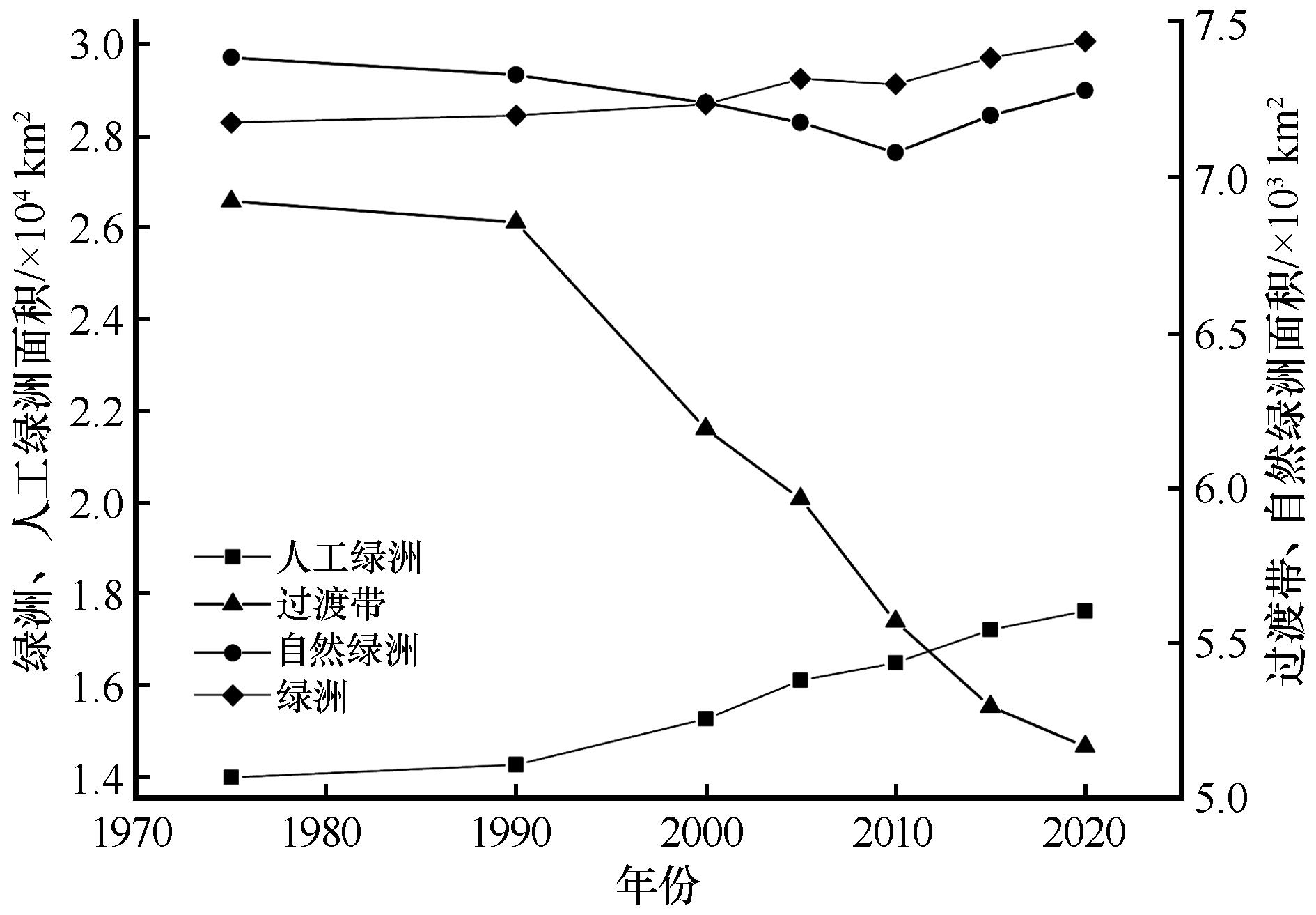
图6 1975—2020年河西内陆河流域绿洲面积变化
Fig. 6 Changes of oasis area in Hexi inland river basin from 1975 to 2020
| 类型 | FROM-GLC数据 | 本研究绿洲二级类数据 | ||
|---|---|---|---|---|
| 制图精度 | 用户精度 | 制图精度 | 用户精度 | |
| 农田 | 72.36% | 81.65% | 92.19% | 95.93% |
| 林地 | 14.29% | 57.14% | 87.04% | 90.38% |
| 草地 | 47.27% | 40.00% | 79.17% | 63.33% |
| 建设用地 | 0.00% | 0.00% | 100.00% | 100.00% |
| 湿地 | 94.74% | 85.71% | 94.74% | 100.00% |
| 未利用地 | 88.24% | 29.41% | 76.47% | 68.42% |
| 总体 | 60.08% | 89.33% | ||
| Kappa系数 | 0.439 | 0.845 | ||
表6 本数据产品与FROM-GLC数据精度对比
Table 6 The comparison of the accuracy on between this data product and FROM-GLC data
| 类型 | FROM-GLC数据 | 本研究绿洲二级类数据 | ||
|---|---|---|---|---|
| 制图精度 | 用户精度 | 制图精度 | 用户精度 | |
| 农田 | 72.36% | 81.65% | 92.19% | 95.93% |
| 林地 | 14.29% | 57.14% | 87.04% | 90.38% |
| 草地 | 47.27% | 40.00% | 79.17% | 63.33% |
| 建设用地 | 0.00% | 0.00% | 100.00% | 100.00% |
| 湿地 | 94.74% | 85.71% | 94.74% | 100.00% |
| 未利用地 | 88.24% | 29.41% | 76.47% | 68.42% |
| 总体 | 60.08% | 89.33% | ||
| Kappa系数 | 0.439 | 0.845 | ||
| 一级类型 | 二级类型 | 本数据 | oasis_wang | oasis_xie |
|---|---|---|---|---|
| 人工绿洲 | 林地 | 754.3 | 629.61 | — |
| 草地 | 1 148.02 | 786.2 | — | |
| 耕地 | 12 858.57 | 10 262.61 | — | |
| 湿地 | 188.77 | 301.54 | — | |
| 建设用地 | 1 324.5 | 1 395.94 | — | |
| 未利用地 | 213.01 | 208.15 | — | |
| 小计 | 16 487.16 | 13 584.05 | 14 410.73 |
表7 本数据人工绿洲与其他数据产品面积比较(2010年,km2 )
Table 7 Comparison of the area of artificial oases in our data with other data products (2010, Unit: km2 )
| 一级类型 | 二级类型 | 本数据 | oasis_wang | oasis_xie |
|---|---|---|---|---|
| 人工绿洲 | 林地 | 754.3 | 629.61 | — |
| 草地 | 1 148.02 | 786.2 | — | |
| 耕地 | 12 858.57 | 10 262.61 | — | |
| 湿地 | 188.77 | 301.54 | — | |
| 建设用地 | 1 324.5 | 1 395.94 | — | |
| 未利用地 | 213.01 | 208.15 | — | |
| 小计 | 16 487.16 | 13 584.05 | 14 410.73 |
| 1 | 申元村.拓展中国绿洲研究,促进干旱区域可持续发展[J].干旱区研究,2007(4):415. |
| 2 | 王涛.干旱区绿洲化、荒漠化研究的进展与趋势[J].中国沙漠,2009,29(1):1-9. |
| 3 | 赵文智,庄艳丽.中国干旱区绿洲稳定性研究[J].干旱区研究,2008(2):155-162. |
| 4 | 王玉洁,秦大河.气候变化及人类活动对西北干旱区水资源影响研究综述[J].气候变化研究进展,2017,13(5):483-493. |
| 5 | Jia B, Zhang Z, Ci L,et al.Oasis land-use dynamics and its influence on the oasis environment in Xinjiang,China[J].Journal of Arid Environments,2004,56(1):11-26. |
| 6 | 巩杰,谢余初,高彦净,等.1963-2009年金塔绿洲变化对绿洲景观格局的影响[J].生态学报,2015,35(3):603-612. |
| 7 | 王新源,刘世增,陈翔舜,等.河西走廊绿洲面积动态及其驱动因素[J].中国沙漠,2019,39(4):212-219. |
| 8 | Bie Q, Xie Y.The constraints and driving forces of oasis development in arid region:a case study of the Hexi Corridor in northwest China[J].Scientific Reports,2020,10:17708. |
| 9 | Xie Y, Bie Q, Lu H,et al.Spatio-temporal changes of oases in the Hexi Corridor over the past 30 years[J].Sustainability,2018,10:4489. |
| 10 | 卫娇娇.基于遥感的甘肃河西地区绿洲分布提取及时空变化分析[D].兰州:兰州大学,2016. |
| 11 | 李森,颜长珍.近20年来河西走廊人工绿洲演变及人为因素分析[J].干旱区资源与环境,2013,27(4):92-98. |
| 12 | 赵文智,杨荣,刘冰,等.中国绿洲化及其研究进展[J].中国沙漠,2016,36(1):1-5. |
| 13 | 陈曦,罗格平.干旱区绿洲生态研究及其进展[J].干旱区地理,2008(4):487-495. |
| 14 | 赵文智,常学礼.河西走廊水文过程变化对荒漠绿洲过渡带NDVI的影响[J].中国科学:地球科学,2014,44(7):1561-1571. |
| 15 | 武磊,李常斌,王刘明,等.基于ESA-LUC和MODIS-NDVI的西北干旱荒漠-绿洲体系分类阈值及应用[J].中国沙漠,2020,40(6):139-150. |
| 16 | Foley J A, DeFries R, Asner G P,et al.Global consequences of land use[J].Science,2005,309(5734):570-574. |
| 17 | Running S W.Ecosystem disturbance,carbon,and climate[J].Science,2008,321(5889):652-653. |
| 18 | Gong P, Wang J, Yu L,et al.Finer resolution observation and monitoring of global land cover:first mapping results with Landsat TM and ETM+ data[J].International Journal of Remote Sensing,2013,34(7):2607-2654. |
| 19 | Zhang Z, Wang X, Zhao X,et al.A 2010 update of National Land Use/Cover Database of China at 1∶100000 scale using medium spatial resolution satellite images[J].Remote Sensing of Environment,2014,149:142-154. |
| 20 | Yang Y, Xiao P, Feng X,et al.Accuracy assessment of seven global land cover datasets over China[J].ISPRS Journal of Photogrammetry and Remote Sensing,2017,125:156-173. |
| 21 | Chen J, Zhu X, Imura H,et al.Consistency of accuracy assessment indices for soft classification:Simulation analysis [J].ISPRS Journal of Photogrammetry and Remote Sensing,2010,65:156-164. |
| 22 | Fei C, Jun C, Hao W,et al.A landscape shape index-based sampling approach for land cover accuracy assessment[J].Science China (Earth Sciences),2016,59(12):2263-2274. |
| 23 | Loveland T R, Belward A S.The IGBP-DIS global 1 km land cover data set,DISCover:first results[J].International Journal of Remote Sensing,1997,18(15):3289-3295. |
| 24 | Loveland T R, Reed B C, Brown J F,et al.Development of a global land cover characteristics database and IGBP DISCover from 1 km AVHRR data[J].International Journal of Remote Sensing,2000,21(6/7):1303-1330. |
| 25 | Hansen M C, Defries R S, Townshend J R G,et al.Global land cover classification at 1 km spatial resolution using a classification tree approach[J].International Journal of Remote Sensing,2000,21(6/7):1331-1364. |
| 26 | Bartholome E, Belward A S.GLC2000:a new approach to global land cover mapping from Earth observation data[J].International Journal of Remote Sensing,2005,26(9):1959-1977. |
| 27 | Friedl M A, Mciver D K, Hodges J C F,et al.Global land cover mapping from MODIS:algorithms and early results[J].Remote Sensing of Environment,2002,83(1/2):287-302. |
| 28 | Friedl M A, Sulla-Menashe D, Tan B,et al.MODIS Collection 5 global land cover:algorithm refinements and characterization of new datasets[J].Remote Sensing of Environment,2010,114(1):168-182. |
| 29 | Arino O, Bicheron P, Achard F,et al.GLOBCOVER:the most detailed portrait of Earth[J].ESA Bulletin,2008,136:25-31. |
| 30 | Bontemps S, Defourny P, Van Bogaert E,et al.GLOBCOVER 2009 products description and validation report[J].Foro Mundial De La Salud,2011,136(53):10013. |
| 31 | Defourny P, Achard F, Boettcher M,et al.Global and regional land cover mapping and characterization for climate modelling:current achievements of the Land Cover component of the ESA Climate Change Initiative[C]//Living Planet Symposium 2016.Prague,Czech,2016. |
| 32 | Tateishi R, Hoan N T, Kobayashi T,et al.Production of global land cover data-GLCNMO2008[J].Journal of Geography Geology,2014,6(3):99. |
| 33 | Yu L, Wang J, Gong P.Improving 30 m global land-cover map FROM-GLC with time series MODIS and auxiliary data sets:a segmentation-based approach[J].International Journal of Remote Sensing,2013,34(16):5851-5867. |
| 34 | Karra K, Kontgis C, Statman-Weil Z,et al.Global land use / land cover with Sentinel 2 and deep learning[J].IEEE International Geoscience and Remote Sensing Symposium IGARSS,2021:4704-4707. |
| 35 | Chen J, Chen J, Liao A,et al.Global land cover mapping at 30 m resolution:a POK-based operational approach [J].ISPRS Journal of Photogrammetry and Remote Sensing,2015,103:7-27. |
| 36 | 吴炳方,张淼.从遥感观测数据到数据产品[J].地理学报,2017,72(11):2093-2111. |
| 37 | 张磊,吴炳方,李晓松,等.基于碳收支的中国土地覆被分类系统[J].生态学报,2014,34(24):7158-7166. |
| 38 | 张济世.河西内陆河流域水资源与现代生态环境演变[D].北京:中国科学院研究生院,2003. |
| 39 | 王金强,李俊峰,王昭阳,等.基于像元二分模型的典型绿洲区近20年植被覆盖变化及分析[J].节水灌溉,2019(1):96-101. |
| 40 | 廖杰,王涛,薛娴.近55 a来黑河流域绿洲演变特征的初步研究[J].中国沙漠,2012,32(5):1426-1441. |
| 41 | 谢家丽,颜长珍,李森,等.近35 a内蒙古阿拉善盟绿洲化过程遥感分析[J].中国沙漠,2012,32(4):1142-1147. |
| 42 | Ge G, Shi Z, Zhu Y,et al.Land use/cover classification in an arid desert-oasis mosaic landscape of China using remote sensed imagery:performance assessment of four machine learning algorithms[J].Global Ecology and Conservation,2020,22:e00971. |
| 43 | 顾峰,丁建丽,王敬哲,等.基于随机森林的绿洲典型湿地信息提取[J].中国农村水利水电,2019(6):44-50. |
| 44 | 卡地尔牙·忙苏尔,依力亚斯江·努尔麦麦提,张永福,等.基于多特征PolSAR数据的干旱区土地利用/覆被分类[J].地理空间信息,2021,19(12):40-44. |
| 45 | 廖杰.黑河流域绿洲演变研究[D].北京:中国科学院研究生院,2011. |
| 46 | 吴炳方.中华人民共和国土地覆被地图集(1∶1 000 000)[M].北京:中国地图出版社,2017. |
| 47 | Li S, Zhang Z, Wang T,et al.Oasis functional stability evaluation based on multiple indicators,northwest China[J].Acta Geologica Sinica (English Edition),2020,94(3):624-636. |
| [1] | 冯益明, 吴 波, 周 娜, 车腾腾, 王 锋, 丛日春, 曹燕丽, 卢 琦. 基于遥感影像识别的戈壁分类体系研究[J]. 中国沙漠, 2013, 33(3): 635-641. |
| [2] | 李森, 王跃, 哈斯, 杨萍, 靳鹤龄, 张甲珅. 雅鲁藏布江河谷风沙地貌分类与发育问题[J]. 中国沙漠, 1997, 17(4): 342-350. |
| 阅读次数 | ||||||
|
全文 |
|
|||||
|
摘要 |
|
|||||
©2018中国沙漠 编辑部
地址: 兰州市天水中路8号 (730000)
电话:0931-8267545
Email:caiedit@lzb.ac.cn;desert@lzb.ac.cn

 甘公网安备 62010202000688号