| 1 |
王柯,张建军,邢哲,等.我国生态问题鉴定与国土空间生态保护修复方向[J].生态学报,2022,42(18):7685-7696.
|
| 2 |
欧阳志云,王效科,苗鸿.中国生态环境敏感性及其区域差异规律研究[J].生态学报,2000,20(1):10-13.
|
| 3 |
魏婵娟,蒙吉军.中国土地资源生态敏感性评价与空间格局分析[J].北京大学学报(自然科学版),2022,58(1):157-168.
|
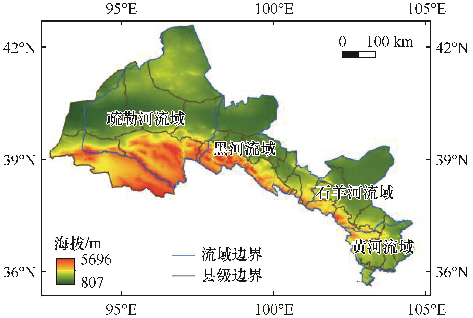
| 4 |
Yilmaz F C, Zengin M, Tekin Cure C.Determination of ecologically sensitive areas in Denizli province using geographic information systems (GIS) and analytical hierarchy process (AHP)[J].Environmental Monitoring and Assessment,2020,192(9):1-13.
|
| 5 |
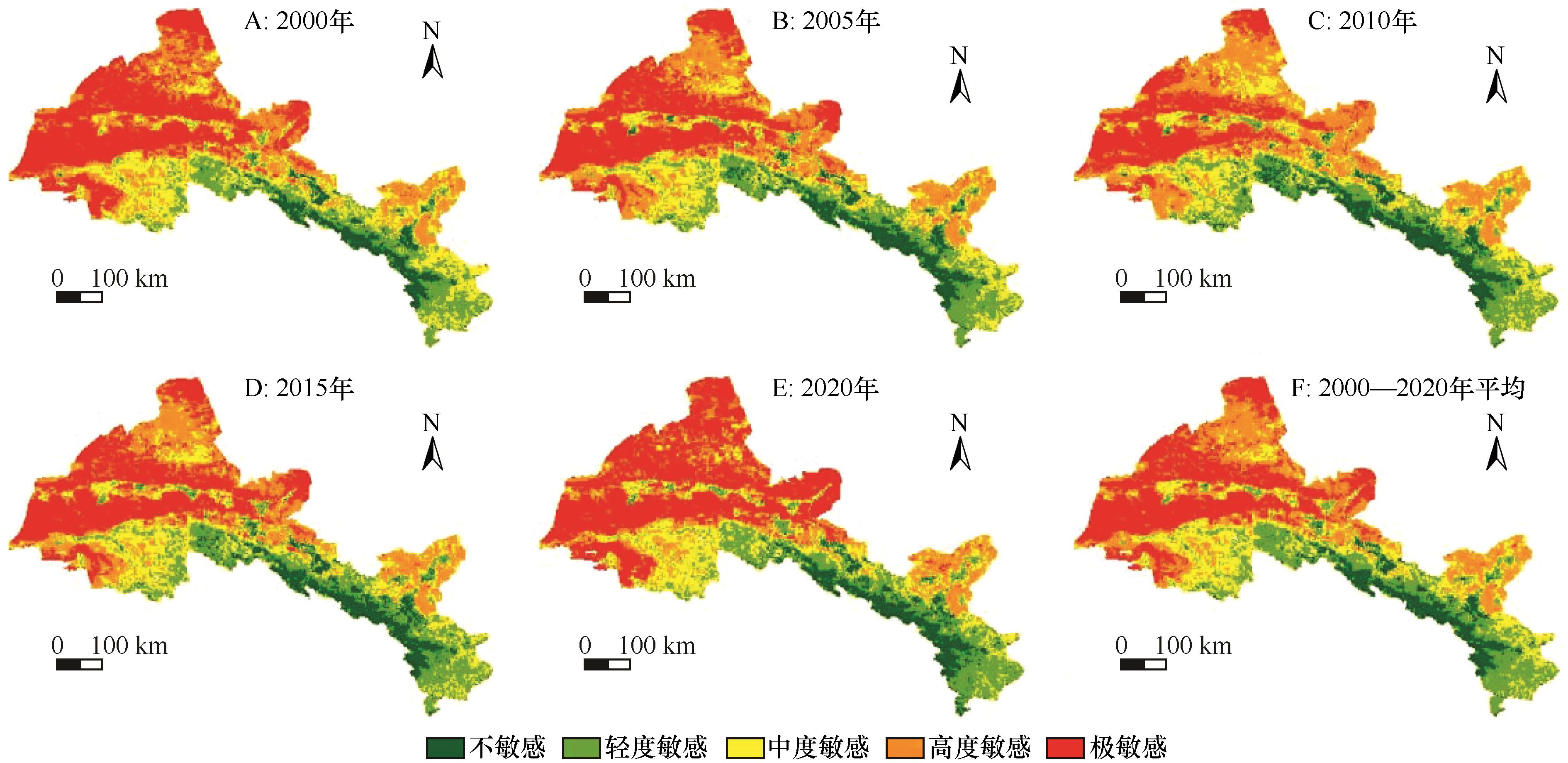
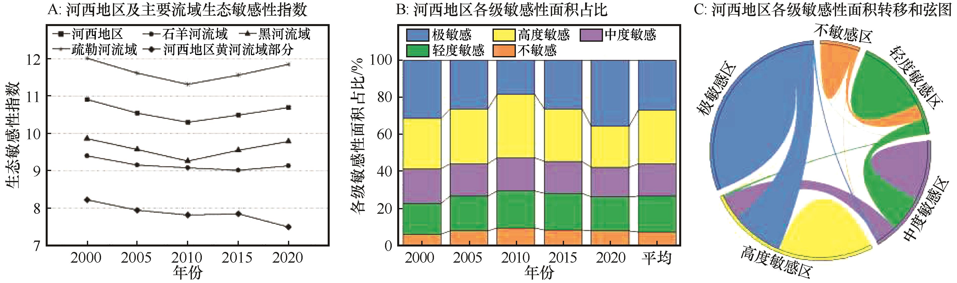
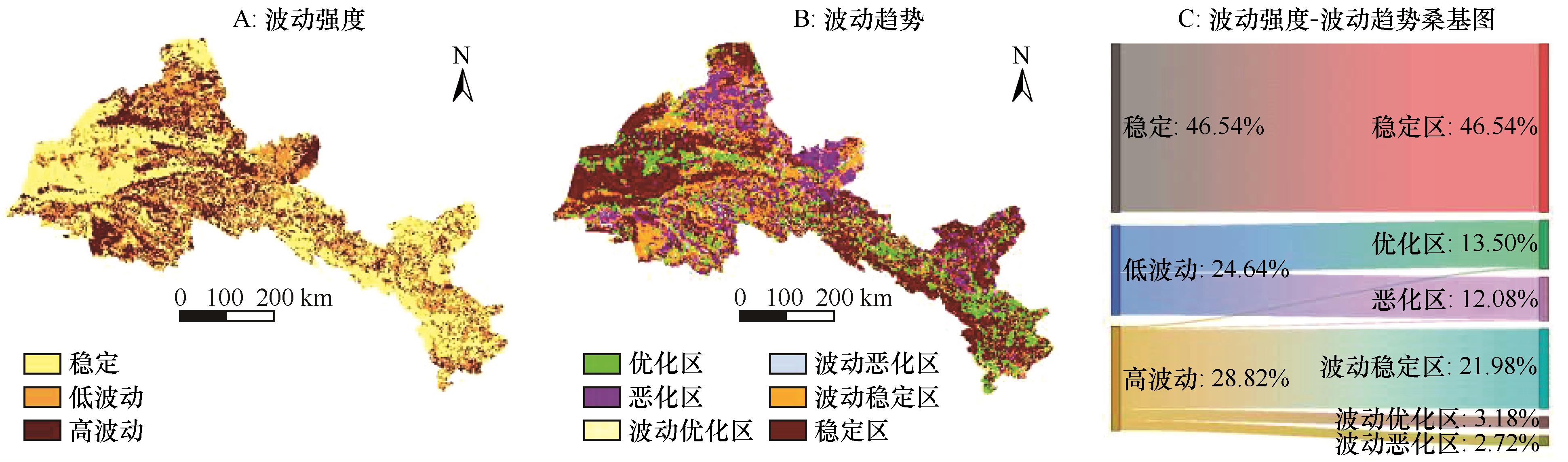
姜旭海,韩玲,白宗璠,等.内蒙古自治区沙漠化敏感性时空演变格局和趋势分析[J].生态学报,2023,43(1):364-378.
|
| 6 |
易丹,赵小敏,郭熙,等.基于生态敏感性评价和CA-Markov模拟的平原型城市开发边界划定:以南昌市为例[J].应用生态学报,2020,31(1):208-218.
|
| 7 |
Shi Y, Li J, Xie M.Evaluation of the ecological sensitivity and security of tidal flats in Shanghai[J].Ecological Indicators,2018,85:729-741.
|
| 8 |
蔡文博,蔡永立.基于GIS方法的泸沽湖流域水土流失敏感性评价[J].水土保持研究,2014,21(3):79-83.
|
| 9 |
潘竟虎,董晓峰.基于GIS的黑河流域生态环境敏感性评价与分区[J].自然资源学报,2006(2):267-273.
|
| 10 |
赵志荣,许端阳,张绪教,等.2000-2015年内蒙古地区土地沙漠化脆弱性评估[J].水土保持研究,2020,27(1):168-175.
|
| 11 |
马彪,衣俊国.黑龙江省土壤盐渍化敏感性分析[J].环境科学与管理,2011,36(5):133-135.
|
| 12 |
陈锐银,严冬春,文安邦,等.基于GIS/CSLE的四川省水土流失重点防治区土壤侵蚀研究[J].水土保持学报,2020,34(1):17-26.
|
| 13 |
李振亚,魏伟,周亮,等.基于空间距离指数的中国西北干旱内陆河流域生态敏感性时空演变特征:以石羊河流域为例[J].生态学报,2019,39(20):7463-7475.
|
| 14 |
赵银兵,陈利顶,孙然好,等.基于资源利用和灾害风险的京津冀地区环境地质敏感性区划[J].生态学报,2022,42(6):2251-2264.
|
| 15 |
张强,冯悦,魏伟,等.基于GIS的祁连山生态敏感性评价[J].安全与环境学报,2019,19(3):1056-1064.
|
| 16 |
刘康,徐卫华,欧阳志云,等.基于GIS的甘肃省土地沙漠化敏感性评价[J].水土保持通报,2002(5):29-31.
|
| 17 |
孙小涛,周忠发,陈全,等.重点生态功能区水土流失敏感性评价与分布研究:以贵州省雷山县为例[J].水土保持学报,2016,30(6):73-78.
|
| 18 |
李振亚,魏伟,周亮,等.中国陆地生态敏感性时空演变特征[J].地理学报,2022,77(1):150-163.
|
| 19 |
郭泽呈,魏伟,石培基,等.中国西北干旱区土地沙漠化敏感性时空格局[J].地理学报,2020,75(9):1948-1965.
|
| 20 |
Yi L, Yu R, Lang L, et al. Spatiotemporal impacts of climate change and human activities on water resources and ecological sensitivity in the Mekong subregion in Cambodia[J].Environmental Science and Pollution Research International,2023,30(2):256-267.
|
| 21 |
Honglei C, Mei L, Chen C.Ecological restoration strategies for the topography of loess plateau based on adaptive ecological sensitivity evaluation:a case study in Lanzhou,China[J].Sustainability,2022,14(5):1125-1136.
|
| 22 |
Alok R, Kant L S.Spatial E-PSR modelling for ecological sensitivity assessment for arid rangeland resilience and management[J].Ecological Modelling,2023,478:1446-1453.
|
| 23 |
Yuan X, Rui L, Chang X,et al.Ecological sensitivity evaluation and explanatory power analysis of the Giant Panda National Park in China[J].Ecological Indicators,2023,146:1-9.
|
| 24 |
李新国,古丽克孜·吐拉克,赖宁.基于RS/GIS的博斯腾湖湖滨绿洲土壤盐渍化敏感性研究[J].水土保持研究,2016,23(1):165-168.
|
| 25 |
王娇,程维明,祁生林,等.基于USLE和GIS的水土流失敏感性空间分析:以河北太行山区为例[J].地理研究,2014,33(4):614-624.
|
| 26 |
戴尔阜,方创琳.甘肃河西地区生态问题与生态环境建设[J].干旱区资源与环境,2002(2):1-5.
|
| 27 |
吕彪.河西走廊水资源特征及其生态环境问题[J].国土与自然资源研究,2003(1):12-14.
|
| 28 |
刘康,欧阳志云,王效科,等.甘肃省生态环境敏感性评价及其空间分布[J].生态学报,2003,23(12):2711-2718.
|
| 29 |
游漫,贺中华,张浪,等.基于相对湿润指数的贵州省气象干旱时空变化特征研究[J].水土保持研究,2022,29(4):255-262.
|
| 30 |
王飞,丁建丽,伍漫春.基于NDVI-SI特征空间的土壤盐渍化遥感模型[J].农业工程学报,2010,26(8):168-173.
|
| 31 |
陈实,徐斌,金云翔,等.北疆农区土壤盐渍化遥感监测及其时空特征分析[J].地理科学,2015,35(12):1607-1615.
|
| 32 |
高星,吴克宁,周娜.景泰县耕地后备资源生态敏感性评价与空间利用对策研究[J].中国农业资源与区划,2020,41(4):43-51.
|
| 33 |
Bui E N, Henderson B L.Vegetation indicators of salinity in northern Queensland[J].Austral Ecology,2003,28(8):539-552.
|
| 34 |
石三娥,魏伟,杨东,等.基于RSEDI的石羊河流域绿洲区生态环境质量时空演变[J].生态学杂志,2018,37(4):1152-1163.
|
| 35 |
赵正嫄,张云龙,李婷,等.基于空间距离指数的青藏高原生态敏感性综合评价及时空演变分析[J].生态学报,2022,42(18):7403-7416.
|
| 36 |
苏溥雅,齐实,梁斌,等.西北五省生态敏感性分析[J].甘肃农业大学学报,2019,54(2):171-179.
|
| 37 |
王劲峰,徐成东.地理探测器:原理与展望[J].地理学报,2017,72(1):116-134.
|
| 38 |
张若琰,刘卫东,宋周莺.基于地理探测器的中国国家级开发区时空演化过程及其驱动力研究[J].自然资源学报,2021,36(10):2672-2683.
|
| 39 |
许丽,高光耀,王晓峰,等.气候变化和人类活动对中国北方旱区植被变绿的定量贡献[J].生态学报,2023,43(9):1-10.
|
| 40 |
张新胜,蔡明勇,邰文飞,等.陕西秦岭地区生态干扰风险空间分异规律研究[J].水土保持研究,2023,30(4):115-121.
|
 ), 宋玉琳2(
 甘公网安备 62010202000688号