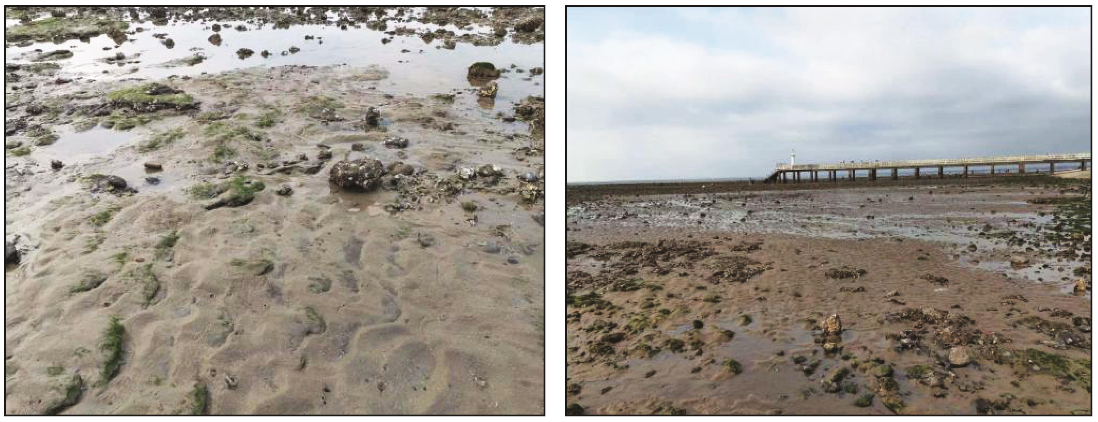
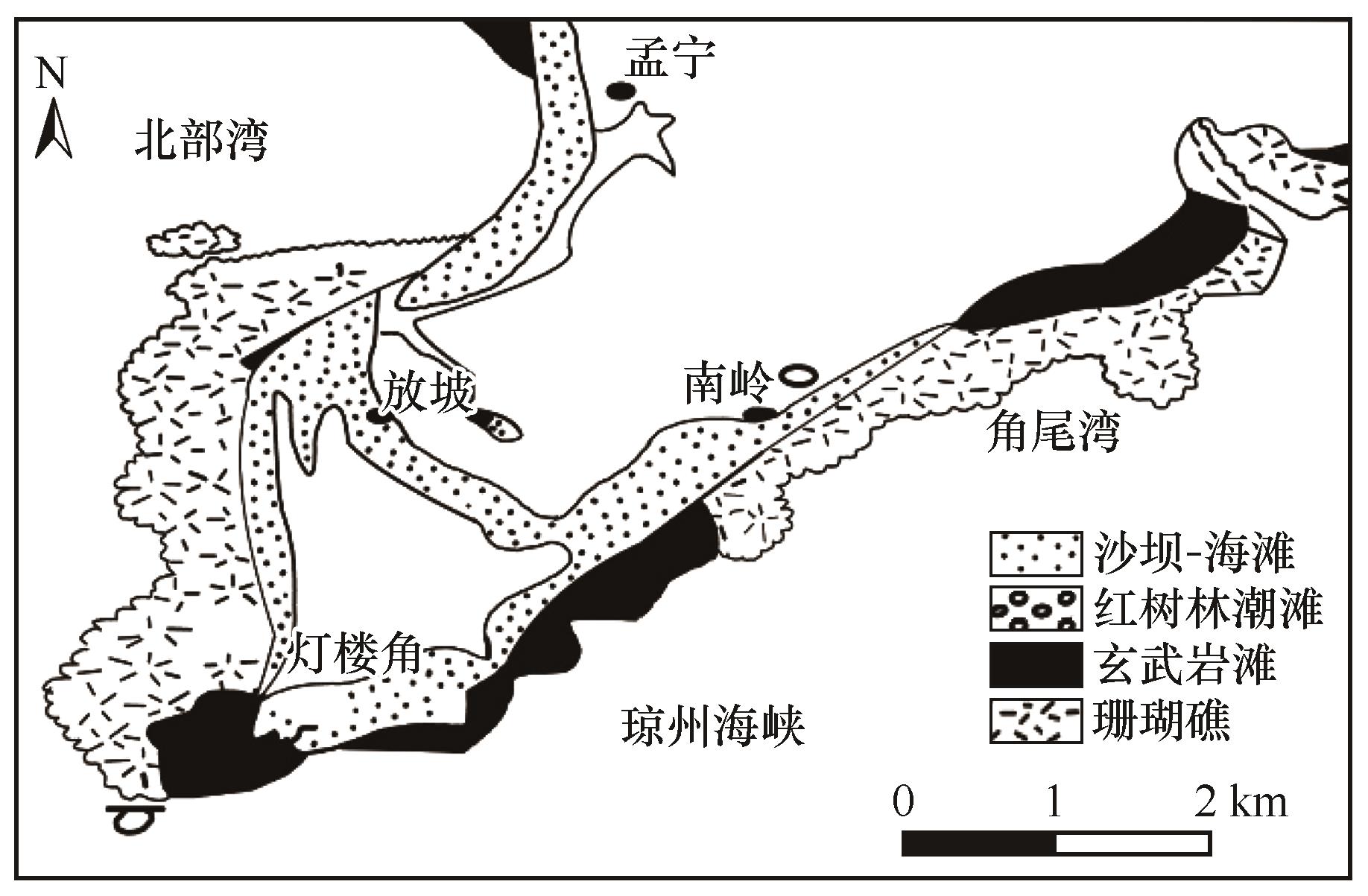
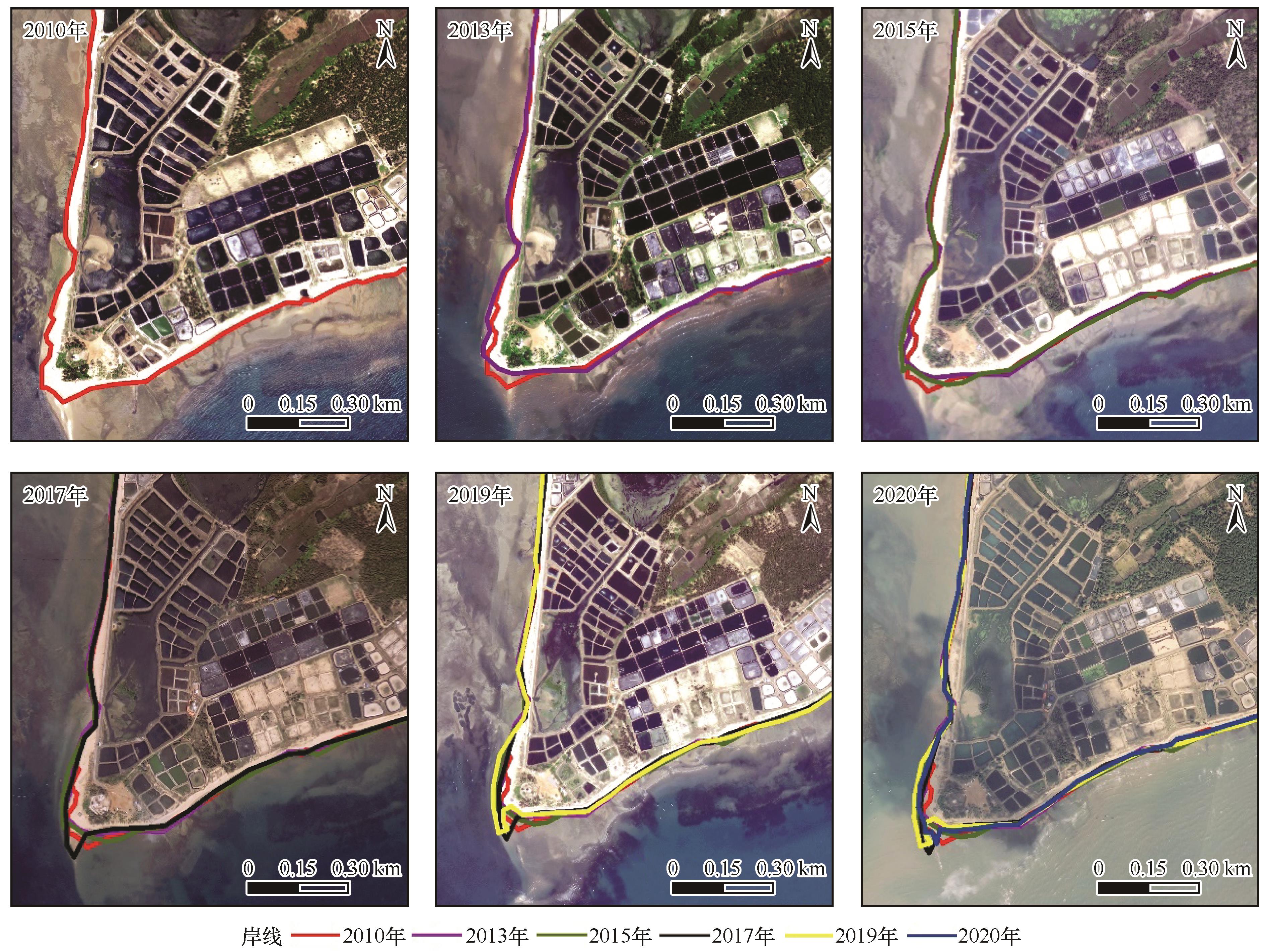
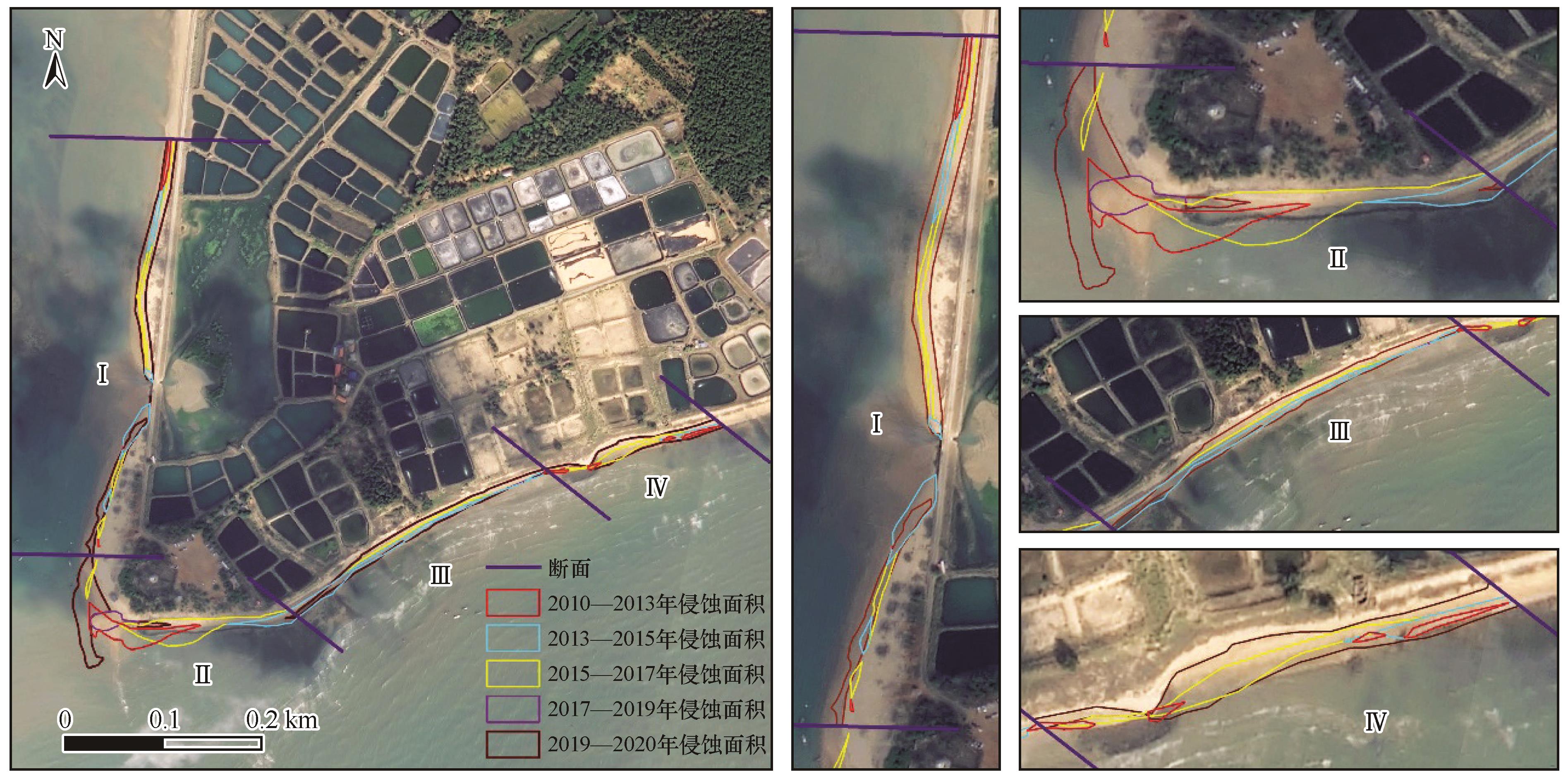
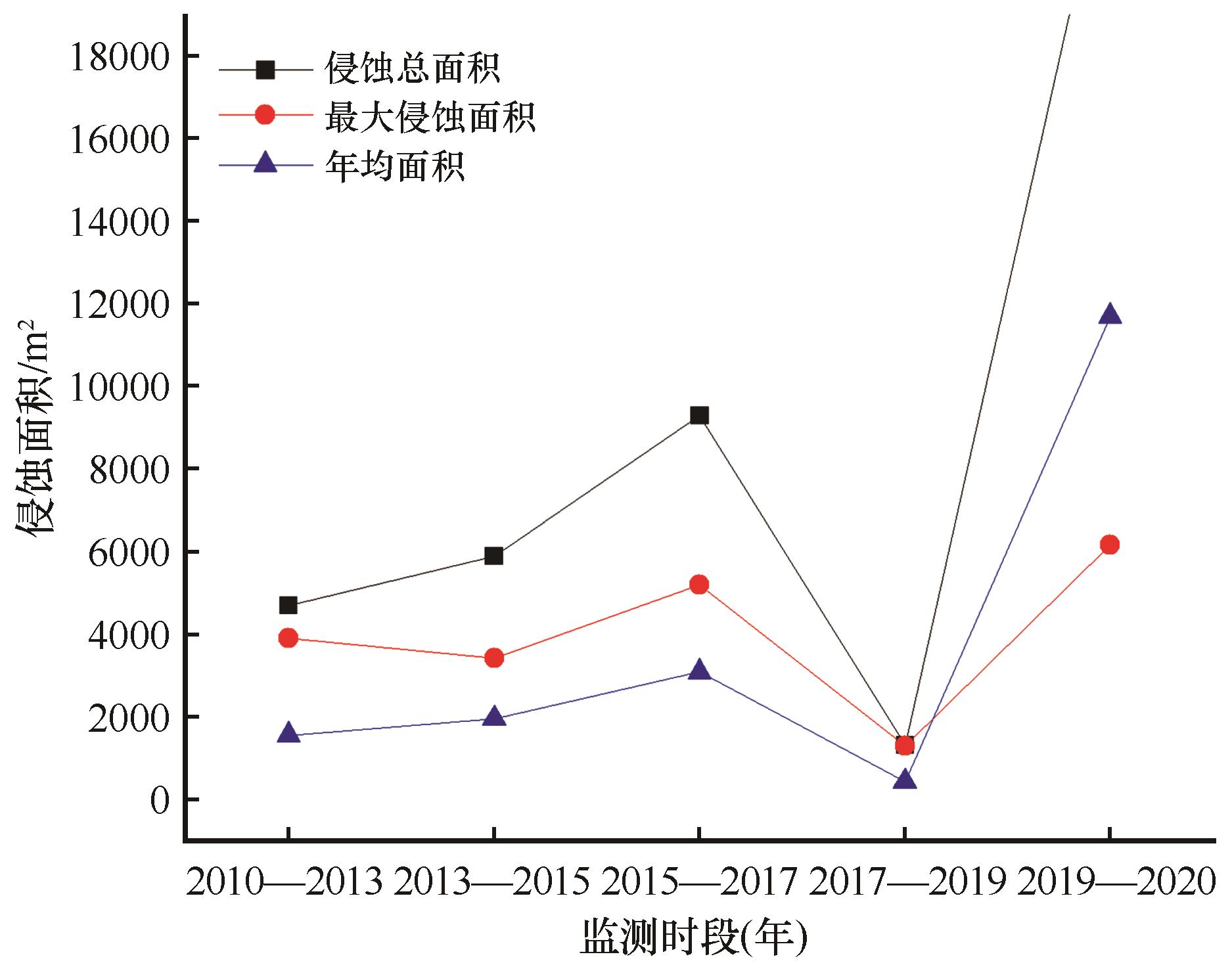
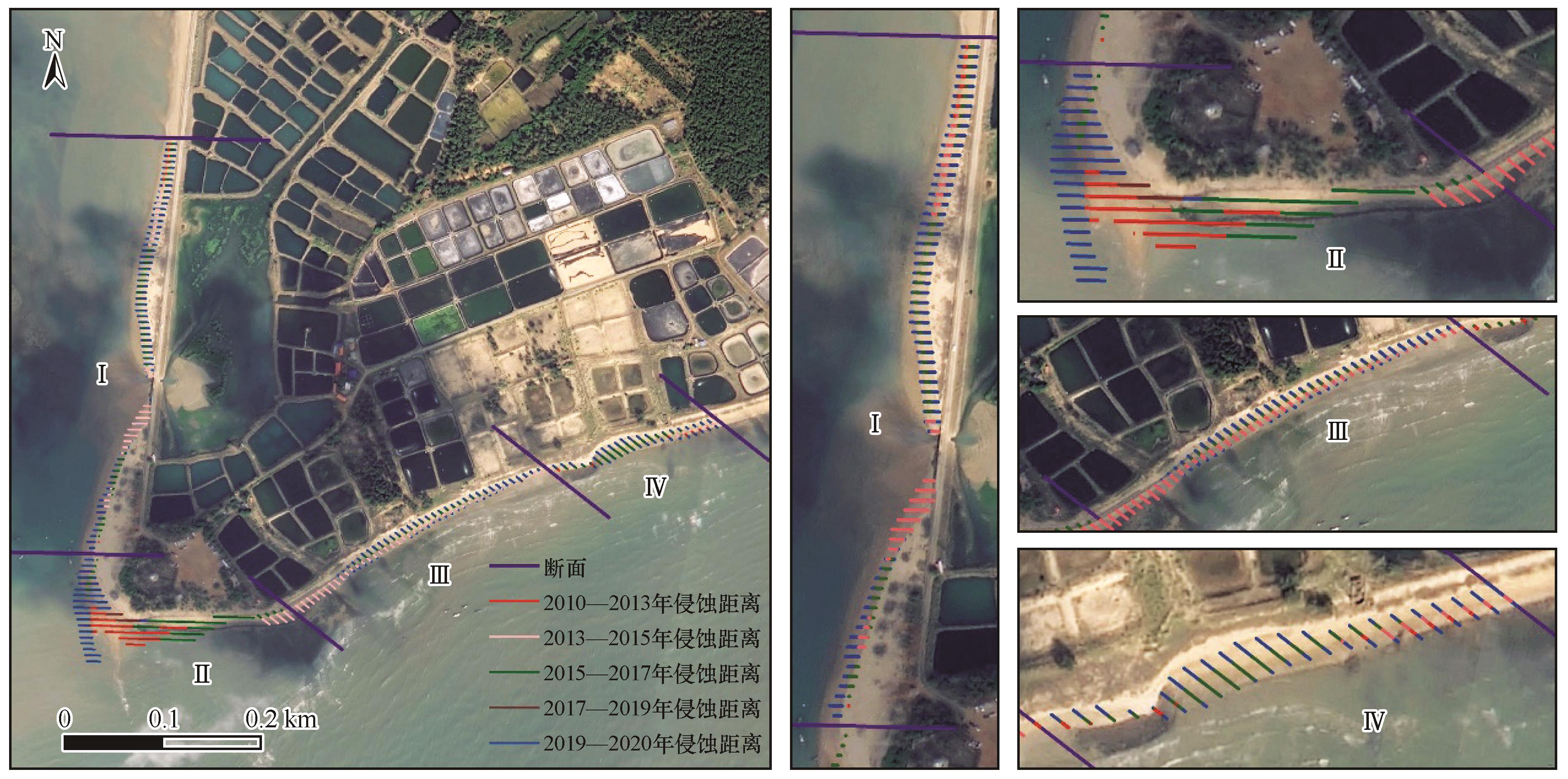
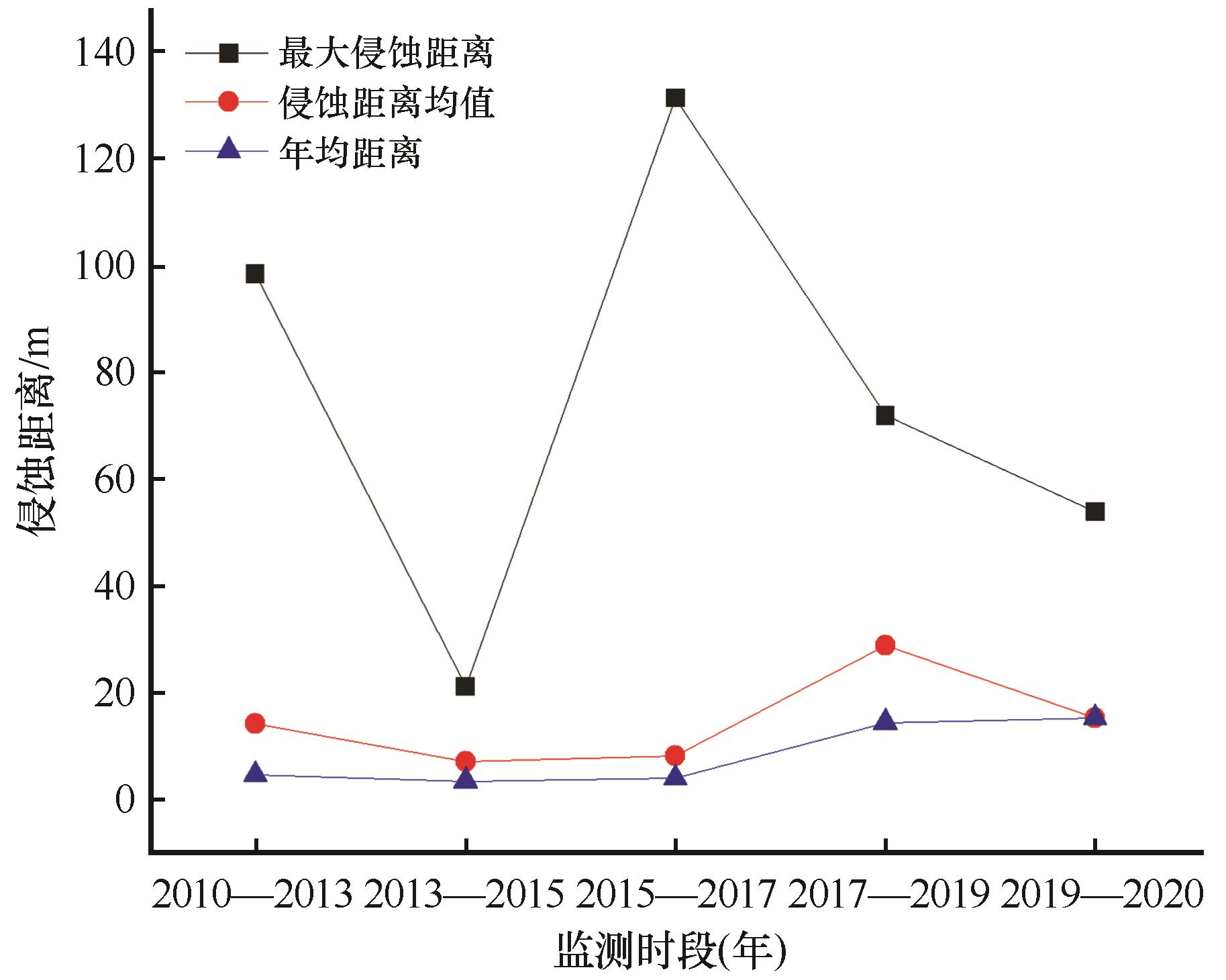
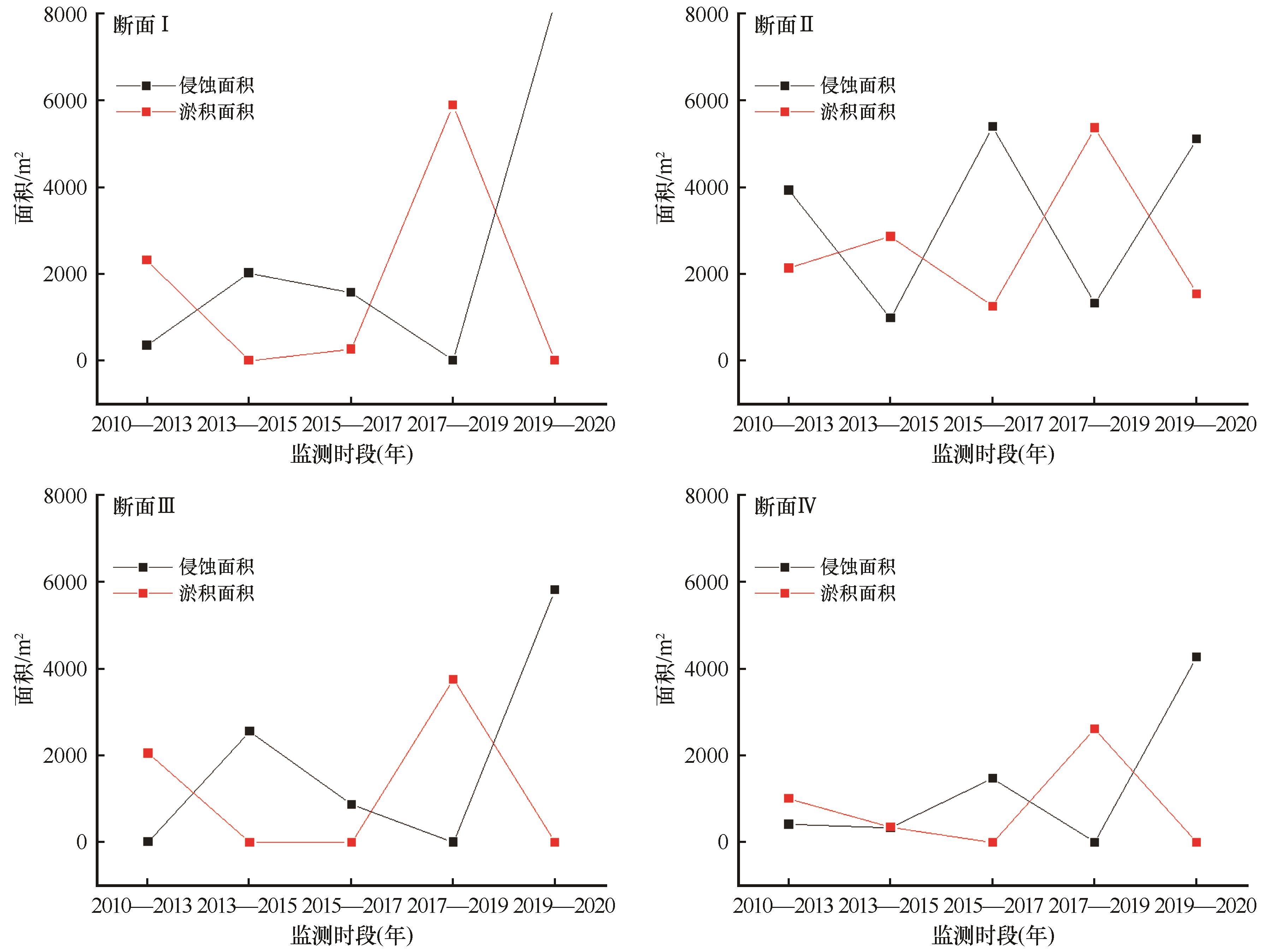
| 1 |
杨子庚.海洋地质学[M].济南:山东教育出版社,2004:55-63.
|
| 2 |
于德海,彭建兵,李滨.海岸带侵蚀灾害研究进展及思考[J].工程地质学报,2010,18(6):867-872.
|
| 3 |
赵焕庭,王丽荣,宋朝景.南海珊瑚礁地貌模型研究[J].海洋学报,2014,36(9):112-120.
|
| 4 |
叶海民,周辉,钟小帅.中国南海某珊瑚砂岛动力环境分析[J].土工基础,2013,27(5):50-52.
|
| 5 |
王庆,朱君,战超.海岸侵蚀与防护技术研究进展[J].海岸工程,2022,41(4):301-312.
|
| 6 |
邵超.海滩-珊瑚礁海岸侵蚀及适应性管理研究[D].厦门:国家海洋局第三海洋研究所,2016.
|
| 7 |
陈吉余.中国海岸带地貌[M].北京:海洋出版社,1995.
|
| 8 |
Titlyanov E A, Titlyanova T V, Li X,et al.Coral reef marine plants of Hainan Island[J].New York,USA:Academic Press,2017:1-4.
|
| 9 |
Burke L M, Selig E, Spalding M D,et al.Reefs at risk in Southeast Asia[J].World Resources Institute,2002,83(12):2008.
|
| 10 |
Ruz M H, Catherine M F.Influence of high water levels on aeolian sand transport:upper beach/dune evolution on a macrotidal coast,Wissant Bay,northern France[J].Geomorphology,2004,60(1/2):73-87.
|
| 11 |
Thomalla F, Vincent C E.Beach response to shore-parallel breakwaters at Sea Palling,Norfolk,UK[J].Estuarine,Coastal and Shelf Science,2003,56:203-212.
|
| 12 |
Banna M M E, Hereher M E.Detecting temporal shoreline changes and erosion / accretion rates,using remote sensing,and their associated sediment characteristics along the coast of North Sinai,Egypt[J].Environmental Geology,2008,58(7):1419-1427.
|
| 13 |
Komar P D.Beach Process and Sedimentation[M].New Jersey,USA:Prentice-Hall,1998.
|
| 14 |
Dean R G.Equilibrium beach profiles:characteristics and applications[J].Journal of Coastal Research,1991,7(1):53-84.
|
| 15 |
王艳红,曾成杰,陆培东,等.三亚湾东段海岸侵蚀与海滩养护[J].自然资源学报,2022,37(4):1049-1060.
|
| 16 |
李团结,刘春杉,李涛,等.雷州半岛海岸侵蚀及其原因研究[J].热带地理,2011,31(3):243-250.
|
| 17 |
陈柳云,吴苑,张玉强.MEBM 视角下的广东徐闻珊瑚礁保护研究进展[J].生态科学,2022,41(4):231-241.
|
| 18 |
王丽荣,赵焕庭,宋朝景,等.雷州半岛灯楼角海岸地貌演变[J].海洋学报,2002,24(6):135-144.
|
| 19 |
雷隆鸿,王丽荣,赵焕庭.雷州半岛西南部灯楼角热带海岸的景观生态结构研究[J].海洋通报,2006,25(4):42-48.
|
| 20 |
赵焕庭,宋朝景,王丽荣,等.雷州半岛灯楼角珊瑚礁初步观察[J].海洋通报,2001,20(2):87-91.
|
| 21 |
王丽荣,赵焕庭,宋朝景.人类活动对徐闻灯楼角珊瑚礁生态系统的影响[J].海洋开发与管理,2006,23(1):81-85.
|
| 22 |
符国伟,宋艳伟,袁坤,等.博鳌珊瑚岛围填导致邻近海岸侵蚀、淤积演变的研究[J].海洋环境科学,2022,41(2):174-179.
|
| 23 |
Mangor K.Shoreline Management Guidelines[M].Netherlands:DHI Water and Environment,2004:294.
|
| 24 |
赵焕庭,王丽荣,宋朝景,等.雷州半岛灯楼角珊瑚岸礁的特征[J].海洋地质与第四纪地质,2002,22(2):35-40.
|
| 25 |
李锋,沈城,张艳苹,等.广东徐闻珊瑚礁国家级自然保护区珊瑚种类及覆盖率分析[J].江苏农业科学,2019,47(24):304-308.
|
| 26 |
张争胜,孙武,周永章.热带滨海干旱地区生态环境脆弱性定量评价:以雷州半岛为例[J].中国沙漠,2008,28(1)125-130.
|
| 27 |
张艳苹,沈城,李锋,等.广东徐闻珊瑚礁国家级自然保护区海域水质环境状况分析及评价[J].热带农业科学,2019,39(3):39-43.
|
| 28 |
国家海洋局.2022年中国海平面公报[EB/OL].2023-04-14..
|
| 29 |
季子修.中国海岸侵蚀特点及侵蚀加剧原因分析[J].自然灾害学报,1996,5(2):65-75.
|
| 30 |
屈建军,王涛,肖洪浪,等.防浪固沙障:200420041517.7[P].2005-01-26.
|
| 31 |
屈建军,洪贤良,李芳,等.聚乳酸(PLA)网格沙障耐老化性能及防沙效果[J].中国沙漠,2021,41(2):51-58.
|
| 32 |
屈建军,李绍武,蒋冲,等.珊瑚沙质岸线防浪固沙障水槽模拟试验研究[J].水土保持通报,2023,43(6):18-24.
|
 ), 屈建军1,2(
 甘公网安备 62010202000688号