
- CN 62-1070/P
- ISSN 1000-694X
- Bimonthly 1981
Journal of Desert Research ›› 2021, Vol. 41 ›› Issue (3): 110-117.DOI: 10.7522/j.issn.1000-694X.2020.00123
Yongdao Gao1,2( ), Rongrong Qiao2, Shuxin Ji2, Xuelian Bai2, Lixiang Wang2, Xueli Chang2()
Received:2020-05-20
Revised:2020-11-23
Online:2021-05-26
Published:2021-05-26
Contact:
Xueli Chang
CLC Number:
Yongdao Gao, Rongrong Qiao, Shuxin Ji, Xuelian Bai, Lixiang Wang, Xueli Chang. Changes and driving factors of crops planting structure in Hetao Irrigation Region in Inner Mongolia[J]. Journal of Desert Research, 2021, 41(3): 110-117.
Add to citation manager EndNote|Ris|BibTeX
URL: http://www.desert.ac.cn/EN/10.7522/j.issn.1000-694X.2020.00123
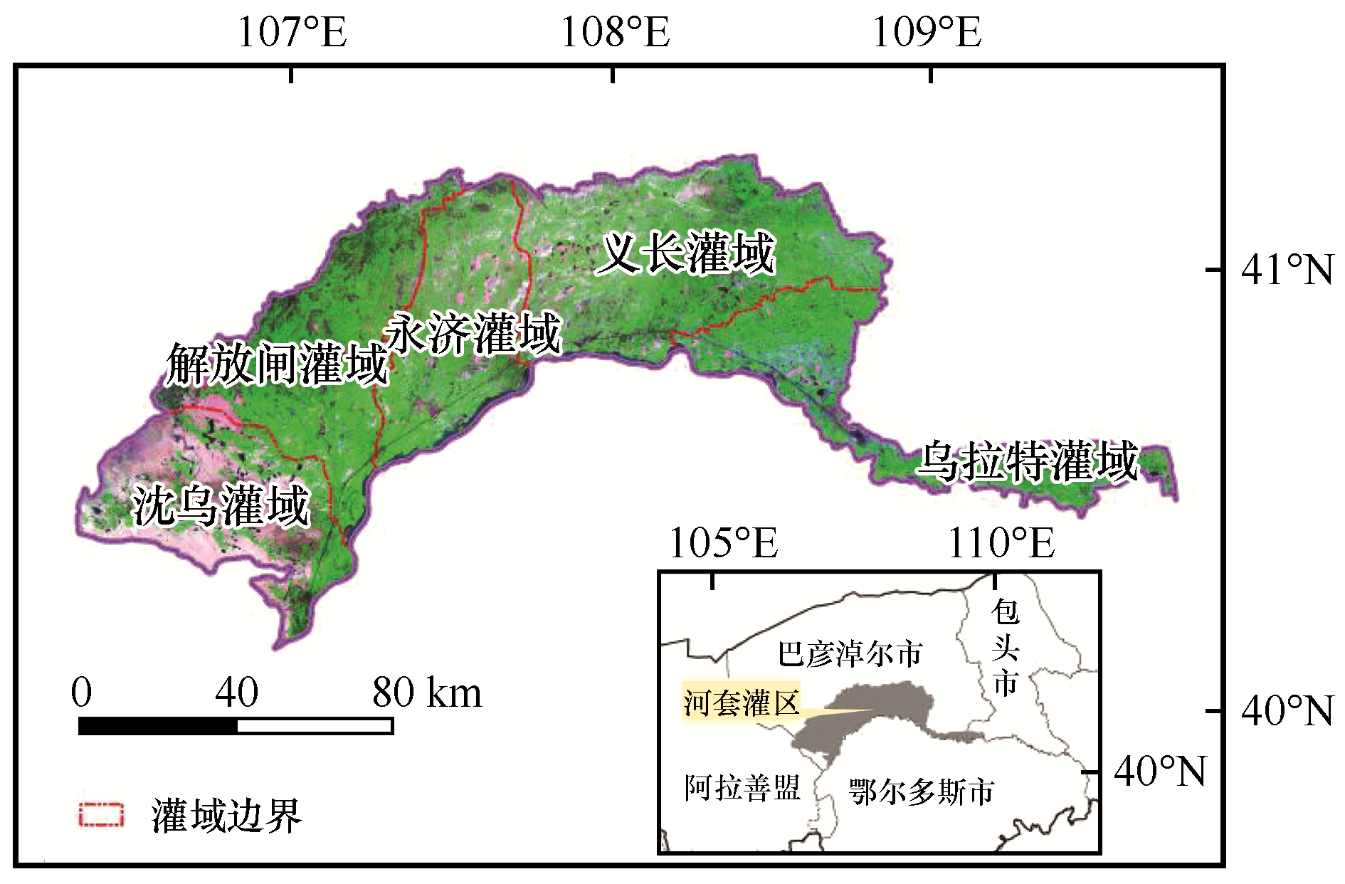
Fig.1 The location of the study area
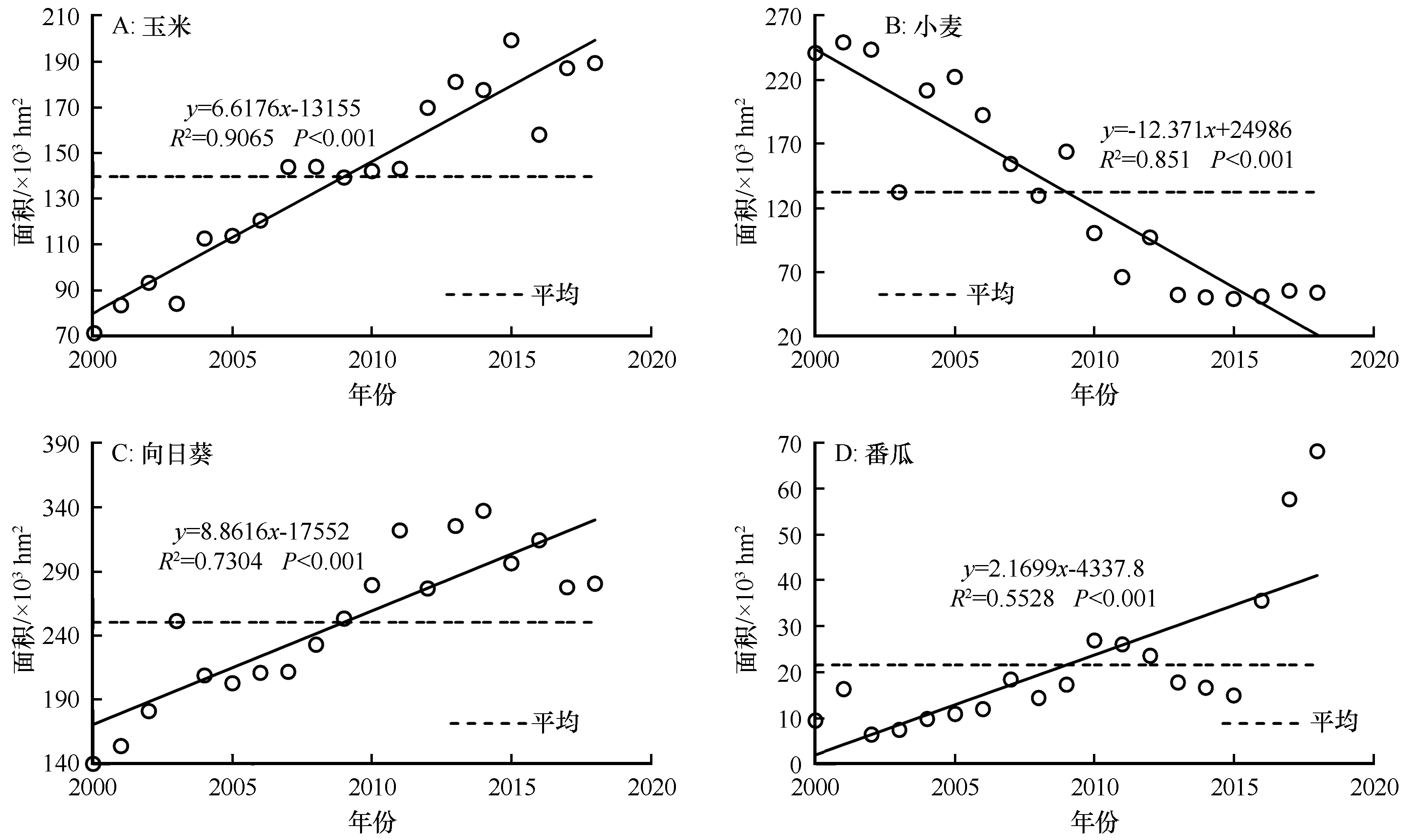
Fig.2 The change trend of planting area of major crops in Hetao region from 2000 to 2018
| 作物 类型 | 平均面积 /103 hm2 | 平均面积 占比/% | 变异 系数 | 标准偏差 /103 hm2 |
|---|---|---|---|---|
| 玉米 | 139.7 | 16.9 | 0.28 | 39.1 |
| 小麦 | 132.5 | 16.5 | 0.57 | 75.5 |
| 向日葵 | 250.5 | 30.4 | 0.23 | 58.3 |
| 番瓜 | 21.6 | 2.6 | 0.76 | 16.4 |
Table 1 Statistical characteristics of planting area of four crops
| 作物 类型 | 平均面积 /103 hm2 | 平均面积 占比/% | 变异 系数 | 标准偏差 /103 hm2 |
|---|---|---|---|---|
| 玉米 | 139.7 | 16.9 | 0.28 | 39.1 |
| 小麦 | 132.5 | 16.5 | 0.57 | 75.5 |
| 向日葵 | 250.5 | 30.4 | 0.23 | 58.3 |
| 番瓜 | 21.6 | 2.6 | 0.76 | 16.4 |
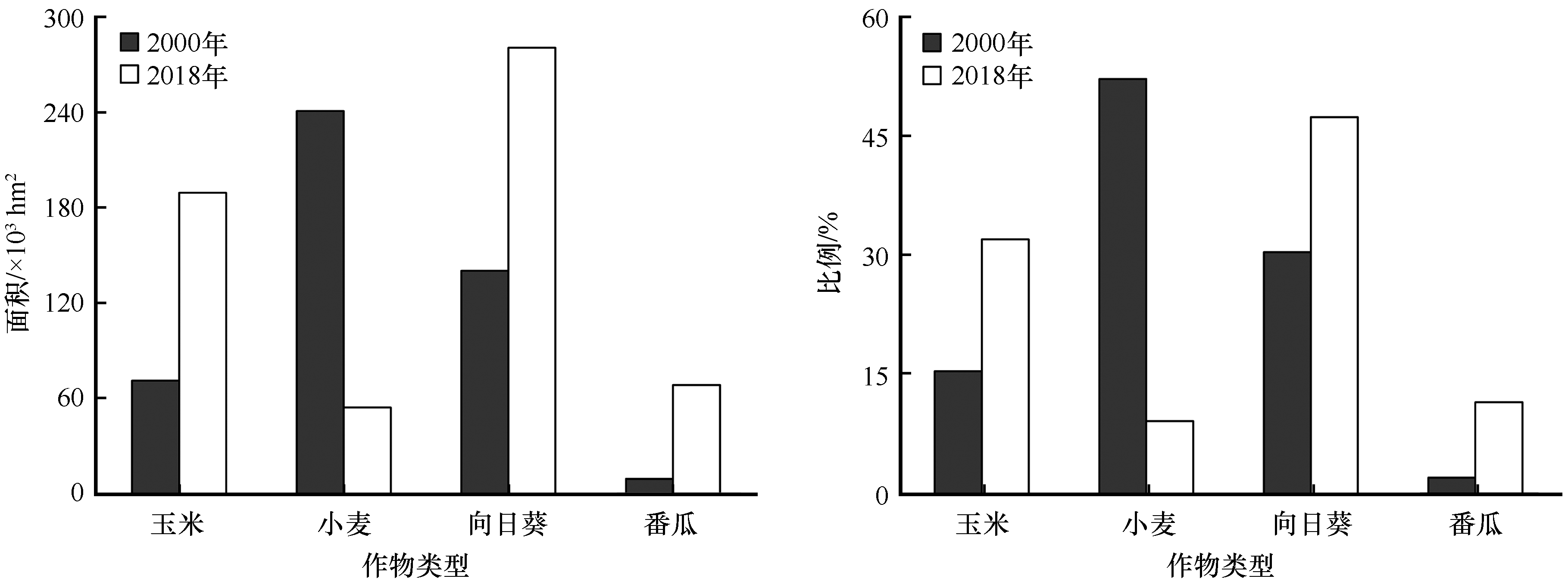
Fig.3 Composition and proportion of crop area in typical years
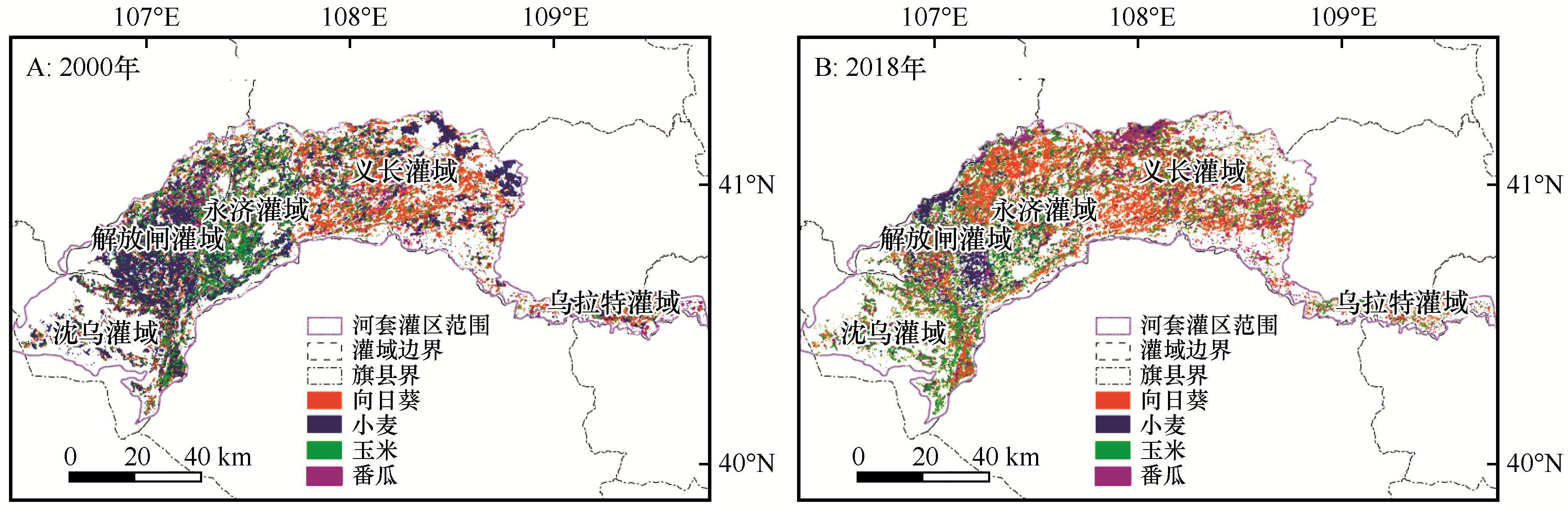
Fig.4 The spatial distribution map of main crops in Hetao Irrigation Region
| 作物 | 玉米 | 小麦 | 向日葵 | 番瓜 | 其他 | 总计 |
|---|---|---|---|---|---|---|
| 玉米 | 20.4 | 63.1 | 29.4 | 2.2 | 34.5 | 149.6 |
| 小麦 | 4.0 | 24.3 | 3.5 | 0.6 | 9.9 | 42.2 |
| 向日葵 | 30.6 | 73.9 | 84.2 | 3.4 | 32.5 | 224.6 |
| 番瓜 | 6.6 | 23.5 | 9.3 | 1.3 | 12.2 | 52.9 |
| 其他 | 6.2 | 44.7 | 9.2 | 1.3 | 108.3 | 169.8 |
| 总计 | 67.8 | 229.6 | 135.5 | 8.8 | 197.4 | 639.0 |
Table 2 Transfer matrix of crop planting area in Hetao Irrigation region from 2000-2018
| 作物 | 玉米 | 小麦 | 向日葵 | 番瓜 | 其他 | 总计 |
|---|---|---|---|---|---|---|
| 玉米 | 20.4 | 63.1 | 29.4 | 2.2 | 34.5 | 149.6 |
| 小麦 | 4.0 | 24.3 | 3.5 | 0.6 | 9.9 | 42.2 |
| 向日葵 | 30.6 | 73.9 | 84.2 | 3.4 | 32.5 | 224.6 |
| 番瓜 | 6.6 | 23.5 | 9.3 | 1.3 | 12.2 | 52.9 |
| 其他 | 6.2 | 44.7 | 9.2 | 1.3 | 108.3 | 169.8 |
| 总计 | 67.8 | 229.6 | 135.5 | 8.8 | 197.4 | 639.0 |
| 影响因素 | 玉米 | 小麦 | 向日葵 | 番瓜 |
|---|---|---|---|---|
| 年引黄水量/亿m3 | -0.021 | 0.193 | -0.149 | 0.007 |
| 地下水埋深/m | 0.448 | -0.490* | 0.524* | 0.616** |
| 年平均气温/℃ | -0.345 | 0.529* | -0.557* | -0.285 |
| 总人口/万人 | -0.767** | 0.788** | -0.820** | -0.479* |
| GDP | 0.936** | -0.925** | 0.854** | 0.713** |
| 城市建成区面积/hm2 | 0.526* | -0.590** | 0.455 | 0.749** |
Table 3 Correlation analysis of planting area and impact factors
| 影响因素 | 玉米 | 小麦 | 向日葵 | 番瓜 |
|---|---|---|---|---|
| 年引黄水量/亿m3 | -0.021 | 0.193 | -0.149 | 0.007 |
| 地下水埋深/m | 0.448 | -0.490* | 0.524* | 0.616** |
| 年平均气温/℃ | -0.345 | 0.529* | -0.557* | -0.285 |
| 总人口/万人 | -0.767** | 0.788** | -0.820** | -0.479* |
| GDP | 0.936** | -0.925** | 0.854** | 0.713** |
| 城市建成区面积/hm2 | 0.526* | -0.590** | 0.455 | 0.749** |
| 预测指标 | 复相关系数 | 显著性 | |
|---|---|---|---|
| 玉米(Ym) | Ym=-0.212X1-35.553X2+6.909X3+1.948X4+0.146X5-0.311X6-240.089 | 0.950 | 0.000 |
| 小麦(Yw) | Yw=1.046X1+56.815X2-0.603X3+3.440X4-0.129 X5-2.555 X6-444.092 | 0.974 | 0.000 |
| 向日葵(Ys) | Ys=0.727X1+2.946X2+4.237X3-10.572X4-0.007X5+2.448X6+1896.227 | 0.945 | 0.000 |
| 番瓜(Yz) | Yz=-0.532X1+37.229X2+0.376X3+0.717X4+0.037X5-0.395X6-159.197 | 0.794 | 0.070 |
Table 4 The influence of key driving factors on fluctuation of crop planting area
| 预测指标 | 复相关系数 | 显著性 | |
|---|---|---|---|
| 玉米(Ym) | Ym=-0.212X1-35.553X2+6.909X3+1.948X4+0.146X5-0.311X6-240.089 | 0.950 | 0.000 |
| 小麦(Yw) | Yw=1.046X1+56.815X2-0.603X3+3.440X4-0.129 X5-2.555 X6-444.092 | 0.974 | 0.000 |
| 向日葵(Ys) | Ys=0.727X1+2.946X2+4.237X3-10.572X4-0.007X5+2.448X6+1896.227 | 0.945 | 0.000 |
| 番瓜(Yz) | Yz=-0.532X1+37.229X2+0.376X3+0.717X4+0.037X5-0.395X6-159.197 | 0.794 | 0.070 |
| 1 | 王新源,刘世增,陈翔舜,等.河西走廊绿洲面积动态及其驱动因素[J].中国沙漠,2019,39(4):212-219. |
| 2 | 吕新,杨磊,张凤华,等.荒漠绿洲区农业特征及其可持续发展策略[J].中国沙漠,2005,25(4):599-603. |
| 3 | 张琪,罗格平,李龙辉,等.基于土地利用/覆被变化表征的现代绿洲演变过程:以天山北坡三工河流域为例[J].地理学报,2016,71(7):1157-1171. |
| 4 | Zhang X F,Zhang L H,He C S,et al.Quantifying the impacts of land use/land cover change on groundwater depletion in Northwestern China:a case study of the Dunhuang oasis[J].Agricultural Water Management,2014,146:270-279. |
| 5 | 张健康,程彦培,张发旺,等.基于多时相遥感影像的作物种植信息提取[J].农业工程学报,2012,28(2):134-141. |
| 6 | 康文平,刘树林,段翰晨.基于MODIS时间序列数据的沙漠化遥感监测及沙漠化土地图谱分析:以内蒙古中西部地区为例[J].中国沙漠,2016,36(2):307-318. |
| 7 | 常茜,鹿化煜,吕娜娜,等.1992—2015年中国沙漠面积变化的遥感监测与气候影响分析[J].中国沙漠,2020,40(1):57-63. |
| 8 | Zhang H,Chen H,Zhou G.The model of wheat yield forecast based on MODIS-NDVI:a case study of Xinxiang[C]//ISPRS Amnals of Photogrammetry,Remote Sensing and Spatial Information Sciences,2012,I-7:25-28. |
| 9 | Wang S X,Wu B,Yang P N.Assessing the changes in land use and ecosystem services in an oasis agricultural region of Yanqi Basin,Northwest China[J].Environmental Monitoring & Assessment,2014,186(12):8343-8357. |
| 10 | 张敏,曹春香,陈伟.基于MODIS NDVI数据的广西植被覆盖时空变化遥感诊断[J].林业科学,2019,55(10):27-37. |
| 11 | 李颖,陈秀万,段红伟,等.多源多时相遥感数据在冬小麦识别中的应用研究[J].地理与地理信息科学,2010,26(4):47-49. |
| 12 | 李晓东,姜琦刚.基于多时相遥感数据的农田分类提取[J].农业工程学报,2015,31(7):145-150. |
| 13 | Tornos L,Huesca M,Dominguez J A,et al.Assessment of MODIS spectral indices for determining rice paddy agricultural practices and hydroperiod[J].ISPRS Journal of Photogrammetry and Remote Sensing,2015,101:110-124. |
| 14 | 袁玉娟,尹云鹤,戴尔阜,等.基于阈值分割的黑龙江省森林类型遥感识别[J].地理科学进展,2016,35(5):655-663. |
| 15 | 竞霞,王锦地,王纪华,等.基于分区和多时相遥感数据的山区植被分类研究[J].遥感技术与应用,2008(4):360,394-397. |
| 16 | 宋茜,周清波,吴文斌,等.农作物遥感识别中的多源数据融合研究进展[J].中国农业科学,2015,48(6):1122-1135. |
| 17 | 王琳,景元书,杨沈斌.基于多时相遥感数据提取水稻种植面积的研究[J].中国农业资源与区划,2013,34(2):21-26. |
| 18 | 汪小钦,邱鹏勋,李娅丽,等.基于时序Landsat遥感数据的新疆开孔河流域农作物类型识别[J].农业工程学报,2019,35(16):180-188. |
| 19 | Sharma A,Liu X W,Yang X J.Land cover classification from multi-temporal,multi-spectral remotely sensed imagery using patch-based recurrent neural networks[J].Neural Networks,2018,105:346-355. |
| 20 | 张谱,管文轲,刘洪霞,等.新疆迪那河流域轮台人工绿洲耕地时空变化特征分析[J].农业机械学报,2019,50(5):291-299. |
| 21 | 张军峰,孟凡浩,包安明,等.新疆孔雀河流域人工绿洲近40年土地利用/覆被变化[J].中国沙漠,2018,38(3):664-672. |
| 22 | 刁维杰,赵勇,翟家齐,等.1987—2017年民勤绿洲面积时空演变规律及驱动因素解析[J].灌溉排水学报,2019,38(10):106-113. |
| 23 | 王让会,孙洪波,赵振勇.新疆且末绿洲土地利用变化机制与驱动力分析[J].干旱区地理,2005(6):849-855. |
| 24 | 任东阳,徐旭,黄冠华.河套灌区典型灌排单元农田耗水机制研究[J].农业工程学报,2019,35(1):98-105. |
| 25 | 陶健宇,杨劲松,姚荣江,等.河套灌区土壤盐分对化肥氮素转化过程的影响研究[J].土壤,2020,52(4):802-810. |
| 26 | 王志超,李仙岳,史海滨,等.覆膜年限及灌水方法对河套灌区农膜残留的影响[J].农业工程学报,2017,33(14):159-165. |
| 27 | 张娜,张栋良,屈忠义,等.不同尺度下内蒙古河套灌区有机质空间变异[J].生态学杂志,2016,35(3):630-640. |
| 28 | 徐岩岩.基于MODIS数据提取东北地区水稻物候时空变化特征[D].北京:中国气象科学研究院,2012. |
| 29 | 温一博,范文义.多时相遥感数据森林类型识别技术研究[J].森林工程,2013,29(2):14-20. |
| 30 | Adler J,Parmryd I.Quantifying colocalization by correlation:the Pearson correlation coefficient is superior to the Mander's overlap coefficient[J].Cytometry.Part A:the Journal of the International Society for Analytical Cytology,2010,77(8):733-742. |
| 31 | 王理想,蔡明玉,白雪莲,等.乌兰布和沙漠东南缘湖泊群消涨与驱动因素[J].中国沙漠,2020,40(2):59-67. |
| 32 | 夏鑫鑫,朱磊,杨爱民,等.基于MODS的生态系统服务正负价值测算:以新疆玛纳斯河流域为例[J].生态学报,2020,40(12):1-14. |
| 33 | 张浚茂,臧传富.东南诸河流域1990—2015年土地利用时空变化特征及驱动机制[J].生态学报,2019,39(24):9339-9350. |
| 34 | 高啸峰,王树德,宫阿都,等.基于主成分分析法的土地利用/覆被变化驱动力研究[J].地理与地理信息科学,2009,25(1):36-39. |
| 35 | 傅家仪,臧传富,吴铭婉.1990—2015年海河流域土地利用时空变化特征及驱动机制研究[J].中国农业资源与区划,2020,41(5):131-139. |
| [1] | Fanmin Mei, Shan Wang, Lixuan Tang, Jin Su. An improved scheme for modeling wind friction threshold velocity dependent on the aspect ratio of individual element and aerodynamic roughness length [J]. Journal of Desert Research, 2020, 40(6): 98-104. |
| [2] | Lingping Li, Taishan Lu, Mingchun Liu, Lili Hu, Suping Wang. Characteristics of hydrological drought based on standardized flow index in Shiyang River Basin of China [J]. Journal of Desert Research, 2020, 40(4): 24-33. |
| [3] | Zhou Xueying, Jia Jian, Liu Guoqiang, Wang Fang, Qiu Huimin, Sun Huaiqin. Characteristics of Precipitation at Hinterland of Taklimakan Desert, China [J]. Journal of Desert Research, 2019, 39(1): 187-194. |
| [4] | Mei Fanmin, Zhang Ningning, Xi Yuan, Liu Xiuxiu. The Aerodynamic Roughness Length over Rough Surfaces Derived from Whole Wind Velocity Profiles with the Log Law and Its Spatial Variations [J]. Journal of Desert Research, 2018, 38(3): 445-454. |
| [5] | Xiao Nan, Dong Zhibao, Nan Weige, Cui Xujia, Li Chao, Xiao Weiqiang, Li Lulu. Characteristics of Surface Wind Field in the Hobq Desert from 1957 to 2014 [J]. Journal of Desert Research, 2018, 38(3): 628-636. |
| [6] | Bai Tao, Ma Rong, Ma Xu, Ha Yanping, Huang Qiang. Threshold of Water and Sediment in Desert wide Valley Reaches upper the Yellow River [J]. Journal of Desert Research, 2018, 38(3): 645-650. |
| [7] | Zhang Dinghai, Li Xinrong, Zhang Peng. Significance of Eco-hydrological Threshold in Artificial Vegetation Ecosystem Management in China Desert Area [J]. JOURNAL OF DESERT RESEARCH, 2017, 37(4): 678-688. |
| [8] | Yao Wenyi, Zhang Xiaohua, Gao Yajun, Jiao Peng. Features of Runoff and Sediment Variations in Wide-valleyed Desert Reach of Upper Yellow River and Contribution Rate of Driving Factors for the Variations [J]. JOURNAL OF DESERT RESEARCH, 2017, 37(2): 361-371. |
| [9] | Zhang Han, Ren Zhiyuan. Remote Sensing Analysis of Vegetation Phenology Characteristics in Shaanxi Province Based on Whittaker Smoother Method [J]. JOURNAL OF DESERT RESEARCH, 2015, 35(4): 901-906. |
| [10] | Chang Yu. Spatial-Temporal Variations of Hourly Strong Precipitation from May to September in Inner Mongolia of China [J]. JOURNAL OF DESERT RESEARCH, 2015, 35(3): 735-743. |
| [11] | Gao Guanlong, Zhang Xiaoyou, Yu Tengfei, Li Xiaoqin. Land Cover Change and Its Driving Factors in the Ejin Oasis during 1987-2008 [J]. JOURNAL OF DESERT RESEARCH, 2015, 35(3): 821-829. |
| [12] | Li Xiaoying, Yao Zhengyi, Wang Hongwei, Xiao Jianhua. The Driving Mechanism of Sandy Desertification in the Zoige Basin of China [J]. JOURNAL OF DESERT RESEARCH, 2015, 35(1): 51-59. |
| [13] | Li Man, Yang Jianping, Tan Chunping, Yang Yuan. Change of Agricultural Planting Structure and Its Causes in the Shuangta Irrigation District in the Shulehe River Basin [J]. JOURNAL OF DESERT RESEARCH, 2014, 34(5): 1417-1423. |
| [14] | Huang Lei, Zhang Zhishan, Hu Yigang, Yang Haotian. Soil CO2 Concentration under Different Types of Plant Communities and the Driving Factors in Arid Desert Area [J]. JOURNAL OF DESERT RESEARCH, 2014, 34(1): 125-132. |
| [15] | WANG Hai-zhen1,2,3, HAN Lu1,2, JIA Wen-suo3. Response of Seeds Germination of Populus euphratica and Populus pruinosa to Slat Stress [J]. JOURNAL OF DESERT RESEARCH, 2013, 33(3): 743-750. |
| Viewed | ||||||
|
Full text |
|
|||||
|
Abstract |
|
|||||
©2018Journal of Desert Research
Tel:0931-8267545
Email:caiedit@lzb.ac.cn;desert@lzb.ac.cn
Support:Magtech