| 1 |
Webb N P, Mcgowan H A, Phinn S R,et al.AUSLEM (AUStralian Land Erodibility Model):a tool for identifying wind erosion hazard in Australia[J].Geomorphology,2006,78(3/4):179-200.
|
| 2 |
Dong Z B, Wang X M, Liu L Y.Wind erosion in arid and semiarid China:an overview[J].Journal of Desert Research,2000,20(2):134-139.
|
| 3 |
Shi P, Ping Y, Yuan Y,et al.Wind erosion research in China:past,present and future[J].Progress in Physical Geography,2004,28(3):366-386.
|
| 4 |
Song Y, Liu L, Yan P,et al.A review of soil erodibility in water and wind erosion research[J].Journal of Geographical Sciences,2005,15(2):167-176.
|
| 5 |
中华人民共和国水利部.2019年中国水土保持公报[J].2020:1-50.
|
| 6 |
Larney F J, Bullock M S, Janzen H H,et al.Wind erosion effects on nutrient redistribution and soil productivity[J].Journal of Soil & Water Conservation,1998,53(2):133-140.
|
| 7 |
Wang T, Xue X, Luo Y,et al.Human causes of aeolian desertification in northern China[J].Sciences in Cold & Arid Regions,2008,1(1):1-13.
|
| 8 |
Lelieveld J, Evans J S, Fnais M,et al.The contribution of outdoor air pollution sources to premature mortality on a global scale[J].Nature,2015,525(7569):367-371.
|
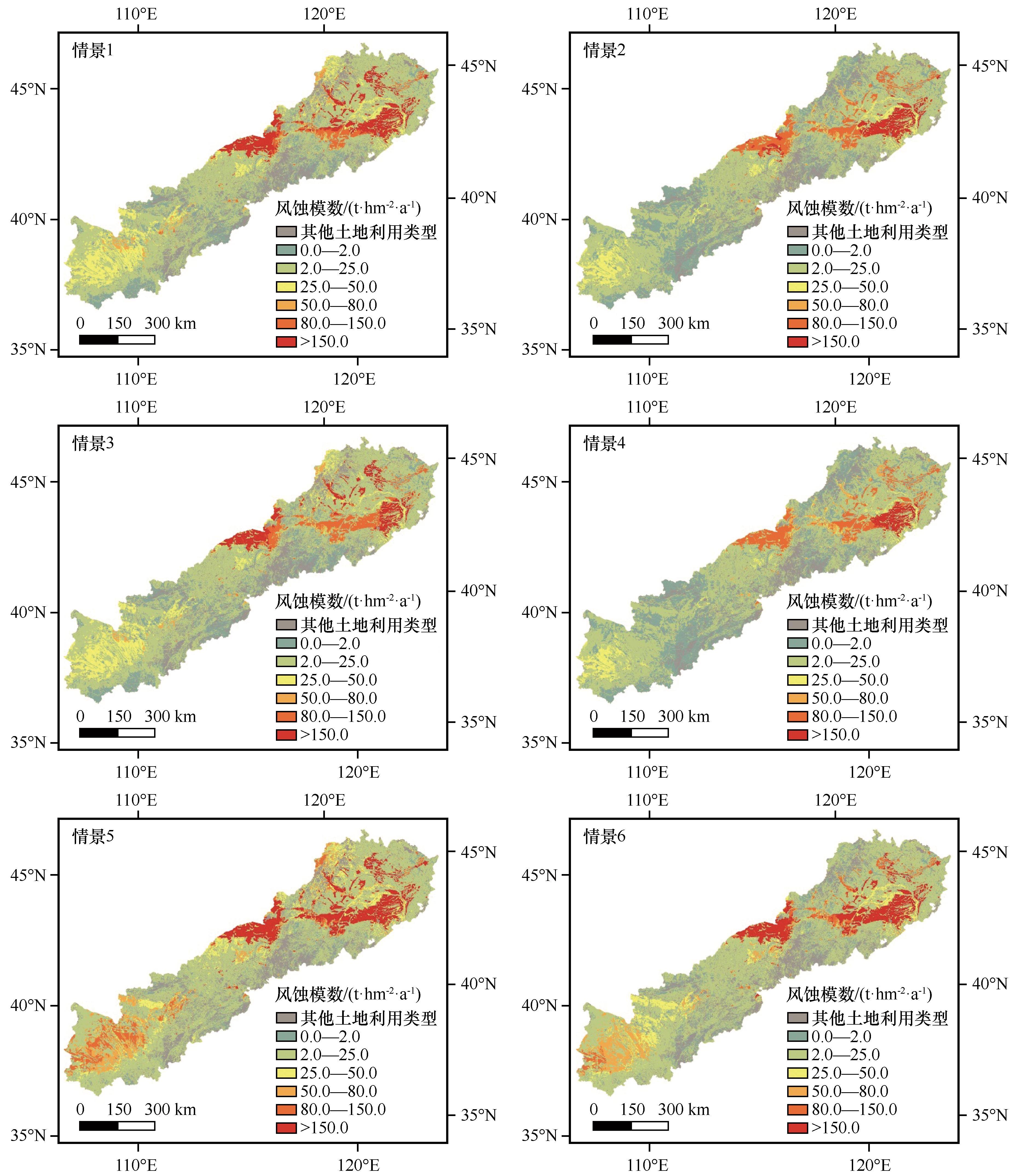
| 9 |
Li X, Song H, Zhai S,et al.Particulate matter pollution in Chinese cities:a real-temporal variations and their relationships with meteorological conditions (2015-2017)[J].Environmental Pollution,2019,246:11-18.
|
| 10 |
刘莹,韩永翔,杨文清,等.沙尘天气、尘卷风对沙漠地区起沙量的贡献[J].中国沙漠,2018,38(6):1175-1179.
|
| 11 |
Borrelli P, David A R, Panos P,et al.Land use and climate change impacts on global soil erosion by water(2015-2070)[J].Proceedings of the National Academy of Sciences,2020,117(36):21994-22001.
|
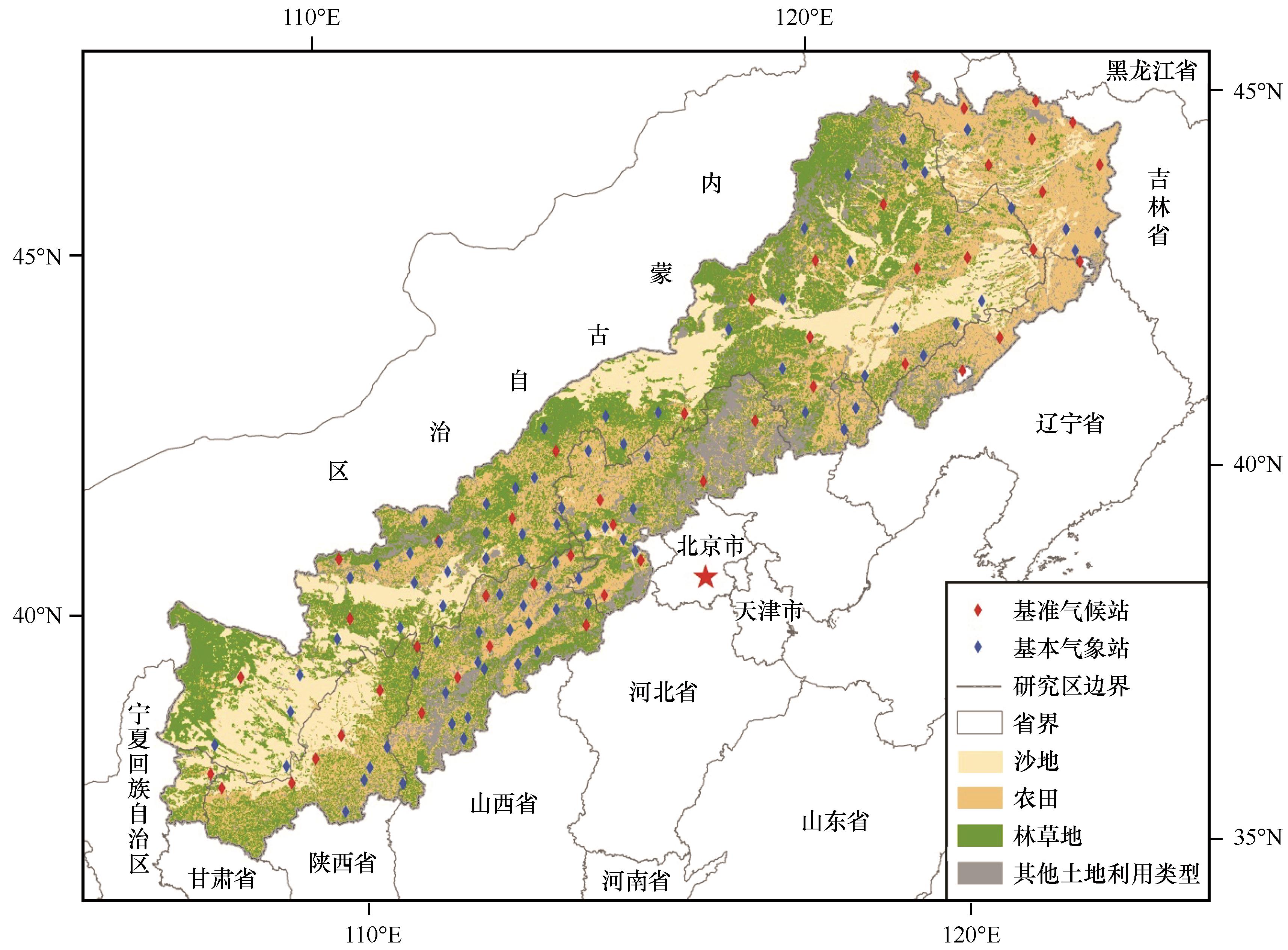
| 12 |
邹学勇,张春来,程宏,等.土壤风蚀模型中的影响因子分类与表达[J].地球科学进展,2014,29(8):875-889.
|
| 13 |
张春来,宋长青,王振亭,等.土壤风蚀过程研究回顾与展望[J].地球科学进展,2018,33(1):27-41.
|
| 14 |
Skidmore E L, Tatarko J.Stochastic wind simulation for erosion modeling[J].Transactions of the ASAE,1990,33(6):1893-1899.
|
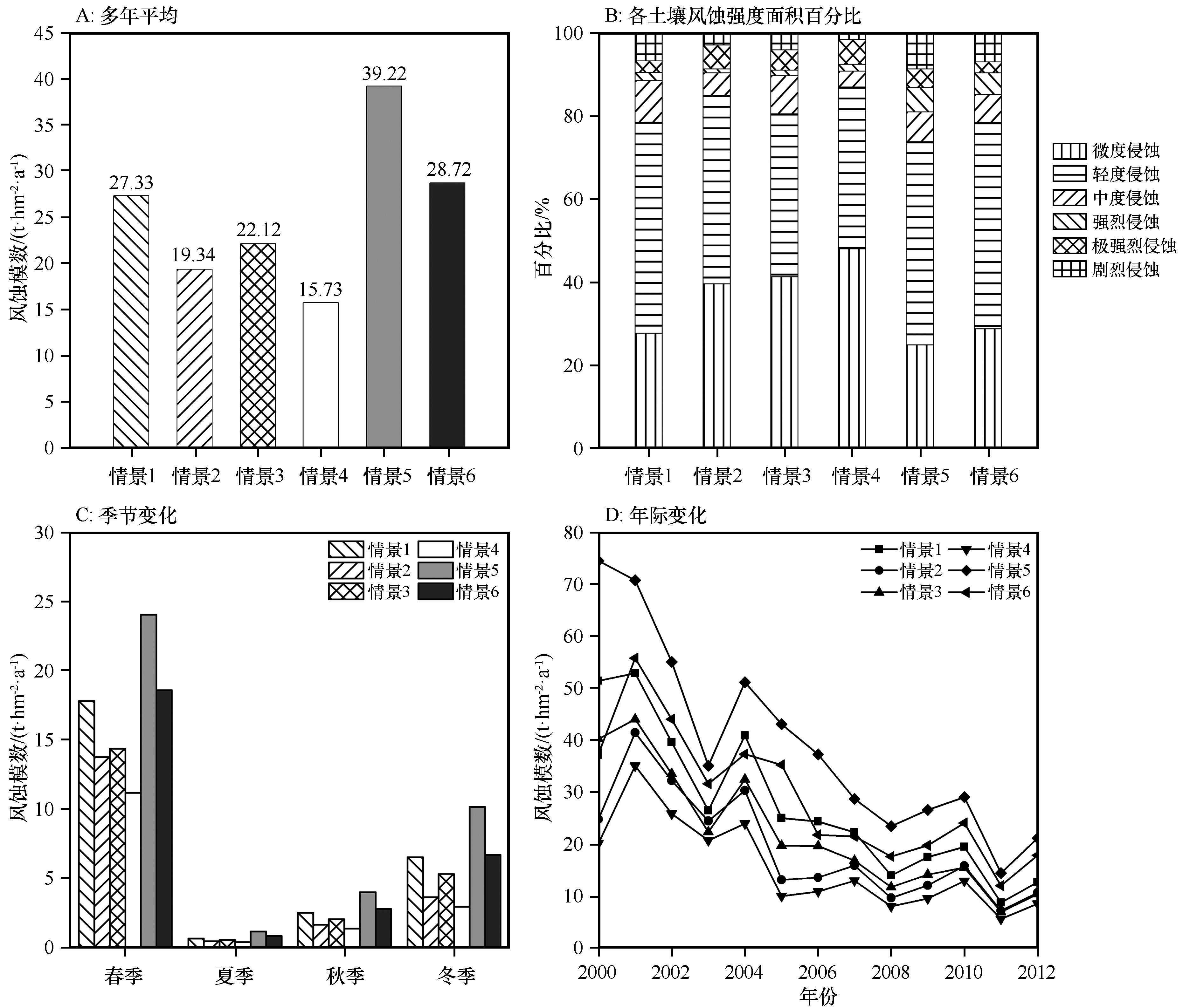
| 15 |
Wagner L E, Tatarko J, Skidmore E L.WIND-GEN:a statistical database and generator for wind data[J].Transaction of ASAE,1992:21-24.
|
| 16 |
Liu B, Qu J, Wagner L E.Building Chinese wind data for Wind Erosion Prediction System using surrogate US data[J].Journal of Soil & Water Conservation,2013,68(4):104-107.
|
| 17 |
Panebianco J E, Buschiazzo D E.Effect of temporal resolution of wind data on wind erosion prediction with the revised wind erosion equation (RWEQ)[J].Ciencia Del Suelo,2013,31(2):189-199.
|
| 18 |
张国平,刘纪远,张增祥,等.中国风蚀景观面积变化与地表风场强度的关系[J].地理学报,2002,57(1):1-10.
|
| 19 |
Lin J K, Guan Q Y, Pan N H,et al.Spatiotemporal variations and driving factors of the potential wind erosion rate in the Hexi Region[J].Land Degradation and Development,2020,32(1):139-157.
|
| 20 |
Du H Q, Wang T, Xue X,et al.Modelling of sand/dust emission in Northern China from 2001 to 2014[J].Geoderma An International Journal of Soil Science,2018,330:162-176.
|
| 21 |
王旭洋,郭中领,常春平,等.中国北方农牧交错带土壤风蚀时空分布[J].中国沙漠,2020,40(1):12-22.
|
| 22 |
Guo Z L, Zobeck T M, Zhang K,et al.Estimating potential wind erosion of agricultural lands in northern China using the Revised Wind Erosion Equation (RWEQ) and GIS[J].Journal of Soil & Water Conservation,2013,68(1):13-21.
|
| 23 |
刘红,王卫,郝彦莉,等.基于风蚀模型的河北省土壤风蚀风险评价[J].水土保持通报,2016,36(2):12-17.
|
| 24 |
巩国丽,刘纪远,邵全琴.基于RWEQ的20世纪90年代以来内蒙古锡林郭勒盟土壤风蚀研究[J].地理科学进展,2014,33(6):825-834.
|
| 25 |
申陆,田美荣,高吉喜.基于RWEQ模型的浑善达克沙漠化防治生态功能区土壤风蚀与主要影响因子分析[J].水土保持研究,2016,23(6):90-97.
|
| 26 |
江凌,肖燚,欧阳志云,等.基于RWEQ模型的青海省土壤风蚀模数估算[J].水土保持研究,2015,22(1):21-25.
|
| 27 |
李智广,邹学勇,程宏.我国风力侵蚀抽样调查方法[J].中国水土保持科学,2013,11(4):17-21.
|
| 28 |
Guo Z L, Chang C P, Wang R D.A Novel Method to Downscale Daily Wind Statistics to Hourly Wind Data for Wind Erosion Modelling[M]. Berlin,Germany:Springer,2016:611-619.
|
| 29 |
Donk S, Liao C, Skidmore E L.Using temporally limited wind data in the wind erosion prediction system[J].Transactions of the ASABE,2008,51(5):1585-1590.
|
| 30 |
Guo Z L, Zobeck T M, Stout J E,et al.The effect of wind averaging time on wind erosivity estimation[J].Earth Surface Processes and Landforms,2012,37(7):797-802.
|
| 31 |
Skidmore E L, Liao C, Donk S J.Simulation of wind speed and direction from limited data[C]//International Soil Conservation Organization Proceedings.Marruecos,2006,May:14-19.
|
| 32 |
van Donk S, Wagner L E, Skidmore E L,et al.Comparison of the weibull model with measured wind speed distributions for stochastic wind generation[J].Transactions of the ASAE,2005,48(2):503-510.
|
| 33 |
中国气象局. 气象观测站分类及命名规则 [S].2019.
|
| 34 |
Fryrear D W, Saleh A, Bilbro J D,et al.Revised Wind Erosion Equation (RWEQ)[R].Wind Erosion and Water Conservation Research Unit,USDA-ARS,Southern Plains Area Cropping Systems Research Laboratory,1998.
|
| 35 |
Zobeck T M, Parker N C, Haskell S,et al.Scaling up from field to region for wind erosion prediction using a field-scale wind erosion model and GIS[J].Agriculture Ecosystems & Environment,2000,82(1/2/3):247-259.
|
| 36 |
Fryrear D W, Bilbro J D, Saleh A,et al.RWEQ:improved wind erosion technology[J].Journal of Soil and Water Conservation,2000,55(2):183-189.
|
| 37 |
Zobeck T M.Soil properties affecting wind erosion[J].Journal of Soil & Water Conservation,1991,46(2):112-118.
|
| 38 |
Pi H W, Huggins D R, Sharratt B.Soil wind erosion influenced by clay amendment in the inland Pacific Northwest,USA[J].Land Degradation and Development,2021,32(1):241-255.
|
| 39 |
Nearing M A, Deer-Ascough L, Laflen J M.Sensitivity analysis of the WEPP hillslope profile erosion model[J].Transactions of the ASAE,1990,33(3):839-849.
|
| 40 |
Feng G, Sharratt B S.Sensitivity analysis of soil and PM10 loss in WEPS using the LHS-OAT method[J].Transactions of the ASABE,2005,48(4):1409-1420.
|
| 41 |
Hagen L J, Wagner L E, Skidmore E L.Analytical solutions and sensitivity analyses for sediment transport in WEPS[J].Transactions of the Asae,1999,42(6):1715-1722.
|
| 42 |
中华人民共和国水利部.土壤侵蚀分级分类标准[M].北京:中国水利水电出版社,2007.
|

 ), Jifeng Li1,2(