
- CN 62-1070/P
- ISSN 1000-694X
- Bimonthly 1981
Journal of Desert Research ›› 2023, Vol. 43 ›› Issue (3): 230-242.DOI: 10.7522/j.issn.1000-694X.2022.00129
Sen Li( ), Changzhen Yan
Received:2022-09-02
Revised:2022-10-24
Online:2023-05-20
Published:2023-05-31
CLC Number:
Sen Li, Changzhen Yan. Mapping oasis structure data based on ChinaCover dataset: a case study of Hexi Inland River Basin[J]. Journal of Desert Research, 2023, 43(3): 230-242.
Add to citation manager EndNote|Ris|BibTeX
URL: http://www.desert.ac.cn/EN/10.7522/j.issn.1000-694X.2022.00129
| 数据集名称 | 发布单位 | 时间 | 分辨率 | 卫星数据源 | 参考文献 |
|---|---|---|---|---|---|
| IGBP DISCover | 国际地圈生物圈计划数据和信息系统 | 1992—1993年 | 1 km | NOAA AVHRR | [ |
| UMD | 马里兰大学 | 1992—1993年 | 1 km | NOAA AVHRR | [ |
| GLC 2000 | 欧洲委员会联合研究中心(JRC) | 2000年 | 1 km | SPOT VGT | [ |
| MOD12Q1 and MCD12Q1 | 美国波士顿大学 | 2001年至今 | 500/1 000 m | Terra and Aqua | [ |
| GlobCover | 欧洲航天局 | 2005—2006/2009年 | 300 m | ENVISAT MERIS | [ |
| CCI-LC | 欧洲航天局 | 2000/2005/2010年 | 300 m | ENVISAT MERIS | [ |
| GLCNMO | 全球制图国际指导委员会 | 2003/2008年 | 500 m | Terra and Aqua | [ |
| FROM-GLC | 清华大学 | 1984—2011年 | 30 m/10 m | Landsat/Sentinel-2 | [ |
| Esri 10-Meter Land Cover | Esri | 2017—2021年 | 10 m | Sentinel-2 | [ |
| Globeland30 | 国家测绘中心 | 2000/2010/2020年 | 30 m | Landsat、环境星、高分一号 | [ |
Table 1 Basic parameters of ten global land cover datasets
| 数据集名称 | 发布单位 | 时间 | 分辨率 | 卫星数据源 | 参考文献 |
|---|---|---|---|---|---|
| IGBP DISCover | 国际地圈生物圈计划数据和信息系统 | 1992—1993年 | 1 km | NOAA AVHRR | [ |
| UMD | 马里兰大学 | 1992—1993年 | 1 km | NOAA AVHRR | [ |
| GLC 2000 | 欧洲委员会联合研究中心(JRC) | 2000年 | 1 km | SPOT VGT | [ |
| MOD12Q1 and MCD12Q1 | 美国波士顿大学 | 2001年至今 | 500/1 000 m | Terra and Aqua | [ |
| GlobCover | 欧洲航天局 | 2005—2006/2009年 | 300 m | ENVISAT MERIS | [ |
| CCI-LC | 欧洲航天局 | 2000/2005/2010年 | 300 m | ENVISAT MERIS | [ |
| GLCNMO | 全球制图国际指导委员会 | 2003/2008年 | 500 m | Terra and Aqua | [ |
| FROM-GLC | 清华大学 | 1984—2011年 | 30 m/10 m | Landsat/Sentinel-2 | [ |
| Esri 10-Meter Land Cover | Esri | 2017—2021年 | 10 m | Sentinel-2 | [ |
| Globeland30 | 国家测绘中心 | 2000/2010/2020年 | 30 m | Landsat、环境星、高分一号 | [ |
| 序号 | Ⅰ级分类 | 代码 | Ⅱ级分类 | 指 标 |
|---|---|---|---|---|
| 1 | 林地 | 101 | 常绿阔叶林 | H=3~30 m,C≥0.2,常绿,阔叶 |
| 102 | 落叶阔叶林 | H=3~30 m,C≥0.2,落叶,阔叶 | ||
| 103 | 常绿针叶林 | H=3~30 m,C≥0.2,常绿,针叶 | ||
| 104 | 落叶针叶林 | H=3~30 m,C≥0.2,落叶,针叶 | ||
| 105 | 针阔混交林 | H=3~30 m,C≥0.2,25%<F<75% | ||
| 106 | 常绿阔叶灌丛 | H=0.3~5 m,C≥0.2,常绿,阔叶 | ||
| 107 | 落叶阔叶灌丛 | H=0.3~5 m,C≥0.2,落叶,阔叶 | ||
| 108 | 常绿针叶灌丛 | H=0.3~5 m,C≥0.2,常绿,针叶 | ||
| 109 | 稀疏林 | H=3~30 m,C=0.04~0.2 | ||
| 110 | 稀疏灌丛 | H=0.3~5 m,C=0.04~0.2 | ||
| 111 | 乔木园地 | 人工植被,H=3~30 m,C≥0.2 | ||
| 112 | 灌木园地 | 人工植被,H=0.3~5 m,C≥0.2 | ||
| 113 | 乔木绿地 | 人工植被,人工表面周围,H=3~30 m,C≥0.2 | ||
| 114 | 灌木绿地 | 人工植被,人工表面周围,H=0.3~5 m,C≥0.2 | ||
| 2 | 草地 | 201 | 温性草原 | K<1,H=0.03~3 m,C≥0.2 |
| 202 | 高寒草原 | K<1,H=0.03~3 m,C≥0.2,T<1 300,海拔>3 200 m | ||
| 203 | 温性草甸 | K≥1,土壤湿润,H=0.03~3 m,C≥0.2 | ||
| 204 | 高寒草甸 | K≥1,土壤湿润,H=0.03~3 m,C≥0.2,T<2 300,海拔>3 200 m | ||
| 205 | 草丛 | K≥1,H=0.03~3 m,C≥0.2 | ||
| 206 | 稀疏草地 | H=0.03~3 m,C =0.04~0.2 | ||
| 207 | 草本绿地 | 人工植被,人工表面周围,H=0.03~3 m,C≥0.2 | ||
| 3 | 耕地 | 301 | 水田 | 人工植被,土地扰动,水生作物,收割过程 |
| 302 | 旱地 | 人工植被,土地扰动,旱生作物,收割过程 | ||
| 4 | 湿地 | 401 | 乔木湿地 | W>2或湿土,H=3~30 m,C≥0.2 |
| 402 | 灌木湿地 | W>2或湿土,H=0.3~5 m,C≥0.2 | ||
| 403 | 草本湿地 | W>2或湿土,H=0.03~3 m,C≥0.2 | ||
| 404 | 湖泊 | 自然水面,静止 | ||
| 405 | 水库/坑塘 | 人工水面,静止 沿海晒盐场地 | ||
| 406 | 河流 | 自然水面,流动 | ||
| 407 | 运河/水渠 | 人工水面,流动 | ||
| 5 | 人工表面 | 501 | 建设用地 | 人工硬表面,包括居住地和工业用地 |
| 502 | 交通用地 | 人工硬表面,线状特征 | ||
| 503 | 采矿场 | 人工挖掘表面 | ||
| 6 | 其他 | 601 | 苔藓/地衣 | 自然,苔藓或地衣覆盖 |
| 602 | 裸岩 | 自然,坚硬表面,石质,C <0.04 | ||
| 603 | 戈壁 | 自然,砾石表面,砾漠,C <0.04 | ||
| 604 | 裸土 | 自然,松散表面,壤质,C <0.04 | ||
| 605 | 沙漠 | 自然,松散表面,沙质,C<0.04 | ||
| 606 | 盐碱地 | 自然,松散表面,高盐分 | ||
| 607 | 冰川/永久积雪 | 自然,水的固态 |
Table 2 Classification system of "carbon budget for the national ecosystem"
| 序号 | Ⅰ级分类 | 代码 | Ⅱ级分类 | 指 标 |
|---|---|---|---|---|
| 1 | 林地 | 101 | 常绿阔叶林 | H=3~30 m,C≥0.2,常绿,阔叶 |
| 102 | 落叶阔叶林 | H=3~30 m,C≥0.2,落叶,阔叶 | ||
| 103 | 常绿针叶林 | H=3~30 m,C≥0.2,常绿,针叶 | ||
| 104 | 落叶针叶林 | H=3~30 m,C≥0.2,落叶,针叶 | ||
| 105 | 针阔混交林 | H=3~30 m,C≥0.2,25%<F<75% | ||
| 106 | 常绿阔叶灌丛 | H=0.3~5 m,C≥0.2,常绿,阔叶 | ||
| 107 | 落叶阔叶灌丛 | H=0.3~5 m,C≥0.2,落叶,阔叶 | ||
| 108 | 常绿针叶灌丛 | H=0.3~5 m,C≥0.2,常绿,针叶 | ||
| 109 | 稀疏林 | H=3~30 m,C=0.04~0.2 | ||
| 110 | 稀疏灌丛 | H=0.3~5 m,C=0.04~0.2 | ||
| 111 | 乔木园地 | 人工植被,H=3~30 m,C≥0.2 | ||
| 112 | 灌木园地 | 人工植被,H=0.3~5 m,C≥0.2 | ||
| 113 | 乔木绿地 | 人工植被,人工表面周围,H=3~30 m,C≥0.2 | ||
| 114 | 灌木绿地 | 人工植被,人工表面周围,H=0.3~5 m,C≥0.2 | ||
| 2 | 草地 | 201 | 温性草原 | K<1,H=0.03~3 m,C≥0.2 |
| 202 | 高寒草原 | K<1,H=0.03~3 m,C≥0.2,T<1 300,海拔>3 200 m | ||
| 203 | 温性草甸 | K≥1,土壤湿润,H=0.03~3 m,C≥0.2 | ||
| 204 | 高寒草甸 | K≥1,土壤湿润,H=0.03~3 m,C≥0.2,T<2 300,海拔>3 200 m | ||
| 205 | 草丛 | K≥1,H=0.03~3 m,C≥0.2 | ||
| 206 | 稀疏草地 | H=0.03~3 m,C =0.04~0.2 | ||
| 207 | 草本绿地 | 人工植被,人工表面周围,H=0.03~3 m,C≥0.2 | ||
| 3 | 耕地 | 301 | 水田 | 人工植被,土地扰动,水生作物,收割过程 |
| 302 | 旱地 | 人工植被,土地扰动,旱生作物,收割过程 | ||
| 4 | 湿地 | 401 | 乔木湿地 | W>2或湿土,H=3~30 m,C≥0.2 |
| 402 | 灌木湿地 | W>2或湿土,H=0.3~5 m,C≥0.2 | ||
| 403 | 草本湿地 | W>2或湿土,H=0.03~3 m,C≥0.2 | ||
| 404 | 湖泊 | 自然水面,静止 | ||
| 405 | 水库/坑塘 | 人工水面,静止 沿海晒盐场地 | ||
| 406 | 河流 | 自然水面,流动 | ||
| 407 | 运河/水渠 | 人工水面,流动 | ||
| 5 | 人工表面 | 501 | 建设用地 | 人工硬表面,包括居住地和工业用地 |
| 502 | 交通用地 | 人工硬表面,线状特征 | ||
| 503 | 采矿场 | 人工挖掘表面 | ||
| 6 | 其他 | 601 | 苔藓/地衣 | 自然,苔藓或地衣覆盖 |
| 602 | 裸岩 | 自然,坚硬表面,石质,C <0.04 | ||
| 603 | 戈壁 | 自然,砾石表面,砾漠,C <0.04 | ||
| 604 | 裸土 | 自然,松散表面,壤质,C <0.04 | ||
| 605 | 沙漠 | 自然,松散表面,沙质,C<0.04 | ||
| 606 | 盐碱地 | 自然,松散表面,高盐分 | ||
| 607 | 冰川/永久积雪 | 自然,水的固态 |
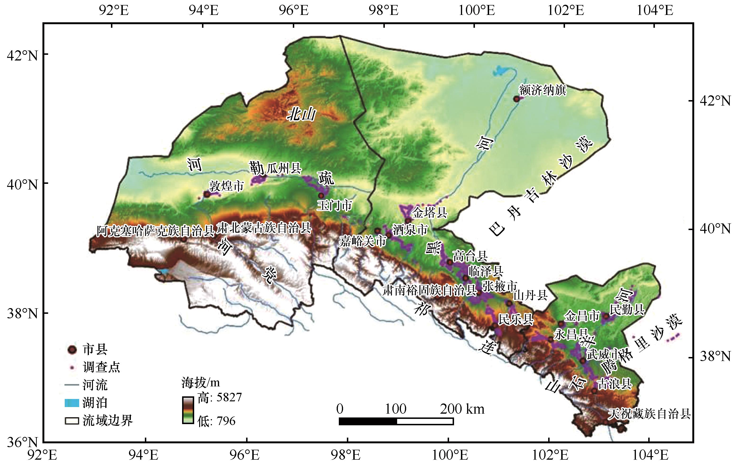
Fig. 1 The location of the study area
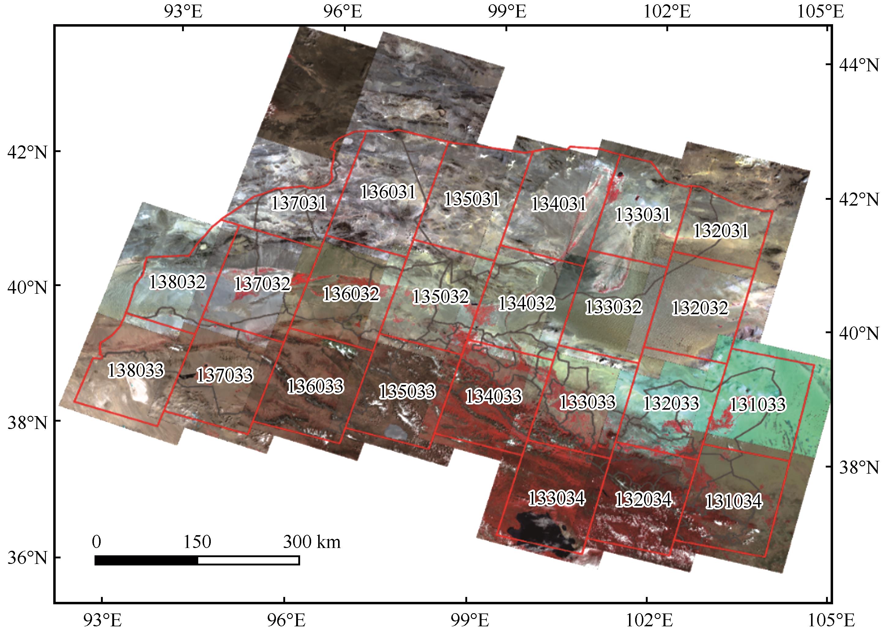
Fig. 2 The Landsat track number and 2020 OLI image in Hexi inland river basin
| 一级类型 | 特征描述及分布 | 二级类型 | 特征描述及分布 |
|---|---|---|---|
| 人工绿洲 | 位于荒漠基质背景下,植被生产力明显高于周围,耕地和建设用地是其主要土地覆被类型,绿洲外围和耕地周围有明显的条带状防护林草带 | 林地 | 以人工防护林为主,主要是防护人工绿洲遭到风沙侵害,与耕地或建设用地这样的典型类型相邻 |
| 草地 | 分布在绿洲内部,斑块较小,一般属于未开垦地或者撂荒地 | ||
| 耕地 | 人工绿洲的主体,呈规则的块状 | ||
| 湿地 | 人工绿洲内的坑塘、人工湿地、河渠等 | ||
| 建设用地 | 人工绿洲内的农村居民点、城镇用地及道路设施 | ||
| 未利用地 | 人工绿洲内斑块较小的未利用地,一般多为裸土、盐碱地等 | ||
| 荒漠-绿洲 过渡带 | 由于自然绿洲与荒漠没有明显的植被覆盖度降低的梯度,本研究中过渡带指的是人工绿洲和荒漠的中间地带。因此主要分布在荒漠和人工绿洲之间,以天然或半人工灌草为主,植被生产力明显低于人工绿洲,高于荒漠,通常植被覆盖度高于14% | 林地 | 分布在人工绿洲的外围,以天然或半人工林灌为主,有少量的人类活动痕迹 |
| 草地 | 分布在人工绿洲的外围,以天然或半人工草地为主,有少量的人类活动痕迹 | ||
| 湿地 | 分布在人工绿洲的外围,以天然湿地为主,遭受少量的人类活动影响 | ||
| 未利用地 | 过渡带内斑块较小的未利用地,一般不与山地-荒漠系统连接,多为裸土、盐碱地等 | ||
| 自然绿洲 | 主要分布在下游尾闾附近,主要是无人工干扰的林草灌等类型,有的具有一定面积的天然湿地。小部分位于河流两边,属于河岸林 | 林地 | 分布在流域下游或河流两侧,与人工绿洲的位置关系是在人工绿洲的下方向,一般是天然林灌,极少受到人类干扰 |
| 草地 | 分布在流域下游或河流两侧,与人工绿洲的位置关系是在人工绿洲的下方向,一般是天然旱生草地,极少受到人类干扰 | ||
| 湿地 | 分布在流域下游河流和尾闾湖泊及周围湿地 | ||
| 未利用地 | 自然绿洲内斑块较小的未利用地,一般不与山地-荒漠系统连接,多为裸土、盐碱地等 |
Table 3 Oasis ecosystem classification system based on ChinaCover data set
| 一级类型 | 特征描述及分布 | 二级类型 | 特征描述及分布 |
|---|---|---|---|
| 人工绿洲 | 位于荒漠基质背景下,植被生产力明显高于周围,耕地和建设用地是其主要土地覆被类型,绿洲外围和耕地周围有明显的条带状防护林草带 | 林地 | 以人工防护林为主,主要是防护人工绿洲遭到风沙侵害,与耕地或建设用地这样的典型类型相邻 |
| 草地 | 分布在绿洲内部,斑块较小,一般属于未开垦地或者撂荒地 | ||
| 耕地 | 人工绿洲的主体,呈规则的块状 | ||
| 湿地 | 人工绿洲内的坑塘、人工湿地、河渠等 | ||
| 建设用地 | 人工绿洲内的农村居民点、城镇用地及道路设施 | ||
| 未利用地 | 人工绿洲内斑块较小的未利用地,一般多为裸土、盐碱地等 | ||
| 荒漠-绿洲 过渡带 | 由于自然绿洲与荒漠没有明显的植被覆盖度降低的梯度,本研究中过渡带指的是人工绿洲和荒漠的中间地带。因此主要分布在荒漠和人工绿洲之间,以天然或半人工灌草为主,植被生产力明显低于人工绿洲,高于荒漠,通常植被覆盖度高于14% | 林地 | 分布在人工绿洲的外围,以天然或半人工林灌为主,有少量的人类活动痕迹 |
| 草地 | 分布在人工绿洲的外围,以天然或半人工草地为主,有少量的人类活动痕迹 | ||
| 湿地 | 分布在人工绿洲的外围,以天然湿地为主,遭受少量的人类活动影响 | ||
| 未利用地 | 过渡带内斑块较小的未利用地,一般不与山地-荒漠系统连接,多为裸土、盐碱地等 | ||
| 自然绿洲 | 主要分布在下游尾闾附近,主要是无人工干扰的林草灌等类型,有的具有一定面积的天然湿地。小部分位于河流两边,属于河岸林 | 林地 | 分布在流域下游或河流两侧,与人工绿洲的位置关系是在人工绿洲的下方向,一般是天然林灌,极少受到人类干扰 |
| 草地 | 分布在流域下游或河流两侧,与人工绿洲的位置关系是在人工绿洲的下方向,一般是天然旱生草地,极少受到人类干扰 | ||
| 湿地 | 分布在流域下游河流和尾闾湖泊及周围湿地 | ||
| 未利用地 | 自然绿洲内斑块较小的未利用地,一般不与山地-荒漠系统连接,多为裸土、盐碱地等 |
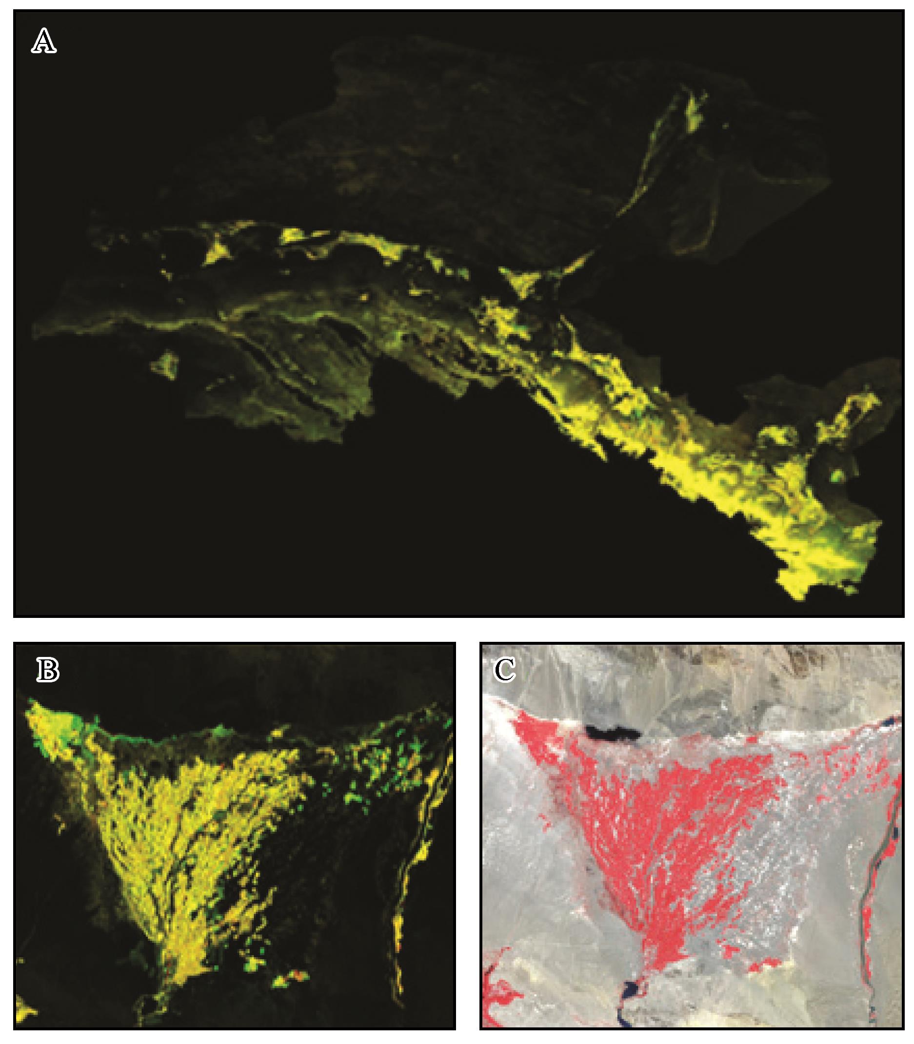
Fig. 3 Monitoring display of vegetation coverage changes in the study area during 2015-2020
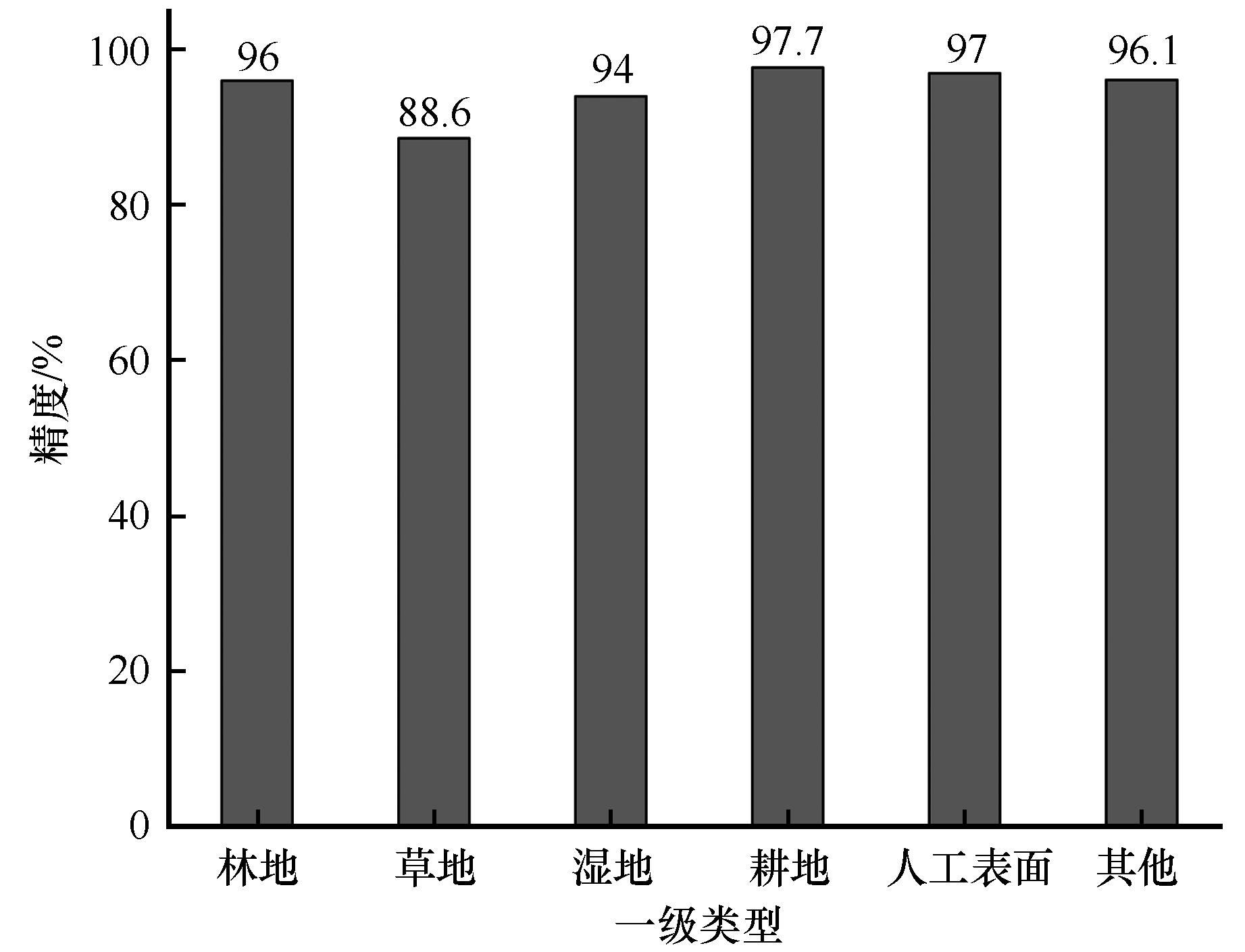
Fig. 4 Accuracy of the first-level type of land cover in the northern temperate arid area of ChinaCover product[46]
| 人工绿洲 | 自然绿洲 | 过渡带 | 山地荒漠 | 合计 | |
|---|---|---|---|---|---|
| 人工绿洲 | 669 | 3 | 5 | 1 | 678 |
| 自然绿洲 | 5 | 127 | 2 | 2 | 136 |
| 过渡带 | 8 | 7 | 83 | 5 | 103 |
| 山地荒漠 | 0 | 3 | 4 | 250 | 257 |
| 合计 | 682 | 140 | 94 | 258 | 1 174 |
| 用户精度 | 98.09% | 90.71% | 88.30% | 96.90% | |
| 制图精度 | 98.67% | 93.38% | 80.58% | 97.28% | |
| 总体精度 | 96.17% | ||||
| Kappa系数 | 0.936 |
Table 4 Confusion matrix for the classification results of the first-level types of oasis ecosystems in 2020
| 人工绿洲 | 自然绿洲 | 过渡带 | 山地荒漠 | 合计 | |
|---|---|---|---|---|---|
| 人工绿洲 | 669 | 3 | 5 | 1 | 678 |
| 自然绿洲 | 5 | 127 | 2 | 2 | 136 |
| 过渡带 | 8 | 7 | 83 | 5 | 103 |
| 山地荒漠 | 0 | 3 | 4 | 250 | 257 |
| 合计 | 682 | 140 | 94 | 258 | 1 174 |
| 用户精度 | 98.09% | 90.71% | 88.30% | 96.90% | |
| 制图精度 | 98.67% | 93.38% | 80.58% | 97.28% | |
| 总体精度 | 96.17% | ||||
| Kappa系数 | 0.936 |
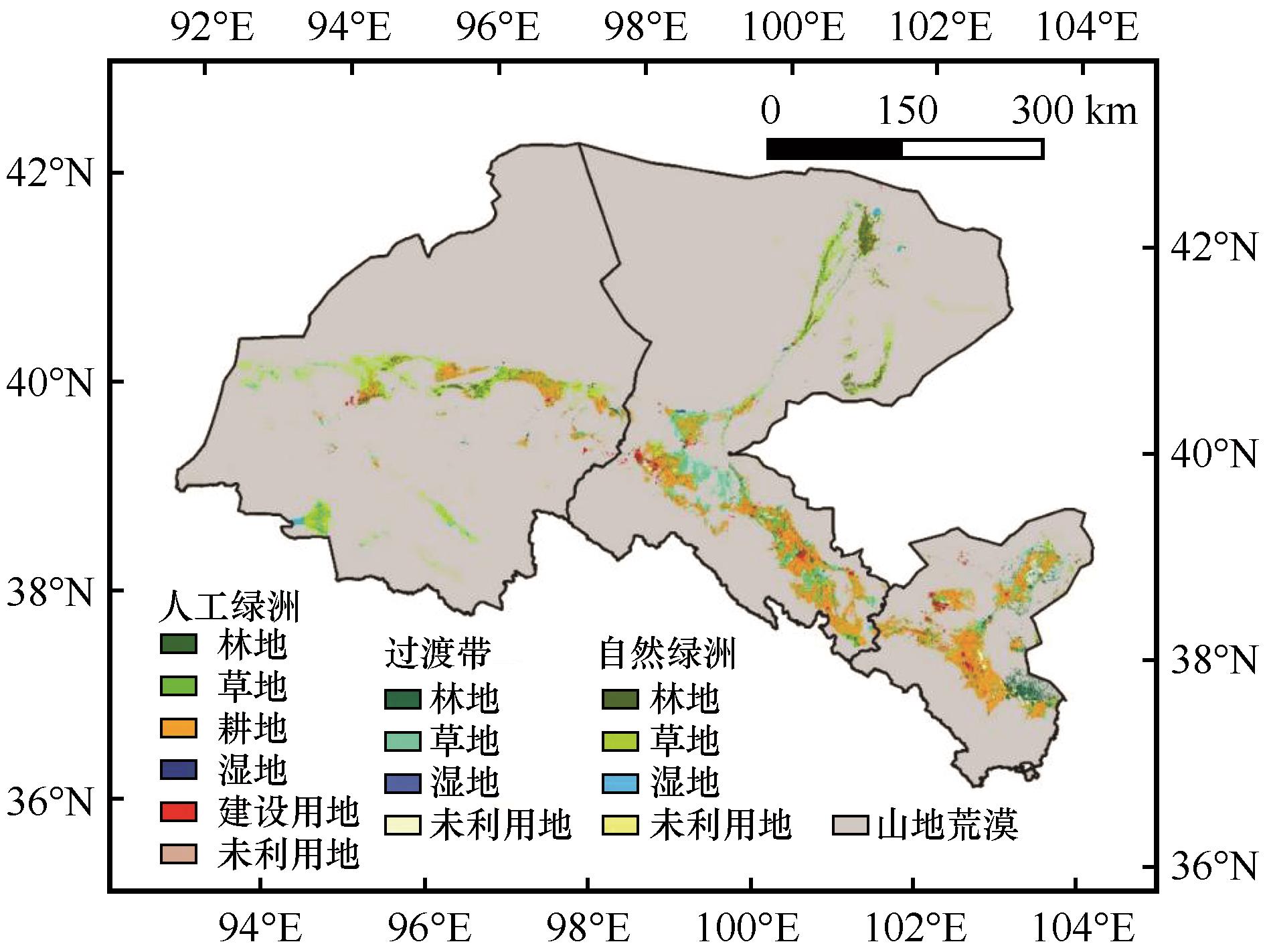
Fig 5 Spatial distribution of oasis in the Hexi inland river basin in 2020
| 一级类型 | 二级类型 | 1975年 | 1990年 | 2000年 | 2005年 | 2010年 | 2015年 | 2020年 |
|---|---|---|---|---|---|---|---|---|
| 人工绿洲 | 林地 | 526.45 | 544.69 | 645.09 | 700.98 | 754.30 | 848.70 | 902.43 |
| 草地 | 884.14 | 857.88 | 993.51 | 1 012.52 | 1 148.02 | 1 231.31 | 1 186.39 | |
| 耕地 | 11 016.00 | 11 315.92 | 12 083.39 | 12 760.85 | 12 858.57 | 13 032.21 | 13 333.13 | |
| 湿地 | 138.11 | 150.33 | 152.84 | 165.48 | 188.77 | 207.11 | 207.24 | |
| 建设用地 | 1 128.45 | 1 167.65 | 1 172.63 | 1 257.22 | 1 324.50 | 1 617.21 | 1 712.99 | |
| 未利用地 | 293.08 | 227.54 | 221.55 | 210.29 | 213.01 | 273.82 | 280.39 | |
| 小计 | 13 986.21 | 14 264.00 | 15 269.01 | 16 107.35 | 16 487.16 | 17 210.35 | 17 622.57 | |
| 过渡带 | 林地 | 1 273.93 | 1 260.92 | 1 218.73 | 1 186.06 | 1 125.18 | 1 101.01 | 1 103.84 |
| 草地 | 4 026.42 | 3 976.08 | 3 535.31 | 3 372.20 | 3 306.82 | 3 102.80 | 2 974.67 | |
| 湿地 | 39.70 | 35.25 | 33.34 | 28.10 | 27.94 | 28.46 | 32.71 | |
| 未利用地 | 1 581.86 | 1 582.40 | 1 403.74 | 1 380.55 | 1 112.49 | 1 066.98 | 1 059.53 | |
| 小计 | 6 921.90 | 6 854.65 | 6 191.13 | 5 966.92 | 5 572.43 | 5 299.25 | 5 170.76 | |
| 自然绿洲 | 林地 | 1 613.55 | 1 615.79 | 1 600.01 | 1 586.13 | 1 582.54 | 1 548.26 | 1 573.78 |
| 草地 | 4 814.36 | 4 807.38 | 4 739.16 | 4 602.05 | 4 558.62 | 4 535.54 | 4 593.83 | |
| 湿地 | 550.13 | 518.90 | 517.26 | 594.06 | 600.93 | 727.34 | 722.43 | |
| 未利用地 | 407.38 | 386.97 | 382.58 | 393.27 | 337.22 | 387.80 | 388.34 | |
| 小计 | 7 385.43 | 7 329.04 | 7 239.01 | 7 175.51 | 7 079.31 | 7 198.94 | 7 278.38 | |
| 总计 | 28 293.55 | 28 447.69 | 28 699.15 | 29 249.77 | 29 138.90 | 29 708.55 | 30 071.71 | |
Table 5 Area of Oasis land cover types from 1975 to 2020 (km2 )
| 一级类型 | 二级类型 | 1975年 | 1990年 | 2000年 | 2005年 | 2010年 | 2015年 | 2020年 |
|---|---|---|---|---|---|---|---|---|
| 人工绿洲 | 林地 | 526.45 | 544.69 | 645.09 | 700.98 | 754.30 | 848.70 | 902.43 |
| 草地 | 884.14 | 857.88 | 993.51 | 1 012.52 | 1 148.02 | 1 231.31 | 1 186.39 | |
| 耕地 | 11 016.00 | 11 315.92 | 12 083.39 | 12 760.85 | 12 858.57 | 13 032.21 | 13 333.13 | |
| 湿地 | 138.11 | 150.33 | 152.84 | 165.48 | 188.77 | 207.11 | 207.24 | |
| 建设用地 | 1 128.45 | 1 167.65 | 1 172.63 | 1 257.22 | 1 324.50 | 1 617.21 | 1 712.99 | |
| 未利用地 | 293.08 | 227.54 | 221.55 | 210.29 | 213.01 | 273.82 | 280.39 | |
| 小计 | 13 986.21 | 14 264.00 | 15 269.01 | 16 107.35 | 16 487.16 | 17 210.35 | 17 622.57 | |
| 过渡带 | 林地 | 1 273.93 | 1 260.92 | 1 218.73 | 1 186.06 | 1 125.18 | 1 101.01 | 1 103.84 |
| 草地 | 4 026.42 | 3 976.08 | 3 535.31 | 3 372.20 | 3 306.82 | 3 102.80 | 2 974.67 | |
| 湿地 | 39.70 | 35.25 | 33.34 | 28.10 | 27.94 | 28.46 | 32.71 | |
| 未利用地 | 1 581.86 | 1 582.40 | 1 403.74 | 1 380.55 | 1 112.49 | 1 066.98 | 1 059.53 | |
| 小计 | 6 921.90 | 6 854.65 | 6 191.13 | 5 966.92 | 5 572.43 | 5 299.25 | 5 170.76 | |
| 自然绿洲 | 林地 | 1 613.55 | 1 615.79 | 1 600.01 | 1 586.13 | 1 582.54 | 1 548.26 | 1 573.78 |
| 草地 | 4 814.36 | 4 807.38 | 4 739.16 | 4 602.05 | 4 558.62 | 4 535.54 | 4 593.83 | |
| 湿地 | 550.13 | 518.90 | 517.26 | 594.06 | 600.93 | 727.34 | 722.43 | |
| 未利用地 | 407.38 | 386.97 | 382.58 | 393.27 | 337.22 | 387.80 | 388.34 | |
| 小计 | 7 385.43 | 7 329.04 | 7 239.01 | 7 175.51 | 7 079.31 | 7 198.94 | 7 278.38 | |
| 总计 | 28 293.55 | 28 447.69 | 28 699.15 | 29 249.77 | 29 138.90 | 29 708.55 | 30 071.71 | |
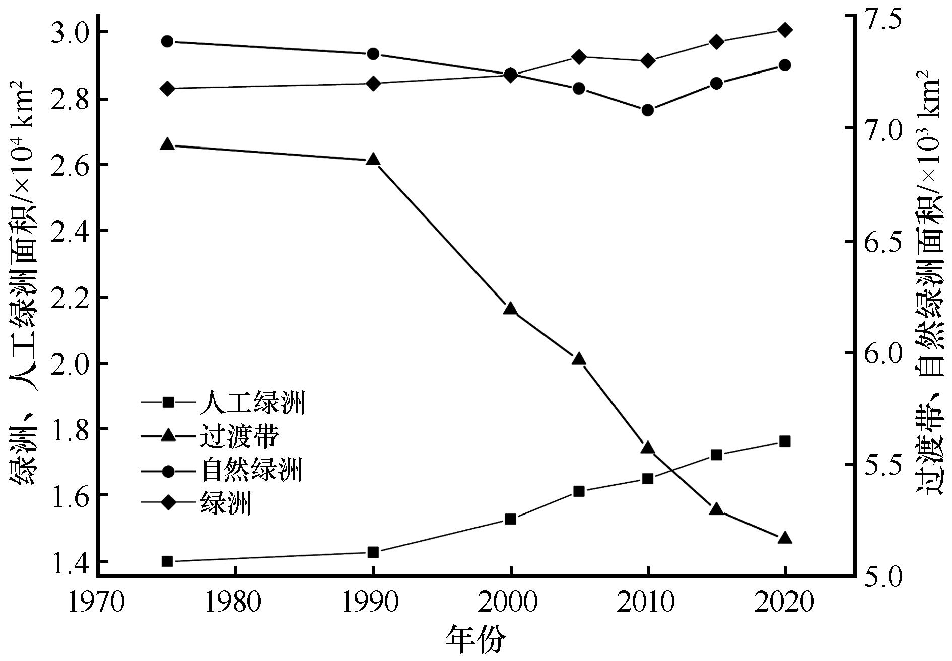
Fig. 6 Changes of oasis area in Hexi inland river basin from 1975 to 2020
| 类型 | FROM-GLC数据 | 本研究绿洲二级类数据 | ||
|---|---|---|---|---|
| 制图精度 | 用户精度 | 制图精度 | 用户精度 | |
| 农田 | 72.36% | 81.65% | 92.19% | 95.93% |
| 林地 | 14.29% | 57.14% | 87.04% | 90.38% |
| 草地 | 47.27% | 40.00% | 79.17% | 63.33% |
| 建设用地 | 0.00% | 0.00% | 100.00% | 100.00% |
| 湿地 | 94.74% | 85.71% | 94.74% | 100.00% |
| 未利用地 | 88.24% | 29.41% | 76.47% | 68.42% |
| 总体 | 60.08% | 89.33% | ||
| Kappa系数 | 0.439 | 0.845 | ||
Table 6 The comparison of the accuracy on between this data product and FROM-GLC data
| 类型 | FROM-GLC数据 | 本研究绿洲二级类数据 | ||
|---|---|---|---|---|
| 制图精度 | 用户精度 | 制图精度 | 用户精度 | |
| 农田 | 72.36% | 81.65% | 92.19% | 95.93% |
| 林地 | 14.29% | 57.14% | 87.04% | 90.38% |
| 草地 | 47.27% | 40.00% | 79.17% | 63.33% |
| 建设用地 | 0.00% | 0.00% | 100.00% | 100.00% |
| 湿地 | 94.74% | 85.71% | 94.74% | 100.00% |
| 未利用地 | 88.24% | 29.41% | 76.47% | 68.42% |
| 总体 | 60.08% | 89.33% | ||
| Kappa系数 | 0.439 | 0.845 | ||
| 一级类型 | 二级类型 | 本数据 | oasis_wang | oasis_xie |
|---|---|---|---|---|
| 人工绿洲 | 林地 | 754.3 | 629.61 | — |
| 草地 | 1 148.02 | 786.2 | — | |
| 耕地 | 12 858.57 | 10 262.61 | — | |
| 湿地 | 188.77 | 301.54 | — | |
| 建设用地 | 1 324.5 | 1 395.94 | — | |
| 未利用地 | 213.01 | 208.15 | — | |
| 小计 | 16 487.16 | 13 584.05 | 14 410.73 |
Table 7 Comparison of the area of artificial oases in our data with other data products (2010, Unit: km2 )
| 一级类型 | 二级类型 | 本数据 | oasis_wang | oasis_xie |
|---|---|---|---|---|
| 人工绿洲 | 林地 | 754.3 | 629.61 | — |
| 草地 | 1 148.02 | 786.2 | — | |
| 耕地 | 12 858.57 | 10 262.61 | — | |
| 湿地 | 188.77 | 301.54 | — | |
| 建设用地 | 1 324.5 | 1 395.94 | — | |
| 未利用地 | 213.01 | 208.15 | — | |
| 小计 | 16 487.16 | 13 584.05 | 14 410.73 |
| 1 | 申元村.拓展中国绿洲研究,促进干旱区域可持续发展[J].干旱区研究,2007(4):415. |
| 2 | 王涛.干旱区绿洲化、荒漠化研究的进展与趋势[J].中国沙漠,2009,29(1):1-9. |
| 3 | 赵文智,庄艳丽.中国干旱区绿洲稳定性研究[J].干旱区研究,2008(2):155-162. |
| 4 | 王玉洁,秦大河.气候变化及人类活动对西北干旱区水资源影响研究综述[J].气候变化研究进展,2017,13(5):483-493. |
| 5 | Jia B, Zhang Z, Ci L,et al.Oasis land-use dynamics and its influence on the oasis environment in Xinjiang,China[J].Journal of Arid Environments,2004,56(1):11-26. |
| 6 | 巩杰,谢余初,高彦净,等.1963-2009年金塔绿洲变化对绿洲景观格局的影响[J].生态学报,2015,35(3):603-612. |
| 7 | 王新源,刘世增,陈翔舜,等.河西走廊绿洲面积动态及其驱动因素[J].中国沙漠,2019,39(4):212-219. |
| 8 | Bie Q, Xie Y.The constraints and driving forces of oasis development in arid region:a case study of the Hexi Corridor in northwest China[J].Scientific Reports,2020,10:17708. |
| 9 | Xie Y, Bie Q, Lu H,et al.Spatio-temporal changes of oases in the Hexi Corridor over the past 30 years[J].Sustainability,2018,10:4489. |
| 10 | 卫娇娇.基于遥感的甘肃河西地区绿洲分布提取及时空变化分析[D].兰州:兰州大学,2016. |
| 11 | 李森,颜长珍.近20年来河西走廊人工绿洲演变及人为因素分析[J].干旱区资源与环境,2013,27(4):92-98. |
| 12 | 赵文智,杨荣,刘冰,等.中国绿洲化及其研究进展[J].中国沙漠,2016,36(1):1-5. |
| 13 | 陈曦,罗格平.干旱区绿洲生态研究及其进展[J].干旱区地理,2008(4):487-495. |
| 14 | 赵文智,常学礼.河西走廊水文过程变化对荒漠绿洲过渡带NDVI的影响[J].中国科学:地球科学,2014,44(7):1561-1571. |
| 15 | 武磊,李常斌,王刘明,等.基于ESA-LUC和MODIS-NDVI的西北干旱荒漠-绿洲体系分类阈值及应用[J].中国沙漠,2020,40(6):139-150. |
| 16 | Foley J A, DeFries R, Asner G P,et al.Global consequences of land use[J].Science,2005,309(5734):570-574. |
| 17 | Running S W.Ecosystem disturbance,carbon,and climate[J].Science,2008,321(5889):652-653. |
| 18 | Gong P, Wang J, Yu L,et al.Finer resolution observation and monitoring of global land cover:first mapping results with Landsat TM and ETM+ data[J].International Journal of Remote Sensing,2013,34(7):2607-2654. |
| 19 | Zhang Z, Wang X, Zhao X,et al.A 2010 update of National Land Use/Cover Database of China at 1∶100000 scale using medium spatial resolution satellite images[J].Remote Sensing of Environment,2014,149:142-154. |
| 20 | Yang Y, Xiao P, Feng X,et al.Accuracy assessment of seven global land cover datasets over China[J].ISPRS Journal of Photogrammetry and Remote Sensing,2017,125:156-173. |
| 21 | Chen J, Zhu X, Imura H,et al.Consistency of accuracy assessment indices for soft classification:Simulation analysis [J].ISPRS Journal of Photogrammetry and Remote Sensing,2010,65:156-164. |
| 22 | Fei C, Jun C, Hao W,et al.A landscape shape index-based sampling approach for land cover accuracy assessment[J].Science China (Earth Sciences),2016,59(12):2263-2274. |
| 23 | Loveland T R, Belward A S.The IGBP-DIS global 1 km land cover data set,DISCover:first results[J].International Journal of Remote Sensing,1997,18(15):3289-3295. |
| 24 | Loveland T R, Reed B C, Brown J F,et al.Development of a global land cover characteristics database and IGBP DISCover from 1 km AVHRR data[J].International Journal of Remote Sensing,2000,21(6/7):1303-1330. |
| 25 | Hansen M C, Defries R S, Townshend J R G,et al.Global land cover classification at 1 km spatial resolution using a classification tree approach[J].International Journal of Remote Sensing,2000,21(6/7):1331-1364. |
| 26 | Bartholome E, Belward A S.GLC2000:a new approach to global land cover mapping from Earth observation data[J].International Journal of Remote Sensing,2005,26(9):1959-1977. |
| 27 | Friedl M A, Mciver D K, Hodges J C F,et al.Global land cover mapping from MODIS:algorithms and early results[J].Remote Sensing of Environment,2002,83(1/2):287-302. |
| 28 | Friedl M A, Sulla-Menashe D, Tan B,et al.MODIS Collection 5 global land cover:algorithm refinements and characterization of new datasets[J].Remote Sensing of Environment,2010,114(1):168-182. |
| 29 | Arino O, Bicheron P, Achard F,et al.GLOBCOVER:the most detailed portrait of Earth[J].ESA Bulletin,2008,136:25-31. |
| 30 | Bontemps S, Defourny P, Van Bogaert E,et al.GLOBCOVER 2009 products description and validation report[J].Foro Mundial De La Salud,2011,136(53):10013. |
| 31 | Defourny P, Achard F, Boettcher M,et al.Global and regional land cover mapping and characterization for climate modelling:current achievements of the Land Cover component of the ESA Climate Change Initiative[C]//Living Planet Symposium 2016.Prague,Czech,2016. |
| 32 | Tateishi R, Hoan N T, Kobayashi T,et al.Production of global land cover data-GLCNMO2008[J].Journal of Geography Geology,2014,6(3):99. |
| 33 | Yu L, Wang J, Gong P.Improving 30 m global land-cover map FROM-GLC with time series MODIS and auxiliary data sets:a segmentation-based approach[J].International Journal of Remote Sensing,2013,34(16):5851-5867. |
| 34 | Karra K, Kontgis C, Statman-Weil Z,et al.Global land use / land cover with Sentinel 2 and deep learning[J].IEEE International Geoscience and Remote Sensing Symposium IGARSS,2021:4704-4707. |
| 35 | Chen J, Chen J, Liao A,et al.Global land cover mapping at 30 m resolution:a POK-based operational approach [J].ISPRS Journal of Photogrammetry and Remote Sensing,2015,103:7-27. |
| 36 | 吴炳方,张淼.从遥感观测数据到数据产品[J].地理学报,2017,72(11):2093-2111. |
| 37 | 张磊,吴炳方,李晓松,等.基于碳收支的中国土地覆被分类系统[J].生态学报,2014,34(24):7158-7166. |
| 38 | 张济世.河西内陆河流域水资源与现代生态环境演变[D].北京:中国科学院研究生院,2003. |
| 39 | 王金强,李俊峰,王昭阳,等.基于像元二分模型的典型绿洲区近20年植被覆盖变化及分析[J].节水灌溉,2019(1):96-101. |
| 40 | 廖杰,王涛,薛娴.近55 a来黑河流域绿洲演变特征的初步研究[J].中国沙漠,2012,32(5):1426-1441. |
| 41 | 谢家丽,颜长珍,李森,等.近35 a内蒙古阿拉善盟绿洲化过程遥感分析[J].中国沙漠,2012,32(4):1142-1147. |
| 42 | Ge G, Shi Z, Zhu Y,et al.Land use/cover classification in an arid desert-oasis mosaic landscape of China using remote sensed imagery:performance assessment of four machine learning algorithms[J].Global Ecology and Conservation,2020,22:e00971. |
| 43 | 顾峰,丁建丽,王敬哲,等.基于随机森林的绿洲典型湿地信息提取[J].中国农村水利水电,2019(6):44-50. |
| 44 | 卡地尔牙·忙苏尔,依力亚斯江·努尔麦麦提,张永福,等.基于多特征PolSAR数据的干旱区土地利用/覆被分类[J].地理空间信息,2021,19(12):40-44. |
| 45 | 廖杰.黑河流域绿洲演变研究[D].北京:中国科学院研究生院,2011. |
| 46 | 吴炳方.中华人民共和国土地覆被地图集(1∶1 000 000)[M].北京:中国地图出版社,2017. |
| 47 | Li S, Zhang Z, Wang T,et al.Oasis functional stability evaluation based on multiple indicators,northwest China[J].Acta Geologica Sinica (English Edition),2020,94(3):624-636. |
| [1] | Haotian Yang, Xinrong Li, Peijie Yan, Yunfei Li, Quanlin Ma. Soil types and spatial distribution in Tengger Desert [J]. Journal of Desert Research, 2020, 40(4): 154-162. |
| [2] | Zhang Meiling, Jiang Wenlan, Cheng Quangong, Liu Xiaoni. Estimation of Grassland Net Primary Production in China with Improved CASA Model Based on the CSCS [J]. JOURNAL OF DESERT RESEARCH, 2014, 34(4): 1150-1160. |
| [3] | FENG Yi-ming, WU Bo, ZHOU Na, CHE Teng-teng, WANG Feng, CONG Ri-chun, CAO Yan-li, LU Qi. Gobi Classification System Based on Remote Sensing Image Recognition [J]. JOURNAL OF DESERT RESEARCH, 2013, 33(3): 635-641. |
| [4] | DONG Yu-xiang. Classification of Coastal Dunes in Temperate Zone in China [J]. JOURNAL OF DESERT RESEARCH, 2000, 20(2): 159-165. |
| [5] | LIU Shu-zhen, CHAI Zong-xin, FAN Jian-rong. Discussion on Classification System of Land Desertification in China [J]. JOURNAL OF DESERT RESEARCH, 2000, 20(1): 35-39. |
| [6] | LI Sen, WANG Yue, HA Si, YANG Ping, JIN He-ling, ZHANG Jia-shen. CLASSIFICATION AND DEVELOPMENT OF AEOLIAN SAND LANDFORM IN THE YURLUNG ZANGBO VALLEY [J]. JOURNAL OF DESERT RESEARCH, 1997, 17(4): 342-350. |
| Viewed | ||||||
|
Full text |
|
|||||
|
Abstract |
|
|||||
©2018Journal of Desert Research
Tel:0931-8267545
Email:caiedit@lzb.ac.cn;desert@lzb.ac.cn
Support:Magtech