
- CN 62-1070/P
- ISSN 1000-694X
- Bimonthly 1981
Journal of Desert Research ›› 2026, Vol. 46 ›› Issue (2): 1-10.DOI: 10.7522/j.issn.1000-694X.2025.00055
Jie Gao( ), Guangyin Hu(), Na Gao, Jingjing Hu
Received:2025-02-08
Revised:2025-04-17
Online:2026-03-20
Published:2026-04-13
Contact:
Guangyin Hu
CLC Number:
Jie Gao, Guangyin Hu, Na Gao, Jingjing Hu. Remote sensing monitoring of aeolian sediments on the lake ice surface of Zonag Lake from 2017 to 2018[J]. Journal of Desert Research, 2026, 46(2): 1-10.
Add to citation manager EndNote|Ris|BibTeX
URL: http://www.desert.ac.cn/EN/10.7522/j.issn.1000-694X.2025.00055
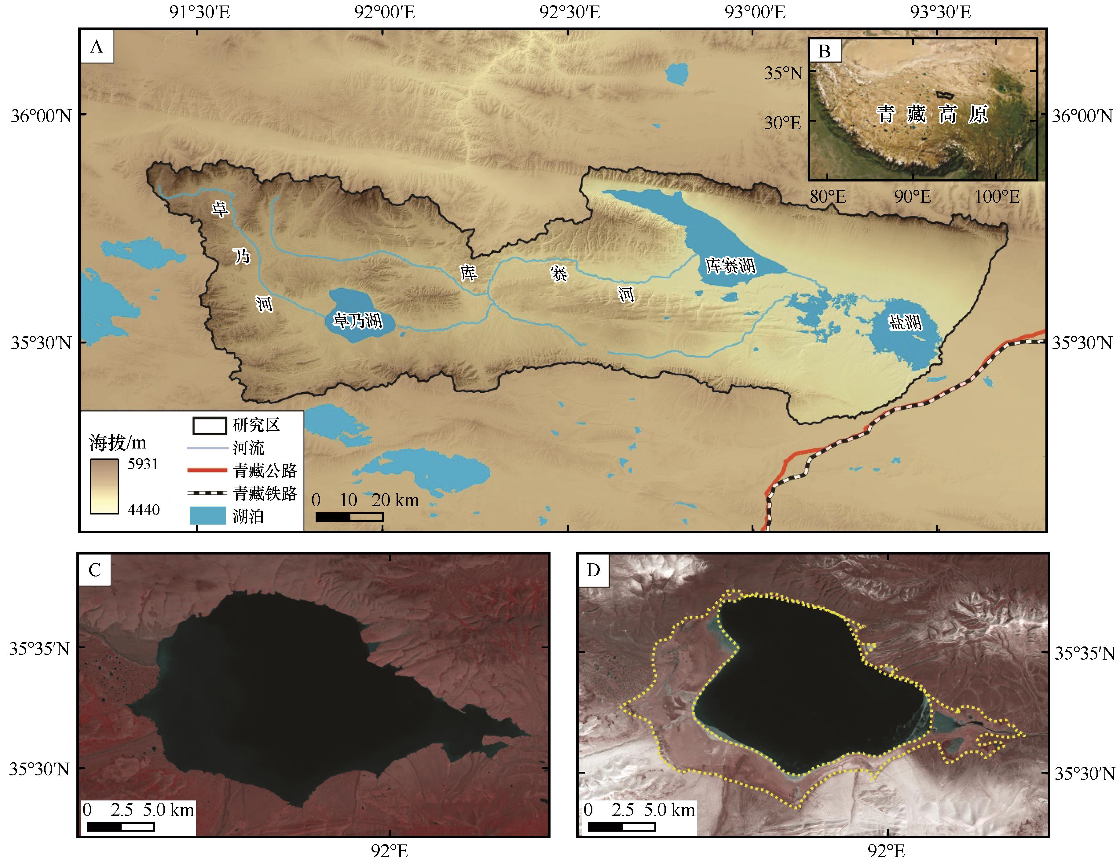
Fig.1 Topographic map (A) and location (B) of the Zonag Lake-Salt Lake basin, and Landsat TM images of August 30, 2009 (C) and November 8, 2011 (D) of Zonag Lake
| 序号 | 日期 | 数据源 | 空间分辨率/m |
|---|---|---|---|
| 1 | 2017-10-07 | Landsat 8 OLI | 30 |
| 2 | 2017-11-08 | Landsat 8 OLI | 30 |
| 3 | 2017-11-24 | Landsat 8 OLI | 30 |
| 4 | 2017-12-10 | Landsat 8 OLI | 30 |
| 5 | 2017-12-26 | Landsat 8 OLI | 30 |
| 6 | 2018-01-11 | Landsat 8 OLI | 30 |
| 7 | 2018-02-12 | Landsat 8 OLI | 30 |
| 8 | 2018-03-12 | GF1 | 16 |
| 9 | 2018-04-01 | Landsat 8 OLI | 30 |
| 10 | 2018-05-03 | Landsat 8 OLI | 30 |
| 11 | 2018-06-04 | Landsat 8 OLI | 30 |
Table 1 Remote sensing data
| 序号 | 日期 | 数据源 | 空间分辨率/m |
|---|---|---|---|
| 1 | 2017-10-07 | Landsat 8 OLI | 30 |
| 2 | 2017-11-08 | Landsat 8 OLI | 30 |
| 3 | 2017-11-24 | Landsat 8 OLI | 30 |
| 4 | 2017-12-10 | Landsat 8 OLI | 30 |
| 5 | 2017-12-26 | Landsat 8 OLI | 30 |
| 6 | 2018-01-11 | Landsat 8 OLI | 30 |
| 7 | 2018-02-12 | Landsat 8 OLI | 30 |
| 8 | 2018-03-12 | GF1 | 16 |
| 9 | 2018-04-01 | Landsat 8 OLI | 30 |
| 10 | 2018-05-03 | Landsat 8 OLI | 30 |
| 11 | 2018-06-04 | Landsat 8 OLI | 30 |
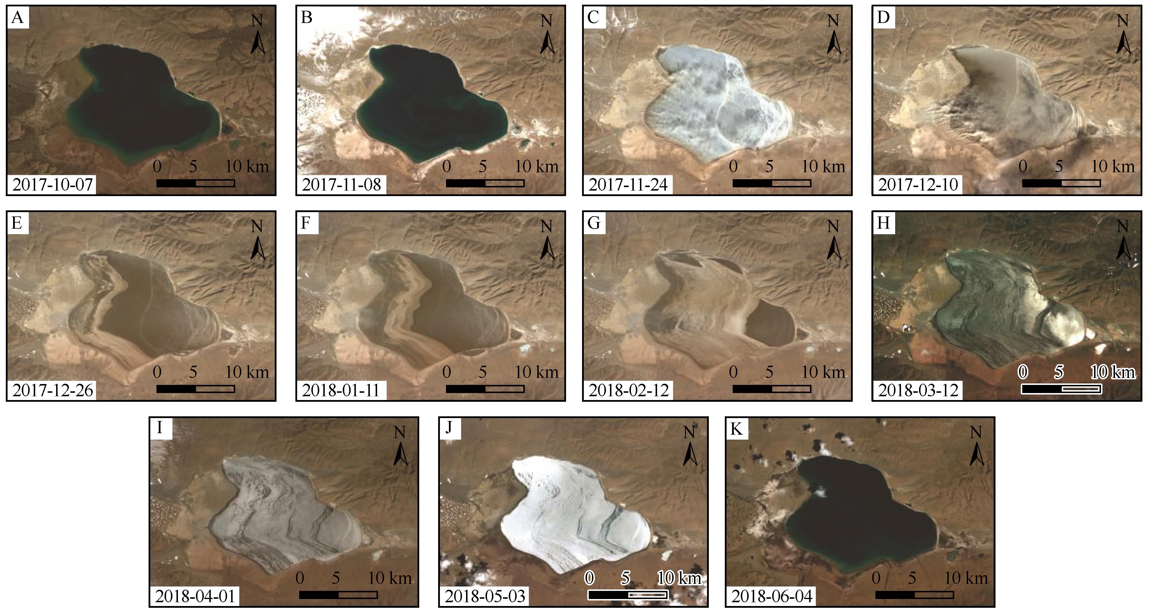
Fig.2 Landsat 8 OLI and GF1 remote sensing imagery of Zonag Lake
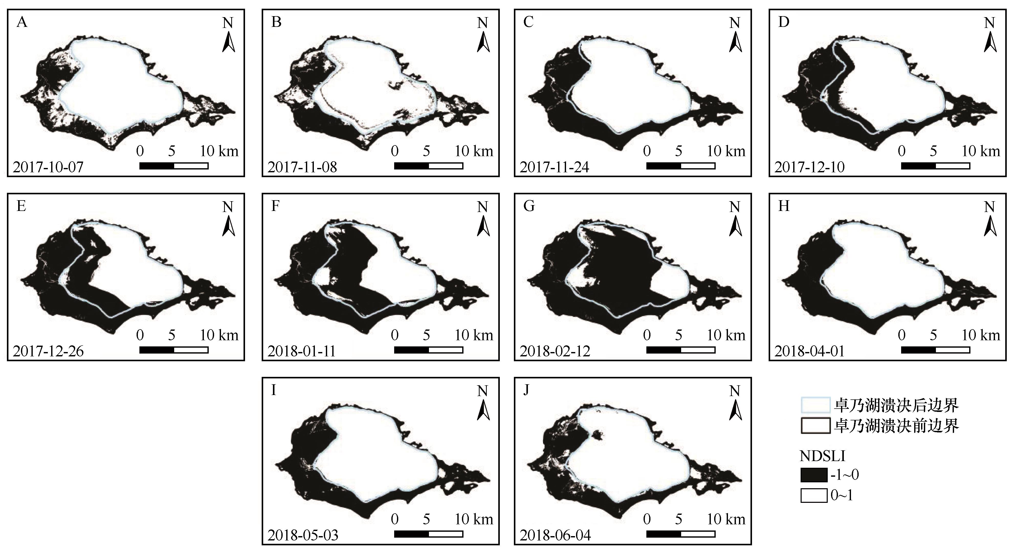
Fig.3 Preliminary threshold classification of NDSLI calculations
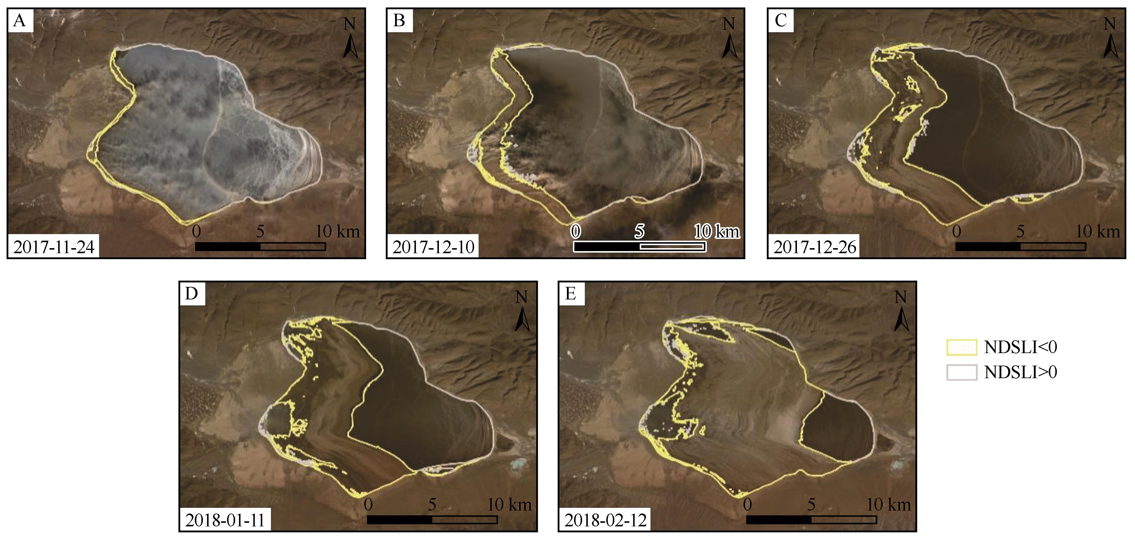
Fig.4 Comparison of preliminary thresholding results with the original image
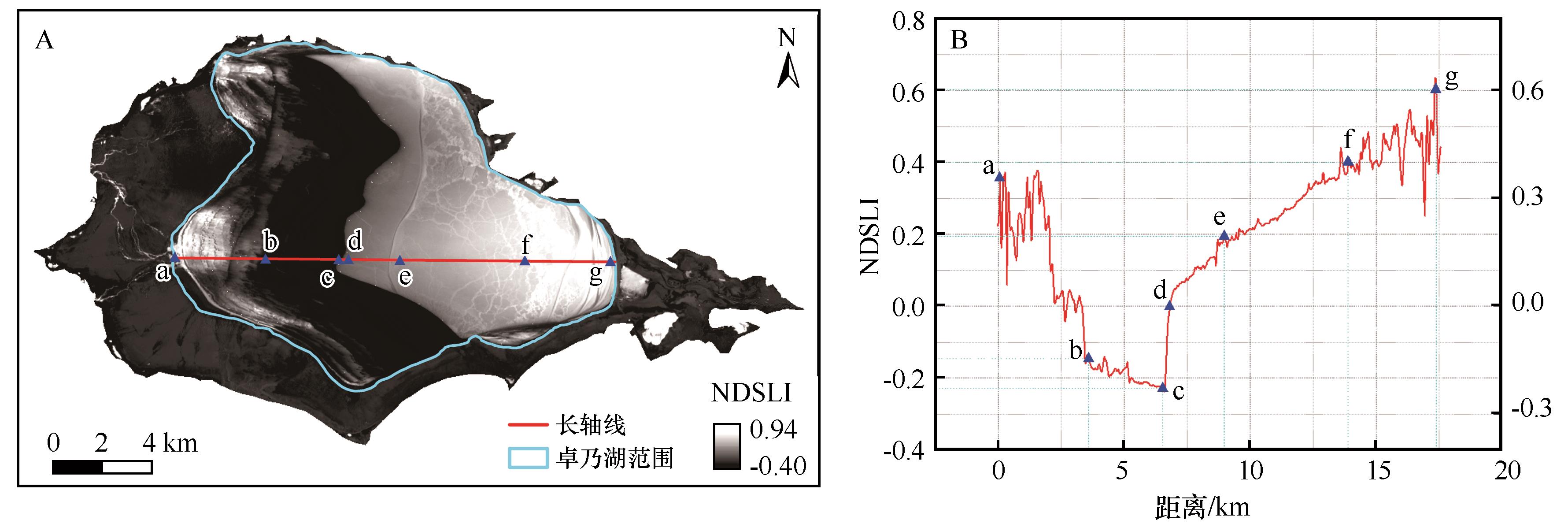
Fig.5 Profile of NDSLI values (B) along the vector line on the lake (A)
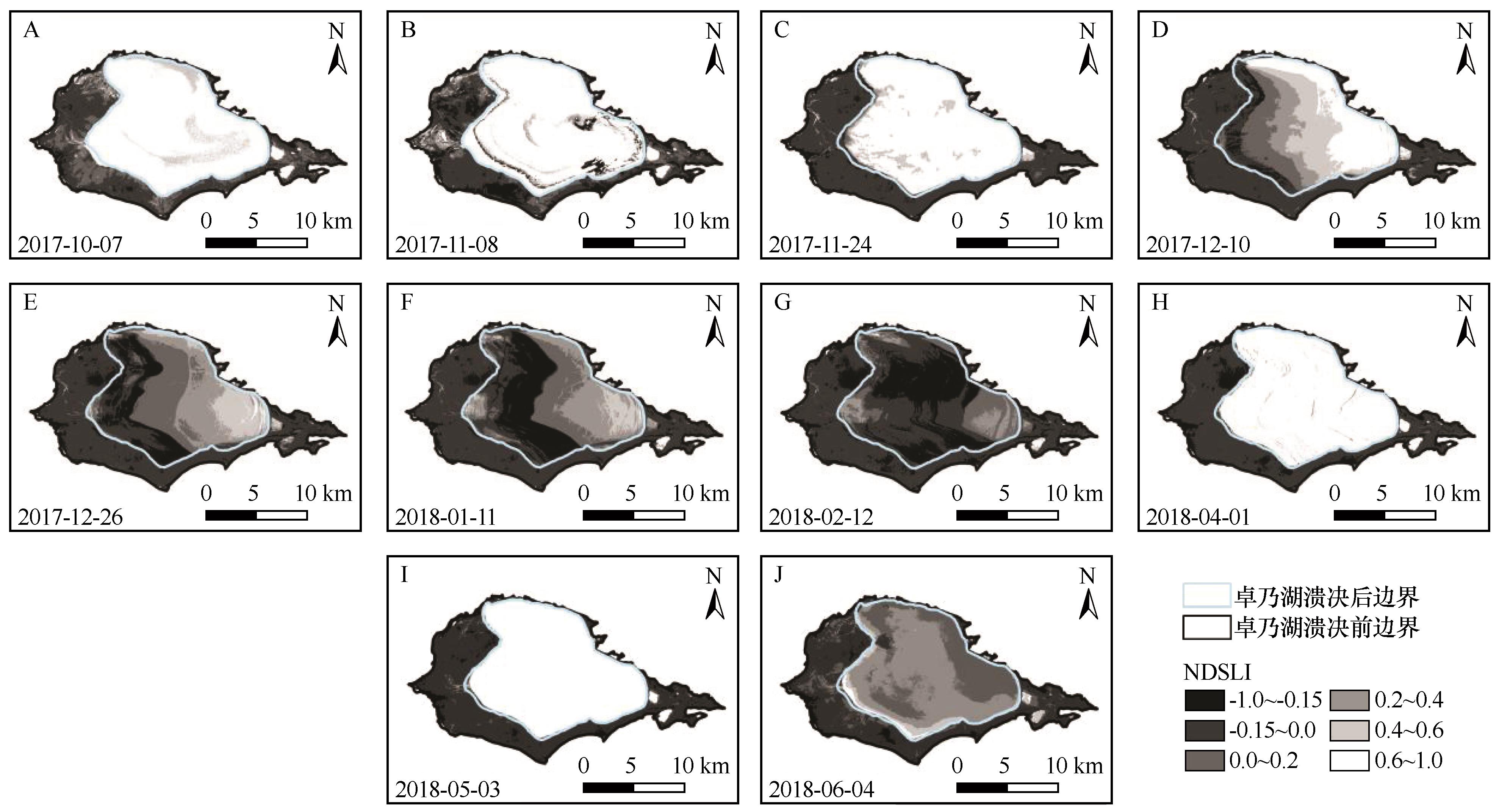
Fig.6 NDSLI calculations result in further threshold divisions
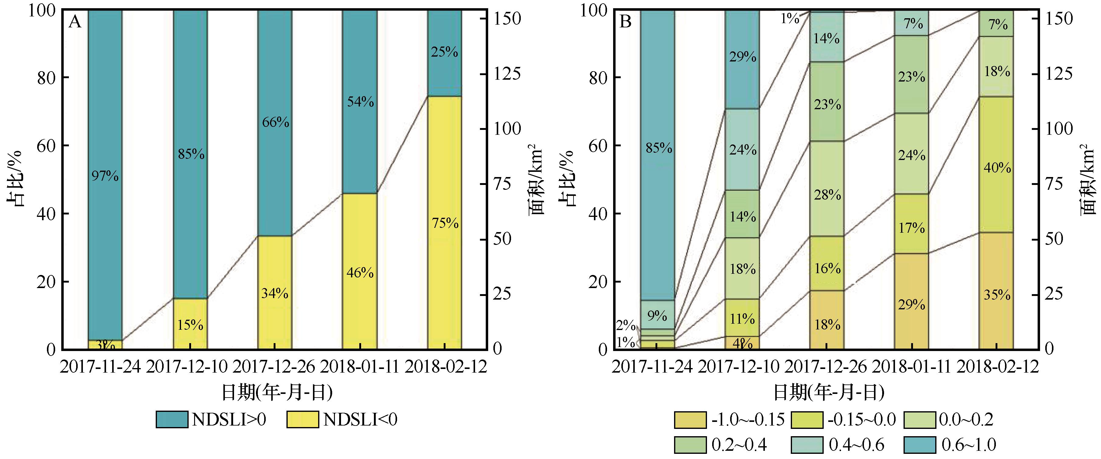
Fig.7 Area and percentage of non-sediment areas versus sediment areas (A), and each range of the reclassification thresholds (B)
| [1] | D'Almeida G A.A model for Saharan dust transport[J].Journal of Applied Meteorology,1986,25(7):903-916. |
| [2] | Du H Q, Wang T, Xue X,et al.Modelling of sand/dust emission in Northern China from 2001 to 2014[J].Geoderma,2018,330:162-176. |
| [3] | Gillette D A, Hanson K J.Spatial and temporal variability of dust production caused by wind erosion in the United States[J].Journal of Geophysical Research Atmospheres,1989,94(D2):2197-2206. |
| [4] | 景可,陈永宗.我国土壤侵蚀与地理环境的关系[J].地理研究,1990,9(2):29-38. |
| [5] | Roskin J, Porat N, Tsoar H,et al.Age,origin and climatic controls on vegetated linear dunes in the northwestern Negev Desert(Israel)[J].Quaternary Science Reviews,2011,30(13):1649-1674. |
| [6] | Zhang Z C, Pan K J, Zhang C X,et al.Geochemical characteristics and the provenance of aeolian material in the Hexi Corridor Desert,China[J].CATENA,2020,190:104483. |
| [7] | 范亚伟,杜鹤强,卢善龙,等.长江源卓乃湖流域沙尘释放过程模拟[J].地理科学,2023,43(12):2247-2256. |
| [8] | 刘东伟,吉力力·阿不都外力,穆桂金,等.艾比湖干涸湖底化学组成及盐尘的风运堆积[J].中国环境科学,2009,29(2):157-162. |
| [9] | 于海云,张正偲,王志军.阿拉善高原东南部干涸湖盆沉积物粒度特征[J].中国沙漠,2021,41(4):177-184. |
| [10] | Muhs D R, Reynolds R L, Been J,et al.Eolian sand transport pathways in the southwestern United States:importance of the Colorado River and local sources[J].Quaternary International,2003,104(1):3-18. |
| [11] | Draut A E.Effects of river regulation on aeolian landscapes,Colorado River,southwestern USA[J].Journal of Geophysical Research,2012,117(F2):F02022. |
| [12] | Du H Q, Wang T, Xue X,et al.Modern eolian and fluvial processes and their interactions in an ephemeral desert stream in Inner Mongolia,China[J].Journal of Soils and Sediments,2019,20(2):1140-1156. |
| [13] | Hu G Y, Hu J J, Dong Z B,et al.Seasonal ice-covered lake surface likely caused the spatial heterogeneity of aeolian sediment grain-size in the source region of Yellow River,northeastern Tibetan Plateau,China[J].Frontiers in Earth Science,2023,1150585. |
| [14] | 段安民,肖志祥,吴国雄.1979-2014年全球变暖背景下青藏高原气候变化特征[J].气候变化研究进展,2016,12(5):374-381. |
| [15] | 张国庆.青藏高原湖泊变化遥感监测及其对气候变化的响应研究进展[J].地理科学进展,2018,37(2):214-223. |
| [16] | Lu S L, Chen F, Zhou J F,et al.Cascading implications of a single climate change event for fragile ecosystems on the Qinghai-Tibetan Plateau[J].Ecosphere,2020,11(9):e03243. |
| [17] | Liu B K, Du Y, Li L,et al.Outburst flooding of the moraine-dammed Zhuonai Lake on Tibetan Plateau:causes and impacts[J].IEEE Geoscience and Remote Sensing Letters,2016,23(4):570-574. |
| [18] | Lu S L, Jin J M, Zhou J F,et al.Drainage basin reorganization and endorheic-exorheic transition triggered by climate change and human intervention[J].Global and Planetary Change,2021,201:103494. |
| [19] | 谢昌卫,张钰鑫,刘文惠,等.可可西里卓乃湖溃决后湖区环境变化及盐湖可能的溃决方式[J].冰川冻土,2020,42(4):1344-1352. |
| [20] | 姚晓军,刘时银,孙美平,等.可可西里地区库赛湖变化及湖水外溢成因[J].地理学报,2012,67(5):689-698. |
| [21] | 白虎志,董安祥,李栋梁,等.青藏高原及青藏铁路沿线大风沙尘日数时空特征[J].高原气象,2005(3):311-315. |
| [22] | Dong Z B, Hu G Y, Qian G Q,et al.High-altitude aeolian research on the Tibetan Plateau[J].Reviews of Geophysics,2017,55(4):864-901. |
| [23] | Fadhil A M.Sand dunes monitoring using remote sensing and GIS techniques for some sites in Iraq[C]//Proceedings of SPIE:The International Society for Optical Engineering.2013:8762. |
| [24] | Fadhil A M.Land degradation detection using geo-information technology for some sites in Iraq[J].Journal of AlNahrain University-Science,2009,12(3):94-108. |
| [25] | Deng Y B, Wu C S, Li M,et al.RNDSI:a ratio normalized difference soil index for remote sensing of urban/suburban environments[J].International Journal of Applied Earth Observation and Geoinformation,2015,39:40-48. |
| [26] | Pan X, Zhu X, Yang Y B,et al.Applicability of downscaling land surface temperature by using normalized difference sand index[J].Scientific Reports,2018,8(1):1-14. |
| [27] | Sahar A A, Alhadithi A A, Hassan M A,et al.Integrated remote sensing and GIS for developed new spectral index for estimating Sandy land and its potential hazards.case study:North-east Al-Muthanna Province area,South of Iraq[J].Arabian Journal of Geosciences,2021,14(3):191. |
| [28] | Liu W H, Xie C W, Zhao L,et al.Dynamic changes in lakes in the Hoh Xil region before and after the 2011 outburst of Zonag Lake[J].Journal of Mountain Science,2019:1098-1110. |
| [29] | Hu Z K, Tan D B, Wen X F,et al.Investigation of dynamic lake changes in Zhuonai Lake-Salt Lake Basin,Hoh Xil,using remote sensing images in response to climate change(1989-2018)[J].Journal of Water and Climate Change,2021,12(6):2199-2216. |
| [30] | Zhang Z J, Wang M M, Liu X G,et al.Map and quantify the ground deformation around salt lake in Hoh Xil,Qinghai-Tibet Plateau using time-series InSAR from 2006 to 2018[J].IEEE Journal of Selected Topics in Applied Earth Observations and Remote Sensing,2021,14:858-869. |
| [31] | Ding Z K, Niu F J, Li G Y,et al.The outburst of a lake and its impacts on redistribution of surface water bodies in high-altitude permafrost region[J].Remote Sensing,2022,14(12):2918. |
| [32] | Guo L N, Zheng H X, Wu Y H,et al.An integrated dataset of daily lake surface water temperature over Tibetan Plateau[J].Earth System Science Data,2022,14:3411-3422. |
| [1] | Qinghe Niu, Chunli Su, Jianhua Xiao, Bo Wang, Lei Xia, Qing Zhang, Lulu Liu. Impact of photovoltaic power stations on the aeolian sand environment of gobi in the Sugan Lake Basin, Qinghai-Xizang Plateau [J]. Journal of Desert Research, 2025, 45(6): 249-257. |
| [2] | Lichao Zhuang, Naiang Wang, Xunhe Zhang, Liqiang Zhao, Xianbao Su. Analysis on the difference of the spatial model of lake ice freezing and melting in the Badain Jaran Desert [J]. Journal of Desert Research, 2021, 41(3): 214-223. |
| [3] | YE Yan-hua;LI Dong-liang;CHEN Xiao-guang. Response of Spring Precipitation in Loess Plateau to Surface Sensible Heat in Qinghai-Xizang Plateau [J]. JOURNAL OF DESERT RESEARCH, 2007, 27(2): 315-319. |
| [4] | LI Sheng-chen;XU Liang;GUO Ying-xiang;QIAN Wei-hong;ZHANG Guo-qing;LI Chuan. Change of Annual Precipitation over Qinghai-Xizang Plateau and Sub-regions in Recent 34 Years [J]. JOURNAL OF DESERT RESEARCH, 2007, 27(2): 307-314. |
| [5] | MA Xiao-bo, HU Ze-yong. Precipitation Variation Characteristics and Abrupt Change over Qinhai-Xizang Plateau in Recent 40 Years [J]. JOURNAL OF DESERT RESEARCH, 2005, 25(1): 137-139. |
| [6] | ZHONG Hai-ling, LI Dong-liang, WEI Li. The Abnormal Sand-Dust Storm in Northern China during Spring and Its Response to Surface Sensible Heat on Qinghai-Xizang Plateau in Winter [J]. JOURNAL OF DESERT RESEARCH, 2004, 24(3): 323-329. |
| [7] | LIU Zhi-min, YANG Jia-ding, LIU Xin-min. Effects of Several Environmental Factors on Plant Physiology in Qinghai-Xizang Plateau [J]. JOURNAL OF DESERT RESEARCH, 2000, 20(3): 309-313. |
| [8] | WANG Shao-ling, XIE Ying-qing. STUDY ON THE GROUND TEMPERATURE OF SANDY AREA IN THE QINGHAI-XIZANG PLATEAU [J]. JOURNAL OF DESERT RESEARCH, 1998, 18(2): 137-142. |
| [9] | WANG Jian-min, PAN Bao-tian. LOESS DEPOSIT IN EASTERN PART OF QINGHAI-XIZANG PLATEAU:ITS CHARACTERISTICS AND ENVIRONMENT [J]. JOURNAL OF DESERT RESEARCH, 1997, 17(4): 395-402. |
| [10] | Jin Heling, Dong Guangrong, Li Sen, Liu Yuzhang, Shen Jianyou, Cao Jiziu. THE CLIMATE AND SOUTHWEST MONSOON CHANGE IN THE MIDDLE "ONE RIVER TWO TRIBUTARIES" BASIN, TIBET SINCE 0. 80 MA B.P. [J]. JOURNAL OF DESERT RESEARCH, 1996, 16(1): 9-12. |
| Viewed | ||||||
|
Full text |
|
|||||
|
Abstract |
|
|||||
©2018Journal of Desert Research
Tel:0931-8267545
Email:caiedit@lzb.ac.cn;desert@lzb.ac.cn
Support:Magtech