
- CN 62-1070/P
- ISSN 1000-694X
- Bimonthly 1981
Journal of Desert Research ›› 2026, Vol. 46 ›› Issue (4): 385-397.DOI: 10.7522/j.issn.1000-694X.2026.00057
Previous Articles Next Articles
Bing Ma1,2( ), Guojing Yang1, Guosheng Zan3(), Tao Sun3, Yuanxin Jia3, Lihua Zhou2,4
Received:2025-12-30
Revised:2026-04-22
Online:2026-07-20
Published:2026-08-27
Contact:
Guosheng Zan
CLC Number:
Bing Ma, Guojing Yang, Guosheng Zan, Tao Sun, Yuanxin Jia, Lihua Zhou. Vegetation extraction methods for desertified areas using unmanned aerial vehicle RGB imagery[J]. Journal of Desert Research, 2026, 46(4): 385-397.
Add to citation manager EndNote|Ris|BibTeX
URL: http://www.desert.ac.cn/EN/10.7522/j.issn.1000-694X.2026.00057
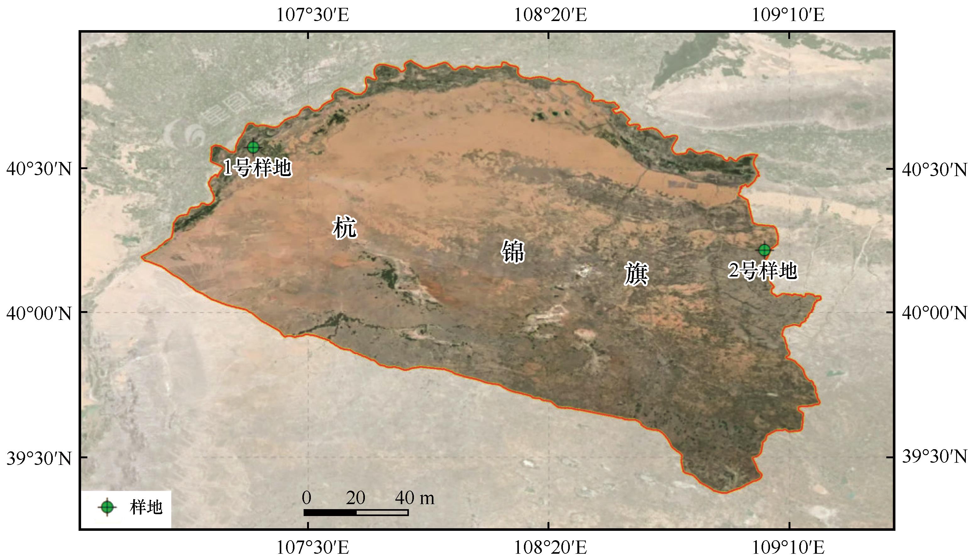
Fig.1 Spatial distribution of sampling sites
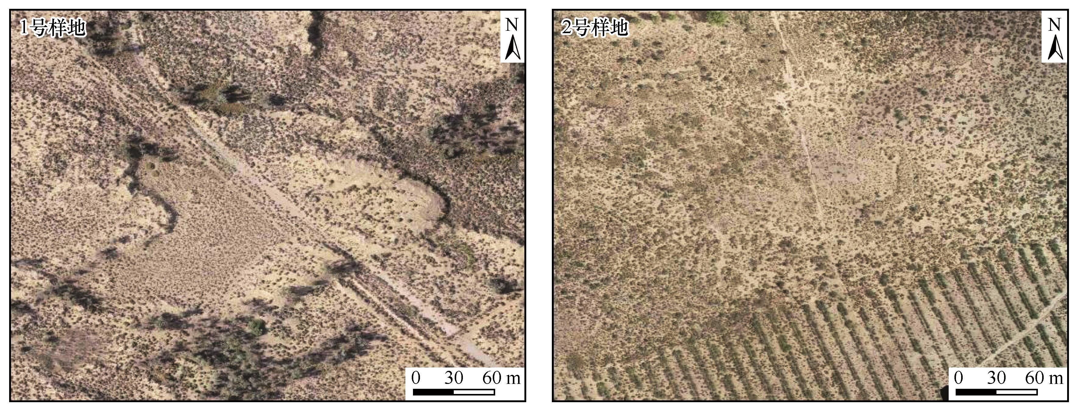
Fig.2 Orthophoto image of the unmanned aerial vehicle (UAV) plot
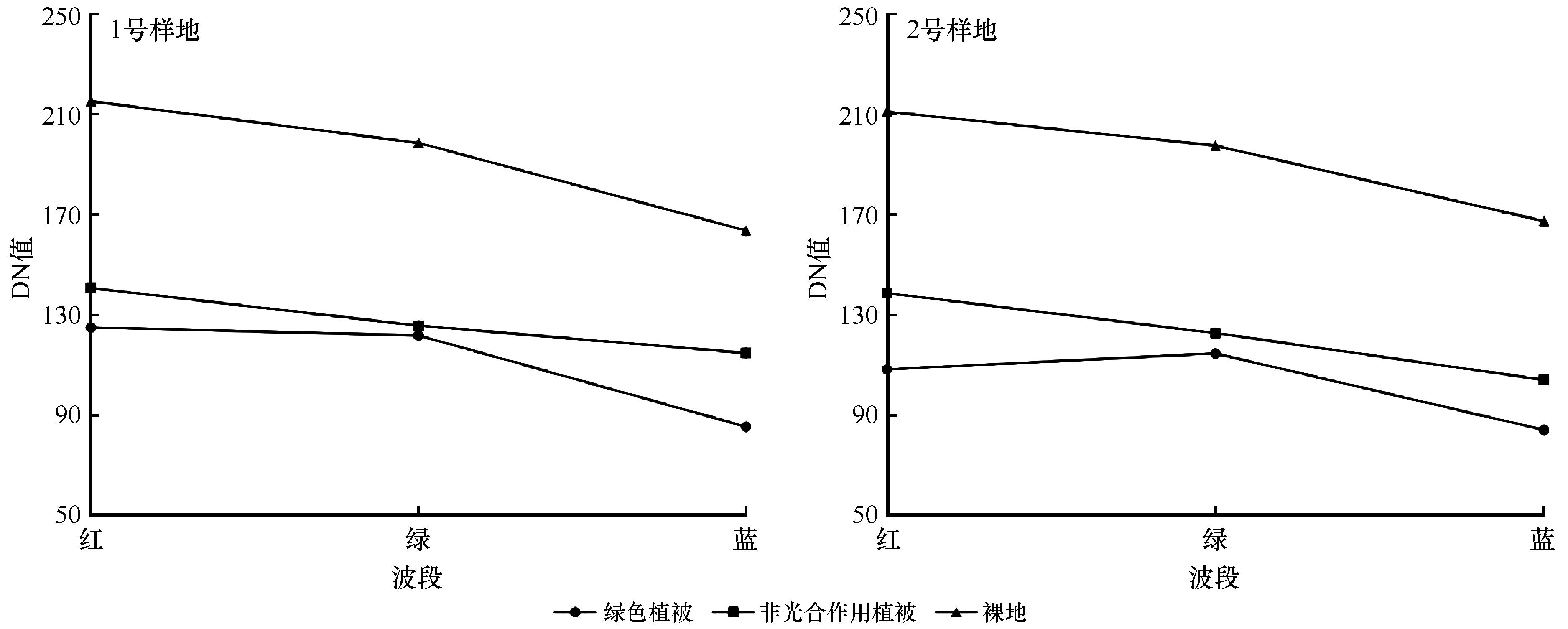
Fig.3 Spectral diagram of typical land features in the visible light band
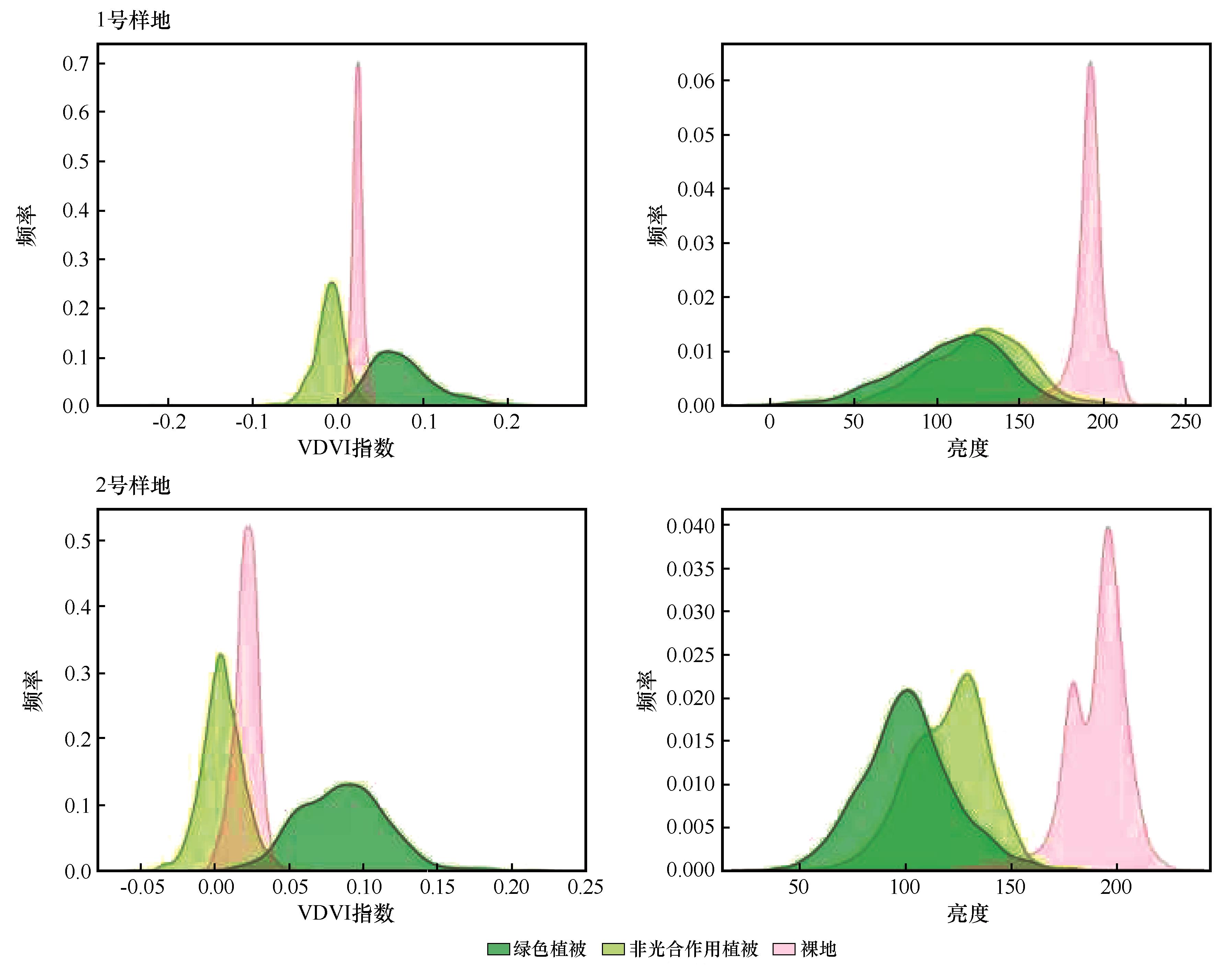
Fig.4 Distribution characteristics of VDVI and brightness values for typical features in two study plots
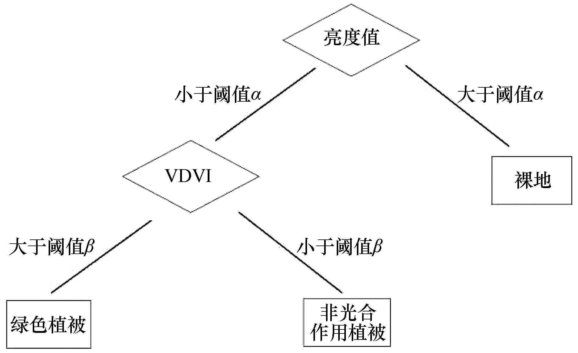
Fig.5 Semi-automatic threshold segmentation method
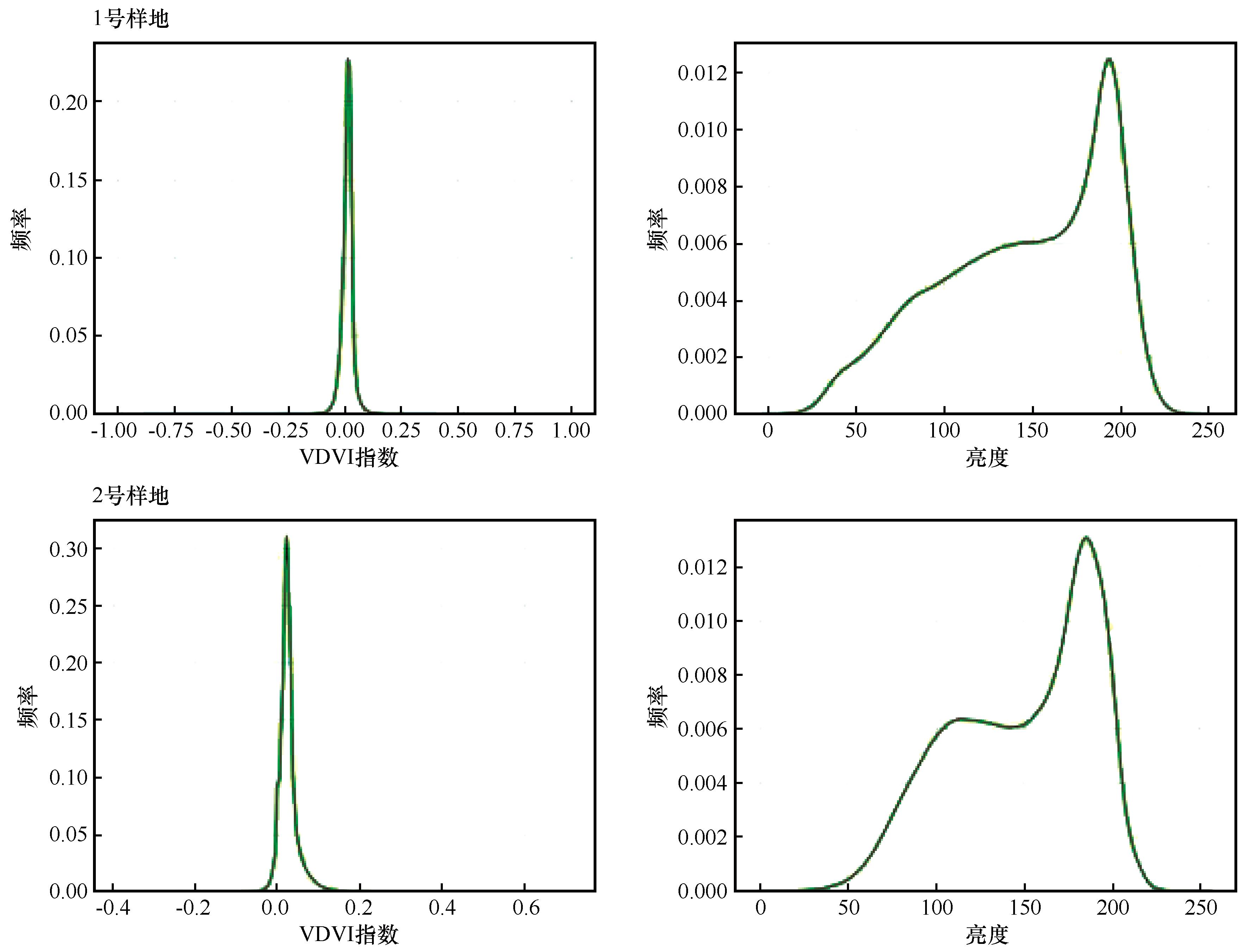
Fig.6 Histograms of VDVI index and brightness index for two plot areas
| 样地号 | 分类方法 | 地物占比/% | ||
|---|---|---|---|---|
| 绿色植被 | 非光合作用植被 | 裸地 | ||
| 1号样地 | 联合阈值法 | 11.31 | 38.15 | 50.53 |
| 随机森林法 | 8.46 | 46.49 | 45.05 | |
| 自动阈值法 | 20.46 | 17.91 | 61.63 | |
| 2号样地 | 联合阈值法 | 14.53 | 35.21 | 50.26 |
| 随机森林法 | 17.55 | 32.77 | 49.68 | |
| 自动阈值法 | 11.28 | 28.23 | 60.49 | |
Table 1 Statistical table of results from different classification method
| 样地号 | 分类方法 | 地物占比/% | ||
|---|---|---|---|---|
| 绿色植被 | 非光合作用植被 | 裸地 | ||
| 1号样地 | 联合阈值法 | 11.31 | 38.15 | 50.53 |
| 随机森林法 | 8.46 | 46.49 | 45.05 | |
| 自动阈值法 | 20.46 | 17.91 | 61.63 | |
| 2号样地 | 联合阈值法 | 14.53 | 35.21 | 50.26 |
| 随机森林法 | 17.55 | 32.77 | 49.68 | |
| 自动阈值法 | 11.28 | 28.23 | 60.49 | |
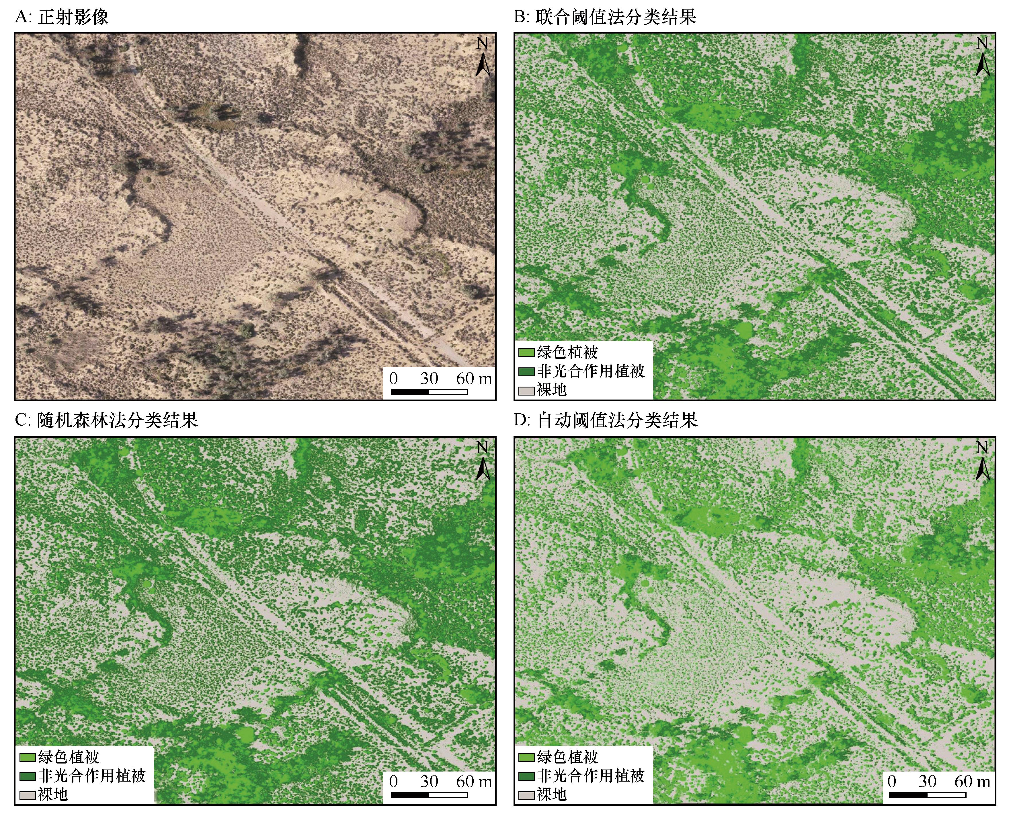
Fig.7 Classification results for Plot 1
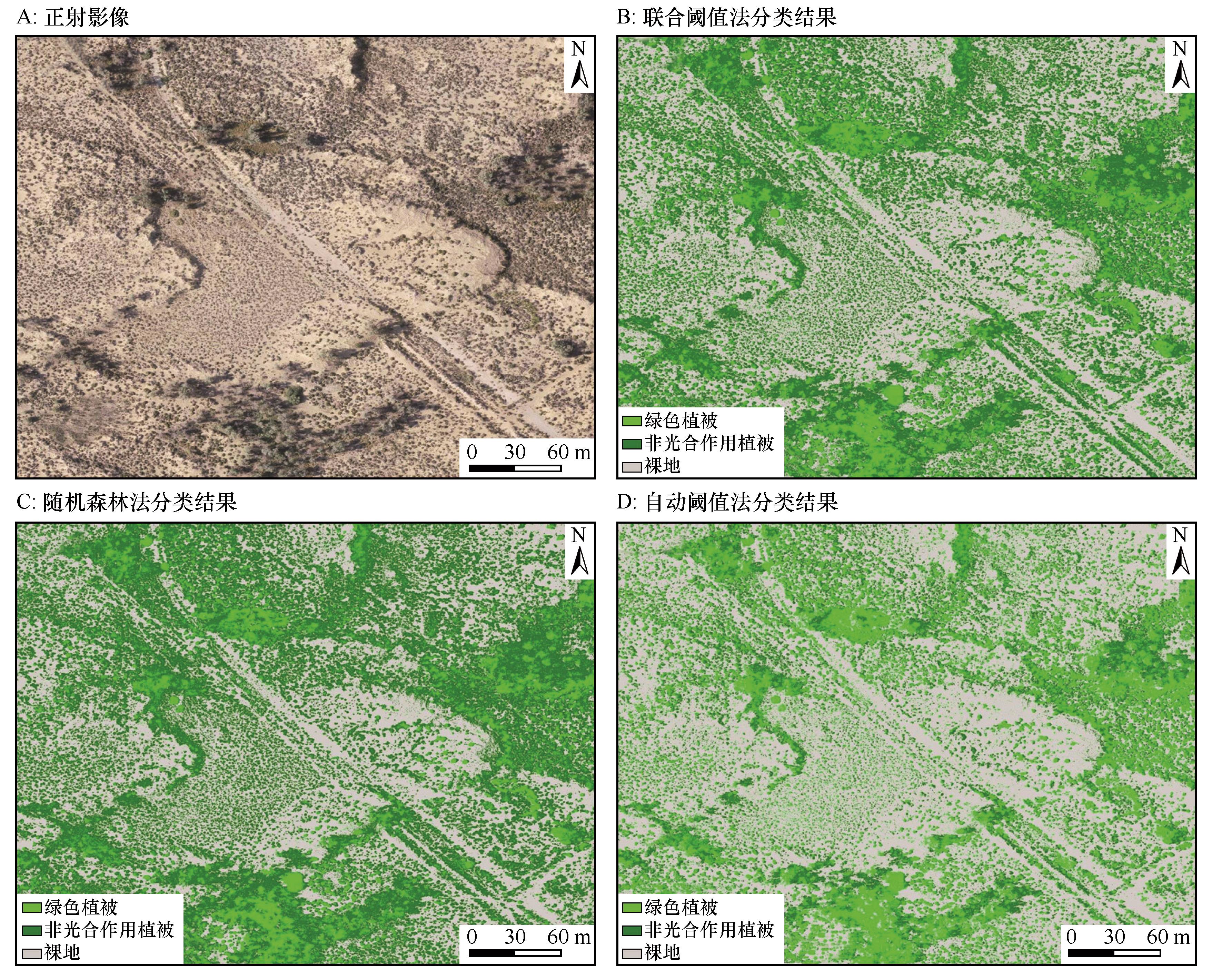
Fig.8 Classification results for Plot 2
| 样地 | 方法 | 总体精度 | kappa | 绿色植被 | 非光合作用植被 | 裸地 | ||||||
|---|---|---|---|---|---|---|---|---|---|---|---|---|
| 制图精度 | 用户精度 | f1-score | 制图精度 | 用户精度 | f1-score | 制图精度 | 用户精度 | f1-score | ||||
| 1号样地 | 联合阈值法 | 0.83 | 0.74 | 0.96 | 0.57 | 0.71 | 0.77 | 0.82 | 0.79 | 0.85 | 0.99 | 0.92 |
| 随机森林法 | 0.79 | 0.67 | 0.87 | 0.39 | 0.54 | 0.69 | 0.86 | 0.76 | 0.89 | 0.95 | 0.92 | |
| 自动阈值法 | 0.69 | 0.52 | 0.66 | 0.69 | 0.67 | 0.82 | 0.36 | 0.5 | 0.67 | 0.99 | 0.8 | |
| 2号样地 | 联合阈值法 | 0.91 | 0.85 | 0.83 | 0.83 | 0.83 | 0.92 | 0.83 | 0.87 | 0.92 | 1.00 | 0.96 |
| 随机森林法 | 0.85 | 0.76 | 0.85 | 0.81 | 0.83 | 0.86 | 0.75 | 0.80 | 0.85 | 0.95 | 0.90 | |
| 自动阈值法 | 0.81 | 0.68 | 0.95 | 0.65 | 0.77 | 0.86 | 0.66 | 0.75 | 0.75 | 0.98 | 0.85 | |
Table 2 Overall accuracy and category accuracy of the three methods
| 样地 | 方法 | 总体精度 | kappa | 绿色植被 | 非光合作用植被 | 裸地 | ||||||
|---|---|---|---|---|---|---|---|---|---|---|---|---|
| 制图精度 | 用户精度 | f1-score | 制图精度 | 用户精度 | f1-score | 制图精度 | 用户精度 | f1-score | ||||
| 1号样地 | 联合阈值法 | 0.83 | 0.74 | 0.96 | 0.57 | 0.71 | 0.77 | 0.82 | 0.79 | 0.85 | 0.99 | 0.92 |
| 随机森林法 | 0.79 | 0.67 | 0.87 | 0.39 | 0.54 | 0.69 | 0.86 | 0.76 | 0.89 | 0.95 | 0.92 | |
| 自动阈值法 | 0.69 | 0.52 | 0.66 | 0.69 | 0.67 | 0.82 | 0.36 | 0.5 | 0.67 | 0.99 | 0.8 | |
| 2号样地 | 联合阈值法 | 0.91 | 0.85 | 0.83 | 0.83 | 0.83 | 0.92 | 0.83 | 0.87 | 0.92 | 1.00 | 0.96 |
| 随机森林法 | 0.85 | 0.76 | 0.85 | 0.81 | 0.83 | 0.86 | 0.75 | 0.80 | 0.85 | 0.95 | 0.90 | |
| 自动阈值法 | 0.81 | 0.68 | 0.95 | 0.65 | 0.77 | 0.86 | 0.66 | 0.75 | 0.75 | 0.98 | 0.85 | |
| 样地 | 类别 | 联合阈值法(预测) | 自动阈值法(预测) | 合计 | ||||
|---|---|---|---|---|---|---|---|---|
| 绿色植被 | 非光合作用植被 | 裸地 | 绿色植被 | 非光合作用植被 | 裸地 | |||
1号样地 (真实) | 绿色植被 | 37 | 25 | 4 | 45 | 9 | 12 | 66 |
| 非光合作用植被 | 2 | 91 | 18 | 22 | 40 | 49 | 111 | |
| 裸地 | 0 | 1 | 122 | 1 | 0 | 122 | 123 | |
| 合计 | 39 | 117 | 144 | 68 | 49 | 183 | 300 | |
| 2号样地(真实) | 绿色植被 | 40 | 8 | 0 | 31 | 10 | 6 | 66 |
| 非光合作用植被 | 8 | 95 | 11 | 1 | 76 | 38 | 111 | |
| 裸地 | 0 | 0 | 138 | 1 | 2 | 135 | 123 | |
| 合计 | 48 | 103 | 149 | 33 | 88 | 179 | 300 | |
Table 3 Confusion matrix for combined index method and automatic thresholding
| 样地 | 类别 | 联合阈值法(预测) | 自动阈值法(预测) | 合计 | ||||
|---|---|---|---|---|---|---|---|---|
| 绿色植被 | 非光合作用植被 | 裸地 | 绿色植被 | 非光合作用植被 | 裸地 | |||
1号样地 (真实) | 绿色植被 | 37 | 25 | 4 | 45 | 9 | 12 | 66 |
| 非光合作用植被 | 2 | 91 | 18 | 22 | 40 | 49 | 111 | |
| 裸地 | 0 | 1 | 122 | 1 | 0 | 122 | 123 | |
| 合计 | 39 | 117 | 144 | 68 | 49 | 183 | 300 | |
| 2号样地(真实) | 绿色植被 | 40 | 8 | 0 | 31 | 10 | 6 | 66 |
| 非光合作用植被 | 8 | 95 | 11 | 1 | 76 | 38 | 111 | |
| 裸地 | 0 | 0 | 138 | 1 | 2 | 135 | 123 | |
| 合计 | 48 | 103 | 149 | 33 | 88 | 179 | 300 | |
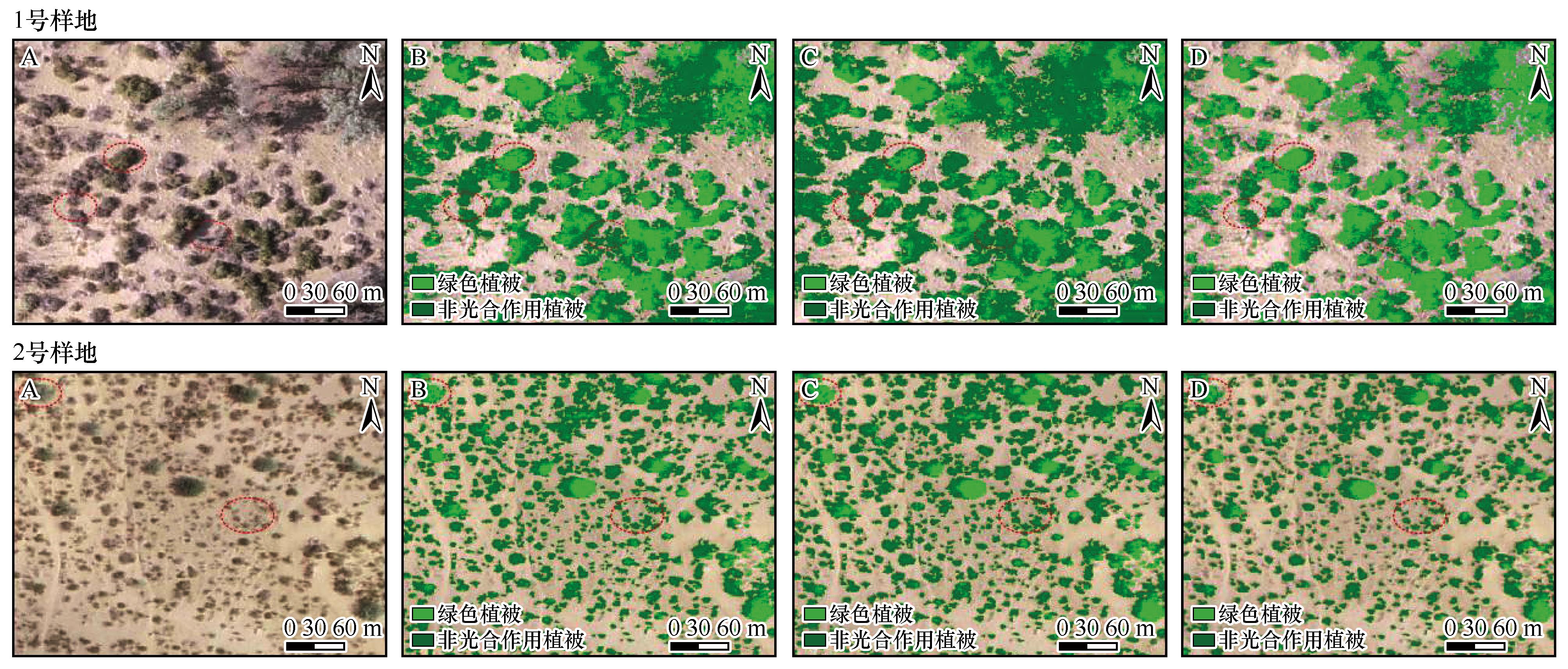
Fig.9 Partial enlargement of the classification results for plots
| 样地 | 类别 | 联合阈值法(预测) | 随机森林法(预测) | 合计 | ||||
|---|---|---|---|---|---|---|---|---|
| 绿色植被 | 非光合作用植被 | 裸地 | 绿色植被 | 非光合作用植被 | 裸地 | |||
1号样地 (真实) | 绿色植被 | 37 | 25 | 4 | 26 | 37 | 3 | 66 |
| 非光合作用植被 | 2 | 91 | 18 | 4 | 95 | 12 | 111 | |
| 裸地 | 0 | 1 | 122 | 0 | 6 | 117 | 123 | |
| 合计 | 39 | 117 | 144 | 30 | 138 | 132 | 300 | |
2号样地 (真实) | 绿色植被 | 40 | 8 | 0 | 39 | 8 | 1 | 66 |
| 非光合作用植被 | 8 | 95 | 11 | 6 | 86 | 22 | 111 | |
| 裸地 | 0 | 0 | 138 | 1 | 6 | 131 | 123 | |
| 合计 | 48 | 103 | 149 | 46 | 100 | 154 | 300 | |
Table 4 Confusion matrix for the combined index method and random forest
| 样地 | 类别 | 联合阈值法(预测) | 随机森林法(预测) | 合计 | ||||
|---|---|---|---|---|---|---|---|---|
| 绿色植被 | 非光合作用植被 | 裸地 | 绿色植被 | 非光合作用植被 | 裸地 | |||
1号样地 (真实) | 绿色植被 | 37 | 25 | 4 | 26 | 37 | 3 | 66 |
| 非光合作用植被 | 2 | 91 | 18 | 4 | 95 | 12 | 111 | |
| 裸地 | 0 | 1 | 122 | 0 | 6 | 117 | 123 | |
| 合计 | 39 | 117 | 144 | 30 | 138 | 132 | 300 | |
2号样地 (真实) | 绿色植被 | 40 | 8 | 0 | 39 | 8 | 1 | 66 |
| 非光合作用植被 | 8 | 95 | 11 | 6 | 86 | 22 | 111 | |
| 裸地 | 0 | 0 | 138 | 1 | 6 | 131 | 123 | |
| 合计 | 48 | 103 | 149 | 46 | 100 | 154 | 300 | |
| [1] | 高永平,康茂东,何明珠,等.基于无人机可见光波段对荒漠植被覆盖度提取的研究[J].兰州大学学报(自然科学版),2018,54(6):770-775. |
| [2] | 韩婕,曹晓明.荒漠植被覆盖度遥感提取研究进展[J].环境科学研究,2024,37(10):2288-2298. |
| [3] | 王珍,郭小平,魏秀丽.基于可见光影像提取干旱荒漠区植被覆盖度[J].中国水土保持科学(中英文),2025,23(4):129-141. |
| [4] | 唐亮,何明珠,许华,等.基于无人机低空遥感的荒漠植被覆盖度与归一化植被指数验证及其对水热梯度的响应[J].应用生态学报,2020,31(1):35-44. |
| [5] | 付镇,张志敏,张变第,等.宁夏农牧交错区植被覆盖时空变化及成因分析[J].西北林学院学报,2023,38(2):209-216. |
| [6] | 杨红艳,杜健民,阮培英,等.基于无人机遥感与随机森林的荒漠草原植被分类方法[J].农业机械学报,2021,52(6):186-194. |
| [7] | Bai X, Zhao W, Ji S,et al.Estimating fractional cover of non-photosynthetic vegetation for various grasslands based on CAI and DFI[J].Ecological Indicators,2021,131:108252. |
| [8] | Chai G, Wang J, Wu M,et al.Mapping the fractional cover of non-photosynthetic vegetation and its spatiotemporal variations in the Xilingol grassland using MODIS imagery (2000-2019)[J].Geocarto International,2022,37(7):1863-1879. |
| [9] | Tian J, Su S, Tian Q,et al.A novel spectral index for estimating fractional cover of non-photosynthetic vegetation using near-infrared bands of Sentinel satellite[J].International Journal of Applied Earth Observation and Geoinformation,2021,101:102361. |
| [10] | 袁浩,姬翠翠,杨雪梅,等.结合Sentinel-2数据与光谱特征的稀疏非光合植被指数构建[J].地球信息科学学报,2023,25(9):1894-1907. |
| [11] | Ji C, Li X, Wei H,et al.Comparison of different multispectral sensors for photosynthetic and non-photosynthetic vegetation-fraction retrieval[J].Remote Sensing,2020,12(1):115. |
| [12] | Fan C, Chen G, Zhong R,et al.Estimation of non-photosynthetic vegetation cover using the NDVI-DFI model in a typical dry-hot valley,Southwest China[J].ISPRS International Journal of Geo-Information,2024,13(12):440. |
| [13] | Han X, Zhao C, Ji M,et al.Identification of non-photosynthetic vegetation fractional cover via spectral data constrained unmixing algorithm optimization[J].Remote Sensing,2025,17(20):3480. |
| [14] | 姬翠翠,骆义峡,李晓松,等.Sentinel-1和Sentinel-2良好反演稀疏非光合植被覆盖度[J].遥感学报,2023,27(12):2873-2881. |
| [15] | 韦钦桦,罗文斐,唐凯丰.考虑植被端元变异性的光谱解混方法[J].遥感学报,2023,27(2):456-470. |
| [16] | He J, Lyu D, He L,et al.Combining object-oriented and deep learning methods to estimate photosynthetic and non-photosynthetic vegetation cover in the desert from unmanned aerial vehicle images with consideration of shadows[J].Remote Sensing,2022,15(1):105. |
| [17] | 张凡,仇天昊,李欣悦,等.基于改进像元三分模型的植被覆盖度提取及时空变化分析[J].林业科学,2024,60(12):13-26. |
| [18] | He J, Zhang X, Li W,et al.Extraction of photosynthetic and non-photosynthetic vegetation cover in typical grasslands using UAV imagery and an improved SegFormer Model[J].Remote Sensing,2025,17(18):3162. |
| [19] | 郝梦宇,秦龙君,毛鹏,等.基于无人机可见光影像的荒漠植被分布格局研究方法[J].中国沙漠,2020,40(6):169-179. |
| [20] | 花蕊,周睿,王婷,等.基于无人机遥感的高寒草原沙化模型及等级划分[J].中国沙漠,2019,39(1):26-33. |
| [21] | 张和钰,管文轲,李志鹏,等.基于无人机影像的戈壁区植被空间分布特征及其主要影响因素研究[J].干旱区资源与环境,2020,34(2):161-167. |
| [22] | 周涛,胡振琪,韩佳政,等.基于无人机可见光影像的绿色植被提取[J].中国环境科学,2021,41(5):2380-2390. |
| [23] | 汪小钦,王苗苗,王绍强,等.基于可见光波段无人机遥感的植被信息提取[J].农业工程学报 2015,31(5):152-159. |
| [24] | Wang S, Baum A, Zarco-Tejada P J,et al.Unmanned Aerial System multispectral mapping for low and variable solar irradiance conditions:potential of tensor decomposition[J].ISPRS Journal of Photogrammetry and Remote Sensing,2019,155:58-71. |
| [25] | 王美琪,杨建英,孙永康,等.废弃矿山植被覆盖度无人机遥感快速提取技术[J].中国水土保持科学(中英文),2020,18(02):130-139. |
| [26] | 刘琳,郑兴明,姜涛,等.无人机遥感植被覆盖度提取方法研究综述[J].东北师大学报(自然科学版),2021,53(4):151-160. |
| [27] | 崔万新,李锦荣,司前程,等.基于无人机可见光数据荒漠灌木覆盖度提取方法研究[J].水土保持研究,2021,28(6):175-183. |
| [28] | 岳健,穆桂金,唐自华,等.基于NDVI的新疆荒漠地区植被覆盖度遥感估算经验模型研究[J].干旱区地理,2020,43(1):153-160. |
| [29] | 张亦然,刘廷玺,童新,等.基于U型神经网络的沙丘-草甸相间地区无人机影像植被覆盖度提取及其影响因素[J].中国沙漠,2021,41(3):16-24. |
| [30] | 芦瑞杰,刘树林,康文平,等.结合GEE平台与机器学习算法的荒漠信息提取[J].中国沙漠,2023,43(6):60-70. |
| [31] | 张浪,党国锋,鱼腾飞,等.基于无人机激光雷达的额济纳绿洲植被覆盖度监测及变化分析[J].中国沙漠,2024,44(5):170-181. |
| [32] | 张亦然,刘廷玺,童新 等.基于多源遥感和机器学习方法的科尔沁沙地植被覆盖度反演[J].中国沙漠,2022,42(03):187-195. |
| [33] | 韦钦桦,罗文斐,李浩,等.基于无人机高光谱影像的植被覆盖度遥感估算模型比较[J].华南师范大学学报(自然科学版),2021,53(6):79-87. |
| [34] | 加力戈,张勃,魏怀东.三种典型荒漠植物生长期光谱特征变化分析[J].光谱学与光谱分析,2018,38(9):2881-2887. |
| [35] | Liu J, Fan J, Yang C,et al.Novel vegetation indices for estimating photosynthetic and non-photosynthetic fractional vegetation cover from Sentinel data[J].International Journal of Applied Earth Observation and Geoinformation,2022,109:102793. |
| [36] | 王光镇,王静璞,邹学勇,等.遥感技术指导非光合植被覆盖度研究综述[J].遥感技术与应用,2018,33(1):1-9. |
| [37] | 柴国奇,王静璞,邹学勇,等.基于Sentinel-2数据的典型草原光合/非光合植被覆盖度指示[J].草业科学,2018,35(12):2836-2844. |
| [38] | Zi-chen G, Tao W, Shu-lin L,et al.Comparison of the backpropagation network and the random forest algorithm based on sampling distribution effects consideration for estimating nonphotosynthetic vegetation Cover[J].International Journal of Applied Earth Observation and Geoinformation,2021,104:102573. |
| [39] | Shumack S, Fisher A, Hesse P P.Refining medium resolution fractional cover for arid Australia to detect vegetation dynamics and wind erosion susceptibility on longitudinal Dunes[J].Remote Sensing of Environment,2021,265:112647. |
| [40] | 崔琰.库布齐沙漠土地荒漠化动态变化与旅游开发研究[D].北京:中国科学院研究生院,2010. |
| [41] | Tin Kam Ho.The random subspace method for constructing decision forests[J].IEEE Transactions on Pattern Analysis and Machine Intelligence,1998,20(8):832-844. |
| [42] | Otsu N.A threshold selection method from gray-level histograms[J].IEEE Transactions on Systems,Man,and Cybernetics,1979,9(1):62-66. |
| [43] | 伏帅,张勇辉,李佳吕,等.不同植被指数和无人机航高对草地盖度估测精度的影响[J].草业科学,2021,38(1):11-19. |
| [44] | Woodcock C E, Strahler A H, Jupp D L B.The use of variograms in remote sensing:I.scene models and simulated Images[J].Remote Sensing of Environment,1988,25(3):323-348. |
| [45] | 骆秀齐,郝庆雨.建筑区遥感观测最优尺度确定方法优化研究[J].北京测绘,2019,33(3):274-279. |
| [46] | 温兆飞,张树清,白静,等.农田景观空间异质性分析及遥感监测最优尺度选择:以三江平原为例[J].地理学报,2012,67(3):346-356. |
| [47] | Huang Q, Gao W, Cai W.Thresholding technique with adaptive window selection for uneven lighting image[J].Pattern Recognition Letters,2005,26(6):801-808. |
| [48] | Pattnaik T, Kanungo P.Adaptive window selection for non-uniform lighting image thresholding[J].Electronic Letters on Computer Vision and Image Analysis,2021,20(1):42-54. |
| [49] | Yan G, Li L, Coyc A,et al.Improving the estimation of fractional vegetation cover from UAV RGB imagery by colour unmixing[J].ISPRS Journal of Photogrammetry and Remote Sensing,2019,158:23-34. |
| [50] | Kirillov A, Mintun E, Ravi N,et al.Segment Anything[Z].arXiv,2023. |
| [1] | Mengyu Hao, Longjun Qin, Peng Mao, Jiechunyi Luo, Wenli Zhao, Guoyu Qiu. Unmanned aerial vehicle (UAV) based methodology for spatial distribution pattern analysis of desert vegetation [J]. Journal of Desert Research, 2020, 40(6): 169-179. |
| [2] | Pan Kaijia, Zhang Zhengcai, Liang Aimin, Dong Zhibao, Li Xingcai. Nebkhas geomorphology in the gobi desert using the unmanned aerial vehicle and tilt camera [J]. Journal of Desert Research, 2020, 40(2): 24-32. |
| Viewed | ||||||
|
Full text |
|
|||||
|
Abstract |
|
|||||
©2018Journal of Desert Research
Tel:0931-8267545
Email:caiedit@lzb.ac.cn;desert@lzb.ac.cn
Support:Magtech
