
- CN 62-1070/P
- ISSN 1000-694X
- Bimonthly 1981
Journal of Desert Research ›› 2023, Vol. 43 ›› Issue (3): 107-118.DOI: 10.7522/j.issn.1000-694X.2022.00148
Yating Cui1( ), Huan Li1,2(), Longxiao Zheng1, Mengquan Wu1
Received:2022-09-30
Revised:2022-11-20
Online:2023-05-20
Published:2023-05-31
Contact:
Huan Li
CLC Number:
Yating Cui, Huan Li, Longxiao Zheng, Mengquan Wu. Study of ecological environmental quality changes in the upper Yellow River basin based on remote sensing ecological index[J]. Journal of Desert Research, 2023, 43(3): 107-118.
Add to citation manager EndNote|Ris|BibTeX
URL: http://www.desert.ac.cn/EN/10.7522/j.issn.1000-694X.2022.00148
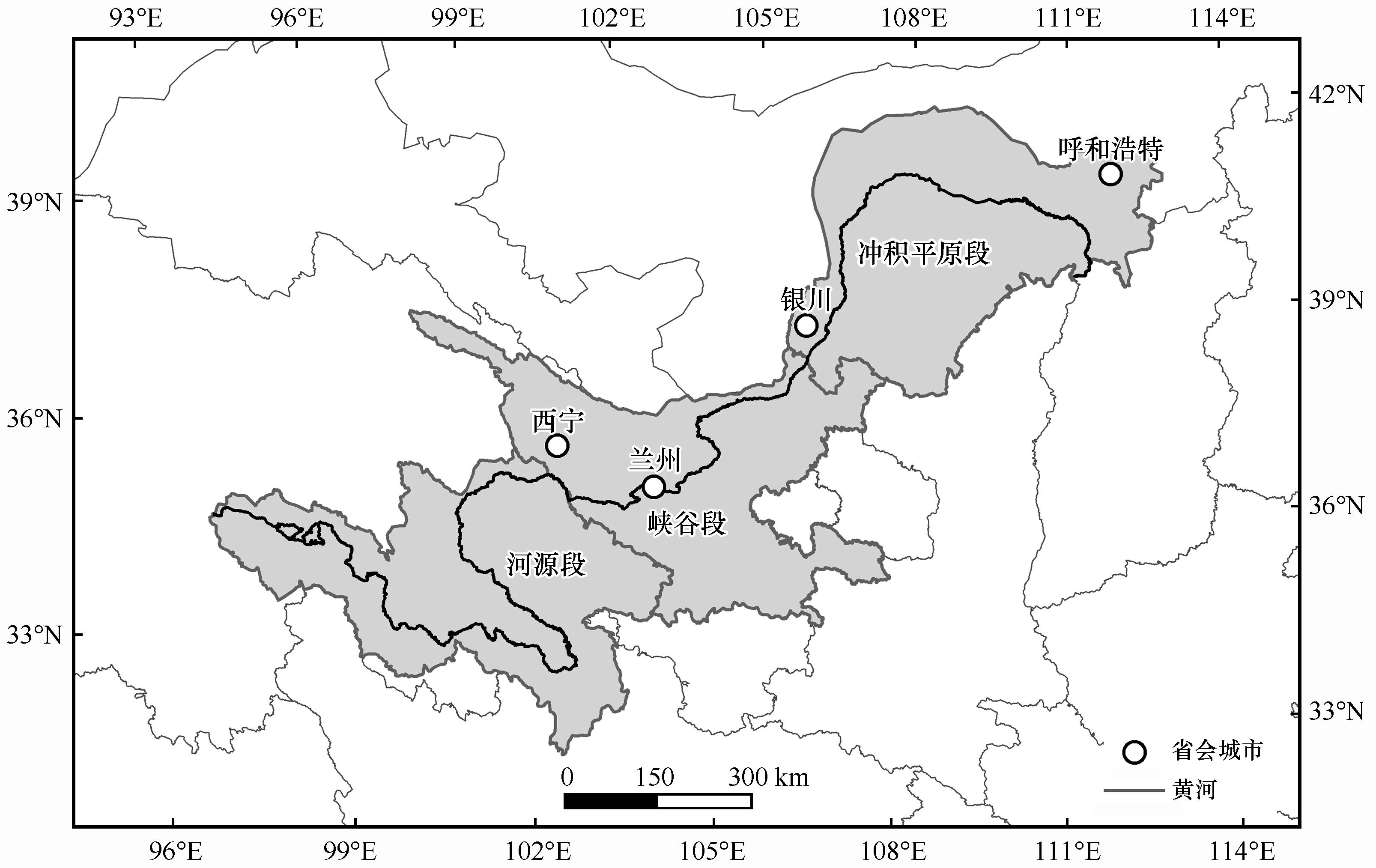
Fig.1 Location of the upper Yellow River basin
| 指标 | 计算方法 |
|---|---|
| NDVI | |
| WET | |
| NDBSI | |
| LST |
Table 1 Calculation methods of indicators
| 指标 | 计算方法 |
|---|---|
| NDVI | |
| WET | |
| NDBSI | |
| LST |
| 年份 | 指标 | PC1 | PC2 | PC3 | PC4 |
|---|---|---|---|---|---|
| 2000 | WET | 0.109 | 0.142 | 0.318 | 0.930 |
| NDVI | 0.670 | 0.670 | 0.292 | 0.124 | |
| NDBSI | -0.437 | -0.011 | -0.833 | -0.338 | |
| LST | -0.589 | -0.727 | -0.345 | -0.062 | |
| 特征值 | 0.045 | 0.009 | 0.003 | 0.001 | |
| 贡献率/% | 78.07 | 16.27 | 5.49 | 0.17 | |
| 2007 | WET | 0.117 | 0.115 | 0.341 | 0.925 |
| NDVI | 0.651 | 0.616 | 0.416 | 0.148 | |
| NDBSI | -0.501 | -0.086 | -0.789 | -0.344 | |
| LST | -0.557 | -0.773 | -0.294 | -0.059 | |
| 特征值 | 0.042 | 0.008 | 0.004 | 0.001 | |
| 贡献率/% | 76.31 | 15.77 | 7.70 | 0.22 | |
| 2014 | WET | 0.152 | 0.335 | 0.316 | 0.874 |
| NDVI | 0.687 | 0.708 | 0.019 | 0.158 | |
| NDBSI | -0.466 | -0.332 | -0.681 | -0.455 | |
| LST | -0.535 | -0.524 | -0.659 | -0.055 | |
| 特征值 | 0.046 | 0.015 | 0.005 | 0.002 | |
| 贡献率/% | 79.11 | 13.15 | 7.43 | 0.30 | |
| 2021 | WET | 0.146 | 0.229 | 0.359 | 0.892 |
| NDVI | 0.690 | 0.646 | 0.280 | 0.165 | |
| NDBSI | -0.504 | -0.106 | -0.751 | -0.412 | |
| LST | -0.498 | -0.720 | -0.477 | -0.074 | |
| 特征值 | 0.062 | 0.012 | 0.005 | 0.002 | |
| 贡献率/% | 77.81 | 15.43 | 6.54 | 0.22 |
Table 2 Results of principal component analysis
| 年份 | 指标 | PC1 | PC2 | PC3 | PC4 |
|---|---|---|---|---|---|
| 2000 | WET | 0.109 | 0.142 | 0.318 | 0.930 |
| NDVI | 0.670 | 0.670 | 0.292 | 0.124 | |
| NDBSI | -0.437 | -0.011 | -0.833 | -0.338 | |
| LST | -0.589 | -0.727 | -0.345 | -0.062 | |
| 特征值 | 0.045 | 0.009 | 0.003 | 0.001 | |
| 贡献率/% | 78.07 | 16.27 | 5.49 | 0.17 | |
| 2007 | WET | 0.117 | 0.115 | 0.341 | 0.925 |
| NDVI | 0.651 | 0.616 | 0.416 | 0.148 | |
| NDBSI | -0.501 | -0.086 | -0.789 | -0.344 | |
| LST | -0.557 | -0.773 | -0.294 | -0.059 | |
| 特征值 | 0.042 | 0.008 | 0.004 | 0.001 | |
| 贡献率/% | 76.31 | 15.77 | 7.70 | 0.22 | |
| 2014 | WET | 0.152 | 0.335 | 0.316 | 0.874 |
| NDVI | 0.687 | 0.708 | 0.019 | 0.158 | |
| NDBSI | -0.466 | -0.332 | -0.681 | -0.455 | |
| LST | -0.535 | -0.524 | -0.659 | -0.055 | |
| 特征值 | 0.046 | 0.015 | 0.005 | 0.002 | |
| 贡献率/% | 79.11 | 13.15 | 7.43 | 0.30 | |
| 2021 | WET | 0.146 | 0.229 | 0.359 | 0.892 |
| NDVI | 0.690 | 0.646 | 0.280 | 0.165 | |
| NDBSI | -0.504 | -0.106 | -0.751 | -0.412 | |
| LST | -0.498 | -0.720 | -0.477 | -0.074 | |
| 特征值 | 0.062 | 0.012 | 0.005 | 0.002 | |
| 贡献率/% | 77.81 | 15.43 | 6.54 | 0.22 |
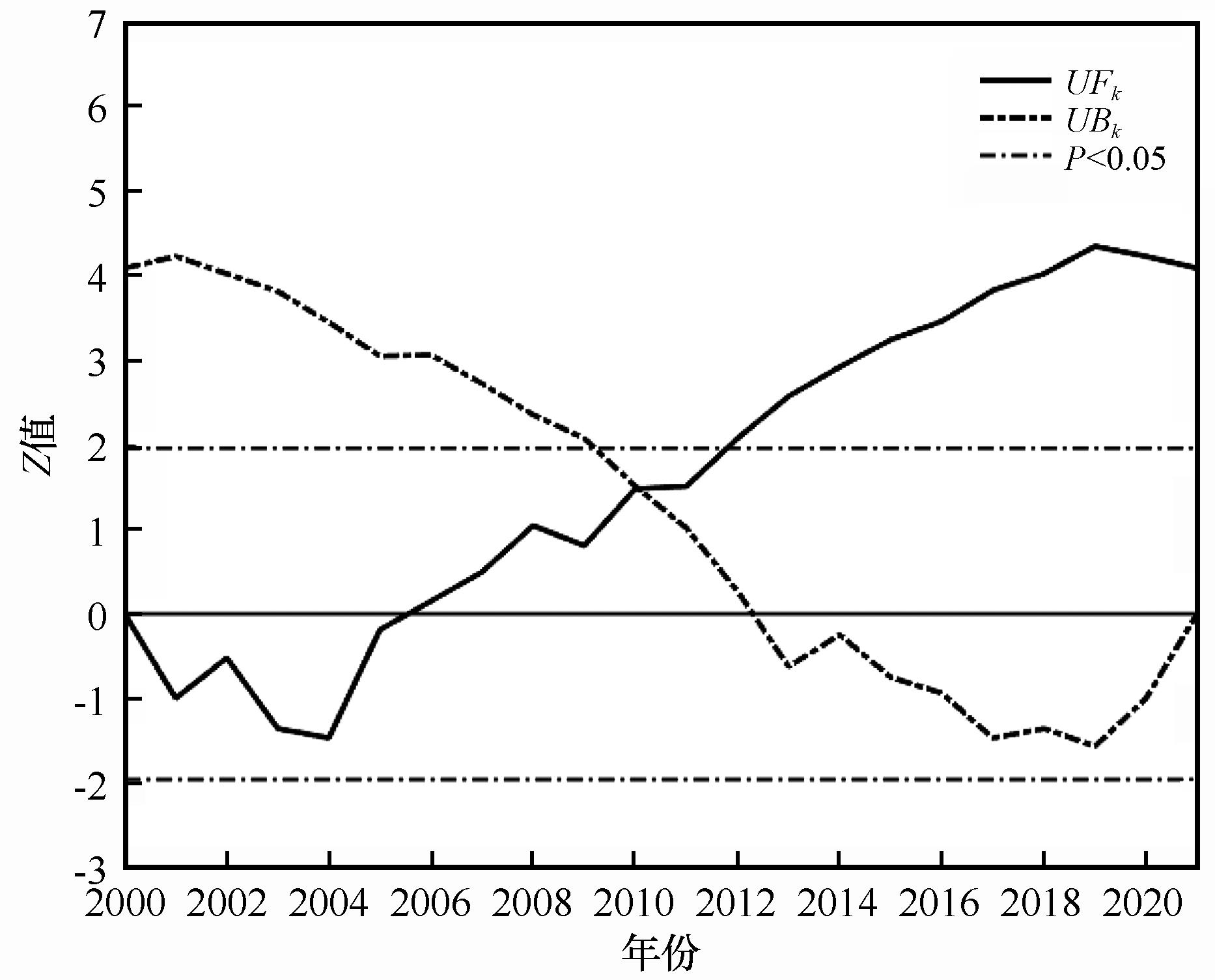
Fig.2 Analysis of RSEI changes in the upper Yellow River basin based on Mann-Kendall test
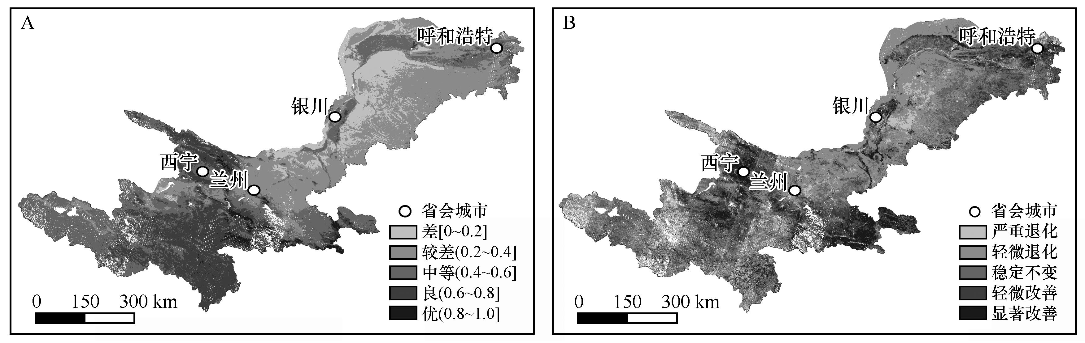
Fig. 3 Spatial distribution and change of ecological environmental quality in the upper Yellow River basin from 2000 to 2021
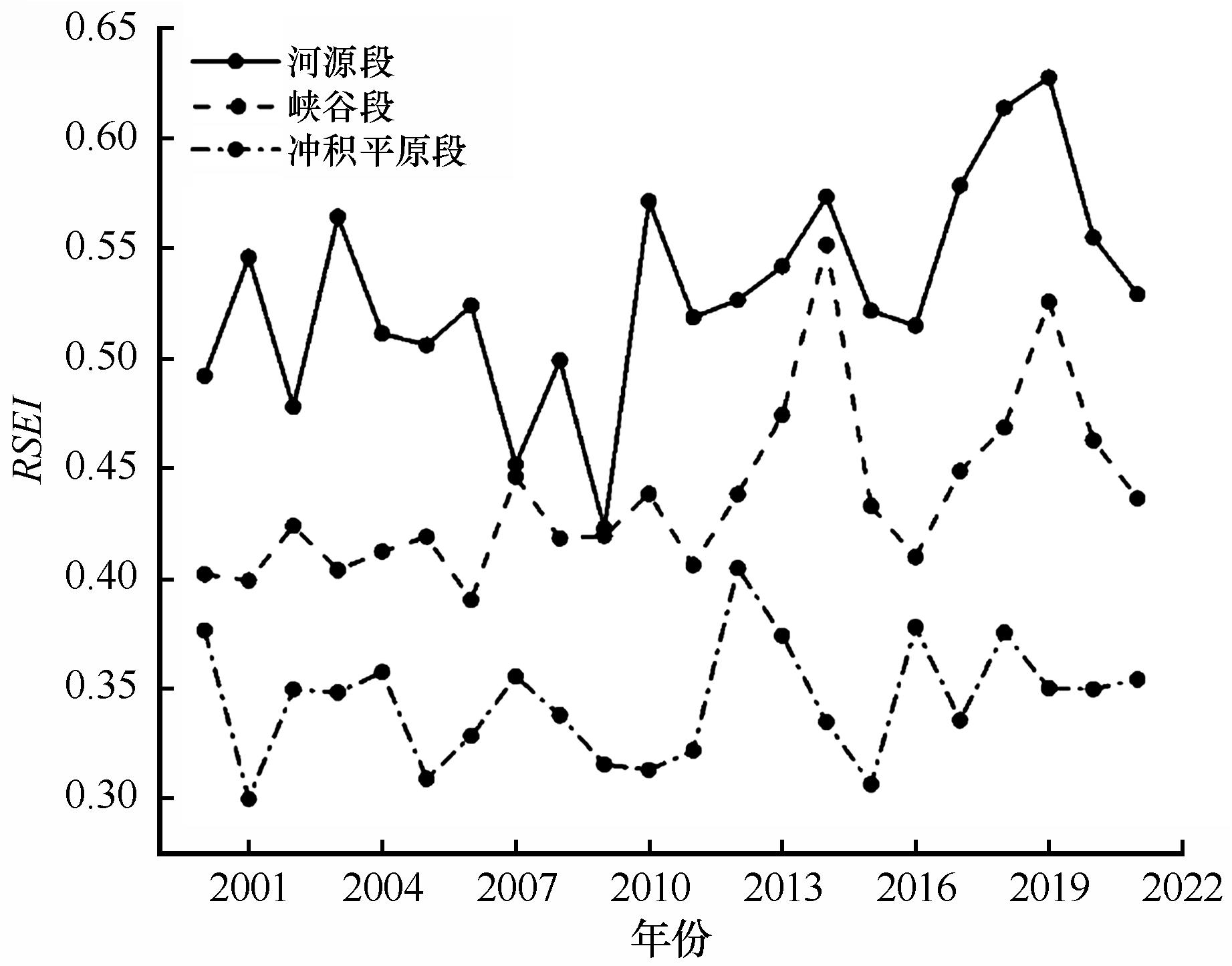
Fig. 4 Ecological environmental quality of different river sections in the upper Yellow River basin from 2000 to 2021
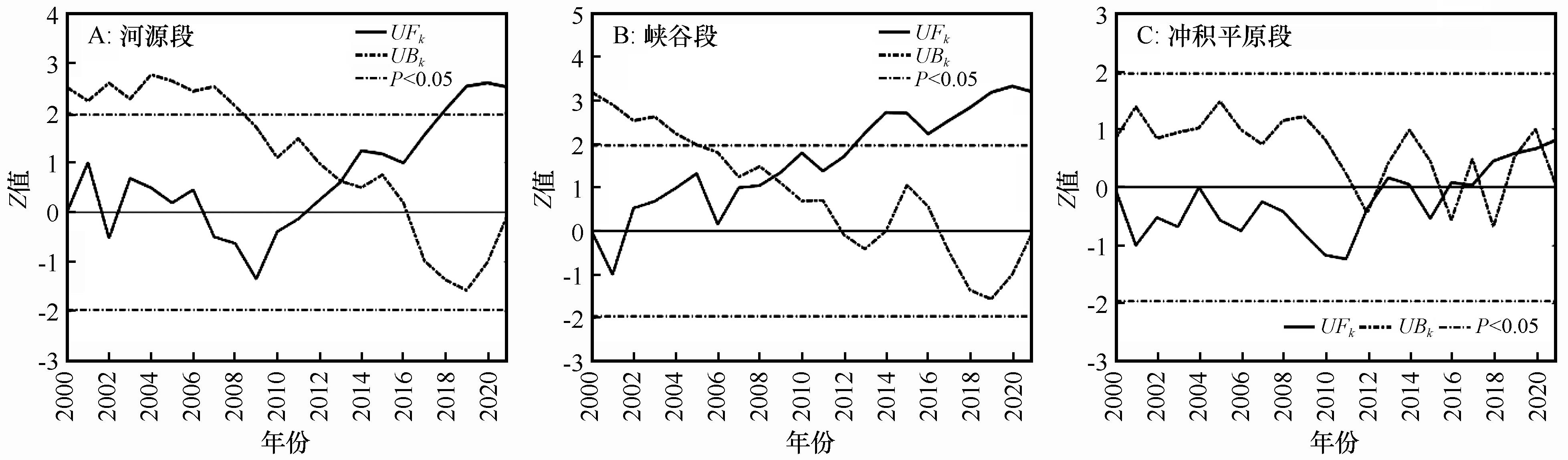
Fig. 5 Analysis of RSEI changes in the river source section (A), canyon section (B) and alluvial plain section (C) of the upper Yellow River basin based on the Mann-Kendall test
| 年份 | 全局Moran' I指数 | 方差 | Z值 | P值 |
|---|---|---|---|---|
| 2000 | 0.481 | 0.000034 | 82.62 | 0.0000 |
| 2007 | 0.486 | 0.000038 | 78.94 | 0.0000 |
| 2014 | 0.515 | 0.000041 | 80.11 | 0.0000 |
| 2021 | 0.581 | 0.000038 | 94.63 | 0.0000 |
Table 3 Global spatial autocorrelation analysis of the upper Yellow River basin from 2000 to 2021
| 年份 | 全局Moran' I指数 | 方差 | Z值 | P值 |
|---|---|---|---|---|
| 2000 | 0.481 | 0.000034 | 82.62 | 0.0000 |
| 2007 | 0.486 | 0.000038 | 78.94 | 0.0000 |
| 2014 | 0.515 | 0.000041 | 80.11 | 0.0000 |
| 2021 | 0.581 | 0.000038 | 94.63 | 0.0000 |
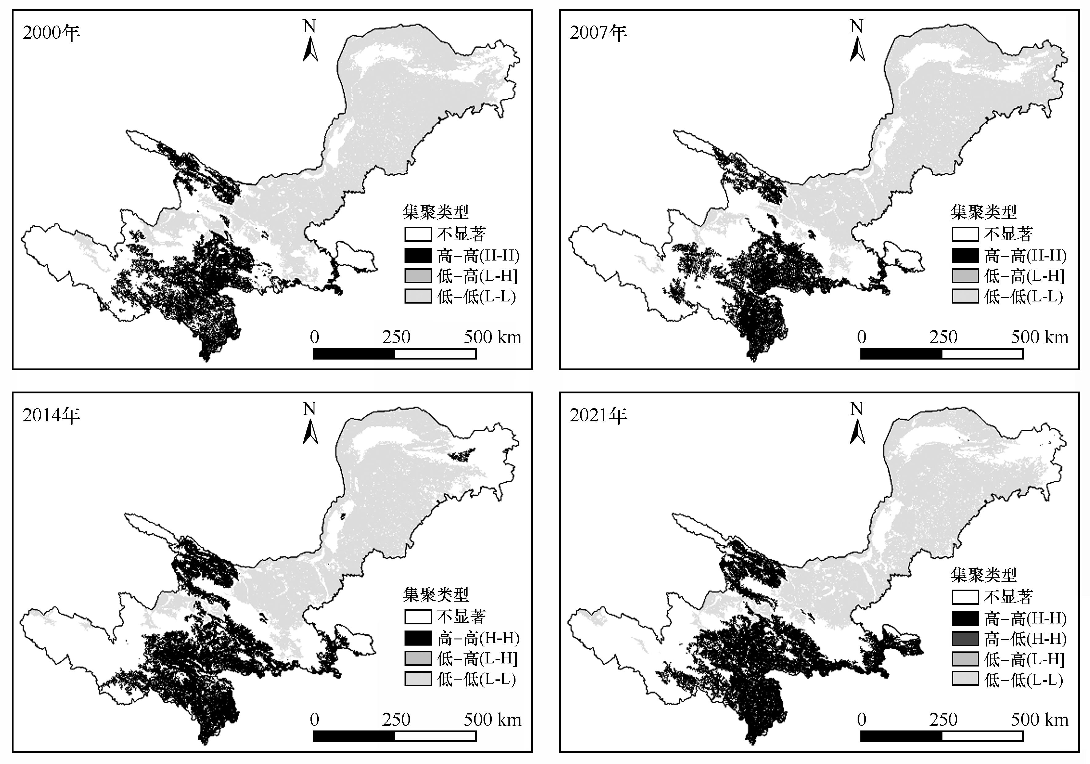
Fig. 6 Local spatial autocorrelation analysis of the upper Yellow River basin from 2000 to 2021
| 影响因子 | 2000年 | 2007年 | 2014年 | 2021年 | q平均值 | ||||
|---|---|---|---|---|---|---|---|---|---|
| q值 | P值 | q值 | P值 | q值 | P值 | q值 | P值 | ||
| NDVI | 0.825 | 0.000 | 0.817 | 0.000 | 0.822 | 0.000 | 0.830 | 0.000 | 0.823 |
| WET | 0.688 | 0.000 | 0.623 | 0.000 | 0.604 | 0.000 | 0.658 | 0.000 | 0.643 |
| LST | 0.725 | 0.000 | 0.768 | 0.000 | 0.725 | 0.000 | 0.707 | 0.000 | 0.731 |
| NDBSI | 0.801 | 0.000 | 0.791 | 0.000 | 0.798 | 0.000 | 0.807 | 0.000 | 0.799 |
Table 4 Detection results of ecological environmental quality impact factors in the upper Yellow River basin
| 影响因子 | 2000年 | 2007年 | 2014年 | 2021年 | q平均值 | ||||
|---|---|---|---|---|---|---|---|---|---|
| q值 | P值 | q值 | P值 | q值 | P值 | q值 | P值 | ||
| NDVI | 0.825 | 0.000 | 0.817 | 0.000 | 0.822 | 0.000 | 0.830 | 0.000 | 0.823 |
| WET | 0.688 | 0.000 | 0.623 | 0.000 | 0.604 | 0.000 | 0.658 | 0.000 | 0.643 |
| LST | 0.725 | 0.000 | 0.768 | 0.000 | 0.725 | 0.000 | 0.707 | 0.000 | 0.731 |
| NDBSI | 0.801 | 0.000 | 0.791 | 0.000 | 0.798 | 0.000 | 0.807 | 0.000 | 0.799 |
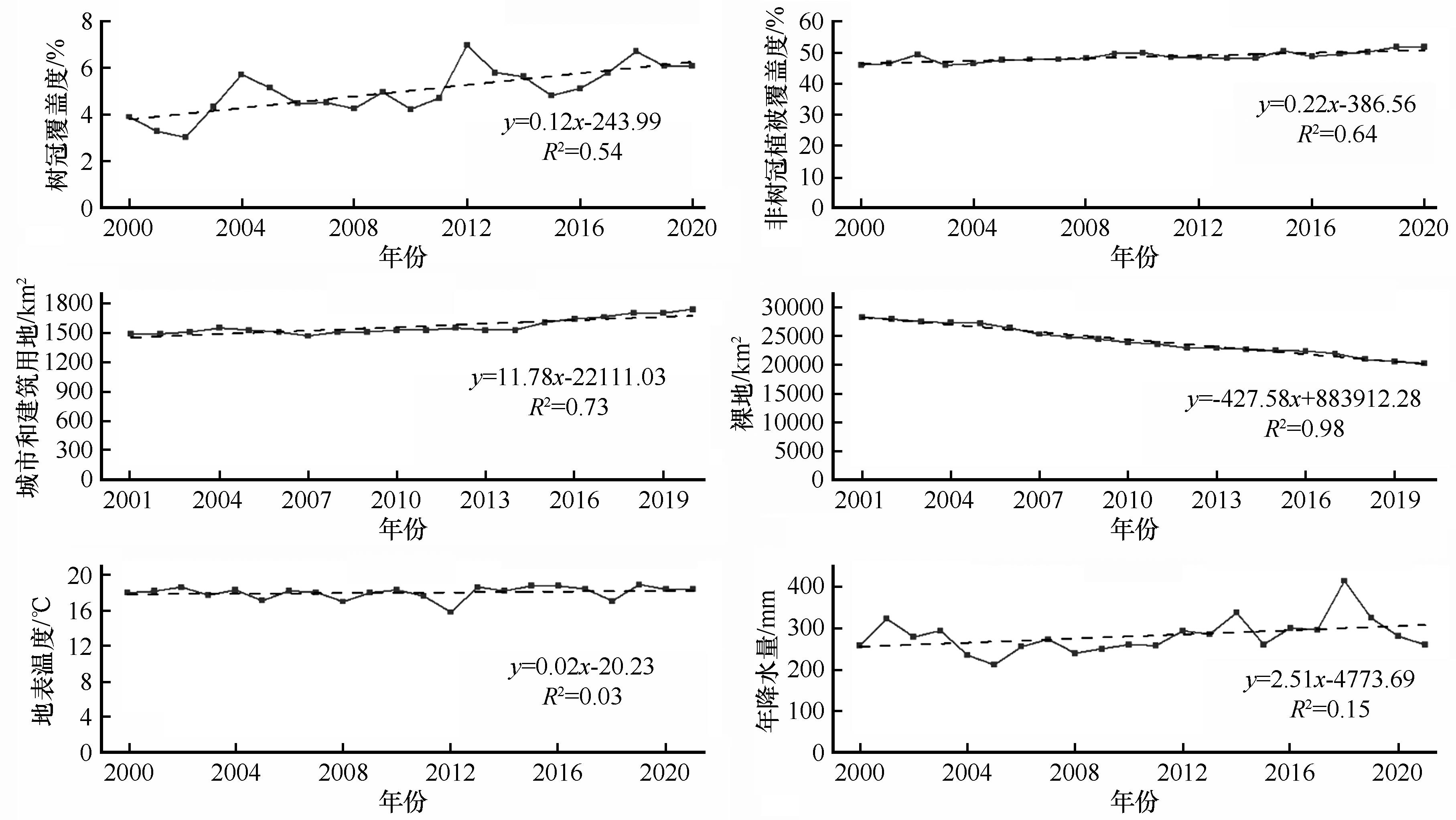
Fig. 7 Human activities and natural environmental changes in the upper Yellow River basin
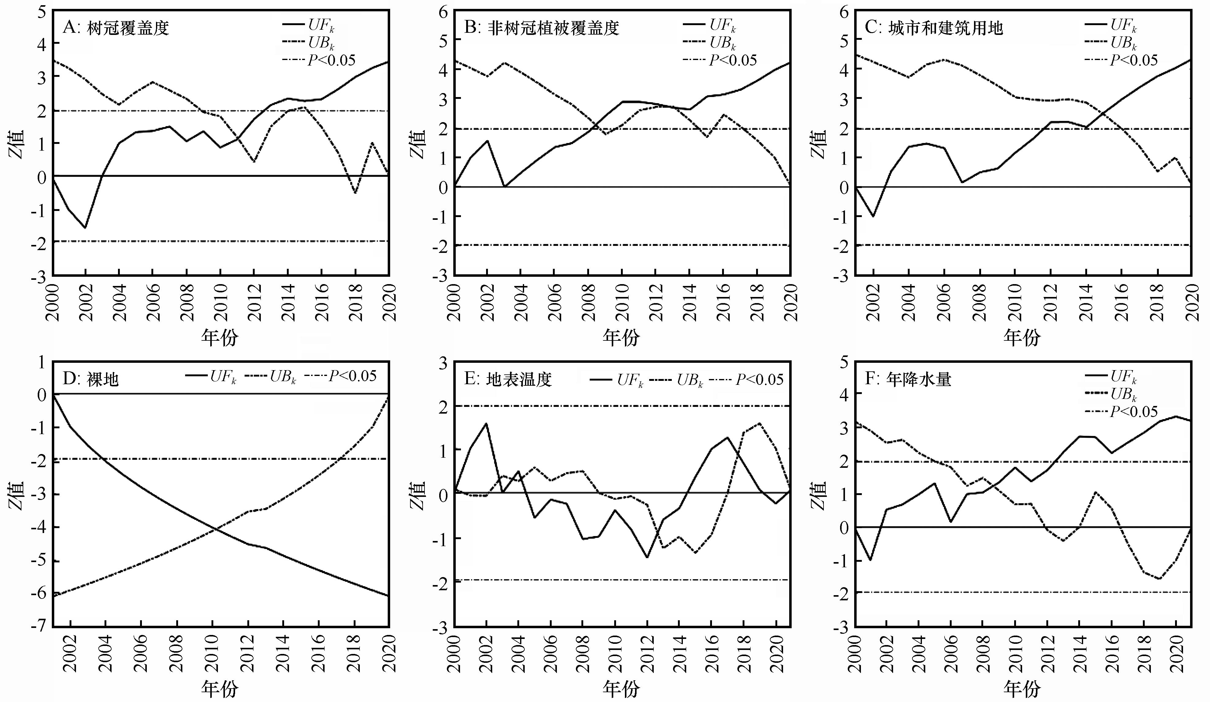
Fig. 8 The trends of factors influencing ecological environmental quality in the upper Yellow River basin based on the Mann-Kendall test
| 1 | 杨泽康,田佳,李万源,等.黄河流域生态环境质量时空格局与演变趋势[J].生态学报,2021,41(19):7627-7636. |
| 2 | 中共中央国务院印发《黄河流域生态保护和高质量发展规划纲要》[J].中华人民共和国国务院公报,2021(30):15-35. |
| 3 | 马佳宁,高艳红.近50年黄河上游流域年均降水与极端降水变化分析[J].高原气象,2019,38(1):124-135. |
| 4 | Zheng L X, Wu M Q, Cui Y T,et al.What causes the great green tide disaster in the South Yellow Sea of China in 2021?[J].Ecological Indicators,2022,140:108988. |
| 5 | Schell J.Monitoring vegetation systems in the great plains with ERTS[J].Nasa Special Publication,1973,351:309. |
| 6 | Zheng L X, Wu M Q, Zhou M,et al.Spatiotemporal distribution and influencing factors of Ulva prolifera and Sargassum and their coexistence in the South Yellow Sea,China[J].Journal of Oceanology and Limnology,2021,40(7):1070-1084. |
| 7 | Jiapaer G, Liang S L, Yi Q,et al.Vegetation dynamics and responses to recent climate change in Xinjiang using leaf area index as an indicator[J].Ecological Indicators,2015,58:64-76. |
| 8 | 璩路路,刘彦随,周扬,等.罗霄山区生态用地时空演变及其生态系统服务功能的响应:以井冈山为例[J].生态学报,2019,39(10):3468-3481. |
| 9 | 陈相标,丁文荣.滇中高原湖泊流域土地利用变化及生态系统服务功能[J].水土保持研究,2022,29(3):205-212. |
| 10 | Willis K S.Remote sensing change detection for ecological monitoring in United States protected areas[J].Biological Conservation,2015,182:233-242. |
| 11 | Zarch M A A, Malekinezhad H,Mobin,M H,et al.Drought monitoring by Reconnaissance Drought Index (RDI) in Iran[J].Water Resources Management,2011,25(13):3485-3504. |
| 12 | 徐涵秋.城市遥感生态指数的创建及其应用[J].生态学报,2013,33(24):7853-7862. |
| 13 | Shan W, Jin X B, Ren J,et al.Ecological environment quality assessment based on remote sensing data for land consolidation[J].Journal of Cleaner Production,2019,239:118126. |
| 14 | 杭鑫,罗晓春,曹云,等.基于RSEI模型的生态质量评估及城镇化影响:以南京市为例[J].应用生态学报,2020,31(1):219-229. |
| 15 | Huang H P, Chen W, Zhang Y,et al.Analysis of ecological quality in Lhasa Metropolitan Area during 1990-2017 based on remote sensing and Google Earth Engine platform[J].Journal of Geographical Sciences,2021,31(2):265-280. |
| 16 | Jing Y Q, Zhang F, He Y F,et al.Assessment of spatial and temporal variation of ecological environment quality in Ebinur Lake Wetland National Nature Reserve,Xinjiang,China[J].Ecological Indicators,2020,110:105874. |
| 17 | Qureshi S, Alavipanah S K, Konyushkova M,et al.A remotely sensed assessment of surface ecological change over the Gomishan Wetland,Iran[J].Remote Sensing,2020,12(18):2989. |
| 18 | Liu C, Yang M H, Hou Y T,et al.Spatiotemporal evolution of island ecological quality under different urban densities:a comparative analysis of Xiamen and Kinmen Islands,southeast China[J].Ecological Indicators,2021,124:107438. |
| 19 | 郝斌飞,杨洪,马明国,等.基于Google Earth Engine的三峡库区土地利用与陆表参数变化研究[J].长江流域资源与环境,2020,29(6):1343-1355. |
| 20 | Yin Q, Liu M L, Cheng J Y,et al.Mapping paddy rice planting area in northeastern China Using spatiotemporal data fusion and phenology-based method[J].Remote Sensing,2019,11(14):1699. |
| 21 | Nguyen U, Pham L, Dang D.Correction to:an automatic water detection approach using Landsat 8 OLI and Google earth engine cloud computing to map lakes and reservoirs in New Zealand[J].Environmental Monitoring and Assessment,2020,192(9):616. |
| 22 | 侯伟,马金辉,白晓.一种采用Landsat TM对ETM+SLC-off影像缝隙修补的方法[J].遥感信息,2013,28(6):72-77. |
| 23 | 徐涵秋.利用改进的归一化差异水体指数(MNDWI)提取水体信息的研究[J].遥感学报,2005(5):589-595. |
| 24 | Jimenez-Munoz J, Cristobal J, Sobrino J,et al.Revision of the single-channel algorithm for land surface temperature retrieval from Landsat thermal-infrared data[J].IEEE Transactions on Geoscience and Remote Sensing,2009,47(1):339-349. |
| 25 | Yang X Y, Meng F, Fu P J,et al.Spatiotemporal change and driving factors of the eco-environment quality in the Yangtze River Basin from 2001 to 2019[J].Ecological Indicators,2021,131:108214. |
| 26 | 都军,高军凯.1961-2014年张掖市降水变化趋势[J].中国沙漠,2017,37(4):770-774. |
| 27 | Hamed K.Trend detection in hydrologic data:the Mann-Kendall trend test under the scaling hypothesis[J].Journal of Hydrology,2008,349(3/4):350-363. |
| 28 | 董春媛,乔荣荣,王傲洁, 等.大兴安岭森林区植被物候的纬度地带性[J].生态学杂志,2022,41(12):2306-2316. |
| 29 | Martin D.An assessment of surface and zonal models of population[J].International Journal of Geographical Information Systems,1996,10(8):973-989. |
| 30 | Xiong Y, Xu W H, Lu N,et al.Assessment of spatial-temporal changes of ecological environment quality based on RSEI and GEE:a case study in Erhai Lake Basin,Yunnan province,China[J].Ecological Indicators,2021,125:107518. |
| 31 | 万鲁河,王绍巍,陈晓红.基于GeoDA的哈大齐工业走廊GDP空间关联性[J].地理研究,2011,30(6):977-984. |
| 32 | Griffith D.Spatial Autocorrelation:A Primer[M].Washington DC,USA:Association of American Geographers,1987. |
| 33 | Anselin L.Local indicators of spatial association:LISA[J].Geographical Analysis,2010,27(2):93-115. |
| 34 | 王劲峰,徐成东.地理探测器:原理与展望[J].地理学报,2017,72(1):116-134. |
| 35 | 崔文全,徐明德,李艳春,等.生态系统服务功能重要性研究[J].安全与环境工程,2014,21(2):5-9. |
| 36 | Zhang Y S, Lu X, Liu B Y,et al.Spatial relationships between ecosystem services and socioecological drivers across a large-scale region:a case study in the Yellow River Basin[J].Science of the Total Environment,2021,766:142480. |
| 37 | 杜高奇,李自强,赵勇,等.基于RSEI的黄河流域生态环境质量监测与驱动因素分析[J/OL].水利水电技术(中英文),2022:1-14. |
| 38 | 何慧娟,王钊,董金芳,等.陕西黄河流域植被变化与城镇化协同权衡关系研究:基于卫星遥感数据[J].生态学报,2022,42(9):3536-3545. |
| 39 | 逯承鹏,纪薇,刘志良,等.黄河流域甘肃段县域“三生”功能空间时空格局及影响因素识别[J].地理科学,2022,42(4):579-588. |
| 40 | 高云飞,张栋,赵帮元,等.1990-2019年黄河流域水土流失动态变化分析[J].中国水土保持,2020(10):64-67. |
| 41 | 袁丽华,蒋卫国,申文明,等.2000-2010年黄河流域植被覆盖的时空变化[J].生态学报,2013,33(24):7798-7806. |
| 42 | 高健翎,高燕,马红斌,等.黄土高原近70a水土流失治理特征研究[J].人民黄河,2019,41(11):65-69. |
| 43 | Jänicke C, Okujeni A, Cooper S,et al.Brightness gradient-corrected hyperspectral image mosaics for fractional vegetation cover mapping in northern California[J].Remote Sensing Letters,2019,11(1):1-10. |
| 44 | Piao S L, Yin G D, Tan J G,et al.Detection and attribution of vegetation greening trend in China over the last 30 years[J].Global Change Biology,2015,21(4):1601-1609. |
| [1] | Haowei Jia, Changzhen Yan, Xuegang Xing, Jiali Xie, Kun Feng. Evaluation of ecological environment in the Dulan County based on the Modified Remote Sensing Ecological Index Model [J]. Journal of Desert Research, 2021, 41(2): 181-190. |
| [2] | LAN Yong-chao;LIN Shu;LI Zhou-ying;LIU Jin-qi;MA Jian-hua. Study on Variations of Water Cycle Factors in Upper Yellow River Basin during Recent 50 Years [J]. JOURNAL OF DESERT RESEARCH, 2006, 26(5): 849-854. |
| Viewed | ||||||
|
Full text |
|
|||||
|
Abstract |
|
|||||
©2018Journal of Desert Research
Tel:0931-8267545
Email:caiedit@lzb.ac.cn;desert@lzb.ac.cn
Support:Magtech