
- CN 62-1070/P
- ISSN 1000-694X
- Bimonthly 1981
Journal of Desert Research ›› 2025, Vol. 45 ›› Issue (2): 1-16.DOI: 10.7522/j.issn.1000-694X.2024.00116
Naying Chai1,2( ), Caixia Huang1(), Zeyi Wang1, Fuqiang Li1, Wei Liu2, Meng Zhu2, Xinjun Zheng3, Xinwei Yin2
Received:2024-04-24
Revised:2024-07-30
Online:2025-03-20
Published:2025-03-26
Contact:
Caixia Huang
CLC Number:
Naying Chai, Caixia Huang, Zeyi Wang, Fuqiang Li, Wei Liu, Meng Zhu, Xinjun Zheng, Xinwei Yin. Evolution patterns and dynamic simulation of groundwater table depth in oasis areas of the Sangonghe River Basin, Xinjiang, China[J]. Journal of Desert Research, 2025, 45(2): 1-16.
Add to citation manager EndNote|Ris|BibTeX
URL: http://www.desert.ac.cn/EN/10.7522/j.issn.1000-694X.2024.00116
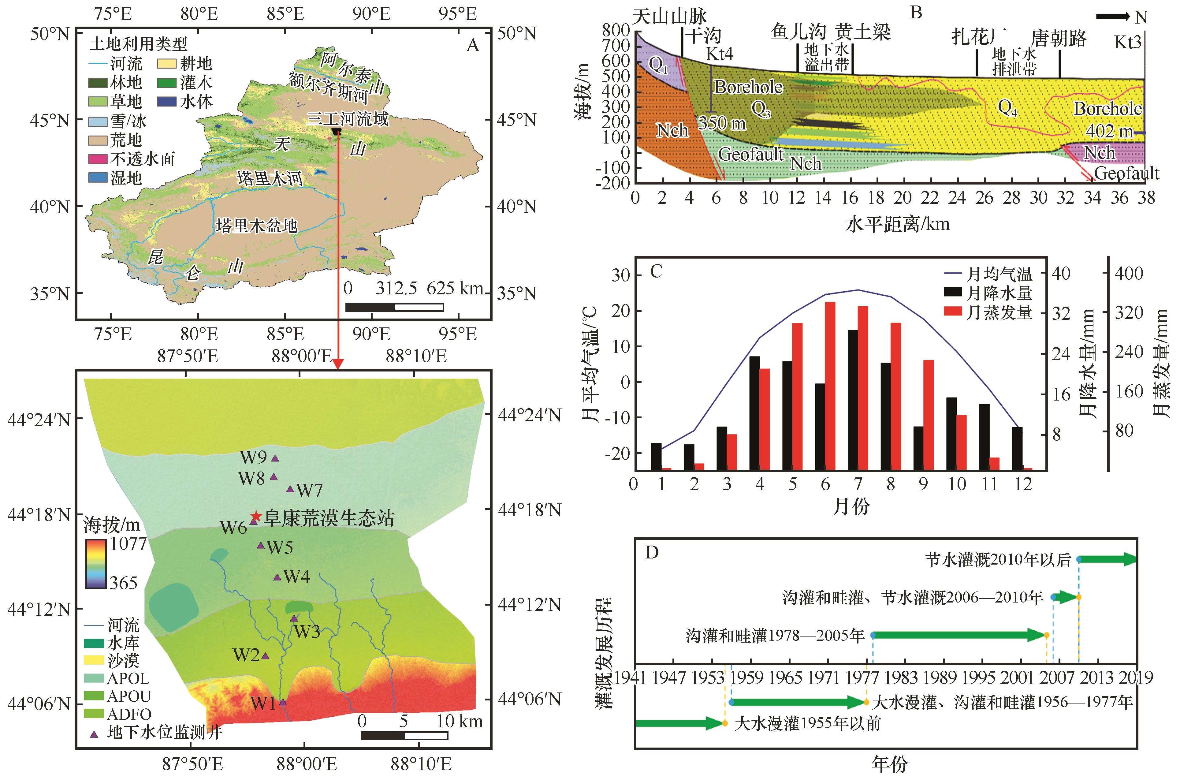
Fig.1 Schematic diagram of geographical location and distribution of groundwater level monitoring wells (A), profile of north-south aquifer structure, average monthly precipitation (B), air temperature and evaporation from 1995 to 2016 (C), and evolution of main irrigation methods (D) in the Sangong River Basin
| 监测井编号 | 水力 区域 | 海拔 /m | 经度 (E) | 纬度 (N) | 井深 /m | 井口直径/mm |
|---|---|---|---|---|---|---|
| W1 | ADFO | 690.02 | 87°58′ | 44°06′ | 30 | 325 |
| W2 | 565.51 | 87°56′ | 44°08′ | 90 | 426 | |
| W3 | 524.59 | 87°59′ | 44°11′ | 30 | 325 | |
| W4 | APOU | 497.13 | 87°57′ | 44°13′ | 25 | 377 |
| W5 | 473.70 | 87°54′ | 44°15′ | 10 | 377 | |
| W6 | 470.29 | 87°55′ | 44°17′ | 10 | 219 | |
| W7 | APOL | 464.81 | 87°52′ | 44°19′ | 10 | 377 |
| W8 | 475.37 | 87°57′ | 44°20′ | 10 | 377 | |
| W9 | 466.97 | 87°57′ | 44°21′ | 10 | 377 |
Table 1 Long-term shallow groundwater level monitoring wells (i.e., W1-W9) in oasis area of Sangong River Basin
| 监测井编号 | 水力 区域 | 海拔 /m | 经度 (E) | 纬度 (N) | 井深 /m | 井口直径/mm |
|---|---|---|---|---|---|---|
| W1 | ADFO | 690.02 | 87°58′ | 44°06′ | 30 | 325 |
| W2 | 565.51 | 87°56′ | 44°08′ | 90 | 426 | |
| W3 | 524.59 | 87°59′ | 44°11′ | 30 | 325 | |
| W4 | APOU | 497.13 | 87°57′ | 44°13′ | 25 | 377 |
| W5 | 473.70 | 87°54′ | 44°15′ | 10 | 377 | |
| W6 | 470.29 | 87°55′ | 44°17′ | 10 | 219 | |
| W7 | APOL | 464.81 | 87°52′ | 44°19′ | 10 | 377 |
| W8 | 475.37 | 87°57′ | 44°20′ | 10 | 377 | |
| W9 | 466.97 | 87°57′ | 44°21′ | 10 | 377 |
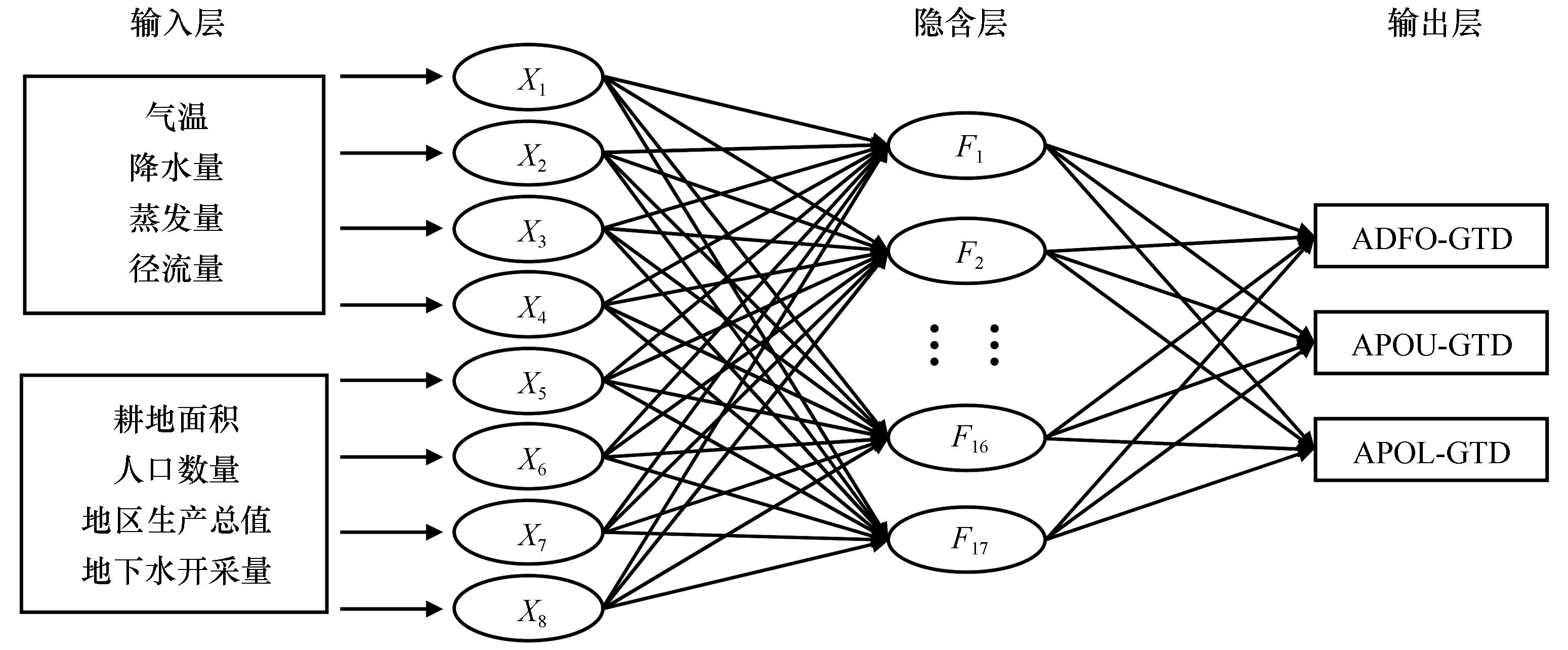
Fig.2 Mechanism diagram of groundwater table depth modelling based on BP neural network by coupling different hydraulic regions
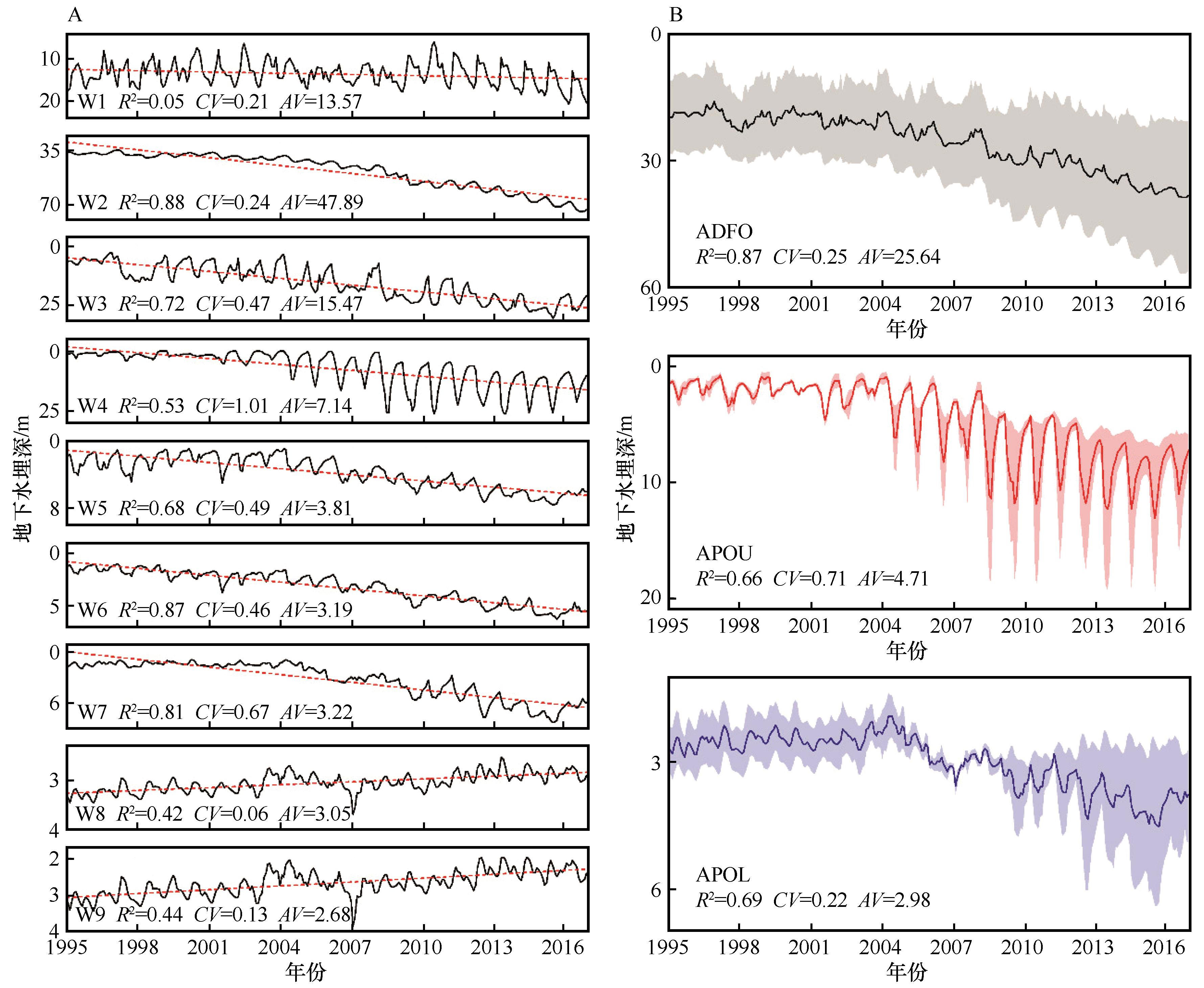
Fig.3 Characteristics of interannual variation of groundwater table depth in long-term monitoring wells (W1-W9) and the defined hydraulic areas (ADFO, APOU, and APOL) in the study area
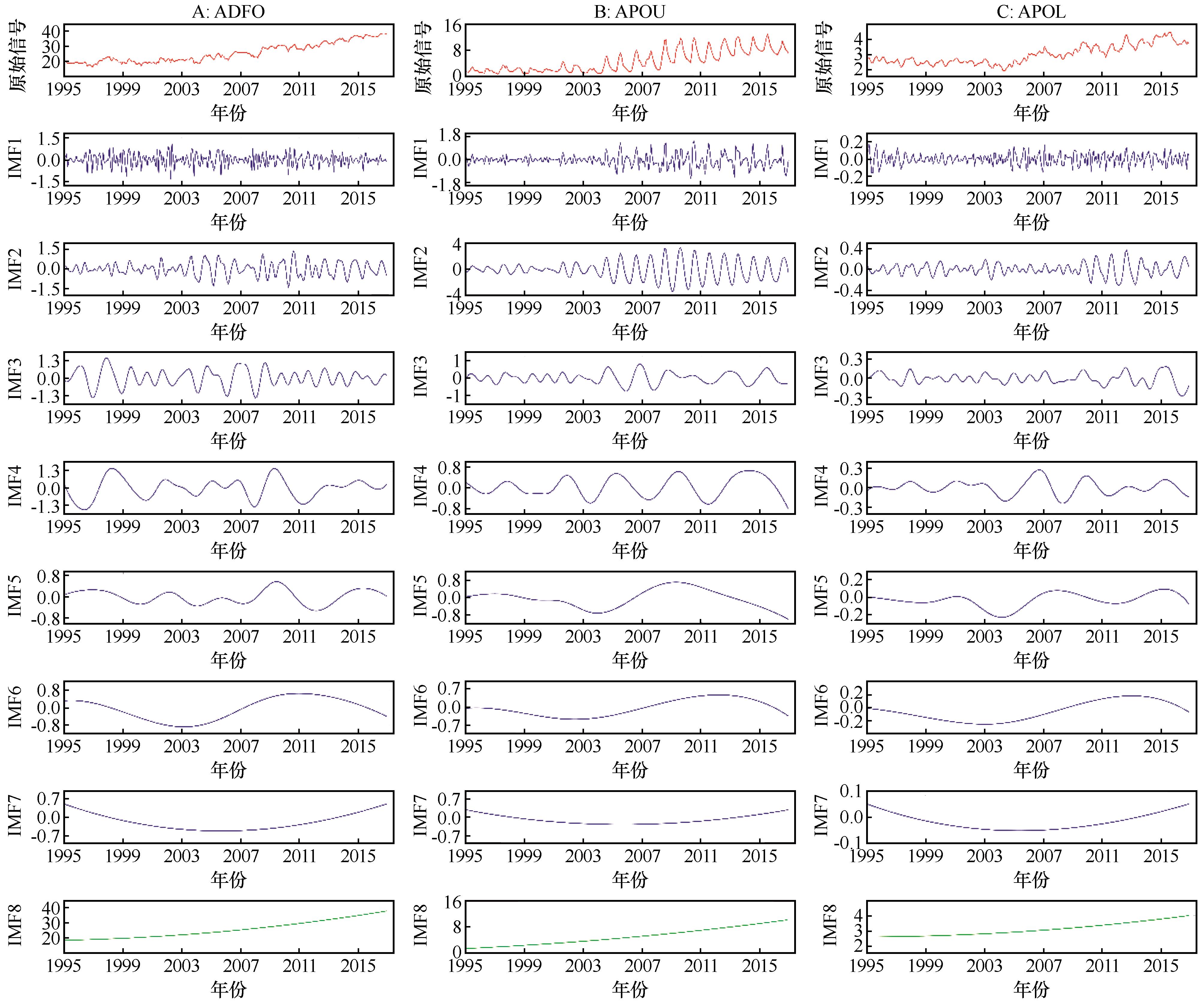
Fig.4 Results of decomposition of groundwater table depth sequence by EEMD in each defined hydraulic areas (ADFO, APOU, and APOL) in the study area
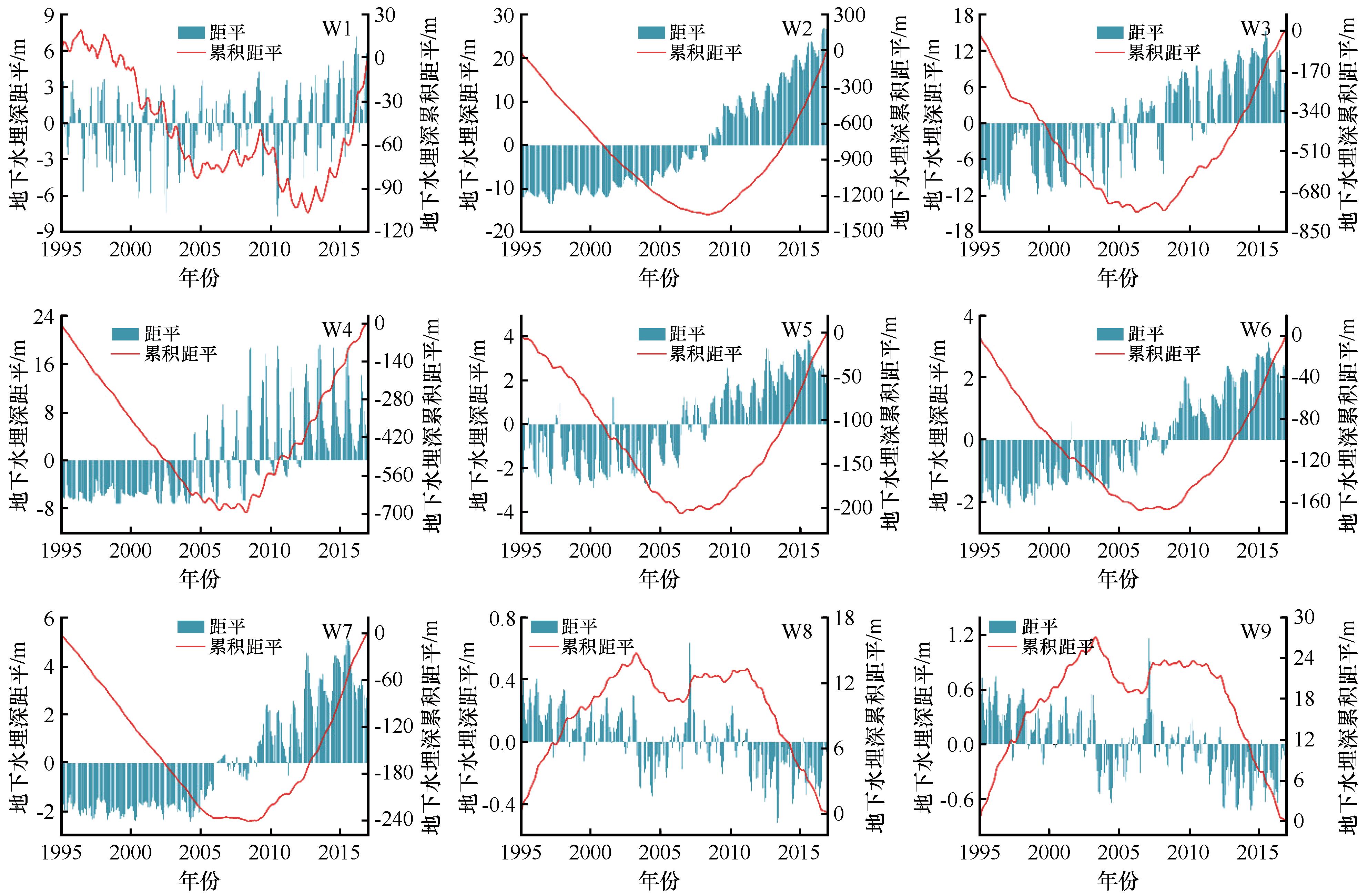
Fig.5 Cumulative anomaly curve of groundwater table depth of long-term monitoring wells (W1-W9) in the study area
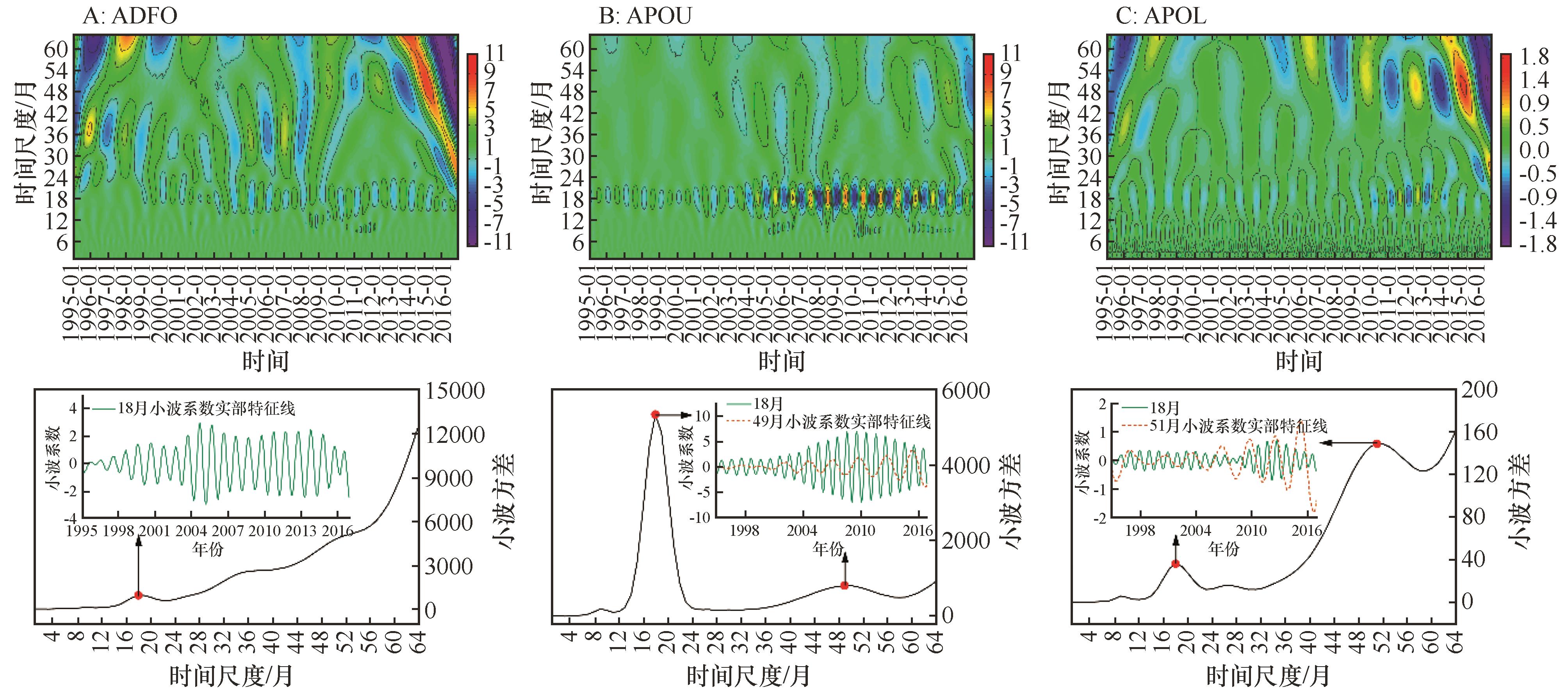
Fig.6 Isoline map, wavelet variance map and characteristic time scale curve of real part of wavelet coefficients of groundwater table depth in the defined hydraulic hydraulic areas (ADFO, APOU, and APOL) in the study area
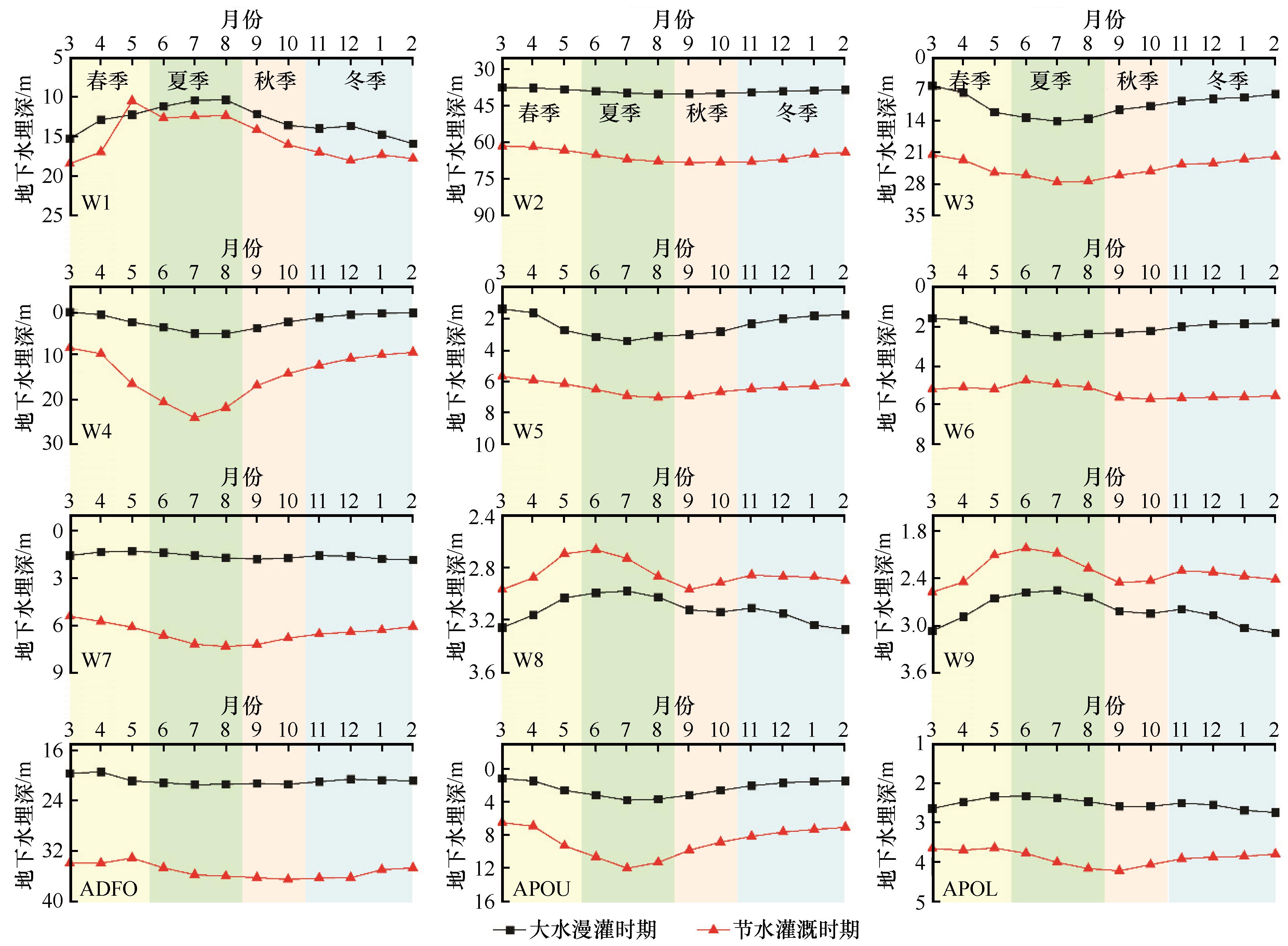
Fig.7 Variation characteristics of groundwater table depth in long-term monitoring wells (W1-W9) and the defined hydraulic areas (ADFO, APOU, and APOL) during different irrigation periods in the study area

Fig.8 Correlation analysis of groundwater table depth of long-term monitoring wells (W1-W9) during different irrigation periods in the study area
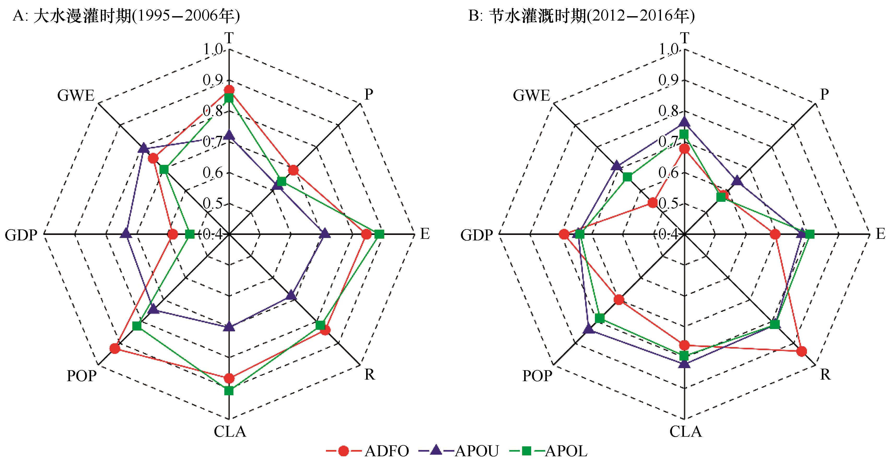
Fig.9 Correlation degree of influencing factors of groundwater table depth in different hydraulic areas (ADFO, APOU, and APOL) during different irrigation periods in this study area
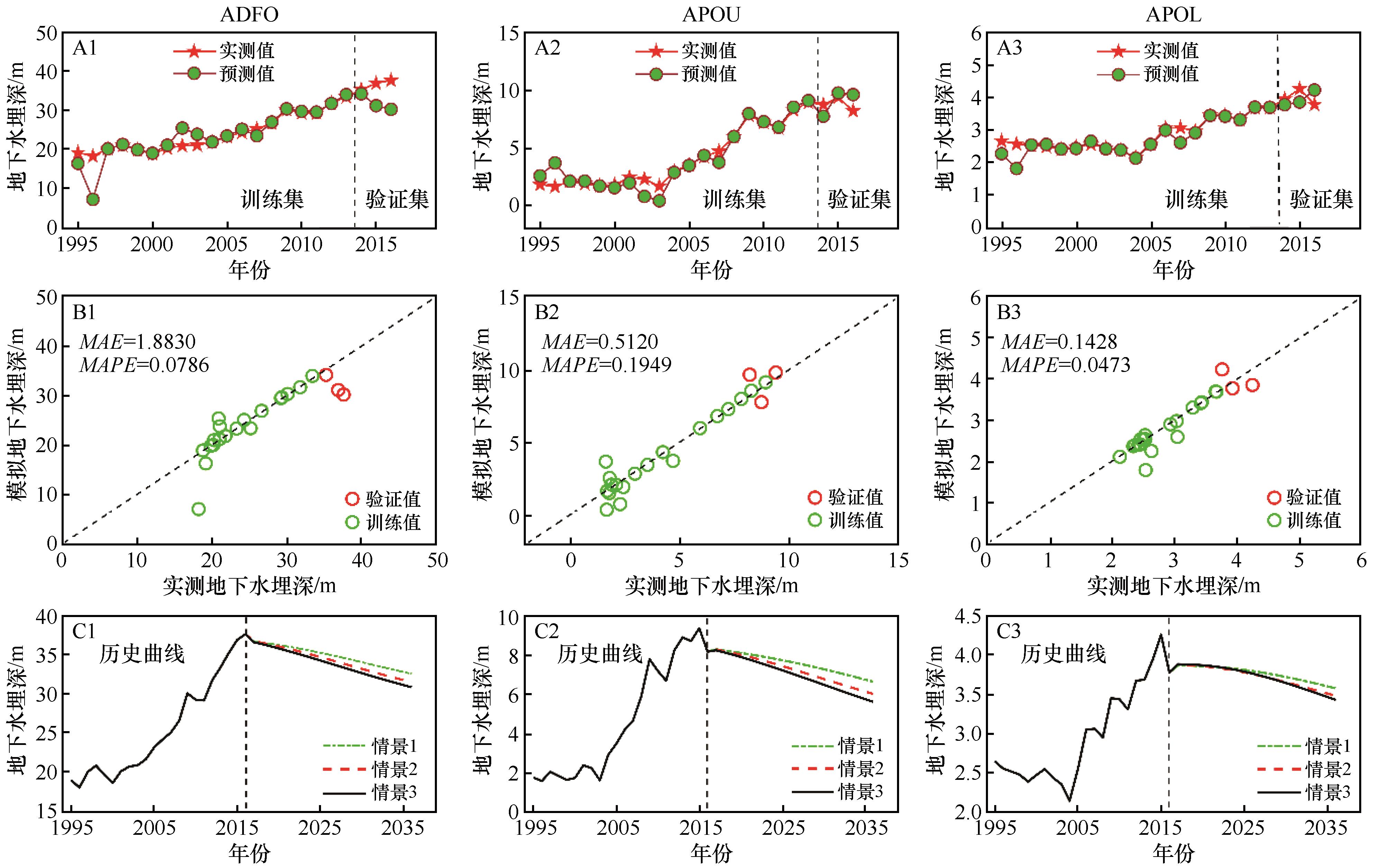
Fig.10 Simulation and prediction results of groundwater table depth in different hydraulic regions (ADFO, APOU, and APOL) based on the BP neural network
| 1 | Lall U, Josset L, Russo T.A Snapshot of the world's groundwater challenges[J].Annual Review of Environment and Resources,2020,45(1):171-194. |
| 2 | 陈雪萍,赵学勇,王瑞雄,等.气候变化与土地利用/覆被变化对中国北方农牧交错带水资源影响研究进展[J].中国沙漠,2022,42(3):170-177. |
| 3 | 王思佳,刘鹄,赵文智,等.干旱、半干旱区地下水可持续性研究评述[J].地球科学进展,2019,34(2):210-223. |
| 4 | Torres-garcía M T, Oyonarte C, Cabello J,et al.The potential of groundwater-dependent ecosystems to enhance soil biological activity and soil fertility in drylands[J].Science of The Total Environment,2022,826:154111. |
| 5 | 尹立河,张俊,王哲,等.西北内陆河流域地下水循环特征与地下水资源评价[J].中国地质,2021,48(4):1094-1111. |
| 6 | 丁宏伟,张荷生.近50年来河西走廊地下水资源变化及对生态环境的影响[J].自然资源学报,2002(6):691-697. |
| 7 | 李元寿,贾晓红,鲁文元.西北干旱区水资源利用中的生态环境问题及对策[J].水土保持研究,2006(1):217-219+242. |
| 8 | 樊自立,马英杰,艾力西尔·库尔班,等.试论中国荒漠区人工绿洲生态系统的形成演变和可持续发展[J].中国沙漠,2004,24(1):12-18. |
| 9 | 孙青言,郭辉,陆垂裕.地下水动态演变研究现状与发展趋势[J].灌溉排水学报,2021,40():58-64. |
| 10 | 吴彬,杜明亮,穆振侠,等.1956-2016年新疆平原区地下水资源量变化及其影响因素分析[J].水科学进展,2021,32(5):659-669. |
| 11 | 高宇阳,杨鹏年,阚建,等.人类活动影响下乌苏市地下水埋深演化趋势[J].灌溉排水学报,2019,38(10):90-96. |
| 12 | 阮永健,吴秀芹.基于GRACE和GLDAS的西北干旱区地下水资源量可持续性评价[J].干旱区研究,2022,39(3):787-800. |
| 13 | Li D B, Li X L, He X L,et al.Groundwater dynamic characteristics with the ecological threshold in the northwest China oasis[J].Sustainability,2022,14(9):5390. |
| 14 | 邵光成,章坤,王志宇,等.基于IABC-RBF神经网络的地下水埋深预测模型[J].浙江大学学报(工学版),2019,53(7):1323-1330. |
| 15 | Chen C, He W, Zhou H,et al.A comparative study among machine learning and numerical models for simulating groundwater dynamics in the Heihe River Basin,northwestern China[J].Scientific Reports,2020,10:3904. |
| 16 | Jasechko S, Seybold H, Perrone D,et al.Rapid groundwater decline and some cases of recovery in aquifers globally[J].Nature,2024,625:715-721. |
| 17 | Kuang X X, Liu J G, Scanlon B R,et al.The changing nature of groundwater in the global water cycle[J].Science,2024,383(6686):962. |
| 18 | 肖鲁湘,罗格平,陈曦,等.干旱区冲洪积扇-冲积平原绿洲浅层地下水质时空变化初步分析:以三工河流域绿洲为例[J].干旱区地理,2005(2):225-228. |
| 19 | 王玉朝,赵成义.三工河流域景观格局的形成与环境分异特征[J].水土保持学报,2001(3):98-101. |
| 20 | 尚海敏,王文科,段磊,等.天山北麓地下水基于生态水位的调控模拟分析[J].水土保持研究,2014,21(6):144-147. |
| 21 | 闫金凤,陈曦,罗格平,等.绿洲浅层地下水位与水质变化对人为驱动LUCC的响应:以三工河流域为例[J].自然资源学报,2005(2):172-180. |
| 22 | 陆晴,刘丽娟,王玉刚,等.新疆三工河流域农业绿洲近30年景观格局变化及其驱动力[J].生态学杂志,2013,32(3):748-754. |
| 23 | 年福华,李新.三工河流域水量转换特征及水资源利用[J].干旱区研究,2000,17(1):5-11. |
| 24 | Wu Z H, Huang N E.Ensemble empirical mode decomposition:a noise-assisted data analysis method[J].Advances in Adaptive Data Analysis,2009,1(1):1-41. |
| 25 | 罗那那,巴特尔·巴克,吴燕锋.基于集合经验模态分解北疆降水多尺度变化特征[J].水土保持研究,2017,24(4):362-367. |
| 26 | 张应华,宋献方.水文气象序列趋势分析与变异诊断的方法及其对比[J].干旱区地理,2015,38(4):652-665. |
| 27 | 常耀文,吴一晗,刘霞,等.基于小波分析的荒漠草原土壤湿度周期变化特征[J].中国草地学报,2023,45(9):87-97. |
| 28 | 束龙仓,徐丽丽,袁亚杰,等.三江平原典型区地下水流场变化及主要影响因素分析[J].水利学报,2022,53(6):644-654. |
| 29 | Deng J L.Control problems of grey systems[J].Systems & Control Letters,1982,1(5):288-294. |
| 30 | 卫磊,杨桂莲,鲁程鹏,等.华北平原超采区浅层地下水埋深变化及控制因素分析[J].水资源与水工程学报,2019,30(6):39-44. |
| 31 | 黄洲.“三条红线”条件下兵团第八师退地减水对水土资源影响及综合评估[D].石河子:石河子大学,2023. |
| 32 | 刘海丽,齐善忠,刘丽娟,等.基于地统计的新疆阜康绿洲地下水埋深空间异质性[J].生态学杂志,2018,37(5):1484-1489. |
| 33 | 管春兴,张虹波,王战,等.玛纳斯河流域山前平原区地下水资源动态变化分析[J].水利水电技术,2019,50(3):1-9. |
| 34 | 吉磊,刘兵,何新林,等.玛纳斯河下游灌区地下水埋深变化特征及成因分析[J].灌溉排水学报,2015,34(9):59-65. |
| 35 | 刘志明,王贵玲,蔺文静.石羊河流域平原地下水位动态特征与监测网观测频率优化[J].中国沙漠,2006,26(1):85-89. |
| 36 | 陈社明,卢文喜,罗建男,等.内蒙古德岭山地区灌溉农业发展对浅层地下水系统演化的影响[J].农业工程学报,2012,28(3):1-7. |
| 37 | 丁启振,周金龙,杜明亮,等.新疆石河子-昌吉地区2016-2020年地下水位动态特征分析[J].灌溉排水学报,2022,41(2):109-117. |
| 38 | 米丽娜,肖洪浪,朱文婧,等.1985-2013年黑河中游流域地下水位动态变化特征[J].冰川冻土,2015,37(2):461-469. |
| 39 | 宋子奕,鲁程鹏,吴成城,等.2009-2019年河西走廊地下水位时空分布及演变趋势[J].水资源保护,2023,39(2):160-167. |
| 40 | 崔佳琪,李仙岳,史海滨,等.节水改造前后永济灌域地下水环境时空变化特征[J].干旱区研究,2022,39(3):841-852. |
| 41 | 陈彬鑫,何新林,杨丽莉,等.莫索湾灌区近22年来地下水埋深变化及影响因素分析[J].干旱区资源与环境,2020,34(12):155-160. |
| 42 | 陈泽,吴彬,高凡,等.2011-2020年新疆鄯善县地下水位时空动态变化规律[J].水土保持通报,2023,43(2):60-68. |
| 43 | 陈永金,艾克热木·阿布拉,张天举,等.塔里木河下游生态输水对地下水埋深变化的影响[J].干旱区地理,2021,44(3):651-658. |
| 44 | 张震域,赵沛,畅祥生,等.额济纳绿洲1992-2015年地下水埋深变化分析[J].人民黄河,2019,41(7):33-37. |
| 45 | 缑天宇,佟玲,康德奎,等.中国西北干旱区石羊河流域重点治理综合效应评价[J].农业工程学报,2022,38(12):74-84. |
| 46 | 杨怀德,冯起,郭小燕.1999-2013年民勤绿洲地下水埋深年际变化动态及影响因素[J].中国沙漠,2017,37(3):562-570. |
| 47 | 刘媛媛,刘业森,郑敬伟,等.BP神经网络和数值模型相结合的城市内涝预测方法研究[J].水利学报,2022,53(3):284-295. |
| 48 | 薛萍,张召,雷晓辉,等.基于BP神经网络的不同时间尺度泵站前池水位预测模型[J].南水北调与水利科技(中英文),2022,20(2):393-407. |
| 49 | 王虹,魏秉炎,王昊云.基于主成分分析的BP神经网络模型在铁矿产地溯源中的应用[J].冶金分析,2021,41(9):11-17. |
| 50 | 杜云皓,仇锦先,冯绍元.改进GA-BP模型在地下水位埋深预测中的应用[J].节水灌溉,2017(9):81-84. |
| 51 | 陈曦,夏军,钱静,等.三工河流域分布式水文模型研究[J].干旱区地理,2003,26(4):305-308. |
| 52 | 张叶,刘兵,何新林,等.干旱灌区地下水位动态变化及驱动因素分析[J].节水灌溉,2017(6):63-67. |
| 53 | 魏兴,贾瑞亮,周金龙,等.新疆玛纳斯河流域典型剖面地下水位动态分析[J].南水北调与水利科技,2017,15(5):127-133. |
| 54 | 李彦,郑新军,王玉刚,等.绿洲-荒漠共生关系实验模拟平台(绿洲-荒漠平台)[J].中国科学院院刊,2021,36(12):1506-1514. |
| [1] | Mingna Wang, Dinghai Zhang, Zhishan Zhang, Lining Lu. Canopy width prediction models for the Gurbantunggut Desert [J]. Journal of Desert Research, 2022, 42(4): 139-150. |
| [2] | Nie Min, Liu Zhihui, Liu Yang, Yao Junqiang. Runoff Forecast Based on Principal Component Analysis and BP Neural Network [J]. JOURNAL OF DESERT RESEARCH, 2016, 36(4): 1144-1152. |
| [3] | Liu Honglan, Zhang Qiang, Zhang Junguo, Wang Haibo, Wen Xiaoyan. Application of the BP Neural Network Model in Summer Drought Prediction: a case in the Hexi Corridor [J]. JOURNAL OF DESERT RESEARCH, 2015, 35(2): 474-478. |
| [4] | Shamsiya·Anwar, Tashpolat·Tiyip, Wang Hongwei, Mamat·Sawut, Zhang Fei. Application of Artificial Intelligent Technique for Predicting Soil Salinity in a Typical Oasis of Arid Area in Xinjiang, China [J]. JOURNAL OF DESERT RESEARCH, 2014, 34(1): 153-161. |
| [5] | ZHANG Xin-huan1, WANG Fei1,2, HOU Yan-jun3, ZHANG Wen-biao1,2. Difference and Cause of Two Typical Cropland Landscapes in the Sangong River Basin, Xinjiang, China [J]. JOURNAL OF DESERT RESEARCH, 2012, 32(6): 1786-1793. |
| [6] | ZUO He-jun;GOU Mang-mang;LI Gang-tie;LI Xing. Study on Sandstorm Forecasting with BP Neural Network Method [J]. JOURNAL OF DESERT RESEARCH, 2010, 30(1): 193-197. |
| [7] | YIN Chang-ying;LUO Ge-ping;TANG Fa-shu;. Dynamic Simulation and Analysis of Oasis Land Use Spatial Pattern at Town-Scale [J]. JOURNAL OF DESERT RESEARCH, 2009, 29(1): 68-75. |
| Viewed | ||||||
|
Full text |
|
|||||
|
Abstract |
|
|||||
©2018Journal of Desert Research
Tel:0931-8267545
Email:caiedit@lzb.ac.cn;desert@lzb.ac.cn
Support:Magtech