Projecting avian response to linked changes in groundwater and riparian floodplain vegetation along a dryland river:a scenario analysis
1
2011
... 地下水是维系干旱区生态功能的核心资源[1 ] .干旱区降水稀少、地表水匮乏,但地下水资源相对丰富[2 ] ;在浅埋条件下(埋深≤10 m),地下水与包气带土壤水联系紧密,并不同程度参与植被蒸散发过程,植被部分甚至完全依赖地下水生存[3 ] .地下水参与植被蒸散发的强度即为地下水蒸散发(Groundwater evapotranspiration,ET g ),包含通过地表土壤蒸发(E g )和植被蒸腾(T g )消耗的地下水量[4 -6 ] .ET g 是地下水浅埋环境中垂向水文循环的重要组分[7 ] ,是干旱区地下水最主要的自然排泄方式(>70%)[8 ] .ET g 的动态变化影响滨水系统(如河岸林、绿洲湿地等脆弱生态系统)水平衡动态[6 ,9 -10 ] 、土壤盐渍化过程[11 ] 、农田生产力的形成[12 ] ,以及固沙植被分布等[13 ] .所以,准确估算ET g 及其在实际蒸散发(Actual evapotranspiration, ET a )的占比对科学管理干旱区农业与水资源[14 -15 ] 、合理保护和修复地下水依赖型植被(Groundwater-dependent vegetations,GDV)意义重大[16 -18 ] .但是,ET g 受区域气候特征[19 -20 ] 、局地地下水波动规律[21 ] 、土地利用类型[14 ] 、土壤储水能力、植被根系分布等多种因素影响[22 -23 ] ,且与不同环境要素之间存在复杂的非线性关系,准确估算ET g 目前仍然是生态学与水文学中的难点[24 ] . ...
A study of soil water movement combining soil water potential with stable isotopes at two sites of shallow groundwater areas in the North China Plain
1
2009
... 地下水是维系干旱区生态功能的核心资源[1 ] .干旱区降水稀少、地表水匮乏,但地下水资源相对丰富[2 ] ;在浅埋条件下(埋深≤10 m),地下水与包气带土壤水联系紧密,并不同程度参与植被蒸散发过程,植被部分甚至完全依赖地下水生存[3 ] .地下水参与植被蒸散发的强度即为地下水蒸散发(Groundwater evapotranspiration,ET g ),包含通过地表土壤蒸发(E g )和植被蒸腾(T g )消耗的地下水量[4 -6 ] .ET g 是地下水浅埋环境中垂向水文循环的重要组分[7 ] ,是干旱区地下水最主要的自然排泄方式(>70%)[8 ] .ET g 的动态变化影响滨水系统(如河岸林、绿洲湿地等脆弱生态系统)水平衡动态[6 ,9 -10 ] 、土壤盐渍化过程[11 ] 、农田生产力的形成[12 ] ,以及固沙植被分布等[13 ] .所以,准确估算ET g 及其在实际蒸散发(Actual evapotranspiration, ET a )的占比对科学管理干旱区农业与水资源[14 -15 ] 、合理保护和修复地下水依赖型植被(Groundwater-dependent vegetations,GDV)意义重大[16 -18 ] .但是,ET g 受区域气候特征[19 -20 ] 、局地地下水波动规律[21 ] 、土地利用类型[14 ] 、土壤储水能力、植被根系分布等多种因素影响[22 -23 ] ,且与不同环境要素之间存在复杂的非线性关系,准确估算ET g 目前仍然是生态学与水文学中的难点[24 ] . ...
Describing the spatial-temporal dynamics of groundwater-dependent vegetation (GDV):a theoretical methodology
1
2018
... 地下水是维系干旱区生态功能的核心资源[1 ] .干旱区降水稀少、地表水匮乏,但地下水资源相对丰富[2 ] ;在浅埋条件下(埋深≤10 m),地下水与包气带土壤水联系紧密,并不同程度参与植被蒸散发过程,植被部分甚至完全依赖地下水生存[3 ] .地下水参与植被蒸散发的强度即为地下水蒸散发(Groundwater evapotranspiration,ET g ),包含通过地表土壤蒸发(E g )和植被蒸腾(T g )消耗的地下水量[4 -6 ] .ET g 是地下水浅埋环境中垂向水文循环的重要组分[7 ] ,是干旱区地下水最主要的自然排泄方式(>70%)[8 ] .ET g 的动态变化影响滨水系统(如河岸林、绿洲湿地等脆弱生态系统)水平衡动态[6 ,9 -10 ] 、土壤盐渍化过程[11 ] 、农田生产力的形成[12 ] ,以及固沙植被分布等[13 ] .所以,准确估算ET g 及其在实际蒸散发(Actual evapotranspiration, ET a )的占比对科学管理干旱区农业与水资源[14 -15 ] 、合理保护和修复地下水依赖型植被(Groundwater-dependent vegetations,GDV)意义重大[16 -18 ] .但是,ET g 受区域气候特征[19 -20 ] 、局地地下水波动规律[21 ] 、土地利用类型[14 ] 、土壤储水能力、植被根系分布等多种因素影响[22 -23 ] ,且与不同环境要素之间存在复杂的非线性关系,准确估算ET g 目前仍然是生态学与水文学中的难点[24 ] . ...
An empirical approach simulating evapotranspiration from groundwater under different soil water conditions
2
2012
... 地下水是维系干旱区生态功能的核心资源[1 ] .干旱区降水稀少、地表水匮乏,但地下水资源相对丰富[2 ] ;在浅埋条件下(埋深≤10 m),地下水与包气带土壤水联系紧密,并不同程度参与植被蒸散发过程,植被部分甚至完全依赖地下水生存[3 ] .地下水参与植被蒸散发的强度即为地下水蒸散发(Groundwater evapotranspiration,ET g ),包含通过地表土壤蒸发(E g )和植被蒸腾(T g )消耗的地下水量[4 -6 ] .ET g 是地下水浅埋环境中垂向水文循环的重要组分[7 ] ,是干旱区地下水最主要的自然排泄方式(>70%)[8 ] .ET g 的动态变化影响滨水系统(如河岸林、绿洲湿地等脆弱生态系统)水平衡动态[6 ,9 -10 ] 、土壤盐渍化过程[11 ] 、农田生产力的形成[12 ] ,以及固沙植被分布等[13 ] .所以,准确估算ET g 及其在实际蒸散发(Actual evapotranspiration, ET a )的占比对科学管理干旱区农业与水资源[14 -15 ] 、合理保护和修复地下水依赖型植被(Groundwater-dependent vegetations,GDV)意义重大[16 -18 ] .但是,ET g 受区域气候特征[19 -20 ] 、局地地下水波动规律[21 ] 、土地利用类型[14 ] 、土壤储水能力、植被根系分布等多种因素影响[22 -23 ] ,且与不同环境要素之间存在复杂的非线性关系,准确估算ET g 目前仍然是生态学与水文学中的难点[24 ] . ...
... 针对ET g 的研究最早可以追溯到20世纪初,学者报道了美国犹他州北部ET g 与地下水位之间存在相关性[25 -26 ] ;Shaw等[27 ] 发现埋深<3 m时地下水参与沙壤土与壤土蒸发过程的强度(E g )相对显著;Gardner[28 ] 、Willis[29 ] 发现E g 与地下水位之间的函数关系很大程度上取决于土壤质地.近30年来出现了大量关于ET g 的观测与模拟研究工作,各种直接(如地下水蒸渗仪、根系液流等)[23 ,30 -32 ] 或间接观测手段(如基于水量平衡观测)日趋增多[33 -35 ] ,用于估算ET g 的方法(如各种经验关系甚至机制模型)不断出现[17 ,36 ] .但是,这些观测手段普遍费用较高[37 ] ,相关的估算方法也通常存在边界条件限制与参数不确定性问题[4 ,38 ] .大量研究表明,土壤水分与地下水位对地球关键带中发生的重要生态水文过程(如蒸散发、渗漏过程等)具有一定的记忆效应[39 -40 ] ,如何利用可以相对方便、大量获得的常规观测数据,通过数据驱动方法估算不便或不易直接观测的水文变量(如ET g )已经成为生态-水文学中的研究热点和全新方向[23 ,41 ] ,但在技术上仍存在挑战[38 ,42 ] . ...
Evapotranspiration Estimates with Emphasis on Groundwater Evapotranspiration in Texas
1
... 干旱半干旱区环境中,地下水系统受ET g 影响表现出明显的昼夜波动特征,基于地下水位的昼夜波动规律可实现ET g 的估算[23 ] .地下水位波动法(Water Table Fluctuation, WTF)所需的数据容易获取,且实现过程相对简单[5 ] ,是ET g 估算中出现最早、使用最广泛的方法[43 -47 ] .受地下水毛细上升补给和植物根系提水过程影响,土壤水分动态也表现出与地下水位相似的昼夜波动规律[26 ,48 -49 ] ,因此利用土壤水分观测数据,并借鉴地下水位波动法的思路可实现地下水浅埋环境ET a 的估算(即土壤水分波动法,Soil Moisture Fluctuation, SMF).结合WTF与SMF方法即可确定地下水参与蒸散发的大致比例.本文以河西走廊中段的荒漠绿洲过渡带的典型植被沙枣(Elaeagnus angustifolia )林为例,通过地下水位波动法与土壤水分波动法估算ET g 强度和比例,评估数据驱动方法在荒漠绿洲过渡带地下水浅埋环境ET g 量化评估中的可行性,结果将为该地区水量平衡分析与地下水依赖型植被保护提供科学依据. ...
地下水依赖型生态系统生态水文研究进展
3
2018
... 地下水是维系干旱区生态功能的核心资源[1 ] .干旱区降水稀少、地表水匮乏,但地下水资源相对丰富[2 ] ;在浅埋条件下(埋深≤10 m),地下水与包气带土壤水联系紧密,并不同程度参与植被蒸散发过程,植被部分甚至完全依赖地下水生存[3 ] .地下水参与植被蒸散发的强度即为地下水蒸散发(Groundwater evapotranspiration,ET g ),包含通过地表土壤蒸发(E g )和植被蒸腾(T g )消耗的地下水量[4 -6 ] .ET g 是地下水浅埋环境中垂向水文循环的重要组分[7 ] ,是干旱区地下水最主要的自然排泄方式(>70%)[8 ] .ET g 的动态变化影响滨水系统(如河岸林、绿洲湿地等脆弱生态系统)水平衡动态[6 ,9 -10 ] 、土壤盐渍化过程[11 ] 、农田生产力的形成[12 ] ,以及固沙植被分布等[13 ] .所以,准确估算ET g 及其在实际蒸散发(Actual evapotranspiration, ET a )的占比对科学管理干旱区农业与水资源[14 -15 ] 、合理保护和修复地下水依赖型植被(Groundwater-dependent vegetations,GDV)意义重大[16 -18 ] .但是,ET g 受区域气候特征[19 -20 ] 、局地地下水波动规律[21 ] 、土地利用类型[14 ] 、土壤储水能力、植被根系分布等多种因素影响[22 -23 ] ,且与不同环境要素之间存在复杂的非线性关系,准确估算ET g 目前仍然是生态学与水文学中的难点[24 ] . ...
... [6 ,9 -10 ]、土壤盐渍化过程[11 ] 、农田生产力的形成[12 ] ,以及固沙植被分布等[13 ] .所以,准确估算ET g 及其在实际蒸散发(Actual evapotranspiration, ET a )的占比对科学管理干旱区农业与水资源[14 -15 ] 、合理保护和修复地下水依赖型植被(Groundwater-dependent vegetations,GDV)意义重大[16 -18 ] .但是,ET g 受区域气候特征[19 -20 ] 、局地地下水波动规律[21 ] 、土地利用类型[14 ] 、土壤储水能力、植被根系分布等多种因素影响[22 -23 ] ,且与不同环境要素之间存在复杂的非线性关系,准确估算ET g 目前仍然是生态学与水文学中的难点[24 ] . ...
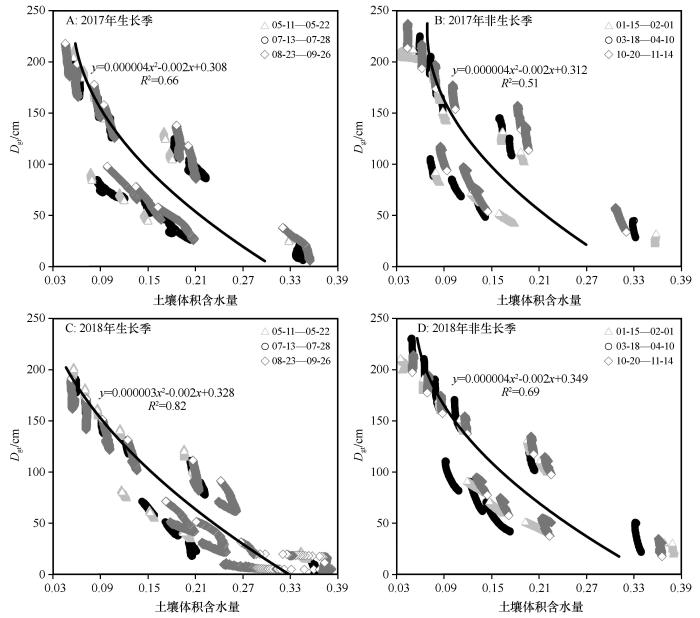
... 干旱半干旱环境中,地下水系统与植被过程之间存在着复杂的关联关系[13 ] .植被对地下水响应的深度通常小于10 m[64 ] ,在影响范围内,植被对地下水的响应特征受多种环境因子影响[65 ] ,如蒸散发强度随埋深增加呈反‘S’形下降,但拐点却随土壤水力参数、地下水养分/盐分含量变化[66 -68 ] ;地下水参与不同植被蒸散发(ET g )也会因为地上/地下生物量的分配格局[69 ] 及其用水策略存在较大差异[6 ,70 -72 ] .地下水位较浅且植被、土壤和水文条件一致的情况下,ET g 与大气蒸发高度相关;随着埋深增加,土壤输水能力成为影响ET g 的主要因素[18 ] .针对沙枣林样地的回归分析表明,潜在蒸散发、土壤储水量、地下水位与ET g 存在显著正相关关系.潜在蒸散发体现了植被需水的程度,而前期土壤储水量反映了土壤自身的水分供给能力,二者直接决定了植被对地下水的依赖程度;地下水位则代表了植被对地下水资源获取的难易程度.潜在蒸散发、土壤储水量、地下水位对ET g 变化方差的贡献率在2017年和2018年依次分别为48%、21%、31%和24%、24%、52%,该比例可能随样地生态-水文条件发生较大变化.植被本身对水分的利用规律也是影响ET g 的重要原因,但沙枣作为干旱区典型植物,生理过程对水分资源的需求均趋于保守,既保持较低的碳同化速率、同时维持较低的水分需求,以确保水分供给不受或少受环境胁迫的影响.本文获得的生长季ET a 、ET g 均较大,主要原因可能是样地中水分供给条件优越,导致土壤蒸发过程强烈,因此植物蒸腾所占实际蒸散发的比例可能相对较低,但受本文研究方法和研究数据的限制,尚无法确定准确的比例关系;此外,本研究缺少生长季内详细的植被参数和地下水养分/盐分等信息,且地下水波动范围相对较窄,尚无法建立更完整的ET g 对重要环境变量的响应关系. ...
Extinction depth and evapotranspiration from ground water under selected land covers
1
2010
... 地下水是维系干旱区生态功能的核心资源[1 ] .干旱区降水稀少、地表水匮乏,但地下水资源相对丰富[2 ] ;在浅埋条件下(埋深≤10 m),地下水与包气带土壤水联系紧密,并不同程度参与植被蒸散发过程,植被部分甚至完全依赖地下水生存[3 ] .地下水参与植被蒸散发的强度即为地下水蒸散发(Groundwater evapotranspiration,ET g ),包含通过地表土壤蒸发(E g )和植被蒸腾(T g )消耗的地下水量[4 -6 ] .ET g 是地下水浅埋环境中垂向水文循环的重要组分[7 ] ,是干旱区地下水最主要的自然排泄方式(>70%)[8 ] .ET g 的动态变化影响滨水系统(如河岸林、绿洲湿地等脆弱生态系统)水平衡动态[6 ,9 -10 ] 、土壤盐渍化过程[11 ] 、农田生产力的形成[12 ] ,以及固沙植被分布等[13 ] .所以,准确估算ET g 及其在实际蒸散发(Actual evapotranspiration, ET a )的占比对科学管理干旱区农业与水资源[14 -15 ] 、合理保护和修复地下水依赖型植被(Groundwater-dependent vegetations,GDV)意义重大[16 -18 ] .但是,ET g 受区域气候特征[19 -20 ] 、局地地下水波动规律[21 ] 、土地利用类型[14 ] 、土壤储水能力、植被根系分布等多种因素影响[22 -23 ] ,且与不同环境要素之间存在复杂的非线性关系,准确估算ET g 目前仍然是生态学与水文学中的难点[24 ] . ...
Estimated ground-water discharge by evapotranspiration,Ash Meadows area,Nye County,Nevada,1994
1
1997
... 地下水是维系干旱区生态功能的核心资源[1 ] .干旱区降水稀少、地表水匮乏,但地下水资源相对丰富[2 ] ;在浅埋条件下(埋深≤10 m),地下水与包气带土壤水联系紧密,并不同程度参与植被蒸散发过程,植被部分甚至完全依赖地下水生存[3 ] .地下水参与植被蒸散发的强度即为地下水蒸散发(Groundwater evapotranspiration,ET g ),包含通过地表土壤蒸发(E g )和植被蒸腾(T g )消耗的地下水量[4 -6 ] .ET g 是地下水浅埋环境中垂向水文循环的重要组分[7 ] ,是干旱区地下水最主要的自然排泄方式(>70%)[8 ] .ET g 的动态变化影响滨水系统(如河岸林、绿洲湿地等脆弱生态系统)水平衡动态[6 ,9 -10 ] 、土壤盐渍化过程[11 ] 、农田生产力的形成[12 ] ,以及固沙植被分布等[13 ] .所以,准确估算ET g 及其在实际蒸散发(Actual evapotranspiration, ET a )的占比对科学管理干旱区农业与水资源[14 -15 ] 、合理保护和修复地下水依赖型植被(Groundwater-dependent vegetations,GDV)意义重大[16 -18 ] .但是,ET g 受区域气候特征[19 -20 ] 、局地地下水波动规律[21 ] 、土地利用类型[14 ] 、土壤储水能力、植被根系分布等多种因素影响[22 -23 ] ,且与不同环境要素之间存在复杂的非线性关系,准确估算ET g 目前仍然是生态学与水文学中的难点[24 ] . ...
On evapotranspiration and shallow groundwater fluctuations:a fourier-based improvement to the white method and the role of specific yield under saturated conditions
1
2011
... 地下水是维系干旱区生态功能的核心资源[1 ] .干旱区降水稀少、地表水匮乏,但地下水资源相对丰富[2 ] ;在浅埋条件下(埋深≤10 m),地下水与包气带土壤水联系紧密,并不同程度参与植被蒸散发过程,植被部分甚至完全依赖地下水生存[3 ] .地下水参与植被蒸散发的强度即为地下水蒸散发(Groundwater evapotranspiration,ET g ),包含通过地表土壤蒸发(E g )和植被蒸腾(T g )消耗的地下水量[4 -6 ] .ET g 是地下水浅埋环境中垂向水文循环的重要组分[7 ] ,是干旱区地下水最主要的自然排泄方式(>70%)[8 ] .ET g 的动态变化影响滨水系统(如河岸林、绿洲湿地等脆弱生态系统)水平衡动态[6 ,9 -10 ] 、土壤盐渍化过程[11 ] 、农田生产力的形成[12 ] ,以及固沙植被分布等[13 ] .所以,准确估算ET g 及其在实际蒸散发(Actual evapotranspiration, ET a )的占比对科学管理干旱区农业与水资源[14 -15 ] 、合理保护和修复地下水依赖型植被(Groundwater-dependent vegetations,GDV)意义重大[16 -18 ] .但是,ET g 受区域气候特征[19 -20 ] 、局地地下水波动规律[21 ] 、土地利用类型[14 ] 、土壤储水能力、植被根系分布等多种因素影响[22 -23 ] ,且与不同环境要素之间存在复杂的非线性关系,准确估算ET g 目前仍然是生态学与水文学中的难点[24 ] . ...
干旱、半干旱区地下水可持续性研究评述
1
2019
... 地下水是维系干旱区生态功能的核心资源[1 ] .干旱区降水稀少、地表水匮乏,但地下水资源相对丰富[2 ] ;在浅埋条件下(埋深≤10 m),地下水与包气带土壤水联系紧密,并不同程度参与植被蒸散发过程,植被部分甚至完全依赖地下水生存[3 ] .地下水参与植被蒸散发的强度即为地下水蒸散发(Groundwater evapotranspiration,ET g ),包含通过地表土壤蒸发(E g )和植被蒸腾(T g )消耗的地下水量[4 -6 ] .ET g 是地下水浅埋环境中垂向水文循环的重要组分[7 ] ,是干旱区地下水最主要的自然排泄方式(>70%)[8 ] .ET g 的动态变化影响滨水系统(如河岸林、绿洲湿地等脆弱生态系统)水平衡动态[6 ,9 -10 ] 、土壤盐渍化过程[11 ] 、农田生产力的形成[12 ] ,以及固沙植被分布等[13 ] .所以,准确估算ET g 及其在实际蒸散发(Actual evapotranspiration, ET a )的占比对科学管理干旱区农业与水资源[14 -15 ] 、合理保护和修复地下水依赖型植被(Groundwater-dependent vegetations,GDV)意义重大[16 -18 ] .但是,ET g 受区域气候特征[19 -20 ] 、局地地下水波动规律[21 ] 、土地利用类型[14 ] 、土壤储水能力、植被根系分布等多种因素影响[22 -23 ] ,且与不同环境要素之间存在复杂的非线性关系,准确估算ET g 目前仍然是生态学与水文学中的难点[24 ] . ...
Contribution of shallow groundwater rapid fluctuation to soil salinization under arid and semiarid climate
1
2014
... 地下水是维系干旱区生态功能的核心资源[1 ] .干旱区降水稀少、地表水匮乏,但地下水资源相对丰富[2 ] ;在浅埋条件下(埋深≤10 m),地下水与包气带土壤水联系紧密,并不同程度参与植被蒸散发过程,植被部分甚至完全依赖地下水生存[3 ] .地下水参与植被蒸散发的强度即为地下水蒸散发(Groundwater evapotranspiration,ET g ),包含通过地表土壤蒸发(E g )和植被蒸腾(T g )消耗的地下水量[4 -6 ] .ET g 是地下水浅埋环境中垂向水文循环的重要组分[7 ] ,是干旱区地下水最主要的自然排泄方式(>70%)[8 ] .ET g 的动态变化影响滨水系统(如河岸林、绿洲湿地等脆弱生态系统)水平衡动态[6 ,9 -10 ] 、土壤盐渍化过程[11 ] 、农田生产力的形成[12 ] ,以及固沙植被分布等[13 ] .所以,准确估算ET g 及其在实际蒸散发(Actual evapotranspiration, ET a )的占比对科学管理干旱区农业与水资源[14 -15 ] 、合理保护和修复地下水依赖型植被(Groundwater-dependent vegetations,GDV)意义重大[16 -18 ] .但是,ET g 受区域气候特征[19 -20 ] 、局地地下水波动规律[21 ] 、土地利用类型[14 ] 、土壤储水能力、植被根系分布等多种因素影响[22 -23 ] ,且与不同环境要素之间存在复杂的非线性关系,准确估算ET g 目前仍然是生态学与水文学中的难点[24 ] . ...
地下水浅埋区农田水分生产力模型与模拟
1
2017
... 地下水是维系干旱区生态功能的核心资源[1 ] .干旱区降水稀少、地表水匮乏,但地下水资源相对丰富[2 ] ;在浅埋条件下(埋深≤10 m),地下水与包气带土壤水联系紧密,并不同程度参与植被蒸散发过程,植被部分甚至完全依赖地下水生存[3 ] .地下水参与植被蒸散发的强度即为地下水蒸散发(Groundwater evapotranspiration,ET g ),包含通过地表土壤蒸发(E g )和植被蒸腾(T g )消耗的地下水量[4 -6 ] .ET g 是地下水浅埋环境中垂向水文循环的重要组分[7 ] ,是干旱区地下水最主要的自然排泄方式(>70%)[8 ] .ET g 的动态变化影响滨水系统(如河岸林、绿洲湿地等脆弱生态系统)水平衡动态[6 ,9 -10 ] 、土壤盐渍化过程[11 ] 、农田生产力的形成[12 ] ,以及固沙植被分布等[13 ] .所以,准确估算ET g 及其在实际蒸散发(Actual evapotranspiration, ET a )的占比对科学管理干旱区农业与水资源[14 -15 ] 、合理保护和修复地下水依赖型植被(Groundwater-dependent vegetations,GDV)意义重大[16 -18 ] .但是,ET g 受区域气候特征[19 -20 ] 、局地地下水波动规律[21 ] 、土地利用类型[14 ] 、土壤储水能力、植被根系分布等多种因素影响[22 -23 ] ,且与不同环境要素之间存在复杂的非线性关系,准确估算ET g 目前仍然是生态学与水文学中的难点[24 ] . ...
塔里木河下游地下水位对植被的影响
2
2003
... 地下水是维系干旱区生态功能的核心资源[1 ] .干旱区降水稀少、地表水匮乏,但地下水资源相对丰富[2 ] ;在浅埋条件下(埋深≤10 m),地下水与包气带土壤水联系紧密,并不同程度参与植被蒸散发过程,植被部分甚至完全依赖地下水生存[3 ] .地下水参与植被蒸散发的强度即为地下水蒸散发(Groundwater evapotranspiration,ET g ),包含通过地表土壤蒸发(E g )和植被蒸腾(T g )消耗的地下水量[4 -6 ] .ET g 是地下水浅埋环境中垂向水文循环的重要组分[7 ] ,是干旱区地下水最主要的自然排泄方式(>70%)[8 ] .ET g 的动态变化影响滨水系统(如河岸林、绿洲湿地等脆弱生态系统)水平衡动态[6 ,9 -10 ] 、土壤盐渍化过程[11 ] 、农田生产力的形成[12 ] ,以及固沙植被分布等[13 ] .所以,准确估算ET g 及其在实际蒸散发(Actual evapotranspiration, ET a )的占比对科学管理干旱区农业与水资源[14 -15 ] 、合理保护和修复地下水依赖型植被(Groundwater-dependent vegetations,GDV)意义重大[16 -18 ] .但是,ET g 受区域气候特征[19 -20 ] 、局地地下水波动规律[21 ] 、土地利用类型[14 ] 、土壤储水能力、植被根系分布等多种因素影响[22 -23 ] ,且与不同环境要素之间存在复杂的非线性关系,准确估算ET g 目前仍然是生态学与水文学中的难点[24 ] . ...
... 干旱半干旱环境中,地下水系统与植被过程之间存在着复杂的关联关系[13 ] .植被对地下水响应的深度通常小于10 m[64 ] ,在影响范围内,植被对地下水的响应特征受多种环境因子影响[65 ] ,如蒸散发强度随埋深增加呈反‘S’形下降,但拐点却随土壤水力参数、地下水养分/盐分含量变化[66 -68 ] ;地下水参与不同植被蒸散发(ET g )也会因为地上/地下生物量的分配格局[69 ] 及其用水策略存在较大差异[6 ,70 -72 ] .地下水位较浅且植被、土壤和水文条件一致的情况下,ET g 与大气蒸发高度相关;随着埋深增加,土壤输水能力成为影响ET g 的主要因素[18 ] .针对沙枣林样地的回归分析表明,潜在蒸散发、土壤储水量、地下水位与ET g 存在显著正相关关系.潜在蒸散发体现了植被需水的程度,而前期土壤储水量反映了土壤自身的水分供给能力,二者直接决定了植被对地下水的依赖程度;地下水位则代表了植被对地下水资源获取的难易程度.潜在蒸散发、土壤储水量、地下水位对ET g 变化方差的贡献率在2017年和2018年依次分别为48%、21%、31%和24%、24%、52%,该比例可能随样地生态-水文条件发生较大变化.植被本身对水分的利用规律也是影响ET g 的重要原因,但沙枣作为干旱区典型植物,生理过程对水分资源的需求均趋于保守,既保持较低的碳同化速率、同时维持较低的水分需求,以确保水分供给不受或少受环境胁迫的影响.本文获得的生长季ET a 、ET g 均较大,主要原因可能是样地中水分供给条件优越,导致土壤蒸发过程强烈,因此植物蒸腾所占实际蒸散发的比例可能相对较低,但受本文研究方法和研究数据的限制,尚无法确定准确的比例关系;此外,本研究缺少生长季内详细的植被参数和地下水养分/盐分等信息,且地下水波动范围相对较窄,尚无法建立更完整的ET g 对重要环境变量的响应关系. ...
Ground water discharge by evapotranspiration in wetlands of an arid intermountain basin
2
2008
... 地下水是维系干旱区生态功能的核心资源[1 ] .干旱区降水稀少、地表水匮乏,但地下水资源相对丰富[2 ] ;在浅埋条件下(埋深≤10 m),地下水与包气带土壤水联系紧密,并不同程度参与植被蒸散发过程,植被部分甚至完全依赖地下水生存[3 ] .地下水参与植被蒸散发的强度即为地下水蒸散发(Groundwater evapotranspiration,ET g ),包含通过地表土壤蒸发(E g )和植被蒸腾(T g )消耗的地下水量[4 -6 ] .ET g 是地下水浅埋环境中垂向水文循环的重要组分[7 ] ,是干旱区地下水最主要的自然排泄方式(>70%)[8 ] .ET g 的动态变化影响滨水系统(如河岸林、绿洲湿地等脆弱生态系统)水平衡动态[6 ,9 -10 ] 、土壤盐渍化过程[11 ] 、农田生产力的形成[12 ] ,以及固沙植被分布等[13 ] .所以,准确估算ET g 及其在实际蒸散发(Actual evapotranspiration, ET a )的占比对科学管理干旱区农业与水资源[14 -15 ] 、合理保护和修复地下水依赖型植被(Groundwater-dependent vegetations,GDV)意义重大[16 -18 ] .但是,ET g 受区域气候特征[19 -20 ] 、局地地下水波动规律[21 ] 、土地利用类型[14 ] 、土壤储水能力、植被根系分布等多种因素影响[22 -23 ] ,且与不同环境要素之间存在复杂的非线性关系,准确估算ET g 目前仍然是生态学与水文学中的难点[24 ] . ...
... [14 ]、土壤储水能力、植被根系分布等多种因素影响[22 -23 ] ,且与不同环境要素之间存在复杂的非线性关系,准确估算ET g 目前仍然是生态学与水文学中的难点[24 ] . ...
Groundwater and unsaturated zone evaporation and transpiration in a semi-arid open woodland
1
2017
... 地下水是维系干旱区生态功能的核心资源[1 ] .干旱区降水稀少、地表水匮乏,但地下水资源相对丰富[2 ] ;在浅埋条件下(埋深≤10 m),地下水与包气带土壤水联系紧密,并不同程度参与植被蒸散发过程,植被部分甚至完全依赖地下水生存[3 ] .地下水参与植被蒸散发的强度即为地下水蒸散发(Groundwater evapotranspiration,ET g ),包含通过地表土壤蒸发(E g )和植被蒸腾(T g )消耗的地下水量[4 -6 ] .ET g 是地下水浅埋环境中垂向水文循环的重要组分[7 ] ,是干旱区地下水最主要的自然排泄方式(>70%)[8 ] .ET g 的动态变化影响滨水系统(如河岸林、绿洲湿地等脆弱生态系统)水平衡动态[6 ,9 -10 ] 、土壤盐渍化过程[11 ] 、农田生产力的形成[12 ] ,以及固沙植被分布等[13 ] .所以,准确估算ET g 及其在实际蒸散发(Actual evapotranspiration, ET a )的占比对科学管理干旱区农业与水资源[14 -15 ] 、合理保护和修复地下水依赖型植被(Groundwater-dependent vegetations,GDV)意义重大[16 -18 ] .但是,ET g 受区域气候特征[19 -20 ] 、局地地下水波动规律[21 ] 、土地利用类型[14 ] 、土壤储水能力、植被根系分布等多种因素影响[22 -23 ] ,且与不同环境要素之间存在复杂的非线性关系,准确估算ET g 目前仍然是生态学与水文学中的难点[24 ] . ...
Untangling the effects of shallow groundwater and soil texture as drivers of subfield-scale yield variability
1
2015
... 地下水是维系干旱区生态功能的核心资源[1 ] .干旱区降水稀少、地表水匮乏,但地下水资源相对丰富[2 ] ;在浅埋条件下(埋深≤10 m),地下水与包气带土壤水联系紧密,并不同程度参与植被蒸散发过程,植被部分甚至完全依赖地下水生存[3 ] .地下水参与植被蒸散发的强度即为地下水蒸散发(Groundwater evapotranspiration,ET g ),包含通过地表土壤蒸发(E g )和植被蒸腾(T g )消耗的地下水量[4 -6 ] .ET g 是地下水浅埋环境中垂向水文循环的重要组分[7 ] ,是干旱区地下水最主要的自然排泄方式(>70%)[8 ] .ET g 的动态变化影响滨水系统(如河岸林、绿洲湿地等脆弱生态系统)水平衡动态[6 ,9 -10 ] 、土壤盐渍化过程[11 ] 、农田生产力的形成[12 ] ,以及固沙植被分布等[13 ] .所以,准确估算ET g 及其在实际蒸散发(Actual evapotranspiration, ET a )的占比对科学管理干旱区农业与水资源[14 -15 ] 、合理保护和修复地下水依赖型植被(Groundwater-dependent vegetations,GDV)意义重大[16 -18 ] .但是,ET g 受区域气候特征[19 -20 ] 、局地地下水波动规律[21 ] 、土地利用类型[14 ] 、土壤储水能力、植被根系分布等多种因素影响[22 -23 ] ,且与不同环境要素之间存在复杂的非线性关系,准确估算ET g 目前仍然是生态学与水文学中的难点[24 ] . ...
Estimation of groundwater evapotranspiration using diurnal groundwater level fluctuations under three vegetation covers at the hinterland of the Badain Jaran Desert
1
2020
... 针对ET g 的研究最早可以追溯到20世纪初,学者报道了美国犹他州北部ET g 与地下水位之间存在相关性[25 -26 ] ;Shaw等[27 ] 发现埋深<3 m时地下水参与沙壤土与壤土蒸发过程的强度(E g )相对显著;Gardner[28 ] 、Willis[29 ] 发现E g 与地下水位之间的函数关系很大程度上取决于土壤质地.近30年来出现了大量关于ET g 的观测与模拟研究工作,各种直接(如地下水蒸渗仪、根系液流等)[23 ,30 -32 ] 或间接观测手段(如基于水量平衡观测)日趋增多[33 -35 ] ,用于估算ET g 的方法(如各种经验关系甚至机制模型)不断出现[17 ,36 ] .但是,这些观测手段普遍费用较高[37 ] ,相关的估算方法也通常存在边界条件限制与参数不确定性问题[4 ,38 ] .大量研究表明,土壤水分与地下水位对地球关键带中发生的重要生态水文过程(如蒸散发、渗漏过程等)具有一定的记忆效应[39 -40 ] ,如何利用可以相对方便、大量获得的常规观测数据,通过数据驱动方法估算不便或不易直接观测的水文变量(如ET g )已经成为生态-水文学中的研究热点和全新方向[23 ,41 ] ,但在技术上仍存在挑战[38 ,42 ] . ...
Study on Phreatic Evaporation Characteristics and the Parameter Determination Method of Drainage System in Arid Zone
2
2007
... 地下水是维系干旱区生态功能的核心资源[1 ] .干旱区降水稀少、地表水匮乏,但地下水资源相对丰富[2 ] ;在浅埋条件下(埋深≤10 m),地下水与包气带土壤水联系紧密,并不同程度参与植被蒸散发过程,植被部分甚至完全依赖地下水生存[3 ] .地下水参与植被蒸散发的强度即为地下水蒸散发(Groundwater evapotranspiration,ET g ),包含通过地表土壤蒸发(E g )和植被蒸腾(T g )消耗的地下水量[4 -6 ] .ET g 是地下水浅埋环境中垂向水文循环的重要组分[7 ] ,是干旱区地下水最主要的自然排泄方式(>70%)[8 ] .ET g 的动态变化影响滨水系统(如河岸林、绿洲湿地等脆弱生态系统)水平衡动态[6 ,9 -10 ] 、土壤盐渍化过程[11 ] 、农田生产力的形成[12 ] ,以及固沙植被分布等[13 ] .所以,准确估算ET g 及其在实际蒸散发(Actual evapotranspiration, ET a )的占比对科学管理干旱区农业与水资源[14 -15 ] 、合理保护和修复地下水依赖型植被(Groundwater-dependent vegetations,GDV)意义重大[16 -18 ] .但是,ET g 受区域气候特征[19 -20 ] 、局地地下水波动规律[21 ] 、土地利用类型[14 ] 、土壤储水能力、植被根系分布等多种因素影响[22 -23 ] ,且与不同环境要素之间存在复杂的非线性关系,准确估算ET g 目前仍然是生态学与水文学中的难点[24 ] . ...
... 干旱半干旱环境中,地下水系统与植被过程之间存在着复杂的关联关系[13 ] .植被对地下水响应的深度通常小于10 m[64 ] ,在影响范围内,植被对地下水的响应特征受多种环境因子影响[65 ] ,如蒸散发强度随埋深增加呈反‘S’形下降,但拐点却随土壤水力参数、地下水养分/盐分含量变化[66 -68 ] ;地下水参与不同植被蒸散发(ET g )也会因为地上/地下生物量的分配格局[69 ] 及其用水策略存在较大差异[6 ,70 -72 ] .地下水位较浅且植被、土壤和水文条件一致的情况下,ET g 与大气蒸发高度相关;随着埋深增加,土壤输水能力成为影响ET g 的主要因素[18 ] .针对沙枣林样地的回归分析表明,潜在蒸散发、土壤储水量、地下水位与ET g 存在显著正相关关系.潜在蒸散发体现了植被需水的程度,而前期土壤储水量反映了土壤自身的水分供给能力,二者直接决定了植被对地下水的依赖程度;地下水位则代表了植被对地下水资源获取的难易程度.潜在蒸散发、土壤储水量、地下水位对ET g 变化方差的贡献率在2017年和2018年依次分别为48%、21%、31%和24%、24%、52%,该比例可能随样地生态-水文条件发生较大变化.植被本身对水分的利用规律也是影响ET g 的重要原因,但沙枣作为干旱区典型植物,生理过程对水分资源的需求均趋于保守,既保持较低的碳同化速率、同时维持较低的水分需求,以确保水分供给不受或少受环境胁迫的影响.本文获得的生长季ET a 、ET g 均较大,主要原因可能是样地中水分供给条件优越,导致土壤蒸发过程强烈,因此植物蒸腾所占实际蒸散发的比例可能相对较低,但受本文研究方法和研究数据的限制,尚无法确定准确的比例关系;此外,本研究缺少生长季内详细的植被参数和地下水养分/盐分等信息,且地下水波动范围相对较窄,尚无法建立更完整的ET g 对重要环境变量的响应关系. ...
Estimating evapotranspiration and groundwater flow from water‐table fluctuations for a general wetland scenario
1
2014
... 地下水是维系干旱区生态功能的核心资源[1 ] .干旱区降水稀少、地表水匮乏,但地下水资源相对丰富[2 ] ;在浅埋条件下(埋深≤10 m),地下水与包气带土壤水联系紧密,并不同程度参与植被蒸散发过程,植被部分甚至完全依赖地下水生存[3 ] .地下水参与植被蒸散发的强度即为地下水蒸散发(Groundwater evapotranspiration,ET g ),包含通过地表土壤蒸发(E g )和植被蒸腾(T g )消耗的地下水量[4 -6 ] .ET g 是地下水浅埋环境中垂向水文循环的重要组分[7 ] ,是干旱区地下水最主要的自然排泄方式(>70%)[8 ] .ET g 的动态变化影响滨水系统(如河岸林、绿洲湿地等脆弱生态系统)水平衡动态[6 ,9 -10 ] 、土壤盐渍化过程[11 ] 、农田生产力的形成[12 ] ,以及固沙植被分布等[13 ] .所以,准确估算ET g 及其在实际蒸散发(Actual evapotranspiration, ET a )的占比对科学管理干旱区农业与水资源[14 -15 ] 、合理保护和修复地下水依赖型植被(Groundwater-dependent vegetations,GDV)意义重大[16 -18 ] .但是,ET g 受区域气候特征[19 -20 ] 、局地地下水波动规律[21 ] 、土地利用类型[14 ] 、土壤储水能力、植被根系分布等多种因素影响[22 -23 ] ,且与不同环境要素之间存在复杂的非线性关系,准确估算ET g 目前仍然是生态学与水文学中的难点[24 ] . ...
The hydrogeological role of trees in water-limited environments
1
2009
... 地下水是维系干旱区生态功能的核心资源[1 ] .干旱区降水稀少、地表水匮乏,但地下水资源相对丰富[2 ] ;在浅埋条件下(埋深≤10 m),地下水与包气带土壤水联系紧密,并不同程度参与植被蒸散发过程,植被部分甚至完全依赖地下水生存[3 ] .地下水参与植被蒸散发的强度即为地下水蒸散发(Groundwater evapotranspiration,ET g ),包含通过地表土壤蒸发(E g )和植被蒸腾(T g )消耗的地下水量[4 -6 ] .ET g 是地下水浅埋环境中垂向水文循环的重要组分[7 ] ,是干旱区地下水最主要的自然排泄方式(>70%)[8 ] .ET g 的动态变化影响滨水系统(如河岸林、绿洲湿地等脆弱生态系统)水平衡动态[6 ,9 -10 ] 、土壤盐渍化过程[11 ] 、农田生产力的形成[12 ] ,以及固沙植被分布等[13 ] .所以,准确估算ET g 及其在实际蒸散发(Actual evapotranspiration, ET a )的占比对科学管理干旱区农业与水资源[14 -15 ] 、合理保护和修复地下水依赖型植被(Groundwater-dependent vegetations,GDV)意义重大[16 -18 ] .但是,ET g 受区域气候特征[19 -20 ] 、局地地下水波动规律[21 ] 、土地利用类型[14 ] 、土壤储水能力、植被根系分布等多种因素影响[22 -23 ] ,且与不同环境要素之间存在复杂的非线性关系,准确估算ET g 目前仍然是生态学与水文学中的难点[24 ] . ...
Effect of vegetation-water table feedbacks on the stability and resilience of plant ecosystems
1
2006
... 地下水是维系干旱区生态功能的核心资源[1 ] .干旱区降水稀少、地表水匮乏,但地下水资源相对丰富[2 ] ;在浅埋条件下(埋深≤10 m),地下水与包气带土壤水联系紧密,并不同程度参与植被蒸散发过程,植被部分甚至完全依赖地下水生存[3 ] .地下水参与植被蒸散发的强度即为地下水蒸散发(Groundwater evapotranspiration,ET g ),包含通过地表土壤蒸发(E g )和植被蒸腾(T g )消耗的地下水量[4 -6 ] .ET g 是地下水浅埋环境中垂向水文循环的重要组分[7 ] ,是干旱区地下水最主要的自然排泄方式(>70%)[8 ] .ET g 的动态变化影响滨水系统(如河岸林、绿洲湿地等脆弱生态系统)水平衡动态[6 ,9 -10 ] 、土壤盐渍化过程[11 ] 、农田生产力的形成[12 ] ,以及固沙植被分布等[13 ] .所以,准确估算ET g 及其在实际蒸散发(Actual evapotranspiration, ET a )的占比对科学管理干旱区农业与水资源[14 -15 ] 、合理保护和修复地下水依赖型植被(Groundwater-dependent vegetations,GDV)意义重大[16 -18 ] .但是,ET g 受区域气候特征[19 -20 ] 、局地地下水波动规律[21 ] 、土地利用类型[14 ] 、土壤储水能力、植被根系分布等多种因素影响[22 -23 ] ,且与不同环境要素之间存在复杂的非线性关系,准确估算ET g 目前仍然是生态学与水文学中的难点[24 ] . ...
A field investigation of phreatophyte-induced fluctuations in the water table
1
2007
... 地下水是维系干旱区生态功能的核心资源[1 ] .干旱区降水稀少、地表水匮乏,但地下水资源相对丰富[2 ] ;在浅埋条件下(埋深≤10 m),地下水与包气带土壤水联系紧密,并不同程度参与植被蒸散发过程,植被部分甚至完全依赖地下水生存[3 ] .地下水参与植被蒸散发的强度即为地下水蒸散发(Groundwater evapotranspiration,ET g ),包含通过地表土壤蒸发(E g )和植被蒸腾(T g )消耗的地下水量[4 -6 ] .ET g 是地下水浅埋环境中垂向水文循环的重要组分[7 ] ,是干旱区地下水最主要的自然排泄方式(>70%)[8 ] .ET g 的动态变化影响滨水系统(如河岸林、绿洲湿地等脆弱生态系统)水平衡动态[6 ,9 -10 ] 、土壤盐渍化过程[11 ] 、农田生产力的形成[12 ] ,以及固沙植被分布等[13 ] .所以,准确估算ET g 及其在实际蒸散发(Actual evapotranspiration, ET a )的占比对科学管理干旱区农业与水资源[14 -15 ] 、合理保护和修复地下水依赖型植被(Groundwater-dependent vegetations,GDV)意义重大[16 -18 ] .但是,ET g 受区域气候特征[19 -20 ] 、局地地下水波动规律[21 ] 、土地利用类型[14 ] 、土壤储水能力、植被根系分布等多种因素影响[22 -23 ] ,且与不同环境要素之间存在复杂的非线性关系,准确估算ET g 目前仍然是生态学与水文学中的难点[24 ] . ...
6
1932
... 地下水是维系干旱区生态功能的核心资源[1 ] .干旱区降水稀少、地表水匮乏,但地下水资源相对丰富[2 ] ;在浅埋条件下(埋深≤10 m),地下水与包气带土壤水联系紧密,并不同程度参与植被蒸散发过程,植被部分甚至完全依赖地下水生存[3 ] .地下水参与植被蒸散发的强度即为地下水蒸散发(Groundwater evapotranspiration,ET g ),包含通过地表土壤蒸发(E g )和植被蒸腾(T g )消耗的地下水量[4 -6 ] .ET g 是地下水浅埋环境中垂向水文循环的重要组分[7 ] ,是干旱区地下水最主要的自然排泄方式(>70%)[8 ] .ET g 的动态变化影响滨水系统(如河岸林、绿洲湿地等脆弱生态系统)水平衡动态[6 ,9 -10 ] 、土壤盐渍化过程[11 ] 、农田生产力的形成[12 ] ,以及固沙植被分布等[13 ] .所以,准确估算ET g 及其在实际蒸散发(Actual evapotranspiration, ET a )的占比对科学管理干旱区农业与水资源[14 -15 ] 、合理保护和修复地下水依赖型植被(Groundwater-dependent vegetations,GDV)意义重大[16 -18 ] .但是,ET g 受区域气候特征[19 -20 ] 、局地地下水波动规律[21 ] 、土地利用类型[14 ] 、土壤储水能力、植被根系分布等多种因素影响[22 -23 ] ,且与不同环境要素之间存在复杂的非线性关系,准确估算ET g 目前仍然是生态学与水文学中的难点[24 ] . ...
... 针对ET g 的研究最早可以追溯到20世纪初,学者报道了美国犹他州北部ET g 与地下水位之间存在相关性[25 -26 ] ;Shaw等[27 ] 发现埋深<3 m时地下水参与沙壤土与壤土蒸发过程的强度(E g )相对显著;Gardner[28 ] 、Willis[29 ] 发现E g 与地下水位之间的函数关系很大程度上取决于土壤质地.近30年来出现了大量关于ET g 的观测与模拟研究工作,各种直接(如地下水蒸渗仪、根系液流等)[23 ,30 -32 ] 或间接观测手段(如基于水量平衡观测)日趋增多[33 -35 ] ,用于估算ET g 的方法(如各种经验关系甚至机制模型)不断出现[17 ,36 ] .但是,这些观测手段普遍费用较高[37 ] ,相关的估算方法也通常存在边界条件限制与参数不确定性问题[4 ,38 ] .大量研究表明,土壤水分与地下水位对地球关键带中发生的重要生态水文过程(如蒸散发、渗漏过程等)具有一定的记忆效应[39 -40 ] ,如何利用可以相对方便、大量获得的常规观测数据,通过数据驱动方法估算不便或不易直接观测的水文变量(如ET g )已经成为生态-水文学中的研究热点和全新方向[23 ,41 ] ,但在技术上仍存在挑战[38 ,42 ] . ...
... [23 ,41 ],但在技术上仍存在挑战[38 ,42 ] . ...
... 干旱半干旱区环境中,地下水系统受ET g 影响表现出明显的昼夜波动特征,基于地下水位的昼夜波动规律可实现ET g 的估算[23 ] .地下水位波动法(Water Table Fluctuation, WTF)所需的数据容易获取,且实现过程相对简单[5 ] ,是ET g 估算中出现最早、使用最广泛的方法[43 -47 ] .受地下水毛细上升补给和植物根系提水过程影响,土壤水分动态也表现出与地下水位相似的昼夜波动规律[26 ,48 -49 ] ,因此利用土壤水分观测数据,并借鉴地下水位波动法的思路可实现地下水浅埋环境ET a 的估算(即土壤水分波动法,Soil Moisture Fluctuation, SMF).结合WTF与SMF方法即可确定地下水参与蒸散发的大致比例.本文以河西走廊中段的荒漠绿洲过渡带的典型植被沙枣(Elaeagnus angustifolia )林为例,通过地下水位波动法与土壤水分波动法估算ET g 强度和比例,评估数据驱动方法在荒漠绿洲过渡带地下水浅埋环境ET g 量化评估中的可行性,结果将为该地区水量平衡分析与地下水依赖型植被保护提供科学依据. ...
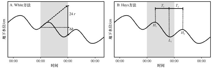
... 地下水位波动法(WTF)估算ET g .常用的White方法[23 ] 以及在其基础上改进的Hays方法[51 ] 等都属于地下水位波动法.White方法假设:①地下水位昼夜波动是植被蒸散发所致;②00:00—04:00的ET g 非常微弱(ET g =0),期间的地下水补给率可代表当日平均补给率;③含水层给水度可精确计算(Specific yield, S y )[52 ] .因此,E T g = S y ( 24 r + ∆ h ) r 为00:00—04::00的地下水补给率(mm·h-1 ),∆ h 图3 ).Hays方法将一天分为昼夜两个时段(T 1 、T 2 ),并假设T 2 时段(夜间)ET g 非常微弱(ET g =0)、地下水补给率与当日平均补给率相当[53 ] ,因此计算公式可改写为: ...
... 使用地下水位与土壤水分观测数据直接估算ET g 具有方法简单、结果直观的优势,因此应用非常广泛[51 ] .White方法是最早用于ET g 估算的地下水位波动法[23 ] ,但该方法成立需要满足部分假设条件,另外含水层给水度(S y )确定时的不确定性会影响结果的准确性.针对上述问题,Hays[51 ] 、Schilling[73 ] 对White方法进行了部分改进,但其适用场景和时间分辨率仍然非常有限.事实上,蒸散发不是引起地下水位或土壤水分波动的唯一原因,气压、温度、湿度,以及其他补给源的存在等都会导致地下水波动,White方法以及改进后的White方法在机制上都过于简单,所以都难以彻底克服实际应用过程中出现的不确定性[74 ] .在西北干旱区,由于地下水受灌溉抽取与回归水补给过程影响强烈,利用White方法获得的ET g 信息在数天到生长季的尺度上虽然可行,但在更小的时间尺度上却因为存在较大波动,无法准确反映ET g 的动态变化过程.近20年来,土壤水分自动观测手段逐渐成熟并普及,将土壤水分与地下水位数据结合成为ET g 估算的新思路,如Wang等[53 ] 根据土壤水分与地下水位波动之间的同步关系,提出了一种考虑毛细上升高度(Capillary fringe)的ET g 计算方法;Jia等[75 ] 提出利用真实土壤水分剖面与静水平衡状态的土壤水分剖面差进行ET g 估算的新方法.近年来,将饱和-非饱和土壤水运移模型与观测数据结合,开始成为ET g 估算的新趋势,如在土壤水分与地下水位数据基础上,利用具有严格物理机制的Richards方程,通过反解方法实现较高分辨率的ET g 估算[41 ] .但在如何克服土壤异质性、控制数据不确定性,以及降低计算复杂程度等方法仍然存在技术瓶颈,因此是未来利用数据驱动方法估算ET g 中需要重点克服的困难. ...
Estimation of groundwater consumption by phreatophytes using diurnal water table fluctuations: a saturated-unsaturated flow assessment
2
2005
... 地下水是维系干旱区生态功能的核心资源[1 ] .干旱区降水稀少、地表水匮乏,但地下水资源相对丰富[2 ] ;在浅埋条件下(埋深≤10 m),地下水与包气带土壤水联系紧密,并不同程度参与植被蒸散发过程,植被部分甚至完全依赖地下水生存[3 ] .地下水参与植被蒸散发的强度即为地下水蒸散发(Groundwater evapotranspiration,ET g ),包含通过地表土壤蒸发(E g )和植被蒸腾(T g )消耗的地下水量[4 -6 ] .ET g 是地下水浅埋环境中垂向水文循环的重要组分[7 ] ,是干旱区地下水最主要的自然排泄方式(>70%)[8 ] .ET g 的动态变化影响滨水系统(如河岸林、绿洲湿地等脆弱生态系统)水平衡动态[6 ,9 -10 ] 、土壤盐渍化过程[11 ] 、农田生产力的形成[12 ] ,以及固沙植被分布等[13 ] .所以,准确估算ET g 及其在实际蒸散发(Actual evapotranspiration, ET a )的占比对科学管理干旱区农业与水资源[14 -15 ] 、合理保护和修复地下水依赖型植被(Groundwater-dependent vegetations,GDV)意义重大[16 -18 ] .但是,ET g 受区域气候特征[19 -20 ] 、局地地下水波动规律[21 ] 、土地利用类型[14 ] 、土壤储水能力、植被根系分布等多种因素影响[22 -23 ] ,且与不同环境要素之间存在复杂的非线性关系,准确估算ET g 目前仍然是生态学与水文学中的难点[24 ] . ...
... 式中:H 1 、H 2 为相邻两天对应的地下水位峰值(mm);L 1 为期间的谷值;S y 为含水层给水度[24 ] .Hays方法根据地下水埋深变化过程线特征自然选择补给和耗散时段,更接近于真实情况,因此本文使用地下水位法中的Hays方法估算E T g . S y 采用“速效给水度”,即S y =(θ s -θ w )/2计算,θ s 为饱和土壤体积含水量,θ w 为凋萎系数(v/v)[54 ] . ...
Water resources of a part of Owens Valley,California
1
1912
... 针对ET g 的研究最早可以追溯到20世纪初,学者报道了美国犹他州北部ET g 与地下水位之间存在相关性[25 -26 ] ;Shaw等[27 ] 发现埋深<3 m时地下水参与沙壤土与壤土蒸发过程的强度(E g )相对显著;Gardner[28 ] 、Willis[29 ] 发现E g 与地下水位之间的函数关系很大程度上取决于土壤质地.近30年来出现了大量关于ET g 的观测与模拟研究工作,各种直接(如地下水蒸渗仪、根系液流等)[23 ,30 -32 ] 或间接观测手段(如基于水量平衡观测)日趋增多[33 -35 ] ,用于估算ET g 的方法(如各种经验关系甚至机制模型)不断出现[17 ,36 ] .但是,这些观测手段普遍费用较高[37 ] ,相关的估算方法也通常存在边界条件限制与参数不确定性问题[4 ,38 ] .大量研究表明,土壤水分与地下水位对地球关键带中发生的重要生态水文过程(如蒸散发、渗漏过程等)具有一定的记忆效应[39 -40 ] ,如何利用可以相对方便、大量获得的常规观测数据,通过数据驱动方法估算不便或不易直接观测的水文变量(如ET g )已经成为生态-水文学中的研究热点和全新方向[23 ,41 ] ,但在技术上仍存在挑战[38 ,42 ] . ...
Regional groundwater evapotranspiration in Illinois
2
2009
... 针对ET g 的研究最早可以追溯到20世纪初,学者报道了美国犹他州北部ET g 与地下水位之间存在相关性[25 -26 ] ;Shaw等[27 ] 发现埋深<3 m时地下水参与沙壤土与壤土蒸发过程的强度(E g )相对显著;Gardner[28 ] 、Willis[29 ] 发现E g 与地下水位之间的函数关系很大程度上取决于土壤质地.近30年来出现了大量关于ET g 的观测与模拟研究工作,各种直接(如地下水蒸渗仪、根系液流等)[23 ,30 -32 ] 或间接观测手段(如基于水量平衡观测)日趋增多[33 -35 ] ,用于估算ET g 的方法(如各种经验关系甚至机制模型)不断出现[17 ,36 ] .但是,这些观测手段普遍费用较高[37 ] ,相关的估算方法也通常存在边界条件限制与参数不确定性问题[4 ,38 ] .大量研究表明,土壤水分与地下水位对地球关键带中发生的重要生态水文过程(如蒸散发、渗漏过程等)具有一定的记忆效应[39 -40 ] ,如何利用可以相对方便、大量获得的常规观测数据,通过数据驱动方法估算不便或不易直接观测的水文变量(如ET g )已经成为生态-水文学中的研究热点和全新方向[23 ,41 ] ,但在技术上仍存在挑战[38 ,42 ] . ...
... 干旱半干旱区环境中,地下水系统受ET g 影响表现出明显的昼夜波动特征,基于地下水位的昼夜波动规律可实现ET g 的估算[23 ] .地下水位波动法(Water Table Fluctuation, WTF)所需的数据容易获取,且实现过程相对简单[5 ] ,是ET g 估算中出现最早、使用最广泛的方法[43 -47 ] .受地下水毛细上升补给和植物根系提水过程影响,土壤水分动态也表现出与地下水位相似的昼夜波动规律[26 ,48 -49 ] ,因此利用土壤水分观测数据,并借鉴地下水位波动法的思路可实现地下水浅埋环境ET a 的估算(即土壤水分波动法,Soil Moisture Fluctuation, SMF).结合WTF与SMF方法即可确定地下水参与蒸散发的大致比例.本文以河西走廊中段的荒漠绿洲过渡带的典型植被沙枣(Elaeagnus angustifolia )林为例,通过地下水位波动法与土壤水分波动法估算ET g 强度和比例,评估数据驱动方法在荒漠绿洲过渡带地下水浅埋环境ET g 量化评估中的可行性,结果将为该地区水量平衡分析与地下水依赖型植被保护提供科学依据. ...
Maximum height of capillary rise starting with a soil at capillary saturation
1
1927
... 针对ET g 的研究最早可以追溯到20世纪初,学者报道了美国犹他州北部ET g 与地下水位之间存在相关性[25 -26 ] ;Shaw等[27 ] 发现埋深<3 m时地下水参与沙壤土与壤土蒸发过程的强度(E g )相对显著;Gardner[28 ] 、Willis[29 ] 发现E g 与地下水位之间的函数关系很大程度上取决于土壤质地.近30年来出现了大量关于ET g 的观测与模拟研究工作,各种直接(如地下水蒸渗仪、根系液流等)[23 ,30 -32 ] 或间接观测手段(如基于水量平衡观测)日趋增多[33 -35 ] ,用于估算ET g 的方法(如各种经验关系甚至机制模型)不断出现[17 ,36 ] .但是,这些观测手段普遍费用较高[37 ] ,相关的估算方法也通常存在边界条件限制与参数不确定性问题[4 ,38 ] .大量研究表明,土壤水分与地下水位对地球关键带中发生的重要生态水文过程(如蒸散发、渗漏过程等)具有一定的记忆效应[39 -40 ] ,如何利用可以相对方便、大量获得的常规观测数据,通过数据驱动方法估算不便或不易直接观测的水文变量(如ET g )已经成为生态-水文学中的研究热点和全新方向[23 ,41 ] ,但在技术上仍存在挑战[38 ,42 ] . ...
Some steady-state solutions of the unsaturated moisture flow equation with application to evapotranspiration from a water table
1
1958
... 针对ET g 的研究最早可以追溯到20世纪初,学者报道了美国犹他州北部ET g 与地下水位之间存在相关性[25 -26 ] ;Shaw等[27 ] 发现埋深<3 m时地下水参与沙壤土与壤土蒸发过程的强度(E g )相对显著;Gardner[28 ] 、Willis[29 ] 发现E g 与地下水位之间的函数关系很大程度上取决于土壤质地.近30年来出现了大量关于ET g 的观测与模拟研究工作,各种直接(如地下水蒸渗仪、根系液流等)[23 ,30 -32 ] 或间接观测手段(如基于水量平衡观测)日趋增多[33 -35 ] ,用于估算ET g 的方法(如各种经验关系甚至机制模型)不断出现[17 ,36 ] .但是,这些观测手段普遍费用较高[37 ] ,相关的估算方法也通常存在边界条件限制与参数不确定性问题[4 ,38 ] .大量研究表明,土壤水分与地下水位对地球关键带中发生的重要生态水文过程(如蒸散发、渗漏过程等)具有一定的记忆效应[39 -40 ] ,如何利用可以相对方便、大量获得的常规观测数据,通过数据驱动方法估算不便或不易直接观测的水文变量(如ET g )已经成为生态-水文学中的研究热点和全新方向[23 ,41 ] ,但在技术上仍存在挑战[38 ,42 ] . ...
Evaporation from layered soils in the presence of a water tablel
1
1960
... 针对ET g 的研究最早可以追溯到20世纪初,学者报道了美国犹他州北部ET g 与地下水位之间存在相关性[25 -26 ] ;Shaw等[27 ] 发现埋深<3 m时地下水参与沙壤土与壤土蒸发过程的强度(E g )相对显著;Gardner[28 ] 、Willis[29 ] 发现E g 与地下水位之间的函数关系很大程度上取决于土壤质地.近30年来出现了大量关于ET g 的观测与模拟研究工作,各种直接(如地下水蒸渗仪、根系液流等)[23 ,30 -32 ] 或间接观测手段(如基于水量平衡观测)日趋增多[33 -35 ] ,用于估算ET g 的方法(如各种经验关系甚至机制模型)不断出现[17 ,36 ] .但是,这些观测手段普遍费用较高[37 ] ,相关的估算方法也通常存在边界条件限制与参数不确定性问题[4 ,38 ] .大量研究表明,土壤水分与地下水位对地球关键带中发生的重要生态水文过程(如蒸散发、渗漏过程等)具有一定的记忆效应[39 -40 ] ,如何利用可以相对方便、大量获得的常规观测数据,通过数据驱动方法估算不便或不易直接观测的水文变量(如ET g )已经成为生态-水文学中的研究热点和全新方向[23 ,41 ] ,但在技术上仍存在挑战[38 ,42 ] . ...
Evaluating eddy covariance cotton ET measurements in an advective environment with large weighing lysimeters
1
2009
... 针对ET g 的研究最早可以追溯到20世纪初,学者报道了美国犹他州北部ET g 与地下水位之间存在相关性[25 -26 ] ;Shaw等[27 ] 发现埋深<3 m时地下水参与沙壤土与壤土蒸发过程的强度(E g )相对显著;Gardner[28 ] 、Willis[29 ] 发现E g 与地下水位之间的函数关系很大程度上取决于土壤质地.近30年来出现了大量关于ET g 的观测与模拟研究工作,各种直接(如地下水蒸渗仪、根系液流等)[23 ,30 -32 ] 或间接观测手段(如基于水量平衡观测)日趋增多[33 -35 ] ,用于估算ET g 的方法(如各种经验关系甚至机制模型)不断出现[17 ,36 ] .但是,这些观测手段普遍费用较高[37 ] ,相关的估算方法也通常存在边界条件限制与参数不确定性问题[4 ,38 ] .大量研究表明,土壤水分与地下水位对地球关键带中发生的重要生态水文过程(如蒸散发、渗漏过程等)具有一定的记忆效应[39 -40 ] ,如何利用可以相对方便、大量获得的常规观测数据,通过数据驱动方法估算不便或不易直接观测的水文变量(如ET g )已经成为生态-水文学中的研究热点和全新方向[23 ,41 ] ,但在技术上仍存在挑战[38 ,42 ] . ...
Using stable oxygen isotopes to quantify the water source used for transpiration by native shrubs in the San Luis Valley,Colorado U.S.A
0
2004
Effect of groundwater level depth and irrigation amount on water fluxes at the groundwater table and water use of wheat
1
2012
... 针对ET g 的研究最早可以追溯到20世纪初,学者报道了美国犹他州北部ET g 与地下水位之间存在相关性[25 -26 ] ;Shaw等[27 ] 发现埋深<3 m时地下水参与沙壤土与壤土蒸发过程的强度(E g )相对显著;Gardner[28 ] 、Willis[29 ] 发现E g 与地下水位之间的函数关系很大程度上取决于土壤质地.近30年来出现了大量关于ET g 的观测与模拟研究工作,各种直接(如地下水蒸渗仪、根系液流等)[23 ,30 -32 ] 或间接观测手段(如基于水量平衡观测)日趋增多[33 -35 ] ,用于估算ET g 的方法(如各种经验关系甚至机制模型)不断出现[17 ,36 ] .但是,这些观测手段普遍费用较高[37 ] ,相关的估算方法也通常存在边界条件限制与参数不确定性问题[4 ,38 ] .大量研究表明,土壤水分与地下水位对地球关键带中发生的重要生态水文过程(如蒸散发、渗漏过程等)具有一定的记忆效应[39 -40 ] ,如何利用可以相对方便、大量获得的常规观测数据,通过数据驱动方法估算不便或不易直接观测的水文变量(如ET g )已经成为生态-水文学中的研究热点和全新方向[23 ,41 ] ,但在技术上仍存在挑战[38 ,42 ] . ...
Estimates of ground-water discharge as determined from measurements of evapotranspiration,ash meadows area,Nye County,Nevada
1
... 针对ET g 的研究最早可以追溯到20世纪初,学者报道了美国犹他州北部ET g 与地下水位之间存在相关性[25 -26 ] ;Shaw等[27 ] 发现埋深<3 m时地下水参与沙壤土与壤土蒸发过程的强度(E g )相对显著;Gardner[28 ] 、Willis[29 ] 发现E g 与地下水位之间的函数关系很大程度上取决于土壤质地.近30年来出现了大量关于ET g 的观测与模拟研究工作,各种直接(如地下水蒸渗仪、根系液流等)[23 ,30 -32 ] 或间接观测手段(如基于水量平衡观测)日趋增多[33 -35 ] ,用于估算ET g 的方法(如各种经验关系甚至机制模型)不断出现[17 ,36 ] .但是,这些观测手段普遍费用较高[37 ] ,相关的估算方法也通常存在边界条件限制与参数不确定性问题[4 ,38 ] .大量研究表明,土壤水分与地下水位对地球关键带中发生的重要生态水文过程(如蒸散发、渗漏过程等)具有一定的记忆效应[39 -40 ] ,如何利用可以相对方便、大量获得的常规观测数据,通过数据驱动方法估算不便或不易直接观测的水文变量(如ET g )已经成为生态-水文学中的研究热点和全新方向[23 ,41 ] ,但在技术上仍存在挑战[38 ,42 ] . ...
A remote sensing surface energy balance algorithm for land (SEBAL)
0
1998
Satellite-based energy balance for Mapping Evapotranspiration With Internalized Calibration (METRIC)-Model
1
2007
... 针对ET g 的研究最早可以追溯到20世纪初,学者报道了美国犹他州北部ET g 与地下水位之间存在相关性[25 -26 ] ;Shaw等[27 ] 发现埋深<3 m时地下水参与沙壤土与壤土蒸发过程的强度(E g )相对显著;Gardner[28 ] 、Willis[29 ] 发现E g 与地下水位之间的函数关系很大程度上取决于土壤质地.近30年来出现了大量关于ET g 的观测与模拟研究工作,各种直接(如地下水蒸渗仪、根系液流等)[23 ,30 -32 ] 或间接观测手段(如基于水量平衡观测)日趋增多[33 -35 ] ,用于估算ET g 的方法(如各种经验关系甚至机制模型)不断出现[17 ,36 ] .但是,这些观测手段普遍费用较高[37 ] ,相关的估算方法也通常存在边界条件限制与参数不确定性问题[4 ,38 ] .大量研究表明,土壤水分与地下水位对地球关键带中发生的重要生态水文过程(如蒸散发、渗漏过程等)具有一定的记忆效应[39 -40 ] ,如何利用可以相对方便、大量获得的常规观测数据,通过数据驱动方法估算不便或不易直接观测的水文变量(如ET g )已经成为生态-水文学中的研究热点和全新方向[23 ,41 ] ,但在技术上仍存在挑战[38 ,42 ] . ...
荒漠绿洲湿地水分来源及植物水分利用策略
1
2022
... 针对ET g 的研究最早可以追溯到20世纪初,学者报道了美国犹他州北部ET g 与地下水位之间存在相关性[25 -26 ] ;Shaw等[27 ] 发现埋深<3 m时地下水参与沙壤土与壤土蒸发过程的强度(E g )相对显著;Gardner[28 ] 、Willis[29 ] 发现E g 与地下水位之间的函数关系很大程度上取决于土壤质地.近30年来出现了大量关于ET g 的观测与模拟研究工作,各种直接(如地下水蒸渗仪、根系液流等)[23 ,30 -32 ] 或间接观测手段(如基于水量平衡观测)日趋增多[33 -35 ] ,用于估算ET g 的方法(如各种经验关系甚至机制模型)不断出现[17 ,36 ] .但是,这些观测手段普遍费用较高[37 ] ,相关的估算方法也通常存在边界条件限制与参数不确定性问题[4 ,38 ] .大量研究表明,土壤水分与地下水位对地球关键带中发生的重要生态水文过程(如蒸散发、渗漏过程等)具有一定的记忆效应[39 -40 ] ,如何利用可以相对方便、大量获得的常规观测数据,通过数据驱动方法估算不便或不易直接观测的水文变量(如ET g )已经成为生态-水文学中的研究热点和全新方向[23 ,41 ] ,但在技术上仍存在挑战[38 ,42 ] . ...
Soil water sensing for water balance,ET and WUE
1
2012
... 针对ET g 的研究最早可以追溯到20世纪初,学者报道了美国犹他州北部ET g 与地下水位之间存在相关性[25 -26 ] ;Shaw等[27 ] 发现埋深<3 m时地下水参与沙壤土与壤土蒸发过程的强度(E g )相对显著;Gardner[28 ] 、Willis[29 ] 发现E g 与地下水位之间的函数关系很大程度上取决于土壤质地.近30年来出现了大量关于ET g 的观测与模拟研究工作,各种直接(如地下水蒸渗仪、根系液流等)[23 ,30 -32 ] 或间接观测手段(如基于水量平衡观测)日趋增多[33 -35 ] ,用于估算ET g 的方法(如各种经验关系甚至机制模型)不断出现[17 ,36 ] .但是,这些观测手段普遍费用较高[37 ] ,相关的估算方法也通常存在边界条件限制与参数不确定性问题[4 ,38 ] .大量研究表明,土壤水分与地下水位对地球关键带中发生的重要生态水文过程(如蒸散发、渗漏过程等)具有一定的记忆效应[39 -40 ] ,如何利用可以相对方便、大量获得的常规观测数据,通过数据驱动方法估算不便或不易直接观测的水文变量(如ET g )已经成为生态-水文学中的研究热点和全新方向[23 ,41 ] ,但在技术上仍存在挑战[38 ,42 ] . ...
Estimating groundwater evapotranspiration from irrigated cropland incorporating root zone soil texture and moisture dynamics
2
2016
... 针对ET g 的研究最早可以追溯到20世纪初,学者报道了美国犹他州北部ET g 与地下水位之间存在相关性[25 -26 ] ;Shaw等[27 ] 发现埋深<3 m时地下水参与沙壤土与壤土蒸发过程的强度(E g )相对显著;Gardner[28 ] 、Willis[29 ] 发现E g 与地下水位之间的函数关系很大程度上取决于土壤质地.近30年来出现了大量关于ET g 的观测与模拟研究工作,各种直接(如地下水蒸渗仪、根系液流等)[23 ,30 -32 ] 或间接观测手段(如基于水量平衡观测)日趋增多[33 -35 ] ,用于估算ET g 的方法(如各种经验关系甚至机制模型)不断出现[17 ,36 ] .但是,这些观测手段普遍费用较高[37 ] ,相关的估算方法也通常存在边界条件限制与参数不确定性问题[4 ,38 ] .大量研究表明,土壤水分与地下水位对地球关键带中发生的重要生态水文过程(如蒸散发、渗漏过程等)具有一定的记忆效应[39 -40 ] ,如何利用可以相对方便、大量获得的常规观测数据,通过数据驱动方法估算不便或不易直接观测的水文变量(如ET g )已经成为生态-水文学中的研究热点和全新方向[23 ,41 ] ,但在技术上仍存在挑战[38 ,42 ] . ...
... [38 ,42 ]. ...
Inferring subsurface preferential flow features from a wavelet analysis of hydrological signals in the Shale Hills Catchment
1
2020
... 针对ET g 的研究最早可以追溯到20世纪初,学者报道了美国犹他州北部ET g 与地下水位之间存在相关性[25 -26 ] ;Shaw等[27 ] 发现埋深<3 m时地下水参与沙壤土与壤土蒸发过程的强度(E g )相对显著;Gardner[28 ] 、Willis[29 ] 发现E g 与地下水位之间的函数关系很大程度上取决于土壤质地.近30年来出现了大量关于ET g 的观测与模拟研究工作,各种直接(如地下水蒸渗仪、根系液流等)[23 ,30 -32 ] 或间接观测手段(如基于水量平衡观测)日趋增多[33 -35 ] ,用于估算ET g 的方法(如各种经验关系甚至机制模型)不断出现[17 ,36 ] .但是,这些观测手段普遍费用较高[37 ] ,相关的估算方法也通常存在边界条件限制与参数不确定性问题[4 ,38 ] .大量研究表明,土壤水分与地下水位对地球关键带中发生的重要生态水文过程(如蒸散发、渗漏过程等)具有一定的记忆效应[39 -40 ] ,如何利用可以相对方便、大量获得的常规观测数据,通过数据驱动方法估算不便或不易直接观测的水文变量(如ET g )已经成为生态-水文学中的研究热点和全新方向[23 ,41 ] ,但在技术上仍存在挑战[38 ,42 ] . ...
Groundwater influence on soil moisture memory and land-atmosphere fluxes in the Iberian Peninsula
1
2019
... 针对ET g 的研究最早可以追溯到20世纪初,学者报道了美国犹他州北部ET g 与地下水位之间存在相关性[25 -26 ] ;Shaw等[27 ] 发现埋深<3 m时地下水参与沙壤土与壤土蒸发过程的强度(E g )相对显著;Gardner[28 ] 、Willis[29 ] 发现E g 与地下水位之间的函数关系很大程度上取决于土壤质地.近30年来出现了大量关于ET g 的观测与模拟研究工作,各种直接(如地下水蒸渗仪、根系液流等)[23 ,30 -32 ] 或间接观测手段(如基于水量平衡观测)日趋增多[33 -35 ] ,用于估算ET g 的方法(如各种经验关系甚至机制模型)不断出现[17 ,36 ] .但是,这些观测手段普遍费用较高[37 ] ,相关的估算方法也通常存在边界条件限制与参数不确定性问题[4 ,38 ] .大量研究表明,土壤水分与地下水位对地球关键带中发生的重要生态水文过程(如蒸散发、渗漏过程等)具有一定的记忆效应[39 -40 ] ,如何利用可以相对方便、大量获得的常规观测数据,通过数据驱动方法估算不便或不易直接观测的水文变量(如ET g )已经成为生态-水文学中的研究热点和全新方向[23 ,41 ] ,但在技术上仍存在挑战[38 ,42 ] . ...
Quantification of soil water balance components based on continuous soil moisture measurement and Richards equation in an irrigated agricultural field of a desert oasis
3
2019
... 针对ET g 的研究最早可以追溯到20世纪初,学者报道了美国犹他州北部ET g 与地下水位之间存在相关性[25 -26 ] ;Shaw等[27 ] 发现埋深<3 m时地下水参与沙壤土与壤土蒸发过程的强度(E g )相对显著;Gardner[28 ] 、Willis[29 ] 发现E g 与地下水位之间的函数关系很大程度上取决于土壤质地.近30年来出现了大量关于ET g 的观测与模拟研究工作,各种直接(如地下水蒸渗仪、根系液流等)[23 ,30 -32 ] 或间接观测手段(如基于水量平衡观测)日趋增多[33 -35 ] ,用于估算ET g 的方法(如各种经验关系甚至机制模型)不断出现[17 ,36 ] .但是,这些观测手段普遍费用较高[37 ] ,相关的估算方法也通常存在边界条件限制与参数不确定性问题[4 ,38 ] .大量研究表明,土壤水分与地下水位对地球关键带中发生的重要生态水文过程(如蒸散发、渗漏过程等)具有一定的记忆效应[39 -40 ] ,如何利用可以相对方便、大量获得的常规观测数据,通过数据驱动方法估算不便或不易直接观测的水文变量(如ET g )已经成为生态-水文学中的研究热点和全新方向[23 ,41 ] ,但在技术上仍存在挑战[38 ,42 ] . ...
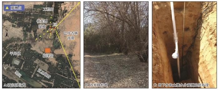
... 研究区为黑河中游荒漠绿洲交错带的锁龙潭湿地及其周边地区,总面积约21 km2 ,内有农田、湖泊、盐沼、沙丘等镶嵌分布的异质景观.锁龙潭湿地东侧为巴丹吉林沙漠(地下水位4—5 m),西北侧为新垦绿洲(地下水位1.5—3 m,开垦50年),西南侧为固定沙丘、农田防护林和部分新垦农田(地下水埋位小于3 m),黑河主河道位于研究区西南,距离锁龙潭湿地约5.2 km (图1 ).区域内年平均气温7.6 ℃,日气温高于10 ℃的年积温3 085 ℃,无霜期165 d,年降水量仅为116.8 mm,年蒸发量高达2 390 mm,大陆性干旱荒漠气候明显.年日照时长达3 045 h,太阳辐射总量为611 272.8 J·cm-2 ·a-1 .风沙活动集中于3—5月,年均风速3.2 m·s-1 ,风速>17 m·s-1 的大风天数年均15 d.区域内降水季节特征明显,夏季(7—9月)降水可占全年总量的65%,且发生频率较低;≤5 mm的小降水事件占全年总降水事件的56.1%、年降水量的46.7%(1967—2008年).区域内地貌类型以冲积扇平原和风成地貌为主,土壤类型有地带性的灰棕漠土以及非地带性的风沙土、草甸土、盐土、沼泽土、灌耕土等,质地较粗,有机质含量很低(<0.83%)[41 ] .区域内植被为中温带荒漠化草原植被,主要由超旱生灌木、半灌木或盐生、旱生肉质半灌木组成,菊科、藜科、蒺藜科、麻黄科、禾本科、豆科等植物较为常见. ...
... 使用地下水位与土壤水分观测数据直接估算ET g 具有方法简单、结果直观的优势,因此应用非常广泛[51 ] .White方法是最早用于ET g 估算的地下水位波动法[23 ] ,但该方法成立需要满足部分假设条件,另外含水层给水度(S y )确定时的不确定性会影响结果的准确性.针对上述问题,Hays[51 ] 、Schilling[73 ] 对White方法进行了部分改进,但其适用场景和时间分辨率仍然非常有限.事实上,蒸散发不是引起地下水位或土壤水分波动的唯一原因,气压、温度、湿度,以及其他补给源的存在等都会导致地下水波动,White方法以及改进后的White方法在机制上都过于简单,所以都难以彻底克服实际应用过程中出现的不确定性[74 ] .在西北干旱区,由于地下水受灌溉抽取与回归水补给过程影响强烈,利用White方法获得的ET g 信息在数天到生长季的尺度上虽然可行,但在更小的时间尺度上却因为存在较大波动,无法准确反映ET g 的动态变化过程.近20年来,土壤水分自动观测手段逐渐成熟并普及,将土壤水分与地下水位数据结合成为ET g 估算的新思路,如Wang等[53 ] 根据土壤水分与地下水位波动之间的同步关系,提出了一种考虑毛细上升高度(Capillary fringe)的ET g 计算方法;Jia等[75 ] 提出利用真实土壤水分剖面与静水平衡状态的土壤水分剖面差进行ET g 估算的新方法.近年来,将饱和-非饱和土壤水运移模型与观测数据结合,开始成为ET g 估算的新趋势,如在土壤水分与地下水位数据基础上,利用具有严格物理机制的Richards方程,通过反解方法实现较高分辨率的ET g 估算[41 ] .但在如何克服土壤异质性、控制数据不确定性,以及降低计算复杂程度等方法仍然存在技术瓶颈,因此是未来利用数据驱动方法估算ET g 中需要重点克服的困难. ...
Guidelines for Predicting Crop Water Requirements
1
1975
... 针对ET g 的研究最早可以追溯到20世纪初,学者报道了美国犹他州北部ET g 与地下水位之间存在相关性[25 -26 ] ;Shaw等[27 ] 发现埋深<3 m时地下水参与沙壤土与壤土蒸发过程的强度(E g )相对显著;Gardner[28 ] 、Willis[29 ] 发现E g 与地下水位之间的函数关系很大程度上取决于土壤质地.近30年来出现了大量关于ET g 的观测与模拟研究工作,各种直接(如地下水蒸渗仪、根系液流等)[23 ,30 -32 ] 或间接观测手段(如基于水量平衡观测)日趋增多[33 -35 ] ,用于估算ET g 的方法(如各种经验关系甚至机制模型)不断出现[17 ,36 ] .但是,这些观测手段普遍费用较高[37 ] ,相关的估算方法也通常存在边界条件限制与参数不确定性问题[4 ,38 ] .大量研究表明,土壤水分与地下水位对地球关键带中发生的重要生态水文过程(如蒸散发、渗漏过程等)具有一定的记忆效应[39 -40 ] ,如何利用可以相对方便、大量获得的常规观测数据,通过数据驱动方法估算不便或不易直接观测的水文变量(如ET g )已经成为生态-水文学中的研究热点和全新方向[23 ,41 ] ,但在技术上仍存在挑战[38 ,42 ] . ...
Estimation of grou-ndwater recharge by groundwater level fluctuation method of Dibdibba aquifer at ?Karbala-Najaf Plateau,central of Iraq
1
2018
... 干旱半干旱区环境中,地下水系统受ET g 影响表现出明显的昼夜波动特征,基于地下水位的昼夜波动规律可实现ET g 的估算[23 ] .地下水位波动法(Water Table Fluctuation, WTF)所需的数据容易获取,且实现过程相对简单[5 ] ,是ET g 估算中出现最早、使用最广泛的方法[43 -47 ] .受地下水毛细上升补给和植物根系提水过程影响,土壤水分动态也表现出与地下水位相似的昼夜波动规律[26 ,48 -49 ] ,因此利用土壤水分观测数据,并借鉴地下水位波动法的思路可实现地下水浅埋环境ET a 的估算(即土壤水分波动法,Soil Moisture Fluctuation, SMF).结合WTF与SMF方法即可确定地下水参与蒸散发的大致比例.本文以河西走廊中段的荒漠绿洲过渡带的典型植被沙枣(Elaeagnus angustifolia )林为例,通过地下水位波动法与土壤水分波动法估算ET g 强度和比例,评估数据驱动方法在荒漠绿洲过渡带地下水浅埋环境ET g 量化评估中的可行性,结果将为该地区水量平衡分析与地下水依赖型植被保护提供科学依据. ...
Estimating groundwater evapotranspiration by a subtropical pine plantation using diurnal water table fluctuations: implications from night-time water use
0
2016
Using groundwater levels to estimate recharge
0
2002
Estimating groundwater evapotranspiration rates using diurnal water-table fluctuations in a semi-arid riparian zone
0
2008
Monitoring and modeling water-vegetation interactions in groundwater-dependent ecosystems
1
2012
... 干旱半干旱区环境中,地下水系统受ET g 影响表现出明显的昼夜波动特征,基于地下水位的昼夜波动规律可实现ET g 的估算[23 ] .地下水位波动法(Water Table Fluctuation, WTF)所需的数据容易获取,且实现过程相对简单[5 ] ,是ET g 估算中出现最早、使用最广泛的方法[43 -47 ] .受地下水毛细上升补给和植物根系提水过程影响,土壤水分动态也表现出与地下水位相似的昼夜波动规律[26 ,48 -49 ] ,因此利用土壤水分观测数据,并借鉴地下水位波动法的思路可实现地下水浅埋环境ET a 的估算(即土壤水分波动法,Soil Moisture Fluctuation, SMF).结合WTF与SMF方法即可确定地下水参与蒸散发的大致比例.本文以河西走廊中段的荒漠绿洲过渡带的典型植被沙枣(Elaeagnus angustifolia )林为例,通过地下水位波动法与土壤水分波动法估算ET g 强度和比例,评估数据驱动方法在荒漠绿洲过渡带地下水浅埋环境ET g 量化评估中的可行性,结果将为该地区水量平衡分析与地下水依赖型植被保护提供科学依据. ...
Causes of diurnal fluctuations of tensiometers
1
1950
... 干旱半干旱区环境中,地下水系统受ET g 影响表现出明显的昼夜波动特征,基于地下水位的昼夜波动规律可实现ET g 的估算[23 ] .地下水位波动法(Water Table Fluctuation, WTF)所需的数据容易获取,且实现过程相对简单[5 ] ,是ET g 估算中出现最早、使用最广泛的方法[43 -47 ] .受地下水毛细上升补给和植物根系提水过程影响,土壤水分动态也表现出与地下水位相似的昼夜波动规律[26 ,48 -49 ] ,因此利用土壤水分观测数据,并借鉴地下水位波动法的思路可实现地下水浅埋环境ET a 的估算(即土壤水分波动法,Soil Moisture Fluctuation, SMF).结合WTF与SMF方法即可确定地下水参与蒸散发的大致比例.本文以河西走廊中段的荒漠绿洲过渡带的典型植被沙枣(Elaeagnus angustifolia )林为例,通过地下水位波动法与土壤水分波动法估算ET g 强度和比例,评估数据驱动方法在荒漠绿洲过渡带地下水浅埋环境ET g 量化评估中的可行性,结果将为该地区水量平衡分析与地下水依赖型植被保护提供科学依据. ...
Analytical expressions for transient specific yield and shallow water table drainage
1
2002
... 干旱半干旱区环境中,地下水系统受ET g 影响表现出明显的昼夜波动特征,基于地下水位的昼夜波动规律可实现ET g 的估算[23 ] .地下水位波动法(Water Table Fluctuation, WTF)所需的数据容易获取,且实现过程相对简单[5 ] ,是ET g 估算中出现最早、使用最广泛的方法[43 -47 ] .受地下水毛细上升补给和植物根系提水过程影响,土壤水分动态也表现出与地下水位相似的昼夜波动规律[26 ,48 -49 ] ,因此利用土壤水分观测数据,并借鉴地下水位波动法的思路可实现地下水浅埋环境ET a 的估算(即土壤水分波动法,Soil Moisture Fluctuation, SMF).结合WTF与SMF方法即可确定地下水参与蒸散发的大致比例.本文以河西走廊中段的荒漠绿洲过渡带的典型植被沙枣(Elaeagnus angustifolia )林为例,通过地下水位波动法与土壤水分波动法估算ET g 强度和比例,评估数据驱动方法在荒漠绿洲过渡带地下水浅埋环境ET g 量化评估中的可行性,结果将为该地区水量平衡分析与地下水依赖型植被保护提供科学依据. ...
基于Budyko水热耦合平衡假设的流域蒸散发研究
1
2007
... 沿锁龙潭湿地周边自然景观梯度布设了16个地下水观测井与土壤水分观测剖面,基本覆盖了湿生草甸、河岸林以及荒漠深根灌木等典型地下水依赖型植被类型,形成了地下水与土壤水分的高频自动观测站网,并自动收集地下水位、温度、盐分、土壤剖面水分、盐分等连续观测数据(图2 ).其中,土壤水分剖面采用TDR(Time domain reflectometry)土壤水分传感器观测(TRIMW-EZ,IMKO,德国,每10 min观测1次);地下水动态使用压力式地下水位传感器获得(HOBO,美国,每1 h观测1次).在传感器布设过程中同步用环刀(100 cm3 )分层取剖面原状土(采样深度:70、90、110、130、150、170、190、210、230、250 cm),分析其物理参数(容重、孔隙度、机械组成、田间持水量、饱和导水率、水分特征曲线、土壤给水度等)和化学参数(有机质、全氮、盐分含量及pH等),并记录植物主根深度、各级侧根数量、长度、深度分布范围及根直径.本文选取其中受农田灌溉影响较小的沙枣林样地,估算其生长季ET g ;所需逐时温度、降水、水面蒸发[ET pan ,E-601蒸发皿,用于反映大气蒸发潜力,与潜在蒸散发(Potential evapotranspiration, PET)[50 ] 高度线性相关]等气象数据由布设在中国生态系统研究网络临泽内陆河流域研究站站区的标准气象站观测获得. ...
Water Use by Saltcedar (Tamarix sp.) and Associated Vegetation on the Canadian,Colorado and Pecos Rivers in Texas
3
2003
... 地下水位波动法(WTF)估算ET g .常用的White方法[23 ] 以及在其基础上改进的Hays方法[51 ] 等都属于地下水位波动法.White方法假设:①地下水位昼夜波动是植被蒸散发所致;②00:00—04:00的ET g 非常微弱(ET g =0),期间的地下水补给率可代表当日平均补给率;③含水层给水度可精确计算(Specific yield, S y )[52 ] .因此,E T g = S y ( 24 r + ∆ h ) r 为00:00—04::00的地下水补给率(mm·h-1 ),∆ h 图3 ).Hays方法将一天分为昼夜两个时段(T 1 、T 2 ),并假设T 2 时段(夜间)ET g 非常微弱(ET g =0)、地下水补给率与当日平均补给率相当[53 ] ,因此计算公式可改写为: ...
... 使用地下水位与土壤水分观测数据直接估算ET g 具有方法简单、结果直观的优势,因此应用非常广泛[51 ] .White方法是最早用于ET g 估算的地下水位波动法[23 ] ,但该方法成立需要满足部分假设条件,另外含水层给水度(S y )确定时的不确定性会影响结果的准确性.针对上述问题,Hays[51 ] 、Schilling[73 ] 对White方法进行了部分改进,但其适用场景和时间分辨率仍然非常有限.事实上,蒸散发不是引起地下水位或土壤水分波动的唯一原因,气压、温度、湿度,以及其他补给源的存在等都会导致地下水波动,White方法以及改进后的White方法在机制上都过于简单,所以都难以彻底克服实际应用过程中出现的不确定性[74 ] .在西北干旱区,由于地下水受灌溉抽取与回归水补给过程影响强烈,利用White方法获得的ET g 信息在数天到生长季的尺度上虽然可行,但在更小的时间尺度上却因为存在较大波动,无法准确反映ET g 的动态变化过程.近20年来,土壤水分自动观测手段逐渐成熟并普及,将土壤水分与地下水位数据结合成为ET g 估算的新思路,如Wang等[53 ] 根据土壤水分与地下水位波动之间的同步关系,提出了一种考虑毛细上升高度(Capillary fringe)的ET g 计算方法;Jia等[75 ] 提出利用真实土壤水分剖面与静水平衡状态的土壤水分剖面差进行ET g 估算的新方法.近年来,将饱和-非饱和土壤水运移模型与观测数据结合,开始成为ET g 估算的新趋势,如在土壤水分与地下水位数据基础上,利用具有严格物理机制的Richards方程,通过反解方法实现较高分辨率的ET g 估算[41 ] .但在如何克服土壤异质性、控制数据不确定性,以及降低计算复杂程度等方法仍然存在技术瓶颈,因此是未来利用数据驱动方法估算ET g 中需要重点克服的困难. ...
... [51 ]、Schilling[73 ] 对White方法进行了部分改进,但其适用场景和时间分辨率仍然非常有限.事实上,蒸散发不是引起地下水位或土壤水分波动的唯一原因,气压、温度、湿度,以及其他补给源的存在等都会导致地下水波动,White方法以及改进后的White方法在机制上都过于简单,所以都难以彻底克服实际应用过程中出现的不确定性[74 ] .在西北干旱区,由于地下水受灌溉抽取与回归水补给过程影响强烈,利用White方法获得的ET g 信息在数天到生长季的尺度上虽然可行,但在更小的时间尺度上却因为存在较大波动,无法准确反映ET g 的动态变化过程.近20年来,土壤水分自动观测手段逐渐成熟并普及,将土壤水分与地下水位数据结合成为ET g 估算的新思路,如Wang等[53 ] 根据土壤水分与地下水位波动之间的同步关系,提出了一种考虑毛细上升高度(Capillary fringe)的ET g 计算方法;Jia等[75 ] 提出利用真实土壤水分剖面与静水平衡状态的土壤水分剖面差进行ET g 估算的新方法.近年来,将饱和-非饱和土壤水运移模型与观测数据结合,开始成为ET g 估算的新趋势,如在土壤水分与地下水位数据基础上,利用具有严格物理机制的Richards方程,通过反解方法实现较高分辨率的ET g 估算[41 ] .但在如何克服土壤异质性、控制数据不确定性,以及降低计算复杂程度等方法仍然存在技术瓶颈,因此是未来利用数据驱动方法估算ET g 中需要重点克服的困难. ...
估算干旱区地下水依赖型植物蒸散发的White法评述
1
2018
... 地下水位波动法(WTF)估算ET g .常用的White方法[23 ] 以及在其基础上改进的Hays方法[51 ] 等都属于地下水位波动法.White方法假设:①地下水位昼夜波动是植被蒸散发所致;②00:00—04:00的ET g 非常微弱(ET g =0),期间的地下水补给率可代表当日平均补给率;③含水层给水度可精确计算(Specific yield, S y )[52 ] .因此,E T g = S y ( 24 r + ∆ h ) r 为00:00—04::00的地下水补给率(mm·h-1 ),∆ h 图3 ).Hays方法将一天分为昼夜两个时段(T 1 、T 2 ),并假设T 2 时段(夜间)ET g 非常微弱(ET g =0)、地下水补给率与当日平均补给率相当[53 ] ,因此计算公式可改写为: ...
Estimating groundwater evapotranspiration by phreatophytes using combined water level and soil moisture observations
2
2019
... 地下水位波动法(WTF)估算ET g .常用的White方法[23 ] 以及在其基础上改进的Hays方法[51 ] 等都属于地下水位波动法.White方法假设:①地下水位昼夜波动是植被蒸散发所致;②00:00—04:00的ET g 非常微弱(ET g =0),期间的地下水补给率可代表当日平均补给率;③含水层给水度可精确计算(Specific yield, S y )[52 ] .因此,E T g = S y ( 24 r + ∆ h ) r 为00:00—04::00的地下水补给率(mm·h-1 ),∆ h 图3 ).Hays方法将一天分为昼夜两个时段(T 1 、T 2 ),并假设T 2 时段(夜间)ET g 非常微弱(ET g =0)、地下水补给率与当日平均补给率相当[53 ] ,因此计算公式可改写为: ...
... 使用地下水位与土壤水分观测数据直接估算ET g 具有方法简单、结果直观的优势,因此应用非常广泛[51 ] .White方法是最早用于ET g 估算的地下水位波动法[23 ] ,但该方法成立需要满足部分假设条件,另外含水层给水度(S y )确定时的不确定性会影响结果的准确性.针对上述问题,Hays[51 ] 、Schilling[73 ] 对White方法进行了部分改进,但其适用场景和时间分辨率仍然非常有限.事实上,蒸散发不是引起地下水位或土壤水分波动的唯一原因,气压、温度、湿度,以及其他补给源的存在等都会导致地下水波动,White方法以及改进后的White方法在机制上都过于简单,所以都难以彻底克服实际应用过程中出现的不确定性[74 ] .在西北干旱区,由于地下水受灌溉抽取与回归水补给过程影响强烈,利用White方法获得的ET g 信息在数天到生长季的尺度上虽然可行,但在更小的时间尺度上却因为存在较大波动,无法准确反映ET g 的动态变化过程.近20年来,土壤水分自动观测手段逐渐成熟并普及,将土壤水分与地下水位数据结合成为ET g 估算的新思路,如Wang等[53 ] 根据土壤水分与地下水位波动之间的同步关系,提出了一种考虑毛细上升高度(Capillary fringe)的ET g 计算方法;Jia等[75 ] 提出利用真实土壤水分剖面与静水平衡状态的土壤水分剖面差进行ET g 估算的新方法.近年来,将饱和-非饱和土壤水运移模型与观测数据结合,开始成为ET g 估算的新趋势,如在土壤水分与地下水位数据基础上,利用具有严格物理机制的Richards方程,通过反解方法实现较高分辨率的ET g 估算[41 ] .但在如何克服土壤异质性、控制数据不确定性,以及降低计算复杂程度等方法仍然存在技术瓶颈,因此是未来利用数据驱动方法估算ET g 中需要重点克服的困难. ...
Three observations on streamflow depletion by phreatophytes
1
1965
... 式中:H 1 、H 2 为相邻两天对应的地下水位峰值(mm);L 1 为期间的谷值;S y 为含水层给水度[24 ] .Hays方法根据地下水埋深变化过程线特征自然选择补给和耗散时段,更接近于真实情况,因此本文使用地下水位法中的Hays方法估算E T g . S y 采用“速效给水度”,即S y =(θ s -θ w )/2计算,θ s 为饱和土壤体积含水量,θ w 为凋萎系数(v/v)[54 ] . ...
Evapotranspiration of two vegetation covers in a shallow water table environment
3
2005
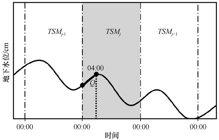
... 土壤水分波动法(SMF)估算ET a .本文使用由Nachabe等[55 ] 提出的ET a 估算方案(图4 ),该方法将00:00—04:00土壤剖面水分的总量(Total soil moisture, TSM)变化值作为当日土壤水的侧向补给率(Q ),当日ET a 则可通过观测地下水位以上土壤剖面总水分的日变化来估算: ...
... [
55 ])
Schematic diagram of <i>ET</i><sub>a</sub> estimation by soil moisture fluctuation method (Modified from Nachabe <i>et al</i>.<sup>[<xref ref-type="bibr" rid="R55">55</xref>]</sup>) Fig. 4 ![]()
Q = T S M 04 : 00 - T S M 00 : 00 4 (2) E T a = T S M j - T S M j + 1 + 24 × Q (3) 式中:Q 为地下水侧向补给量(cm);TSMj 为第j 天午夜的土壤总水分(cm),TSMj+ 1 为24 h后的土壤总水分(即第二天午夜,cm),TSM 04:00 和TSM 00:00 分别为04:00和00:00的土壤剖面总水分(cm). ...
... [
55 ])
Fig. 4 ![]()
Q = T S M 04 : 00 - T S M 00 : 00 4 (2) E T a = T S M j - T S M j + 1 + 24 × Q (3) 式中:Q 为地下水侧向补给量(cm);TSMj 为第j 天午夜的土壤总水分(cm),TSMj+ 1 为24 h后的土壤总水分(即第二天午夜,cm),TSM 04:00 和TSM 00:00 分别为04:00和00:00的土壤剖面总水分(cm). ...
Root distribution of three co-occurring desert shrubs and their physiological response to precipitation
1
2009
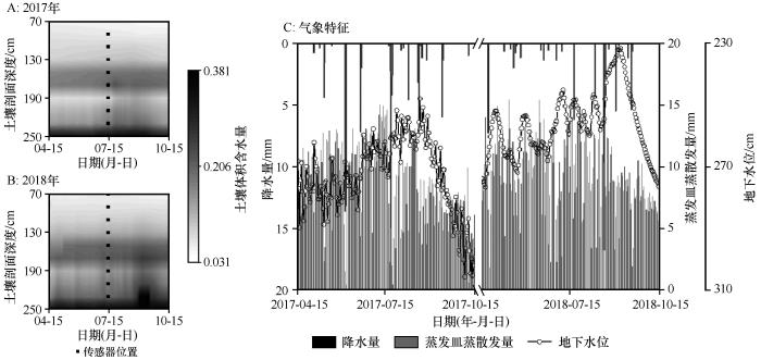
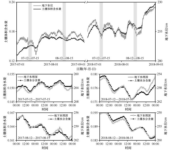
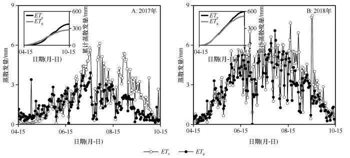
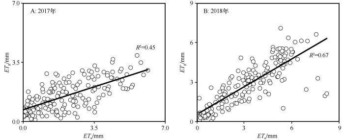
... 地下水浅埋环境中,地下水参与植被蒸散发过程的强度日间较高,但夜间明显减弱甚至完全停止;该过程不仅体现在地下水位的昼夜波动上,也反映在土壤水分剖面的昼夜波动中(图5 ).由于研究区地处农业绿洲边缘,受生长季农田漫灌与地下水抽取过程影响,地下水位季节波动也非常明显,毛细上升区土壤水分含量大,与地下水位负相关,地下水系统与土壤剖面之间的水分交换强烈;相关程度在地下水位较小的2018年强于2017年,生长季整体上高于非生长季(图6 ),强烈的植物根系提水作用通常是发生该现象的重要原因[56 ] ,因此是地下水参与植被蒸散发的关键证据[57 -58 ] .干旱环境中植物对地下水的利用能达到蒸腾量的50%,旱季甚至能达到80%[59 ] ,本文沙枣林处地下水对蒸散发的贡献率大于70%,主要原因是研究区位于巴丹吉林沙漠边缘,生长季蒸散发潜力巨大(ET pan =1 686.1 mm),但可有效补给土壤水分的降水事件(>2 mm)却很少,加上样地位于锁龙潭湿地周边(100 m),地下水位较浅(<3.0 m)且水源供给充分,导致生长季蒸散发量(2017年ET a =375 mm;2018年ET a =589 mm)与地下水参与蒸散发(2017年ET g =275 mm;2018年ET g =511 mm)年际差异明显,地下水位和土壤水分储量波动影响是造成该现象的主要原因.植物对地下水的利用涉及两种机制:①通过毛细上升供给根际层水分;②根系进入地下水或毛细水边界获得水分[60 ] .前一种情况下的关键变量是地下水位、蒸散发、根际层水势等,但多数土壤在>2 m的垂向空间上不存在有意义的毛细水流[60 ] ;后一种情况下,植物根系实际长度可能远大于传统意义上的根际层深度并触及地下水,水分提升取决于深层根系的汲水能力、根系分布特征等生理参数[61 -62 ] .沙枣是干旱区常见的物种,针对其根系特征与水源识别方面的研究结果表明沙枣根系发达且主根粗长[63 ] ,由于本文研究区地下水埋深较浅,沙枣对地下水的利用机制很可能同时涉及两类地下水利用机制. ...
Application of the water table fluctuation method for estimating evapotranspiration at two phreatophyte-dominated sites under hyper-arid environments
1
2014
... 地下水浅埋环境中,地下水参与植被蒸散发过程的强度日间较高,但夜间明显减弱甚至完全停止;该过程不仅体现在地下水位的昼夜波动上,也反映在土壤水分剖面的昼夜波动中(图5 ).由于研究区地处农业绿洲边缘,受生长季农田漫灌与地下水抽取过程影响,地下水位季节波动也非常明显,毛细上升区土壤水分含量大,与地下水位负相关,地下水系统与土壤剖面之间的水分交换强烈;相关程度在地下水位较小的2018年强于2017年,生长季整体上高于非生长季(图6 ),强烈的植物根系提水作用通常是发生该现象的重要原因[56 ] ,因此是地下水参与植被蒸散发的关键证据[57 -58 ] .干旱环境中植物对地下水的利用能达到蒸腾量的50%,旱季甚至能达到80%[59 ] ,本文沙枣林处地下水对蒸散发的贡献率大于70%,主要原因是研究区位于巴丹吉林沙漠边缘,生长季蒸散发潜力巨大(ET pan =1 686.1 mm),但可有效补给土壤水分的降水事件(>2 mm)却很少,加上样地位于锁龙潭湿地周边(100 m),地下水位较浅(<3.0 m)且水源供给充分,导致生长季蒸散发量(2017年ET a =375 mm;2018年ET a =589 mm)与地下水参与蒸散发(2017年ET g =275 mm;2018年ET g =511 mm)年际差异明显,地下水位和土壤水分储量波动影响是造成该现象的主要原因.植物对地下水的利用涉及两种机制:①通过毛细上升供给根际层水分;②根系进入地下水或毛细水边界获得水分[60 ] .前一种情况下的关键变量是地下水位、蒸散发、根际层水势等,但多数土壤在>2 m的垂向空间上不存在有意义的毛细水流[60 ] ;后一种情况下,植物根系实际长度可能远大于传统意义上的根际层深度并触及地下水,水分提升取决于深层根系的汲水能力、根系分布特征等生理参数[61 -62 ] .沙枣是干旱区常见的物种,针对其根系特征与水源识别方面的研究结果表明沙枣根系发达且主根粗长[63 ] ,由于本文研究区地下水埋深较浅,沙枣对地下水的利用机制很可能同时涉及两类地下水利用机制. ...
植物-土壤系统中水分再分配作用研究进展
1
2006
... 地下水浅埋环境中,地下水参与植被蒸散发过程的强度日间较高,但夜间明显减弱甚至完全停止;该过程不仅体现在地下水位的昼夜波动上,也反映在土壤水分剖面的昼夜波动中(图5 ).由于研究区地处农业绿洲边缘,受生长季农田漫灌与地下水抽取过程影响,地下水位季节波动也非常明显,毛细上升区土壤水分含量大,与地下水位负相关,地下水系统与土壤剖面之间的水分交换强烈;相关程度在地下水位较小的2018年强于2017年,生长季整体上高于非生长季(图6 ),强烈的植物根系提水作用通常是发生该现象的重要原因[56 ] ,因此是地下水参与植被蒸散发的关键证据[57 -58 ] .干旱环境中植物对地下水的利用能达到蒸腾量的50%,旱季甚至能达到80%[59 ] ,本文沙枣林处地下水对蒸散发的贡献率大于70%,主要原因是研究区位于巴丹吉林沙漠边缘,生长季蒸散发潜力巨大(ET pan =1 686.1 mm),但可有效补给土壤水分的降水事件(>2 mm)却很少,加上样地位于锁龙潭湿地周边(100 m),地下水位较浅(<3.0 m)且水源供给充分,导致生长季蒸散发量(2017年ET a =375 mm;2018年ET a =589 mm)与地下水参与蒸散发(2017年ET g =275 mm;2018年ET g =511 mm)年际差异明显,地下水位和土壤水分储量波动影响是造成该现象的主要原因.植物对地下水的利用涉及两种机制:①通过毛细上升供给根际层水分;②根系进入地下水或毛细水边界获得水分[60 ] .前一种情况下的关键变量是地下水位、蒸散发、根际层水势等,但多数土壤在>2 m的垂向空间上不存在有意义的毛细水流[60 ] ;后一种情况下,植物根系实际长度可能远大于传统意义上的根际层深度并触及地下水,水分提升取决于深层根系的汲水能力、根系分布特征等生理参数[61 -62 ] .沙枣是干旱区常见的物种,针对其根系特征与水源识别方面的研究结果表明沙枣根系发达且主根粗长[63 ] ,由于本文研究区地下水埋深较浅,沙枣对地下水的利用机制很可能同时涉及两类地下水利用机制. ...
Groundwater uptake by woody vegetation in a semiarid oak savanna
1
2010
... 地下水浅埋环境中,地下水参与植被蒸散发过程的强度日间较高,但夜间明显减弱甚至完全停止;该过程不仅体现在地下水位的昼夜波动上,也反映在土壤水分剖面的昼夜波动中(图5 ).由于研究区地处农业绿洲边缘,受生长季农田漫灌与地下水抽取过程影响,地下水位季节波动也非常明显,毛细上升区土壤水分含量大,与地下水位负相关,地下水系统与土壤剖面之间的水分交换强烈;相关程度在地下水位较小的2018年强于2017年,生长季整体上高于非生长季(图6 ),强烈的植物根系提水作用通常是发生该现象的重要原因[56 ] ,因此是地下水参与植被蒸散发的关键证据[57 -58 ] .干旱环境中植物对地下水的利用能达到蒸腾量的50%,旱季甚至能达到80%[59 ] ,本文沙枣林处地下水对蒸散发的贡献率大于70%,主要原因是研究区位于巴丹吉林沙漠边缘,生长季蒸散发潜力巨大(ET pan =1 686.1 mm),但可有效补给土壤水分的降水事件(>2 mm)却很少,加上样地位于锁龙潭湿地周边(100 m),地下水位较浅(<3.0 m)且水源供给充分,导致生长季蒸散发量(2017年ET a =375 mm;2018年ET a =589 mm)与地下水参与蒸散发(2017年ET g =275 mm;2018年ET g =511 mm)年际差异明显,地下水位和土壤水分储量波动影响是造成该现象的主要原因.植物对地下水的利用涉及两种机制:①通过毛细上升供给根际层水分;②根系进入地下水或毛细水边界获得水分[60 ] .前一种情况下的关键变量是地下水位、蒸散发、根际层水势等,但多数土壤在>2 m的垂向空间上不存在有意义的毛细水流[60 ] ;后一种情况下,植物根系实际长度可能远大于传统意义上的根际层深度并触及地下水,水分提升取决于深层根系的汲水能力、根系分布特征等生理参数[61 -62 ] .沙枣是干旱区常见的物种,针对其根系特征与水源识别方面的研究结果表明沙枣根系发达且主根粗长[63 ] ,由于本文研究区地下水埋深较浅,沙枣对地下水的利用机制很可能同时涉及两类地下水利用机制. ...
Simulating the effect of capillary flux on the soil water balance in a stochastic ecohydrological framework
2
... 地下水浅埋环境中,地下水参与植被蒸散发过程的强度日间较高,但夜间明显减弱甚至完全停止;该过程不仅体现在地下水位的昼夜波动上,也反映在土壤水分剖面的昼夜波动中(图5 ).由于研究区地处农业绿洲边缘,受生长季农田漫灌与地下水抽取过程影响,地下水位季节波动也非常明显,毛细上升区土壤水分含量大,与地下水位负相关,地下水系统与土壤剖面之间的水分交换强烈;相关程度在地下水位较小的2018年强于2017年,生长季整体上高于非生长季(图6 ),强烈的植物根系提水作用通常是发生该现象的重要原因[56 ] ,因此是地下水参与植被蒸散发的关键证据[57 -58 ] .干旱环境中植物对地下水的利用能达到蒸腾量的50%,旱季甚至能达到80%[59 ] ,本文沙枣林处地下水对蒸散发的贡献率大于70%,主要原因是研究区位于巴丹吉林沙漠边缘,生长季蒸散发潜力巨大(ET pan =1 686.1 mm),但可有效补给土壤水分的降水事件(>2 mm)却很少,加上样地位于锁龙潭湿地周边(100 m),地下水位较浅(<3.0 m)且水源供给充分,导致生长季蒸散发量(2017年ET a =375 mm;2018年ET a =589 mm)与地下水参与蒸散发(2017年ET g =275 mm;2018年ET g =511 mm)年际差异明显,地下水位和土壤水分储量波动影响是造成该现象的主要原因.植物对地下水的利用涉及两种机制:①通过毛细上升供给根际层水分;②根系进入地下水或毛细水边界获得水分[60 ] .前一种情况下的关键变量是地下水位、蒸散发、根际层水势等,但多数土壤在>2 m的垂向空间上不存在有意义的毛细水流[60 ] ;后一种情况下,植物根系实际长度可能远大于传统意义上的根际层深度并触及地下水,水分提升取决于深层根系的汲水能力、根系分布特征等生理参数[61 -62 ] .沙枣是干旱区常见的物种,针对其根系特征与水源识别方面的研究结果表明沙枣根系发达且主根粗长[63 ] ,由于本文研究区地下水埋深较浅,沙枣对地下水的利用机制很可能同时涉及两类地下水利用机制. ...
... [60 ];后一种情况下,植物根系实际长度可能远大于传统意义上的根际层深度并触及地下水,水分提升取决于深层根系的汲水能力、根系分布特征等生理参数[61 -62 ] .沙枣是干旱区常见的物种,针对其根系特征与水源识别方面的研究结果表明沙枣根系发达且主根粗长[63 ] ,由于本文研究区地下水埋深较浅,沙枣对地下水的利用机制很可能同时涉及两类地下水利用机制. ...
Soil moisture spatial variability: inter-and intra-annual dynamics
1
... 地下水浅埋环境中,地下水参与植被蒸散发过程的强度日间较高,但夜间明显减弱甚至完全停止;该过程不仅体现在地下水位的昼夜波动上,也反映在土壤水分剖面的昼夜波动中(图5 ).由于研究区地处农业绿洲边缘,受生长季农田漫灌与地下水抽取过程影响,地下水位季节波动也非常明显,毛细上升区土壤水分含量大,与地下水位负相关,地下水系统与土壤剖面之间的水分交换强烈;相关程度在地下水位较小的2018年强于2017年,生长季整体上高于非生长季(图6 ),强烈的植物根系提水作用通常是发生该现象的重要原因[56 ] ,因此是地下水参与植被蒸散发的关键证据[57 -58 ] .干旱环境中植物对地下水的利用能达到蒸腾量的50%,旱季甚至能达到80%[59 ] ,本文沙枣林处地下水对蒸散发的贡献率大于70%,主要原因是研究区位于巴丹吉林沙漠边缘,生长季蒸散发潜力巨大(ET pan =1 686.1 mm),但可有效补给土壤水分的降水事件(>2 mm)却很少,加上样地位于锁龙潭湿地周边(100 m),地下水位较浅(<3.0 m)且水源供给充分,导致生长季蒸散发量(2017年ET a =375 mm;2018年ET a =589 mm)与地下水参与蒸散发(2017年ET g =275 mm;2018年ET g =511 mm)年际差异明显,地下水位和土壤水分储量波动影响是造成该现象的主要原因.植物对地下水的利用涉及两种机制:①通过毛细上升供给根际层水分;②根系进入地下水或毛细水边界获得水分[60 ] .前一种情况下的关键变量是地下水位、蒸散发、根际层水势等,但多数土壤在>2 m的垂向空间上不存在有意义的毛细水流[60 ] ;后一种情况下,植物根系实际长度可能远大于传统意义上的根际层深度并触及地下水,水分提升取决于深层根系的汲水能力、根系分布特征等生理参数[61 -62 ] .沙枣是干旱区常见的物种,针对其根系特征与水源识别方面的研究结果表明沙枣根系发达且主根粗长[63 ] ,由于本文研究区地下水埋深较浅,沙枣对地下水的利用机制很可能同时涉及两类地下水利用机制. ...
Soil-moisture limits on plant uptake: an upscaled relationship for water-limited ecosystems
1
2005
... 地下水浅埋环境中,地下水参与植被蒸散发过程的强度日间较高,但夜间明显减弱甚至完全停止;该过程不仅体现在地下水位的昼夜波动上,也反映在土壤水分剖面的昼夜波动中(图5 ).由于研究区地处农业绿洲边缘,受生长季农田漫灌与地下水抽取过程影响,地下水位季节波动也非常明显,毛细上升区土壤水分含量大,与地下水位负相关,地下水系统与土壤剖面之间的水分交换强烈;相关程度在地下水位较小的2018年强于2017年,生长季整体上高于非生长季(图6 ),强烈的植物根系提水作用通常是发生该现象的重要原因[56 ] ,因此是地下水参与植被蒸散发的关键证据[57 -58 ] .干旱环境中植物对地下水的利用能达到蒸腾量的50%,旱季甚至能达到80%[59 ] ,本文沙枣林处地下水对蒸散发的贡献率大于70%,主要原因是研究区位于巴丹吉林沙漠边缘,生长季蒸散发潜力巨大(ET pan =1 686.1 mm),但可有效补给土壤水分的降水事件(>2 mm)却很少,加上样地位于锁龙潭湿地周边(100 m),地下水位较浅(<3.0 m)且水源供给充分,导致生长季蒸散发量(2017年ET a =375 mm;2018年ET a =589 mm)与地下水参与蒸散发(2017年ET g =275 mm;2018年ET g =511 mm)年际差异明显,地下水位和土壤水分储量波动影响是造成该现象的主要原因.植物对地下水的利用涉及两种机制:①通过毛细上升供给根际层水分;②根系进入地下水或毛细水边界获得水分[60 ] .前一种情况下的关键变量是地下水位、蒸散发、根际层水势等,但多数土壤在>2 m的垂向空间上不存在有意义的毛细水流[60 ] ;后一种情况下,植物根系实际长度可能远大于传统意义上的根际层深度并触及地下水,水分提升取决于深层根系的汲水能力、根系分布特征等生理参数[61 -62 ] .沙枣是干旱区常见的物种,针对其根系特征与水源识别方面的研究结果表明沙枣根系发达且主根粗长[63 ] ,由于本文研究区地下水埋深较浅,沙枣对地下水的利用机制很可能同时涉及两类地下水利用机制. ...
极度干旱区不同灌水量下沙枣防护林根系分布特征
1
2012
... 地下水浅埋环境中,地下水参与植被蒸散发过程的强度日间较高,但夜间明显减弱甚至完全停止;该过程不仅体现在地下水位的昼夜波动上,也反映在土壤水分剖面的昼夜波动中(图5 ).由于研究区地处农业绿洲边缘,受生长季农田漫灌与地下水抽取过程影响,地下水位季节波动也非常明显,毛细上升区土壤水分含量大,与地下水位负相关,地下水系统与土壤剖面之间的水分交换强烈;相关程度在地下水位较小的2018年强于2017年,生长季整体上高于非生长季(图6 ),强烈的植物根系提水作用通常是发生该现象的重要原因[56 ] ,因此是地下水参与植被蒸散发的关键证据[57 -58 ] .干旱环境中植物对地下水的利用能达到蒸腾量的50%,旱季甚至能达到80%[59 ] ,本文沙枣林处地下水对蒸散发的贡献率大于70%,主要原因是研究区位于巴丹吉林沙漠边缘,生长季蒸散发潜力巨大(ET pan =1 686.1 mm),但可有效补给土壤水分的降水事件(>2 mm)却很少,加上样地位于锁龙潭湿地周边(100 m),地下水位较浅(<3.0 m)且水源供给充分,导致生长季蒸散发量(2017年ET a =375 mm;2018年ET a =589 mm)与地下水参与蒸散发(2017年ET g =275 mm;2018年ET g =511 mm)年际差异明显,地下水位和土壤水分储量波动影响是造成该现象的主要原因.植物对地下水的利用涉及两种机制:①通过毛细上升供给根际层水分;②根系进入地下水或毛细水边界获得水分[60 ] .前一种情况下的关键变量是地下水位、蒸散发、根际层水势等,但多数土壤在>2 m的垂向空间上不存在有意义的毛细水流[60 ] ;后一种情况下,植物根系实际长度可能远大于传统意义上的根际层深度并触及地下水,水分提升取决于深层根系的汲水能力、根系分布特征等生理参数[61 -62 ] .沙枣是干旱区常见的物种,针对其根系特征与水源识别方面的研究结果表明沙枣根系发达且主根粗长[63 ] ,由于本文研究区地下水埋深较浅,沙枣对地下水的利用机制很可能同时涉及两类地下水利用机制. ...
The impact of groundwater depth on the spatial variance of vegetation index in the Ordos Plateau,China: a semivariogram analysis
1
2020
... 干旱半干旱环境中,地下水系统与植被过程之间存在着复杂的关联关系[13 ] .植被对地下水响应的深度通常小于10 m[64 ] ,在影响范围内,植被对地下水的响应特征受多种环境因子影响[65 ] ,如蒸散发强度随埋深增加呈反‘S’形下降,但拐点却随土壤水力参数、地下水养分/盐分含量变化[66 -68 ] ;地下水参与不同植被蒸散发(ET g )也会因为地上/地下生物量的分配格局[69 ] 及其用水策略存在较大差异[6 ,70 -72 ] .地下水位较浅且植被、土壤和水文条件一致的情况下,ET g 与大气蒸发高度相关;随着埋深增加,土壤输水能力成为影响ET g 的主要因素[18 ] .针对沙枣林样地的回归分析表明,潜在蒸散发、土壤储水量、地下水位与ET g 存在显著正相关关系.潜在蒸散发体现了植被需水的程度,而前期土壤储水量反映了土壤自身的水分供给能力,二者直接决定了植被对地下水的依赖程度;地下水位则代表了植被对地下水资源获取的难易程度.潜在蒸散发、土壤储水量、地下水位对ET g 变化方差的贡献率在2017年和2018年依次分别为48%、21%、31%和24%、24%、52%,该比例可能随样地生态-水文条件发生较大变化.植被本身对水分的利用规律也是影响ET g 的重要原因,但沙枣作为干旱区典型植物,生理过程对水分资源的需求均趋于保守,既保持较低的碳同化速率、同时维持较低的水分需求,以确保水分供给不受或少受环境胁迫的影响.本文获得的生长季ET a 、ET g 均较大,主要原因可能是样地中水分供给条件优越,导致土壤蒸发过程强烈,因此植物蒸腾所占实际蒸散发的比例可能相对较低,但受本文研究方法和研究数据的限制,尚无法确定准确的比例关系;此外,本研究缺少生长季内详细的植被参数和地下水养分/盐分等信息,且地下水波动范围相对较窄,尚无法建立更完整的ET g 对重要环境变量的响应关系. ...
Study on capillary rise from shallow groundwater and critical water table depth of a saline-sodic soil in western Songnen plain of China
1
2011
... 干旱半干旱环境中,地下水系统与植被过程之间存在着复杂的关联关系[13 ] .植被对地下水响应的深度通常小于10 m[64 ] ,在影响范围内,植被对地下水的响应特征受多种环境因子影响[65 ] ,如蒸散发强度随埋深增加呈反‘S’形下降,但拐点却随土壤水力参数、地下水养分/盐分含量变化[66 -68 ] ;地下水参与不同植被蒸散发(ET g )也会因为地上/地下生物量的分配格局[69 ] 及其用水策略存在较大差异[6 ,70 -72 ] .地下水位较浅且植被、土壤和水文条件一致的情况下,ET g 与大气蒸发高度相关;随着埋深增加,土壤输水能力成为影响ET g 的主要因素[18 ] .针对沙枣林样地的回归分析表明,潜在蒸散发、土壤储水量、地下水位与ET g 存在显著正相关关系.潜在蒸散发体现了植被需水的程度,而前期土壤储水量反映了土壤自身的水分供给能力,二者直接决定了植被对地下水的依赖程度;地下水位则代表了植被对地下水资源获取的难易程度.潜在蒸散发、土壤储水量、地下水位对ET g 变化方差的贡献率在2017年和2018年依次分别为48%、21%、31%和24%、24%、52%,该比例可能随样地生态-水文条件发生较大变化.植被本身对水分的利用规律也是影响ET g 的重要原因,但沙枣作为干旱区典型植物,生理过程对水分资源的需求均趋于保守,既保持较低的碳同化速率、同时维持较低的水分需求,以确保水分供给不受或少受环境胁迫的影响.本文获得的生长季ET a 、ET g 均较大,主要原因可能是样地中水分供给条件优越,导致土壤蒸发过程强烈,因此植物蒸腾所占实际蒸散发的比例可能相对较低,但受本文研究方法和研究数据的限制,尚无法确定准确的比例关系;此外,本研究缺少生长季内详细的植被参数和地下水养分/盐分等信息,且地下水波动范围相对较窄,尚无法建立更完整的ET g 对重要环境变量的响应关系. ...
How water use of Salix psammophila bush depends on groundwater depth in a semi-desert area
1
2016
... 干旱半干旱环境中,地下水系统与植被过程之间存在着复杂的关联关系[13 ] .植被对地下水响应的深度通常小于10 m[64 ] ,在影响范围内,植被对地下水的响应特征受多种环境因子影响[65 ] ,如蒸散发强度随埋深增加呈反‘S’形下降,但拐点却随土壤水力参数、地下水养分/盐分含量变化[66 -68 ] ;地下水参与不同植被蒸散发(ET g )也会因为地上/地下生物量的分配格局[69 ] 及其用水策略存在较大差异[6 ,70 -72 ] .地下水位较浅且植被、土壤和水文条件一致的情况下,ET g 与大气蒸发高度相关;随着埋深增加,土壤输水能力成为影响ET g 的主要因素[18 ] .针对沙枣林样地的回归分析表明,潜在蒸散发、土壤储水量、地下水位与ET g 存在显著正相关关系.潜在蒸散发体现了植被需水的程度,而前期土壤储水量反映了土壤自身的水分供给能力,二者直接决定了植被对地下水的依赖程度;地下水位则代表了植被对地下水资源获取的难易程度.潜在蒸散发、土壤储水量、地下水位对ET g 变化方差的贡献率在2017年和2018年依次分别为48%、21%、31%和24%、24%、52%,该比例可能随样地生态-水文条件发生较大变化.植被本身对水分的利用规律也是影响ET g 的重要原因,但沙枣作为干旱区典型植物,生理过程对水分资源的需求均趋于保守,既保持较低的碳同化速率、同时维持较低的水分需求,以确保水分供给不受或少受环境胁迫的影响.本文获得的生长季ET a 、ET g 均较大,主要原因可能是样地中水分供给条件优越,导致土壤蒸发过程强烈,因此植物蒸腾所占实际蒸散发的比例可能相对较低,但受本文研究方法和研究数据的限制,尚无法确定准确的比例关系;此外,本研究缺少生长季内详细的植被参数和地下水养分/盐分等信息,且地下水波动范围相对较窄,尚无法建立更完整的ET g 对重要环境变量的响应关系. ...
Distribution patterns of groundwater-dependent vegetation species diversity and their relationship to groundwater attributes in northwestern China
0
2013
Evidence for sensitivity of dune wetlands to groundwater nutrients
1
2014
... 干旱半干旱环境中,地下水系统与植被过程之间存在着复杂的关联关系[13 ] .植被对地下水响应的深度通常小于10 m[64 ] ,在影响范围内,植被对地下水的响应特征受多种环境因子影响[65 ] ,如蒸散发强度随埋深增加呈反‘S’形下降,但拐点却随土壤水力参数、地下水养分/盐分含量变化[66 -68 ] ;地下水参与不同植被蒸散发(ET g )也会因为地上/地下生物量的分配格局[69 ] 及其用水策略存在较大差异[6 ,70 -72 ] .地下水位较浅且植被、土壤和水文条件一致的情况下,ET g 与大气蒸发高度相关;随着埋深增加,土壤输水能力成为影响ET g 的主要因素[18 ] .针对沙枣林样地的回归分析表明,潜在蒸散发、土壤储水量、地下水位与ET g 存在显著正相关关系.潜在蒸散发体现了植被需水的程度,而前期土壤储水量反映了土壤自身的水分供给能力,二者直接决定了植被对地下水的依赖程度;地下水位则代表了植被对地下水资源获取的难易程度.潜在蒸散发、土壤储水量、地下水位对ET g 变化方差的贡献率在2017年和2018年依次分别为48%、21%、31%和24%、24%、52%,该比例可能随样地生态-水文条件发生较大变化.植被本身对水分的利用规律也是影响ET g 的重要原因,但沙枣作为干旱区典型植物,生理过程对水分资源的需求均趋于保守,既保持较低的碳同化速率、同时维持较低的水分需求,以确保水分供给不受或少受环境胁迫的影响.本文获得的生长季ET a 、ET g 均较大,主要原因可能是样地中水分供给条件优越,导致土壤蒸发过程强烈,因此植物蒸腾所占实际蒸散发的比例可能相对较低,但受本文研究方法和研究数据的限制,尚无法确定准确的比例关系;此外,本研究缺少生长季内详细的植被参数和地下水养分/盐分等信息,且地下水波动范围相对较窄,尚无法建立更完整的ET g 对重要环境变量的响应关系. ...
塔里木河下游荒漠河岸林地下水蒸散发
1
2020
... 干旱半干旱环境中,地下水系统与植被过程之间存在着复杂的关联关系[13 ] .植被对地下水响应的深度通常小于10 m[64 ] ,在影响范围内,植被对地下水的响应特征受多种环境因子影响[65 ] ,如蒸散发强度随埋深增加呈反‘S’形下降,但拐点却随土壤水力参数、地下水养分/盐分含量变化[66 -68 ] ;地下水参与不同植被蒸散发(ET g )也会因为地上/地下生物量的分配格局[69 ] 及其用水策略存在较大差异[6 ,70 -72 ] .地下水位较浅且植被、土壤和水文条件一致的情况下,ET g 与大气蒸发高度相关;随着埋深增加,土壤输水能力成为影响ET g 的主要因素[18 ] .针对沙枣林样地的回归分析表明,潜在蒸散发、土壤储水量、地下水位与ET g 存在显著正相关关系.潜在蒸散发体现了植被需水的程度,而前期土壤储水量反映了土壤自身的水分供给能力,二者直接决定了植被对地下水的依赖程度;地下水位则代表了植被对地下水资源获取的难易程度.潜在蒸散发、土壤储水量、地下水位对ET g 变化方差的贡献率在2017年和2018年依次分别为48%、21%、31%和24%、24%、52%,该比例可能随样地生态-水文条件发生较大变化.植被本身对水分的利用规律也是影响ET g 的重要原因,但沙枣作为干旱区典型植物,生理过程对水分资源的需求均趋于保守,既保持较低的碳同化速率、同时维持较低的水分需求,以确保水分供给不受或少受环境胁迫的影响.本文获得的生长季ET a 、ET g 均较大,主要原因可能是样地中水分供给条件优越,导致土壤蒸发过程强烈,因此植物蒸腾所占实际蒸散发的比例可能相对较低,但受本文研究方法和研究数据的限制,尚无法确定准确的比例关系;此外,本研究缺少生长季内详细的植被参数和地下水养分/盐分等信息,且地下水波动范围相对较窄,尚无法建立更完整的ET g 对重要环境变量的响应关系. ...
Quantifying the impact of groundwater depth on evapotranspiration in a semi-arid grassland region
1
2010
... 干旱半干旱环境中,地下水系统与植被过程之间存在着复杂的关联关系[13 ] .植被对地下水响应的深度通常小于10 m[64 ] ,在影响范围内,植被对地下水的响应特征受多种环境因子影响[65 ] ,如蒸散发强度随埋深增加呈反‘S’形下降,但拐点却随土壤水力参数、地下水养分/盐分含量变化[66 -68 ] ;地下水参与不同植被蒸散发(ET g )也会因为地上/地下生物量的分配格局[69 ] 及其用水策略存在较大差异[6 ,70 -72 ] .地下水位较浅且植被、土壤和水文条件一致的情况下,ET g 与大气蒸发高度相关;随着埋深增加,土壤输水能力成为影响ET g 的主要因素[18 ] .针对沙枣林样地的回归分析表明,潜在蒸散发、土壤储水量、地下水位与ET g 存在显著正相关关系.潜在蒸散发体现了植被需水的程度,而前期土壤储水量反映了土壤自身的水分供给能力,二者直接决定了植被对地下水的依赖程度;地下水位则代表了植被对地下水资源获取的难易程度.潜在蒸散发、土壤储水量、地下水位对ET g 变化方差的贡献率在2017年和2018年依次分别为48%、21%、31%和24%、24%、52%,该比例可能随样地生态-水文条件发生较大变化.植被本身对水分的利用规律也是影响ET g 的重要原因,但沙枣作为干旱区典型植物,生理过程对水分资源的需求均趋于保守,既保持较低的碳同化速率、同时维持较低的水分需求,以确保水分供给不受或少受环境胁迫的影响.本文获得的生长季ET a 、ET g 均较大,主要原因可能是样地中水分供给条件优越,导致土壤蒸发过程强烈,因此植物蒸腾所占实际蒸散发的比例可能相对较低,但受本文研究方法和研究数据的限制,尚无法确定准确的比例关系;此外,本研究缺少生长季内详细的植被参数和地下水养分/盐分等信息,且地下水波动范围相对较窄,尚无法建立更完整的ET g 对重要环境变量的响应关系. ...
Simulation of Populus euphratica root uptake of groundwater in an arid woodland of the Ejina Basin,China
0
2010
Seasonal variation in water uptake patterns of three plant species based on stable isotopes in the semi-arid Loess Plateau
1
2017
... 干旱半干旱环境中,地下水系统与植被过程之间存在着复杂的关联关系[13 ] .植被对地下水响应的深度通常小于10 m[64 ] ,在影响范围内,植被对地下水的响应特征受多种环境因子影响[65 ] ,如蒸散发强度随埋深增加呈反‘S’形下降,但拐点却随土壤水力参数、地下水养分/盐分含量变化[66 -68 ] ;地下水参与不同植被蒸散发(ET g )也会因为地上/地下生物量的分配格局[69 ] 及其用水策略存在较大差异[6 ,70 -72 ] .地下水位较浅且植被、土壤和水文条件一致的情况下,ET g 与大气蒸发高度相关;随着埋深增加,土壤输水能力成为影响ET g 的主要因素[18 ] .针对沙枣林样地的回归分析表明,潜在蒸散发、土壤储水量、地下水位与ET g 存在显著正相关关系.潜在蒸散发体现了植被需水的程度,而前期土壤储水量反映了土壤自身的水分供给能力,二者直接决定了植被对地下水的依赖程度;地下水位则代表了植被对地下水资源获取的难易程度.潜在蒸散发、土壤储水量、地下水位对ET g 变化方差的贡献率在2017年和2018年依次分别为48%、21%、31%和24%、24%、52%,该比例可能随样地生态-水文条件发生较大变化.植被本身对水分的利用规律也是影响ET g 的重要原因,但沙枣作为干旱区典型植物,生理过程对水分资源的需求均趋于保守,既保持较低的碳同化速率、同时维持较低的水分需求,以确保水分供给不受或少受环境胁迫的影响.本文获得的生长季ET a 、ET g 均较大,主要原因可能是样地中水分供给条件优越,导致土壤蒸发过程强烈,因此植物蒸腾所占实际蒸散发的比例可能相对较低,但受本文研究方法和研究数据的限制,尚无法确定准确的比例关系;此外,本研究缺少生长季内详细的植被参数和地下水养分/盐分等信息,且地下水波动范围相对较窄,尚无法建立更完整的ET g 对重要环境变量的响应关系. ...
Water table fluctuations under three riparian land covers,Iowa (USA)
1
2007
... 使用地下水位与土壤水分观测数据直接估算ET g 具有方法简单、结果直观的优势,因此应用非常广泛[51 ] .White方法是最早用于ET g 估算的地下水位波动法[23 ] ,但该方法成立需要满足部分假设条件,另外含水层给水度(S y )确定时的不确定性会影响结果的准确性.针对上述问题,Hays[51 ] 、Schilling[73 ] 对White方法进行了部分改进,但其适用场景和时间分辨率仍然非常有限.事实上,蒸散发不是引起地下水位或土壤水分波动的唯一原因,气压、温度、湿度,以及其他补给源的存在等都会导致地下水波动,White方法以及改进后的White方法在机制上都过于简单,所以都难以彻底克服实际应用过程中出现的不确定性[74 ] .在西北干旱区,由于地下水受灌溉抽取与回归水补给过程影响强烈,利用White方法获得的ET g 信息在数天到生长季的尺度上虽然可行,但在更小的时间尺度上却因为存在较大波动,无法准确反映ET g 的动态变化过程.近20年来,土壤水分自动观测手段逐渐成熟并普及,将土壤水分与地下水位数据结合成为ET g 估算的新思路,如Wang等[53 ] 根据土壤水分与地下水位波动之间的同步关系,提出了一种考虑毛细上升高度(Capillary fringe)的ET g 计算方法;Jia等[75 ] 提出利用真实土壤水分剖面与静水平衡状态的土壤水分剖面差进行ET g 估算的新方法.近年来,将饱和-非饱和土壤水运移模型与观测数据结合,开始成为ET g 估算的新趋势,如在土壤水分与地下水位数据基础上,利用具有严格物理机制的Richards方程,通过反解方法实现较高分辨率的ET g 估算[41 ] .但在如何克服土壤异质性、控制数据不确定性,以及降低计算复杂程度等方法仍然存在技术瓶颈,因此是未来利用数据驱动方法估算ET g 中需要重点克服的困难. ...
Groundwater studies in the Assiniboine River Drainage Basin,part I,evaluation of a flow system in south-central Saskatchewan
1
1966
... 使用地下水位与土壤水分观测数据直接估算ET g 具有方法简单、结果直观的优势,因此应用非常广泛[51 ] .White方法是最早用于ET g 估算的地下水位波动法[23 ] ,但该方法成立需要满足部分假设条件,另外含水层给水度(S y )确定时的不确定性会影响结果的准确性.针对上述问题,Hays[51 ] 、Schilling[73 ] 对White方法进行了部分改进,但其适用场景和时间分辨率仍然非常有限.事实上,蒸散发不是引起地下水位或土壤水分波动的唯一原因,气压、温度、湿度,以及其他补给源的存在等都会导致地下水波动,White方法以及改进后的White方法在机制上都过于简单,所以都难以彻底克服实际应用过程中出现的不确定性[74 ] .在西北干旱区,由于地下水受灌溉抽取与回归水补给过程影响强烈,利用White方法获得的ET g 信息在数天到生长季的尺度上虽然可行,但在更小的时间尺度上却因为存在较大波动,无法准确反映ET g 的动态变化过程.近20年来,土壤水分自动观测手段逐渐成熟并普及,将土壤水分与地下水位数据结合成为ET g 估算的新思路,如Wang等[53 ] 根据土壤水分与地下水位波动之间的同步关系,提出了一种考虑毛细上升高度(Capillary fringe)的ET g 计算方法;Jia等[75 ] 提出利用真实土壤水分剖面与静水平衡状态的土壤水分剖面差进行ET g 估算的新方法.近年来,将饱和-非饱和土壤水运移模型与观测数据结合,开始成为ET g 估算的新趋势,如在土壤水分与地下水位数据基础上,利用具有严格物理机制的Richards方程,通过反解方法实现较高分辨率的ET g 估算[41 ] .但在如何克服土壤异质性、控制数据不确定性,以及降低计算复杂程度等方法仍然存在技术瓶颈,因此是未来利用数据驱动方法估算ET g 中需要重点克服的困难. ...
Modified method for the estimation of groundwater evapotranspiration under very shallow water table conditions based on diurnal water table fluctuations
1
2021
... 使用地下水位与土壤水分观测数据直接估算ET g 具有方法简单、结果直观的优势,因此应用非常广泛[51 ] .White方法是最早用于ET g 估算的地下水位波动法[23 ] ,但该方法成立需要满足部分假设条件,另外含水层给水度(S y )确定时的不确定性会影响结果的准确性.针对上述问题,Hays[51 ] 、Schilling[73 ] 对White方法进行了部分改进,但其适用场景和时间分辨率仍然非常有限.事实上,蒸散发不是引起地下水位或土壤水分波动的唯一原因,气压、温度、湿度,以及其他补给源的存在等都会导致地下水波动,White方法以及改进后的White方法在机制上都过于简单,所以都难以彻底克服实际应用过程中出现的不确定性[74 ] .在西北干旱区,由于地下水受灌溉抽取与回归水补给过程影响强烈,利用White方法获得的ET g 信息在数天到生长季的尺度上虽然可行,但在更小的时间尺度上却因为存在较大波动,无法准确反映ET g 的动态变化过程.近20年来,土壤水分自动观测手段逐渐成熟并普及,将土壤水分与地下水位数据结合成为ET g 估算的新思路,如Wang等[53 ] 根据土壤水分与地下水位波动之间的同步关系,提出了一种考虑毛细上升高度(Capillary fringe)的ET g 计算方法;Jia等[75 ] 提出利用真实土壤水分剖面与静水平衡状态的土壤水分剖面差进行ET g 估算的新方法.近年来,将饱和-非饱和土壤水运移模型与观测数据结合,开始成为ET g 估算的新趋势,如在土壤水分与地下水位数据基础上,利用具有严格物理机制的Richards方程,通过反解方法实现较高分辨率的ET g 估算[41 ] .但在如何克服土壤异质性、控制数据不确定性,以及降低计算复杂程度等方法仍然存在技术瓶颈,因此是未来利用数据驱动方法估算ET g 中需要重点克服的困难. ...


 甘公网安备 62010202000688号