| 1 |
延芳芳.陆地生态系统碳通量观测方法的研究进展[J].科技促进发展,2012():158-159.
|
| 2 |
赵丽芳,沈占锋,李春明,等.地表净辐射通量观测、模拟和同化的研究进展[J].遥感学报,2019,23(1):24-36.
|
| 3 |
陈征,胡德勇,蒋卫国,等.基于GLASS数据估算中国陆表净辐射及其空间分布分析[J].地理研究,2016,35(1):25-36.
|
| 4 |
Malek E.Evaluation of effective atmospheric emissivity and parameterization of cloud at local scale[J].Atmospheric Research,1997,45(1):41-54.
|
| 5 |
Paltridge G W,Platt M R.Radiative process in meteorology and climatology[J].Social Studies of Science,2010,40(1):41-70.
|
| 6 |
高扬子,何洪林,张黎,等.近50年中国地表净辐射的时空变化特征分析[J].地球信息科学学报,2013,15(1):1-10.
|
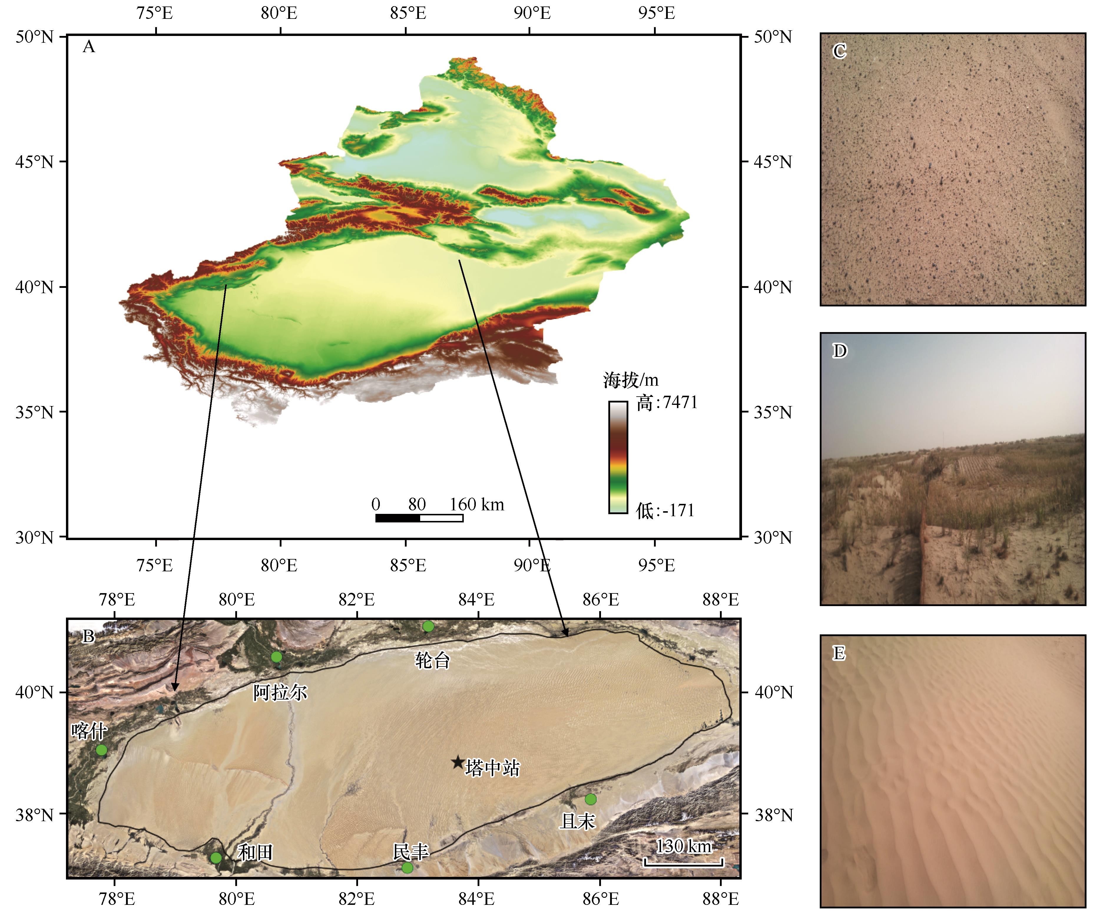
| 7 |
彭丽春,李万彪,叶晶,等.地表向下短波和长波辐射遥感参数化方案研究综述[J].北京大学学报(自然科学版),2015,51(4):772-782.
|
| 8 |
Li Z,Zhao L,Fu Z.Estimating net radiation flux in the Tibetan Plateau by assimilating MODIS LST products with an ensemble Kalman filter and particle filter[J].International Journal of Applied Earth Observations and Geoinformation,2012,19:1-11.
|
| 9 |
Silva B,Montenegro S,Silva V,et al.Determination of instantaneous and daily net radiation from TM-Landsat 5 data in a subtropical watershed[J].Journal of Atmospheric and Solar-Terrestrial Physics,2015,135:42-49.
|
| 10 |
Wang W,Liang S.Estimation of high-spatial resolution clear-sky longwave downward and net radiation over land surfaces from MODIS data[J].Remote Sensing of Environment,2009,113(4):745-754.
|
| 11 |
吴晓.从FY-4静止气象卫星估算晴空地表下行长波辐射通量的反演模式[J].气候与环境研究,2014,19(3):362-370.
|
| 12 |
Wang D,Liang S,He T,et al.Estimating clear-sky all-wave net radiation from combined visible and shortwave infrared (VSWIR) and thermal infrared (TIR) remote sensing data[J].Remote Sensing of Environment,2015,167:31-39.
|
| 13 |
叶晶,刘辉志,李万彪,等.利用MODIS数据直接估算晴空区干旱与半干旱地表净辐射通量[J].北京大学学报(自然科学版),2010,46(6):942-950.
|
| 14 |
Jia A,Liang S,Jiang B,et al.Comprehensive assessment of global surface net radiation products and uncertainty analysis[J].Journal of Geophysical Research Atmospheres,2018,123(4):1970-1989.
|
| 15 |
Carmona F,Rivas R,Caselles V,et al.Development of a general model to estimate the instantaneous,daily,and daytime net radiation with satellite data on clear-sky days[J].Remote Sensing of Environment,2015,17:11-13.
|
| 16 |
Amatya P M,Ma Y,Han C,et al.Estimation of net radiation flux distribution on the southern slopes of the central Himalayas using MODIS data[J].Atmospheric Research,2015,154:146-154.
|
| 17 |
Hurtado E,Sobrino J A.Daily net radiation estimated from air temperature and NOAA-AVHRR data:a case study for the Iberian Peninsula[J].International Journal of Remote Sensing,2010,22(8):1521-1533.
|
| 18 |
金莉莉,何清,买买提艾力·买买提依明,等.塔克拉玛干沙漠腹地辐射平衡和反照率变化特征[J].中国沙漠,2014,34(1):215-224.
|
| 19 |
李帅,胡列群,何清,等.塔克拉玛干沙漠腹地地表辐射收支特征研究[J].中国沙漠,2012,32(4):1035-1044.
|
| 20 |
杨帆,王顺胜,何清,等.塔克拉玛干沙漠腹地地表辐射与能量平衡[J].中国沙漠,2016,36(5):1408-1418.
|
| 21 |
买买提艾力·买买提依明,金莉莉,李振杰,等.2007—2011年塔克拉玛干沙漠腹地太阳辐射观测研究[J].气候变化研究进展,2014,10(2):87-94.
|
| 22 |
赵佳伟,何清,金莉莉,等.塔克拉玛干沙漠腹地秋季陆面过程特征[J].中国沙漠,2019,39(4):159-167.
|
| 23 |
周洒洒,何清,金莉莉,等.塔克拉玛干沙漠北缘绿洲-荒漠过渡带辐射特征:以肖塘为例[J].中国沙漠,2020,40(4):43-51.
|
| 24 |
金莉莉,李振杰,何清,等.CoLM模式对塔克拉玛干沙漠北缘陆面过程模拟评估及修正[J].中国沙漠,2018,38(6):1287-1302.
|
| 25 |
刘永强,艾力·买买提明,何清.对陆面过程模型CoLM中关键参数的修正[J].干旱区研究,2014,31(4):611-618.
|
| 26 |
李火青,买买提艾力·买买提依明,刘永强,等.陆面模型Noah-MP的不同参数化方案在沙漠区域的适用性研究[J].沙漠与绿洲气象,2018,12(6):58-67.
|
| 27 |
孟露,赵天良,杨兴华,等.塔克拉玛干沙漠腹地大气边界层参数化方案的模拟评估[J].气象科学,2018,38(2):157-166.
|
| 28 |
齐斐斐,刘永强,杨帆,等.SEBS模型在塔克拉玛干沙漠地区地表能量通量估算中的应用[J].干旱区资源与环境,2019,33(7):130-135.
|
| 29 |
齐斐斐,买买提艾力·买买提依明,霍文,等.塔克拉玛干沙漠腹地地表辐射和能量平衡及小气候特征[J].干旱气象,2020,38(1):32-39.
|
| 30 |
占车生,宁理科,邹靖,等.陆面水文-气候耦合模拟研究进展[J].地理学报,2018,73(5):893-905.
|
| 31 |
阿依尼格尔·亚力坤,买买提艾力·买买提依明,刘素红,等.新疆沙漠地区地表宽波段比辐射率遥感估算[J].地球信息科学学报,2020,22(8):1743-1751.
|
| 32 |
赵静学,郭枝虾,和鑫磊,等.黑河流域气温和降水再分析数据的不确定性评估[J].干旱气象,2019,37(4):529-539.
|
| 33 |
Idso S B,Jackson R D.Thermal radiation from the atmosphere[J].Journal of Geophysical Research,1969,74(23):5397-5403.
|
| 34 |
阿依尼格尔·亚力坤.塔克拉玛干沙漠地表特征参数及能量通量的遥感反演研究[D].乌鲁木齐:新疆大学,2020.
|
| 35 |
Offerle B,Grimmond C S B,Oke T R.Parameterization of net all-wave radiation for urban areas[J].Journal of Applied Meteorology,2003,42(8):1157-1173.
|
| 36 |
李火青,吴新萍,买买提艾力·买买提依明,等.利用FTIR和MODIS数据估算塔克拉玛干沙漠宽波段地表比辐射率[J].光谱学与光谱分析,2016,36(8):2414-2419.
|
| 37 |
Qian T,Dai A,Trenberth K E,et al.Simulation of global land surface conditions from 1948 to 2004.part I:forcing data and evaluations[J].Journal of Hydrometeorology,2006,7(5):953-975.
|
| 38 |
Pan X,Li X,Yang K,et al.Comparison of downscaled precipitation data over a mountainous watershed:a case study in the Heihe River Basin[J].Journal of Hydrometeorology,2014,15(4):1560-1574.
|
| 39 |
陆风,张晓虎,陈博洋,等.风云四号气象卫星成像特性及其应用前景[J].海洋气象学报,2017,37(2):1-12.
|
 ), 吴新萍2, 刘永强1(
 甘公网安备 62010202000688号