| 1 |
Metternicht G I, Zinck J A.Remote sensing of soil salinity:potentials and constraints[J].Remote Sensing of Environment,2003,85(1):1-20.
|
| 2 |
Gorji T, Sertel E, Tanik A.Monitoring soil salinity via remote sensing technology under data scarce conditions:a case study from Turkey[J].Ecological Indicators,2017,74:384-391.
|
| 3 |
丁建丽,姚远,王飞.干旱区土壤盐渍化特征空间建模[J].生态学报,2014,34(16):4620-4631.
|
| 4 |
Mougenot B, Pouget M, Epema G.Remote sensing of salt-affected soils[J].Remote Sensing Reviews,1993,7(3/4):241-259.
|
| 5 |
张飞,塔西甫拉提·特依拜,丁建丽,等.渭干河-库车河三角洲绿洲土壤盐渍化现状特征及其与光谱的关系[J].环境科学研究,2009,22(2):227-235.
|
| 6 |
翁永玲,戚浩平,方洪宾,等.基于PLSR方法的青海茶卡-共和盆地土壤盐分高光谱遥感反演[J].土壤学报,2010,47(6):1255-1263.
|
| 7 |
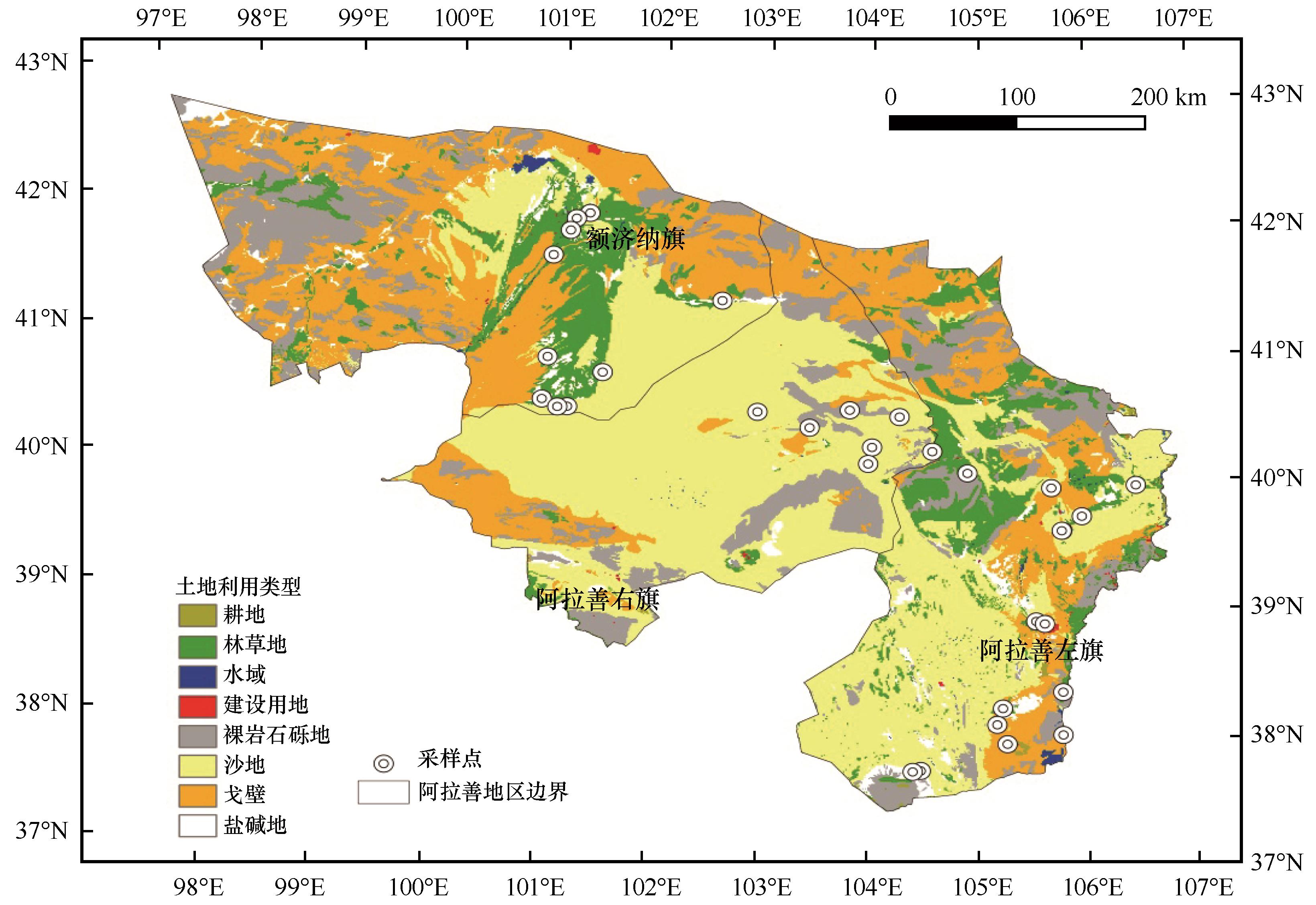
Farifteh J, Van der Meer F, Atzberger C,et al.Quantitative analysis of salt-affected soil reflectance spectra:a comparison of two adaptive methods (PLSR and ANN)[J].Remote Sensing of Environment,2007,110(1):59-78.
|
| 8 |
扶卿华,倪绍祥,王世新,等.土壤盐分含量的遥感反演研究[J].农业工程学报,2007(1):48-54.
|
| 9 |
Vermeulen D, Van Niekerk A.Machine learning performance for predicting soil salinity using different combinations of geomorphometric covariates[J].Geoderma,2017,299:1-12.
|
| 10 |
张智韬,魏广飞,姚志华,等.基于无人机多光谱遥感的土壤含盐量反演模型研究[J].农业机械学报,2019,50(12):151-160.
|
| 11 |
姜红,玉素甫江•如素力,热伊莱•卡得尔,等.基于神经网络模型的干旱区绿洲土壤盐渍化评价分析[J].地球信息科学学报,2017,19(7):983-993.
|
| 12 |
Rodriguez-Galiano V F, Chica-Olmo M, Abarca-Hernandez F,et al.Random forest classification of mediterranean land cover using multi-seasonal imagery and multi-seasonal texture[J].Remote Sensing of Environment,2012,121:93-107.
|
| 13 |
王丽爱,马昌,周旭东,等.基于随机森林回归算法的小麦叶片SPAD值遥感估算[J].农业机械学报,2015,46(1):259-265.
|
| 14 |
Said N, Henning B, Joachim H,et al.Modeling and mapping of soil salinity with reflectance spectroscopy and landsat data using two quantitative methods (PLSR and MARS) [J].Remote Sensing,2014,6:10813-10834.
|
| 15 |
Yu H, Liu M, Du B,et al.Mapping soil salinity/sodicity by using Landsat OLI imagery and PLSR algorithm over semiarid west Jilin Province,China[J].Sensors,2018,18(4):1-17.
|
| 16 |
Fourati H T, Bouaziz M, Benzina M,et al.Modeling of soil salinity within a semi-arid region using spectral analysis[J].Arabian Journal of Geosciences,2015,8(12):11175-11182.
|
| 17 |
屈永华,段小亮,高鸿永,等.内蒙古河套灌区土壤盐分光谱定量分析研究[J].光谱学与光谱分析,2009,29(5):1362-1366.
|
| 18 |
张子璇,宋雨桐,张惠中,等.水文气候影响下黄河三角洲土壤盐分时空动态[J].应用生态学报,2021,32(4):1393-1405.
|
| 19 |
卢周扬帆,许端阳,张绪教,等.阿拉善干旱荒漠区土地利用变化对生态系统服务的影响[J].水土保持研究,2019,26(6):296-302.
|
| 20 |
万炜,颜长珍.阿拉善高原生态环境退化研究进展[J].地球环境学报,2018,9(2):109-122.
|
| 21 |
鲍士旦.土壤农化分析[M].北京:中国农业出版社,2000:178-199.
|
| 22 |
杨晓潇.天津市滨海新区土壤盐分反演及土壤质量评价[D].北京:北京林业大学,2019.
|
| 23 |
Yu H, Liu M, Du B,et al.Analysis of salinization dynamics by remote sensing in Hetao Irrigation District of North China[J].Agricultural Water Management,2010,97(12):1952-1960.
|
| 24 |
Chavez P S, Berlin G L, Sowers L B.Statistical method for selecting Landsat MSS ratios[J].Journal of Applied Photographic Engineering,1982,8(1):23-30.
|
| 25 |
Allbed A, Kumar L, Aldakheel Y Y.Assessing soil salinity using soil salinity and vegetation indices derived from IKONOS high-spatial resolution imageries:applications in a date palm dominated region[J].Geoderma,2014,230/231(7):1-8.
|
| 26 |
Douaoui A E K, Nicolas H, Walter C.Detecting salinity hazards within a semiarid context by means of combining soil and remote-sensing data[J].Geoderma,2006,134(1/2):217-230.
|
| 27 |
Bannari A, Guedon A M, El-Harti A,et al.Characterization of slightly and moderately saline and sodic soils in irrigated agricultural land using simulated data of advanced land imaging (EO-1) sensor[J].Communications in Soil Science and Plant Analysis,2008,39(19/20):2795-2811.
|
| 28 |
Abbas A, Khan S, Hussain N,et al.Characterizing soil salinity in irrigated agriculture using a remote sensing approach[J].Physics and Chemistry of the Earth,2013,55/57:43-52.
|
| 29 |
Khan N M, Rastoskuev V V, Sato Y,et al.Assessment of hydrosaline land degradation by using a simple approach of remote sensing indicators[J].Agricultural Water Management,2005,77(1/3):96-109.
|
| 30 |
Huete A R.A soil-adjusted vegetation index (SAVI)[J].Remote Sensing of Environment,1988,25(3):295-309.
|
| 31 |
Rouse J W, Hass R W, Schell J A,et al.Monitoring the vernal advancement and retrogradation (green wave effect) of natural vegetation[R].Greenbelt,MD,USA:NASA/GSFC Type III,1974.
|
| 32 |
Bannari A, Morin D, Bonn F,et al.A review of vegetation indices[J].Remote Sensing Reviews,1995,13(1/2):95-120.
|
| 33 |
Alhammad M S, Glenn E P.Detecting date palm trees health and vegetation greenness change on the eastern coast of the United Arab Emirates using SAVI[J].International Journal of Remote Sensing,2008,29(6):1745-1765.
|
| 34 |
代希君,彭杰,张艳丽,等.基于光谱分类的土壤盐分含量预测[J].土壤学报,2016,53(4):909-918.
|
| 35 |
杨小虎,罗艳琴,杨海昌,等.玛纳斯河流域绿洲农田土壤盐分反演及空间分布特征[J].干旱区资源与环境,2021,35(2):156-161.
|
| 36 |
Bui E N, Henderson B L.Vegetation indicators of salinity in northern Queensland[J].Austral Ecology,2003,28(5):539-552.
|
| 37 |
邱元霖,陈策,韩佳,等.植被覆盖条件下的解放闸灌域土壤盐分卫星遥感估算模型[J].节水灌溉,2019(10):108-112.
|
| 38 |
贾艳红,赵传燕,南忠仁.黑河下游地下水波动带土壤盐分空间变异特征分析[J].干旱区地理,2008(3):379-388.
|
| 39 |
吴亚坤,李金彪,高昊辰,等.阿拉善左旗土壤盐分空间变异特征研究[J].土壤,2019,51(5):1030-1035.
|
| 40 |
温利强.我国盐渍土的成因及分布特征[D].合肥:合肥工业大学,2010.
|
| 41 |
王遵亲,祝寿泉,俞仁培,等.中国盐渍土[M].北京:科学出版社,1993.
|
| 42 |
肖生春,肖洪浪.黑河流域绿洲环境演变因素研究[J].中国沙漠,2003,23(4):51-56.
|
| 43 |
张诚.阿拉善沙漠风积砂重矿物组成及物源分析[D].兰州:兰州大学,2020.
|
| 44 |
杜秉晨曦,程勇翔,吴玲.准噶尔盆地植被与土壤盐渍化负关联性变化趋势分析[J].生态学报,2021,41(23):1-13.
|
| 45 |
张义强,王瑞萍,白巧燕.内蒙古河套灌区土壤盐碱化发展变化及治理效果研究[J].灌溉排水学报,2018,37():118-122.
|
 ), 席海洋1(

 甘公网安备 62010202000688号