中国沙漠 ›› 2026, Vol. 46 ›› Issue (2): 164-176.DOI: 10.7522/j.issn.1000-694X.2025.00149
• • 上一篇
王世宇( ), 王雪松()
收稿日期:2025-07-24
修回日期:2025-09-08
出版日期:2026-03-20
发布日期:2026-04-13
通讯作者:
王雪松
作者简介:王世宇(2002—),男,新疆兵团人,研究生,主要从事土壤风蚀方面的研究。E-mail: sywang1210@mail.bnu.edu.cn
基金资助:
Shiyu Wang(), Xuesong Wang()
Received:2025-07-24
Revised:2025-09-08
Online:2026-03-20
Published:2026-04-13
Contact:
Xuesong Wang
摘要:
中国北方干旱半干旱区地形复杂多样、生态环境较为脆弱,土壤风蚀是影响该地区生态系统稳定和社会经济发展的关键因素。本研究采用修正风蚀方程(RWEQ),定量分析了该地区2001—2020年土壤风蚀的空间分布格局和时间动态变化,并结合地理探测器进一步探究了土壤风蚀的驱动因素。结果表明:(1)研究时段内,研究区的多年平均实际土壤风蚀模数为13 449.59 t·km-2·a-1,以剧烈侵蚀为首,主要分布在塔里木盆地中心地带和内蒙古高原中西部;实际土壤风蚀模数总体呈现波动下降的态势,大致以每年102.78 t·km-2的速率下降。(2)研究时段内,研究区不同土地利用类型的实际土壤风蚀模数存在显著差异。无论是发生转换的土地利用类型,还是未发生转换的土地利用类型,2020年的实际土壤风蚀模数:沙地>草地>耕地>建设用地>林地。此外,中国北方干旱半干旱区新增草地和耕地的实际土壤风蚀模数相对较高,分别为13 695.88 t·km-2·a-1和7 933.25 t·km-2·a-1,比研究时段内未发生转换的草地和耕地的实际土壤风蚀模数分别高19.90%和58.53%。(3)在影响研究区土壤风蚀的众多因素中,气候因子是主导因素(q=0.312,P<0.01);其中,风因子与实际土壤风蚀模数呈现出较为显著的中等强度的正相关(r=0.43,P<0.05)。
中图分类号:
王世宇, 王雪松. 2001—2020年中国北方干旱半干旱区土壤风蚀的时空变化及驱动因素[J]. 中国沙漠, 2026, 46(2): 164-176.
Shiyu Wang, Xuesong Wang. Spatiotemporal variation and driving factors of soil wind erosion in the arid and semi-arid areas of northern China in 2001-2020[J]. Journal of Desert Research, 2026, 46(2): 164-176.
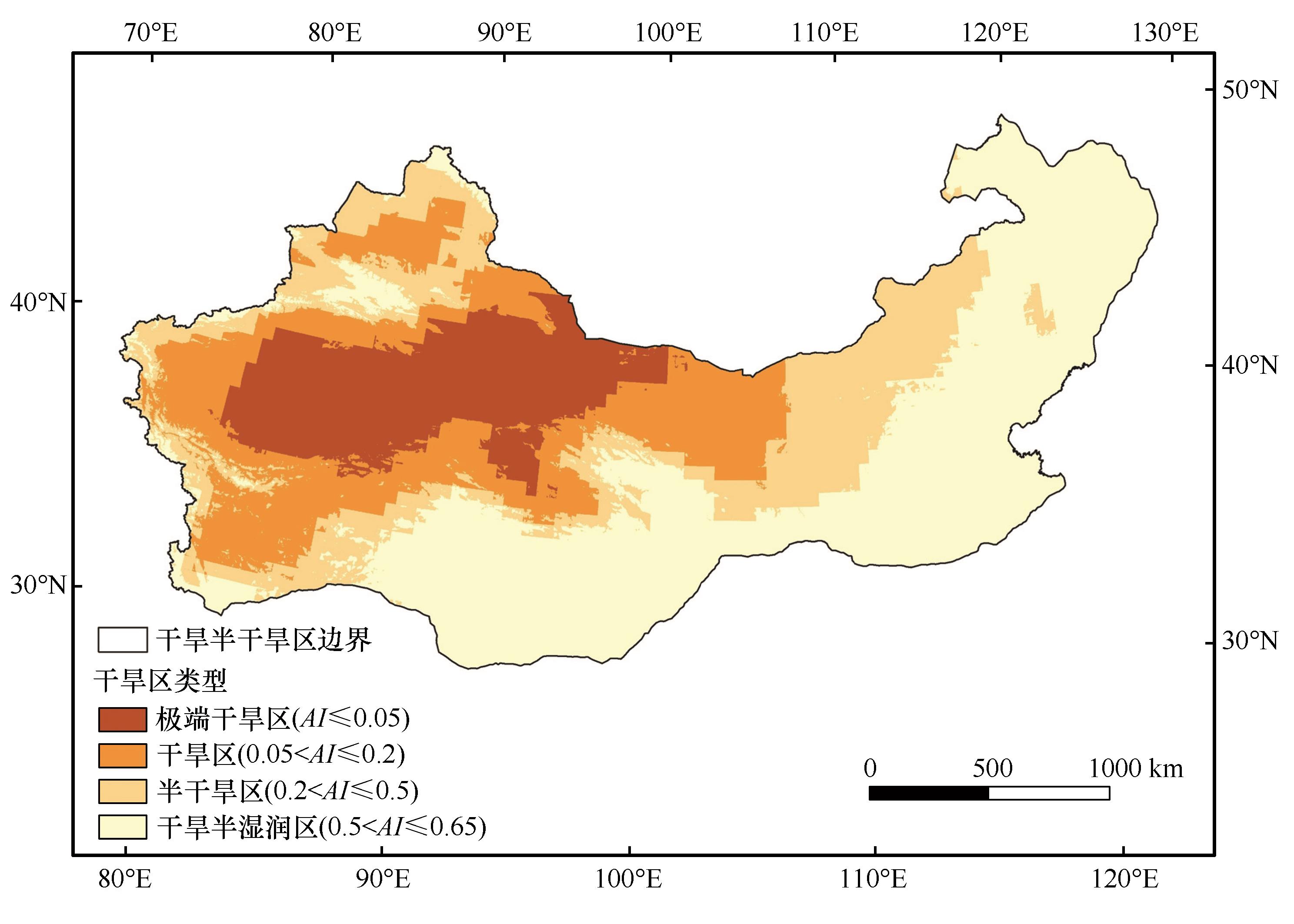
图1 中国北方干旱半干旱区的地理位置注:基于自然资源部标准地图服务网站标准地图(审图号:GS(2024)0650号)制作,底图边界无修改
Fig.1 Geographical location in the arid and semi-arid areas of northern China (ASANC)
| 模型名称 | 输入数据 | 参数 | 时间尺度 | 时间分辨率 | 空间分辨率 | 数据网址 |
|---|---|---|---|---|---|---|
| RWEQ | 气象数据 | 风速 | 2001—2020年 | 逐时 | 0.5°×0.625° | https://disc.gsfc.nasa.gov |
| 降水 | 2001—2020年 | 逐时 | 0.5°×0.625° | https://disc.gsfc.nasa.gov | ||
| 雪深 | 2001—2020年 | 逐时 | 0.5°×0.625° | https://disc.gsfc.nasa.gov | ||
| 潜在蒸散发 | 2001—2020年 | 逐月 | 1 km×1 km | https://www.tpdc.ac.cn | ||
| 土壤数据 | 土壤质地 | 不变量 | 不变量 | 1 km×1 km | https://www.ncdc.ac.cn | |
| 地形数据 | DEM | 不变量 | 不变量 | 250 m×250 m | https://www.resdc.cn | |
| 植被数据 | NDVI | 2001—2020年 | 逐月 | 1 km×1 km | https://www.resdc.cn | |
| 土地利用 | CLCD | 2001—2020年 | 逐年 | 30 m×30 m | https://www.ncdc.ac.cn |
表1 模型输入参数及数据说明
Table 1 Model input parameters and data description
| 模型名称 | 输入数据 | 参数 | 时间尺度 | 时间分辨率 | 空间分辨率 | 数据网址 |
|---|---|---|---|---|---|---|
| RWEQ | 气象数据 | 风速 | 2001—2020年 | 逐时 | 0.5°×0.625° | https://disc.gsfc.nasa.gov |
| 降水 | 2001—2020年 | 逐时 | 0.5°×0.625° | https://disc.gsfc.nasa.gov | ||
| 雪深 | 2001—2020年 | 逐时 | 0.5°×0.625° | https://disc.gsfc.nasa.gov | ||
| 潜在蒸散发 | 2001—2020年 | 逐月 | 1 km×1 km | https://www.tpdc.ac.cn | ||
| 土壤数据 | 土壤质地 | 不变量 | 不变量 | 1 km×1 km | https://www.ncdc.ac.cn | |
| 地形数据 | DEM | 不变量 | 不变量 | 250 m×250 m | https://www.resdc.cn | |
| 植被数据 | NDVI | 2001—2020年 | 逐月 | 1 km×1 km | https://www.resdc.cn | |
| 土地利用 | CLCD | 2001—2020年 | 逐年 | 30 m×30 m | https://www.ncdc.ac.cn |
| 交互类型 | 判定依据 |
|---|---|
| 非线性减弱 | |
| 单因子非线性减弱 | |
| 双因子增强 | |
| 独立 | |
| 非线性增强 |
表2 因子交互作用的类型[50]
Table 2 Types of interaction between two covariates[50]
| 交互类型 | 判定依据 |
|---|---|
| 非线性减弱 | |
| 单因子非线性减弱 | |
| 双因子增强 | |
| 独立 | |
| 非线性增强 |
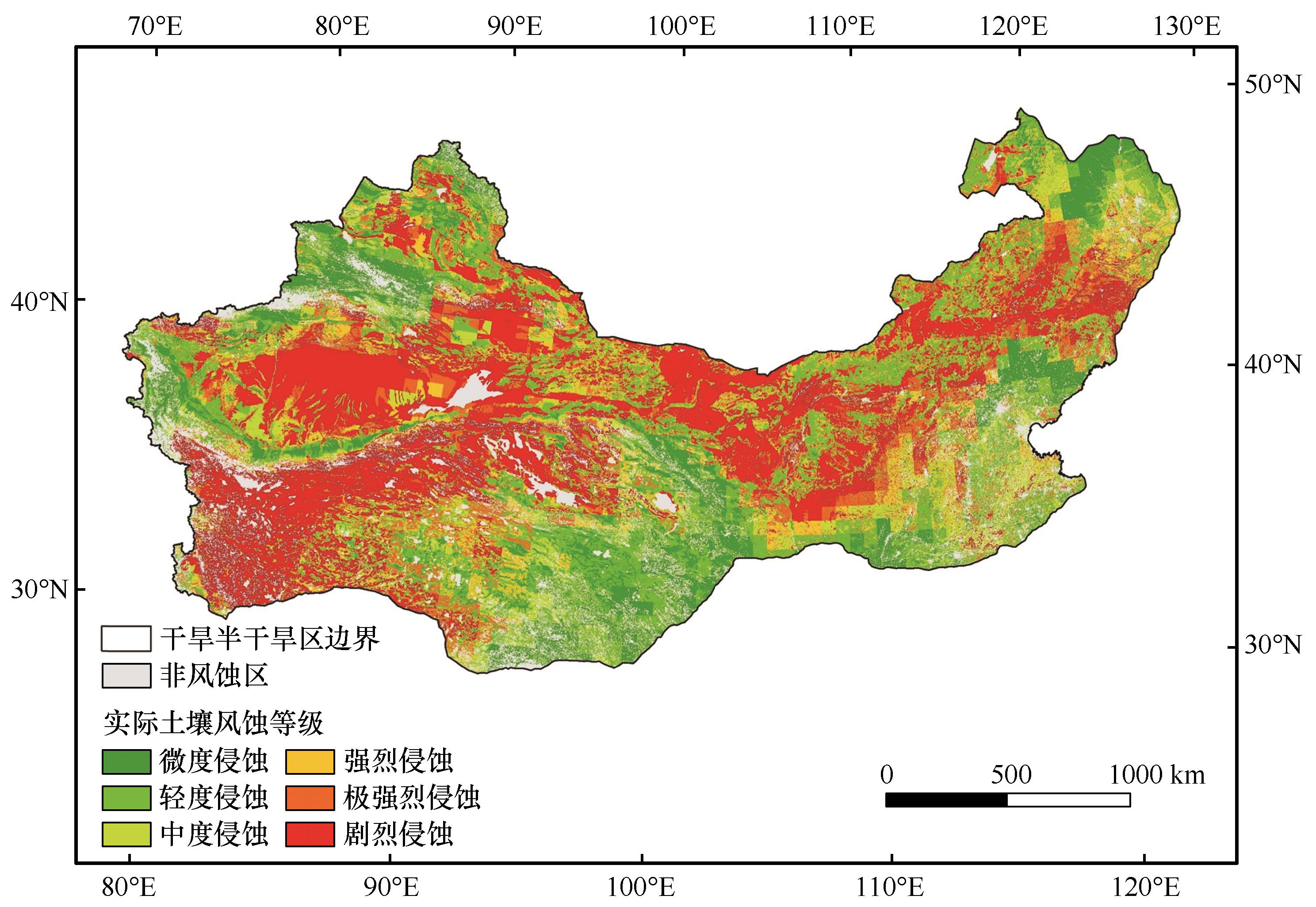
图2 2001—2020年中国北方干旱半干旱区多年平均实际风蚀等级空间分布注:基于自然资源部标准地图服务网站标准地图(审图号:GS(2024)0650号)制作,底图边界无修改
Fig.2 Spatial distribution of multi-year average actual soil wind erosion modulus in the ASANC from 2001 to 2020
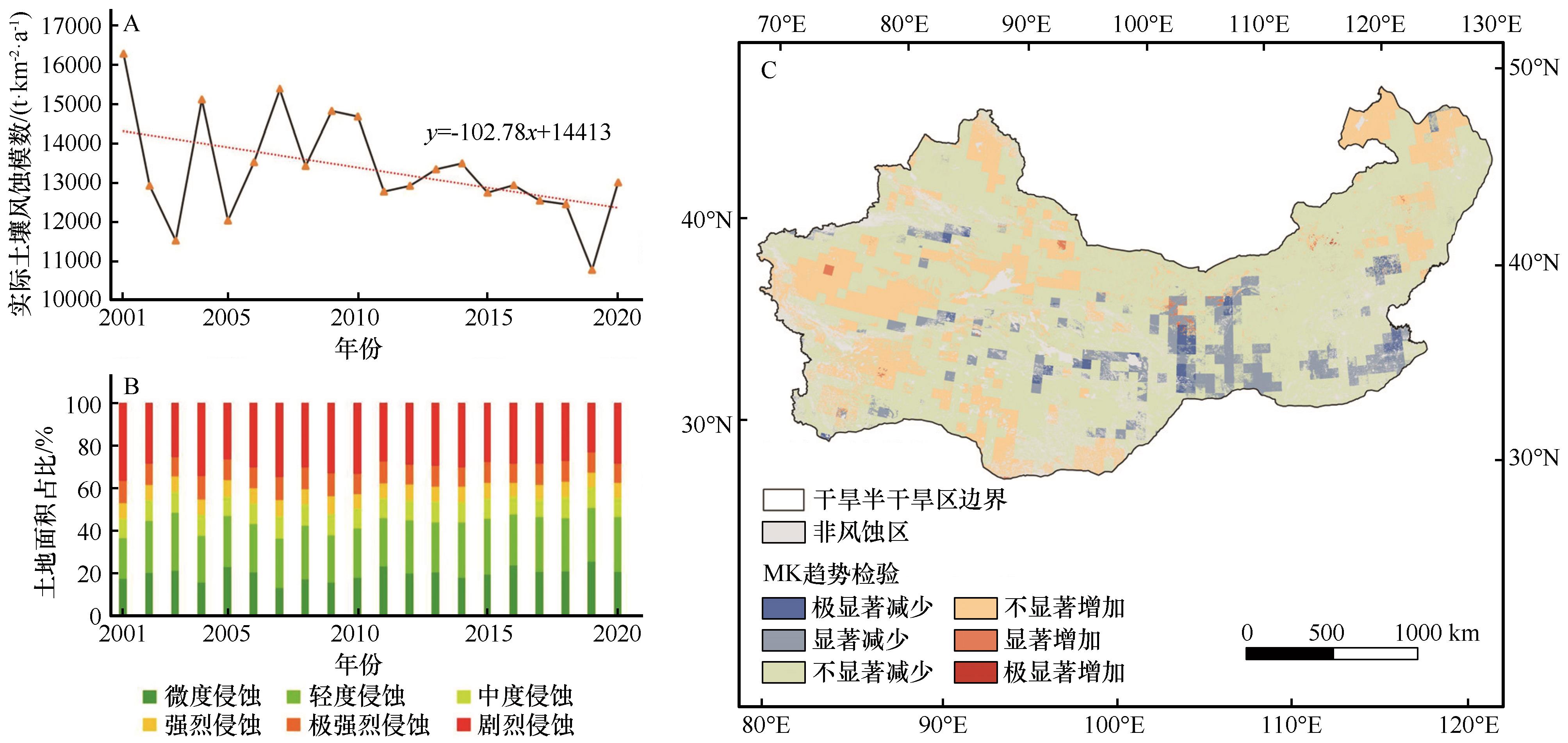
图3 2001—2020年中国北方干旱半干旱区实际土壤风蚀模数的时空动态变化注:基于自然资源部标准地图服务网站标准地图(审图号:GS(2024)0650号)制作,底图边界无修改
Fig.3 Spatiotemporal dynamics of actual soil wind erosion modulus in the ASANC from 2001 to 2020
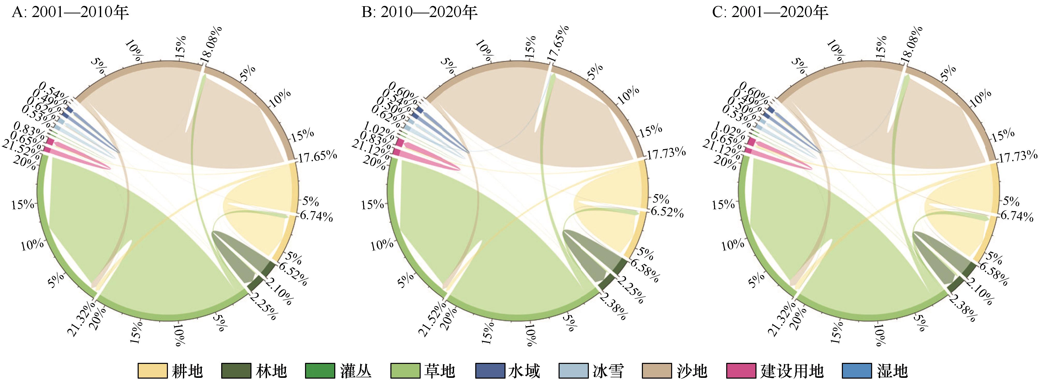
图4 2001—2020年中国北方干旱半干旱区土地利用转移弦图
Fig.4 Landuse transfer chord diagram in the ASANC from 2001 to 2020
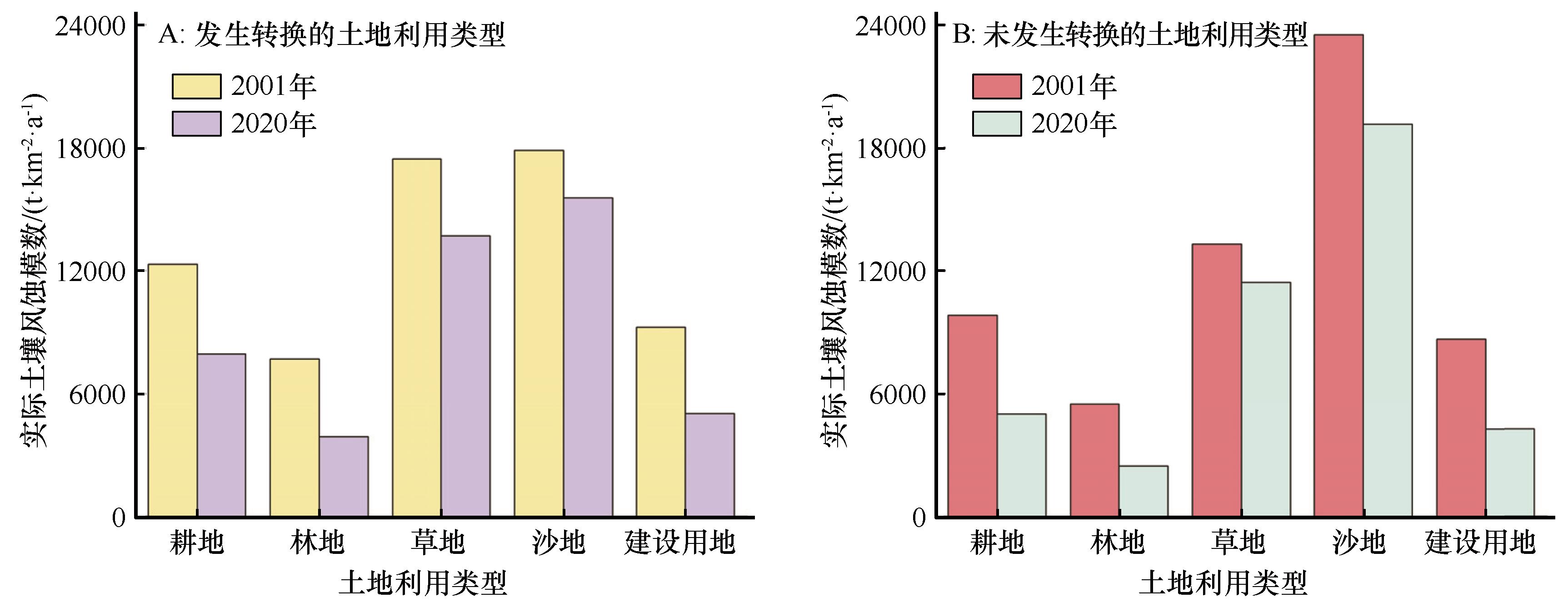
图5 2001年和2020年中国北方干旱半干旱区不同土地利用类型的实际土壤风蚀模数
Fig.5 The actual soil wind erosion modulus of different landuse in the ASANC in 2001 and 2020
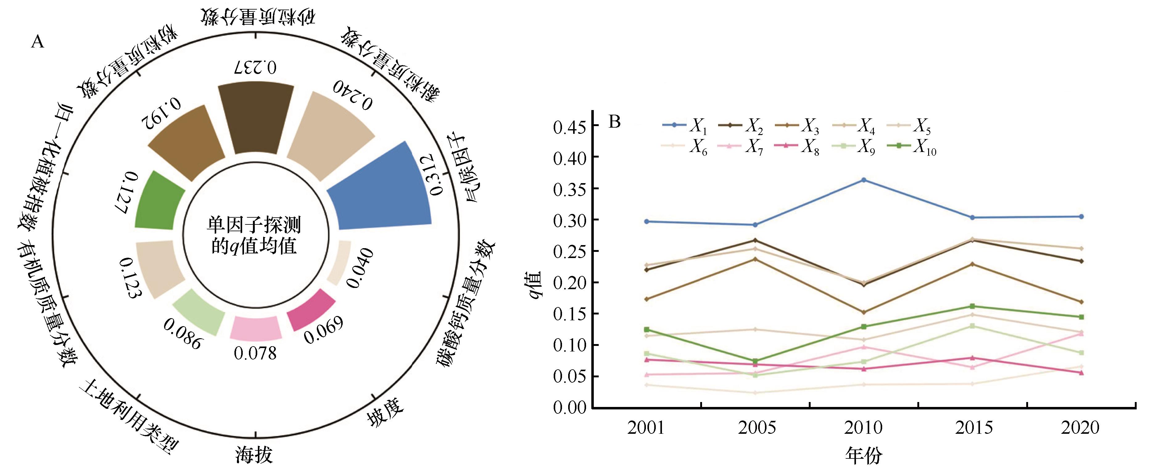
图6 2001—2020年中国北方干旱半干旱区实际土壤风蚀模数的单因子探测注:X1代表气候因子,X2代表砂粒质量分数,X3代表粉粒质量分数,X4代表黏粒质量分数,X5代表有机质质量分数,X6代表碳酸钙质量分数,X7代表海拔,X8代表坡度,X9代表土地利用类型,X10代表归一化植被指数
Fig.6 Factor detection of the actual soil wind erosion modulus in the ASANC from 2001 to 2020
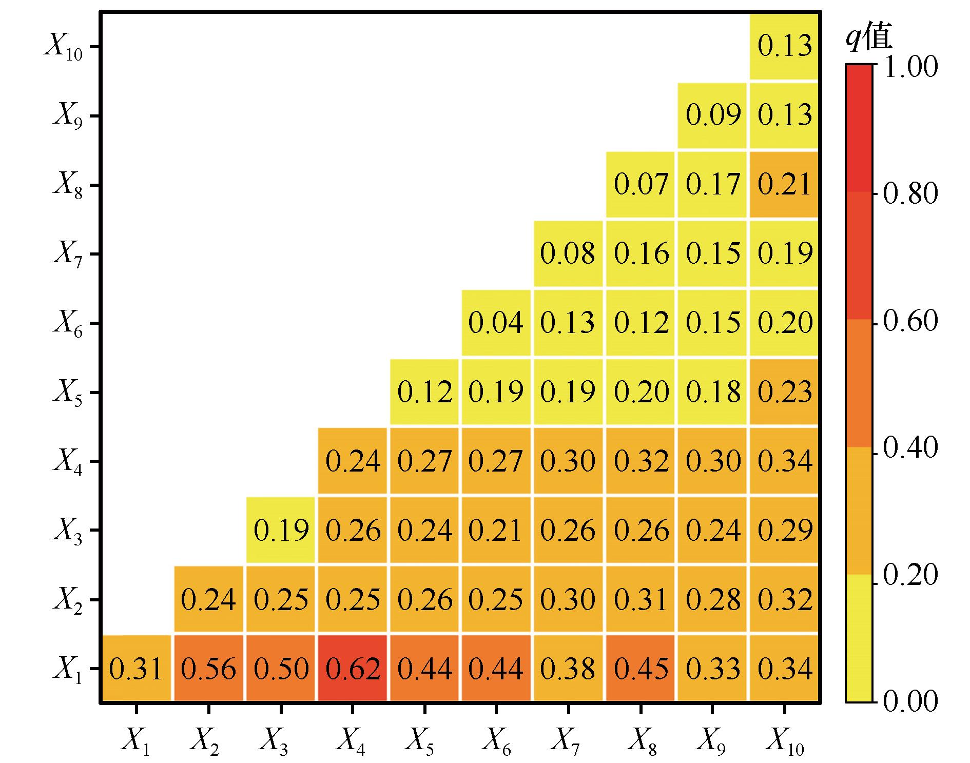
图7 2001—2020年中国北方干旱半干旱区实际土壤风蚀模数的交互探测注:X1代表气候因子,X2代表砂粒质量分数,X3代表粉粒质量分数,X4代表黏粒质量分数,X5代表有机质质量分数,X6代表碳酸钙质量分数,X7代表海拔,X8代表坡度,X9代表土地利用类型,X10代表归一化植被指数
Fig.7 Interaction detection of the actual soil wind erosion modulus in the ASANC from 2001 to 2020
| 研究区域 | 研究时段 | 研究方法 | 纬度 | 经度 | 原文结果 /(t·km-2·a-1) | 本文结果 /(t·km-2·a-1) |
|---|---|---|---|---|---|---|
新疆 准东地区 | 2015年 | 137Cs示踪法 | 44°16′14″N | 90°21′00″E | 2 644.08 | 3 678.03 |
| 45°06′37″N | 88°35′20″E | 3 855.57 | 5 266.36 | |||
| 44°29′58″N | 89°54′54″E | 1 871.13 | 4 340.87 | |||
| 44°47′12″N | 89°21′06″E | 1 840.09 | 1 197.04 | |||
| 2016年 | 粒度对比法 | 44°06′34″N | 90°00′55″E | 2 585.58 | 2 842.68 | |
| 45°00′05″N | 89°14′04″E | 2 857.28 | 2 199.54 |
表3 模型模拟验证结果对比[55-56]
Table 3 Comparison results of RWEQ with measurement[55-56]
| 研究区域 | 研究时段 | 研究方法 | 纬度 | 经度 | 原文结果 /(t·km-2·a-1) | 本文结果 /(t·km-2·a-1) |
|---|---|---|---|---|---|---|
新疆 准东地区 | 2015年 | 137Cs示踪法 | 44°16′14″N | 90°21′00″E | 2 644.08 | 3 678.03 |
| 45°06′37″N | 88°35′20″E | 3 855.57 | 5 266.36 | |||
| 44°29′58″N | 89°54′54″E | 1 871.13 | 4 340.87 | |||
| 44°47′12″N | 89°21′06″E | 1 840.09 | 1 197.04 | |||
| 2016年 | 粒度对比法 | 44°06′34″N | 90°00′55″E | 2 585.58 | 2 842.68 | |
| 45°00′05″N | 89°14′04″E | 2 857.28 | 2 199.54 |
| [1] | Li C J, Fu B J, Wang S,et al.Drivers and impacts of changes in China's drylands[J].Nature Reviews Earth & Environment,2021,2(12):858-873. |
| [2] | Borrelli P, Panagos P, Alewell C,et al.Policy implications of multiple concurrent soil erosion processes in European farmland[J].Nature Sustainability,2023,6(1):103-112. |
| [3] | Field J P, Belnap J, Breshears D D,et al.The ecology of dust[J].Frontiers in Ecology and the Environment,2010,8(8):423-430. |
| [4] | Buschiazzo D E, Zobeck T M.Validation of WEQ, RWEQ and WEPS wind erosion for different arable land management systems in the Argentinean Pampas[J].Earth Surface Processes and Landforms,2008,33(12):1839-1850. |
| [5] | Chepil W S.Dynamics of wind erosion: nature of movement of soil by wind[J].Soil Science,1945,60(4):305-320. |
| [6] | Du H D, Jiao J Y, Jia Y F,et al.Phytogenic mounds of four typical shoot architecture species at different slope gradients on the Loess Plateau of China[J].Geomorphology,2013,193:57-64. |
| [7] | Wu Z T, Wang M Y, Zhang H,et al.Vegetation and soil wind erosion dynamics of sandstorm control programs in the agro-pastoral transitional zone of Northern China[J].Frontiers of Earth Science,2019,13(2):430-443. |
| [8] | Borrelli P, Robinson D A, Fleischer L R,et al.An assessment of the global impact of 21st century land use change on soil erosion[J].Nature Communications,2017,8:2013. |
| [9] | Cook B I, Miller R L, Seager R.Dust and sea surface temperature forcing of the 1930s “Dust Bowl” drought[J].Geophysical Research Letters,2008,35(8):114-118. |
| [10] | Copeland N S, Sharratt B S, Wu J Q,et al.A wood-strand material for wind erosion control: effects on total sediment loss, PM10 vertical flux, and PM10 loss[J].Journal of Environmental Quality,2009,38(1):139-148. |
| [11] | Bartkowski B, Schepanski K, Bredenbeck S,et al.Wind erosion in european agricultural landscapes:more than physics[J].People and Nature,2023,5(1):34-44. |
| [12] | Webb N P, McGowan H A, Phinn S R,et al.AUSLEM (AUStralian Land Erodibility Model):a tool for identifying wind erosion hazard in Australia[J].Geomorphology,2006,78(3/4):179-200. |
| [13] | 中华人民共和国水利部.2024年中国水土保持公报[R].北京:中华人民共和国水利部,2025:1-62. |
| [14] | 麻硕士,陈智.土壤风蚀测试与控制技术[M].北京:科学出版社,2010:113-114. |
| [15] | 张春来,宋长青,王振亭,等.土壤风蚀过程研究回顾与展望[J].地球科学进展,2018,33(1):27-41. |
| [16] | 王仁德,李庆,常春平,等.土壤风蚀野外测量技术研究进展[J].中国沙漠,2019,39(4):113-128. |
| [17] | Jarrah M, Mayel S, Tatarko J,et al.A review of wind erosion models:data requirements, processes, and validity[J].Catena,2020,187:104388. |
| [18] | Woodruff N P, Siddoway F H.A wind erosion equation[J].Soil Science Society of America Journal,1965,29(5):602-608. |
| [19] | Pasak V.Wind erosion on soil[J].VUM Zbraslaav Scientific Monographs,1973(3):78-89. |
| [20] | Bocharov A P.A Description of Devices Used in the Study of Wind Erosion of Soils[M].New Delhi,India:Oxonian Press,1984. |
| [21] | Williams J R, Jones C A, Dyke P T.A modeling approach to determining the relationship between erosion and soil productivity[J].Transactions of the ASAE,1984,27(1):129-144. |
| [22] | Hagen L J.A wind erosion prediction system to meet user needs[J].Journal of Soil and Water Conservation,1991,46(2):106-111. |
| [23] | Shao Y P, Raupach M R, Leys J F.A model for prediction aeolian sand drift and dust entrainment on scales from paddock to region[J].Australian Journal of Soil Research,1996,34(3):309-342. |
| [24] | Fryrear D W, Chen W N, Lester C.Revised wind erosion equation[J].Annals of Arid Zone,2001,40(3):265-279. |
| [25] | Gregory J M, Wilson G R, Singh U B,et al.TEAM: integrated, process-based wind-erosion model[J].Environmental Modelling & Software,2004,19(2):205-215. |
| [26] | Böhner J, Schäfer W, Conrad O,et al.The WEELS model: methods, results and limitations[J].Catena,2003,52(3/4):289-308. |
| [27] | Feng G, Sharratt B.Evaluation of the SWEEP model during high winds on the Columbia Plateau[J].Earth Surface Processes and Landforms,2009,34(11):1461-1468. |
| [28] | 巩国丽,刘纪远,邵全琴.基于RWEQ的20世纪90年代以来内蒙古锡林郭勒盟土壤风蚀研究[J].地理科学进展,2014,33(6):825-834. |
| [29] | 巩国丽,刘纪远,邵全琴.草地覆盖度变化对生态系统防风固沙服务的影响分析:以内蒙古典型草原区为例[J].地球信息科学学报,2014,16(3):426-434. |
| [30] | Gong G, Liu J, Shao Q,et al.Sand-fixing function under the change of vegetation coverage in a wind erosion area in northern China[J].Journal of Resources and Ecology,2014,5(2):105-114. |
| [31] | 江凌,肖燚,欧阳志云,等.基于RWEQ模型的青海省土壤风蚀模数估算[J].水土保持研究,2015,22(1):21-25. |
| [32] | Jiang L, Xiao Y, Zheng H,et al.Spatio-temporal variation of wind erosion in Inner Mongolia of China between 2001 and 2010[J].Chinese Geographical Science,2016,26(2):155-164. |
| [33] | 申陆,田美荣,高吉喜,等.浑善达克沙漠化防治生态功能区防风固沙功能的时空变化及驱动力[J].应用生态学报,2016,27(1):73-82. |
| [34] | 申陆,田美荣,高吉喜.基于RWEQ模型的浑善达克沙漠化防治生态功能区土壤风蚀与主要影响因子分析[J].水土保持研究,2016,23(6):90-97. |
| [35] | Zhang L, Guo Z L, Li J F,et al.Effect of the type of wind data on regional potential wind erosion estimation[J].Frontiers in Environmental Science,2022,10:847128. |
| [36] | 高尚玉,张春来,邹学勇,等.京津风沙源治理工程效益[M].北京:科学出版社,2012. |
| [37] | 陈硕,赵文武.中国干旱半干旱区1990-2020年土壤水蚀时空变化及动态驱动力[J].水土保持学报,2025,39(1):10-20. |
| [38] | 陈硕,赵文武,韩逸.中国干旱半干旱区植被降水利用效率时空变化特征及影响因素分析[J].生态学报,2023,43(24):10295-10307. |
| [39] | Peng S Z, Ding Y X, Liu W Z,et al.1 km monthly temperature and precipitation dataset for China from 1901 to 2017[J].Earth System Science Data,2019,11(4):1931-1946. |
| [40] | Peng S Z, Ding Y X, Wen Z M,et al.Spatiotemporal change and trend analysis of potential evapotranspiration over the Loess Plateau of China during 2011-2100[J].Agricultural and Forest Meteorology,2017,233:183-194. |
| [41] | Yang J, Huang X.The 30 m annual land cover dataset and its dynamic in China from 1990 to 2019[J].Earth System Science Data,2021,13(8):3907-3925. |
| [42] | Fryrear D W, Bilbro J D, Saleh A,et al.RWEQ:improved wind erosion technology[J].Journal of Soil and Water Conservation,2000,55(2):183-189. |
| [43] | Hargreaves G H, Samani Z A.Estimating potential evapotranspiration[J].Journal of the Irrigation and Drainage Division,1982,108(3):225-230. |
| [44] | Saleh A.Soil roughness measurement:chain method[J].Journal of Soil and Water Conservation,1993,48(6):527. |
| [45] | 李军,游松财,黄敬峰.基于GIS的中国陆地表面粗糙度长度的空间分布[J].上海交通大学学报(农业科学版),2006,23(2):185-189. |
| [46] | 尚润阳,祁有祥,赵廷宁,等.植被对风及土壤风蚀影响的野外观测研究[J].水土保持研究,2006,21(4):37-39. |
| [47] | Gocic M, Trajkovic S.Analysis of changes in meteorological variables using Mann-Kendall and Sen's slope estimator statistical tests in Serbia[J].Global and Planetary Change,2013,100:172-182. |
| [48] | Xiao C W, Ye J Q, Esteves R M,et al.Using Spearman's correlation coefficients for exploratory data analysis on big dataset[J].Concurrency and Computation:Practice and Experience,2016,28(14):3866-3878. |
| [49] | 刘瑞,朱道林.基于转移矩阵的土地利用变化信息挖掘方法探讨[J].资源科学,2010,32(8):1544-1550. |
| [50] | 王劲峰,徐成东.地理探测器:原理与展望[J].地理学报,2017,72(1):116-134. |
| [51] | Song Y Z, Wang J F, Ge Y,et al.An optimal parameters-based geographical detector model enhances geographic characteristics of explanatory variables for spatial heterogeneity analysis: cases with different types of spatial data[J].GIScience & Remote Sensing,2020,57(5):593-610. |
| [52] | 迟文峰,白文科,刘正佳,等.基于RWEQ模型的内蒙古高原土壤风蚀研究[J].生态环境学报,2018,27(6):1024-1033. |
| [53] | 王洋洋,肖玉,谢高地,等.基于RWEQ的宁夏草地防风固沙服务评估[J].资源科学,2019,41(5):980-991. |
| [54] | Wang S Y, Xu X M.Spatiotemporal variation in soil wind erosion in the Northern slope of the Tianshan Mountains from 2000 to 2018[J].Land,2024,13(10):1604. |
| [55] | 丁肇龙,汪君,胥鹏海,等.基于137Cs的新疆准东地区不同土地利用类型土壤风蚀特征研究[J].土壤,2018,50(2):398-403. |
| [56] | 张婷婷.准东地区土壤颗粒分形研究及其风蚀量估算[D].乌鲁木齐:新疆大学,2018. |
| [57] | 巩国丽.中国北方土壤风蚀时空变化特征及影响因素分析[D].北京:中国科学院大学,2014. |
| [58] | 杜睿哲,李文栋,高文浩,等.气候、地表覆被变化对砒砂岩区风蚀时空变化的影响[J].水土保持研究,2023,30(5):31-40. |
| [59] | 李庆,周娜,王盛,等.气候变化和人类活动对土壤风蚀影响的定量评估:以内蒙古自治区为例[J].中国沙漠,2024,44(1):178-188. |
| [60] | 胡媛,王宗乾,刘卫,等.一种基于CNN-SVR多模态信息融合的GNSS-R风速反演研究[J].测绘科学,2023,48(12):74-83. |
| [61] | Lian J, Huang S R, Shao J H,et al.TerraWind:a deep learning-based near-surface winds downscaling model for complex terrain region[J].Geophysical Research Letters,2024,51(23):e2024GL112124. |
| [62] | 南岭,杜灵通,王锐.土壤风蚀模型研究进展[J].世界科技研究与发展,2013,35(4):505-509. |
| [63] | Lyu X, Li X B, Wang H,et al.Soil wind erosion evaluation and sustainable management of typical steppe in Inner Mongolia,China[J].Journal of Environmental Management,2021,277:111488. |
| [64] | Kaplan S, Basaran M, Erpul G.Assessing the performance of wind erosion prediction models of RWEQ and SWEEP by direct measurements in an arid region[J].Soil and Tillage Research,2024,240:106086. |
| [1] | 李晓鹏, 李康, 李贺. 甘肃省干旱演变特征及主导因子[J]. 中国沙漠, 2025, 45(6): 103-112. |
| [2] | 李彤, 朱睿, 李晓光, 康健, 山建安, 李榕, 尹振良. 基于InVEST模型的祖厉河流域土壤保持研究[J]. 中国沙漠, 2025, 45(6): 312-322. |
| [3] | 姜志伟, 杨智博, 杨清, 胡洁, 刘茜雅, 于玲玲, 张红红, 淡照晶, 田磊. 2000—2022年库布齐沙漠植被覆盖度时空变化及其驱动因子[J]. 中国沙漠, 2025, 45(5): 124-133. |
| [4] | 李思琪, 王海兵, 袁晓飞, 敖胡日查, 杨皓钦. 毛乌素沙地景观生态风险时空演变及驱动力[J]. 中国沙漠, 2025, 45(5): 230-240. |
| [5] | 徐德华, 刘强, 李端, 李继彦. 1986—2023年吕梁山区归一化植被指数(NDVI)动态及驱动力[J]. 中国沙漠, 2025, 45(5): 78-91. |
| [6] | 王卫国, 谢欢, 冯国庆, 家淑珍. 京津风沙源治理工程区生态环境质量及驱动力[J]. 中国沙漠, 2025, 45(4): 139-152. |
| [7] | 周得龙, 王永芳, 郭恩亮, 红英, 马浩文, 慕全飞, 王妍力. 科尔沁沙地生境质量演变与预测[J]. 中国沙漠, 2025, 45(4): 211-226. |
| [8] | 刘永杰, 杜鹤强, 范亚伟, 杨胜飞. 基于Google Earth Engine(GEE)的毛乌素沙地风蚀荒漠化过程监测[J]. 中国沙漠, 2025, 45(2): 262-274. |
| [9] | 贾虹, 刘连友, 刘吉夫. 共和盆地土地荒漠化敏感性评估[J]. 中国沙漠, 2025, 45(1): 1-9. |
| [10] | 陈兵兵, 盖迎春, 宋忠航, 吴向楠, 艾宇, 杨映, 王生棠, 刘宇烁. 祁连山地区生态质量时空变化及驱动力[J]. 中国沙漠, 2024, 44(6): 258-267. |
| [11] | 刘二燕, 赵媛媛, 周蝶, 武海岩, 高广磊, 丁国栋. 科尔沁-浑善达克沙地2000—2020年土地沙化时空变化格局[J]. 中国沙漠, 2024, 44(4): 46-56. |
| [12] | 段翰晨, 黄背英. 基于AHP与改进型MEDALUS模型耦合的科尔沁沙地土地沙漠化敏感性综合评价[J]. 中国沙漠, 2024, 44(4): 137-148. |
| [13] | 杨华庆, 朱睿, 尹振良, 山建安, 张薇, 方春爽. 2001—2020年黄河流域水源涵养区植被覆盖变化及其对气候变化和人类活动的响应[J]. 中国沙漠, 2024, 44(4): 57-70. |
| [14] | 申子傲, 吴静, 李纯斌. 2000—2020年河西内陆河流域植被覆盖时空变化特征及其驱动力[J]. 中国沙漠, 2024, 44(3): 119-127. |
| [15] | 蔡明玉, 贾飚, 常学礼. 景观格局因子交互作用对科尔沁沙地沙漠化的影响[J]. 中国沙漠, 2024, 44(2): 99-108. |
| 阅读次数 | ||||||
|
全文 |
|
|||||
|
摘要 |
|
|||||
©2018中国沙漠 编辑部
地址: 兰州市天水中路8号 (730000)
电话:0931-8267545
Email:caiedit@lzb.ac.cn;desert@lzb.ac.cn

 甘公网安备 62010202000688号