img

官方微信

高级检索

中国沙漠 ›› 2024, Vol. 44 ›› Issue (2): 99-108.DOI: 10.7522/j.issn.1000-694X.2023.00087

• • 上一篇    下一篇

景观格局因子交互作用对科尔沁沙地沙漠化的影响

蔡明玉1(), 贾飚2, 常学礼3()   

  1. 1.烟台工程职业技术学院,山东 烟台 264006
    2.内蒙古自治区水利科学研究院,内蒙古 呼和浩特 010051
    3.鲁东大学 资源与环境工程学院,山东 烟台 264025
  • 收稿日期:2023-08-02 修回日期:2023-09-11 出版日期:2024-03-20 发布日期:2024-03-19
  • 通讯作者: 常学礼
  • 作者简介:常学礼(E-mail: xlchang@126.com
    蔡明玉(1981—),女,山东烟台人,硕士,副教授,主要从事生态遥感研究。E-mail: 47456830@qq.com
  • 基金资助:
    内蒙古自治区“十三五”水利重大专项(NSK2017-M3);国家自然科学基金项目(41271193)

Impact of interaction of landscape pattern factors on desertification status in Kerqin Sandy Land

Mingyu Cai1(), Biao Jia2, Xueli Chang3()   

  1. 1.Yantai Engineering & Technology College,Yantai 264006,Shandong,China
    2.Water Conservancy Science Research Institute of Inner Mongolia,Hohhot 010051,China
    3.School of Resources and Environmental Engineering,Ludong University,Yantai 264025,Shandong,China
  • Received:2023-08-02 Revised:2023-09-11 Online:2024-03-20 Published:2024-03-19
  • Contact: Xueli Chang

摘要:

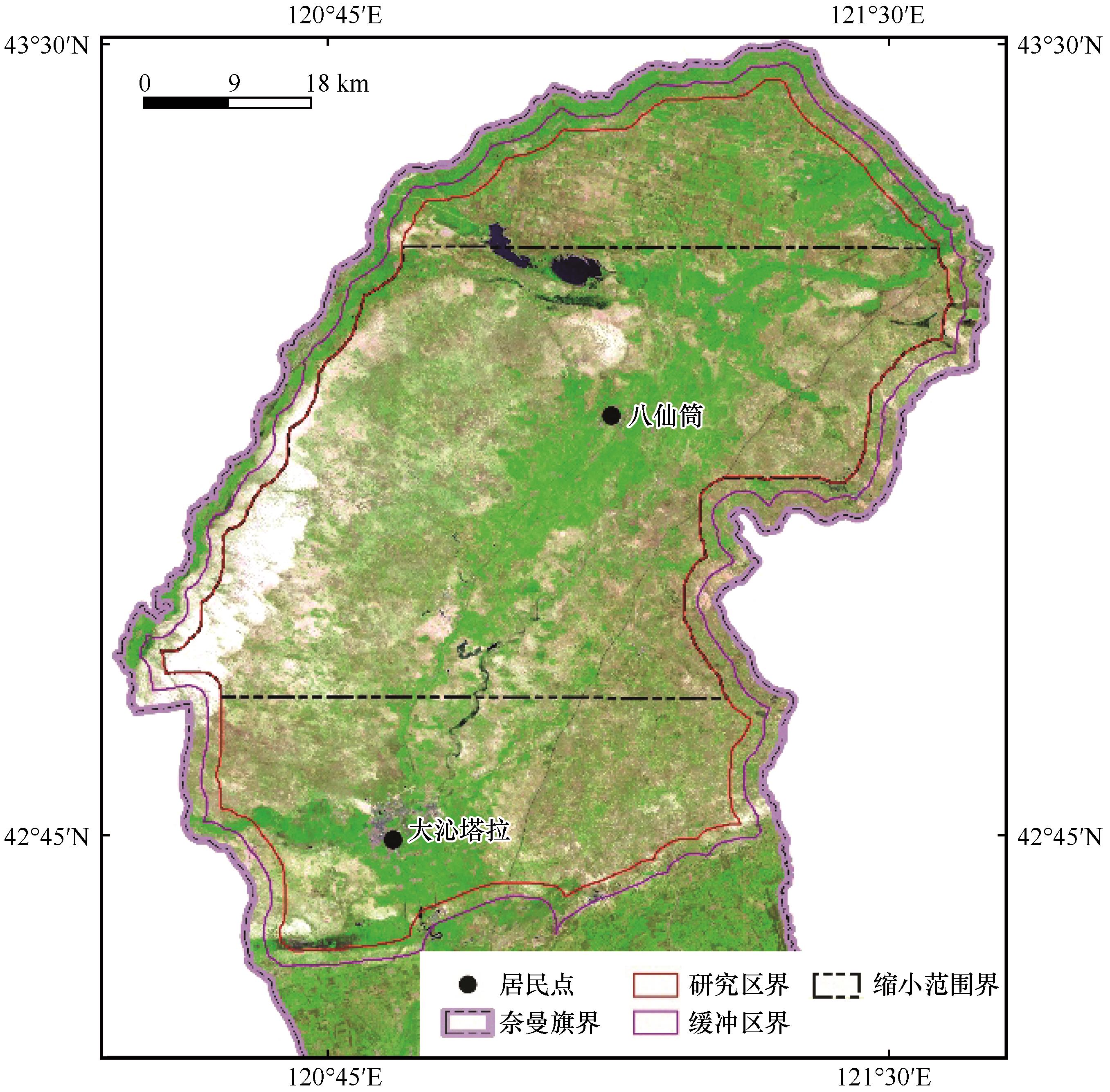
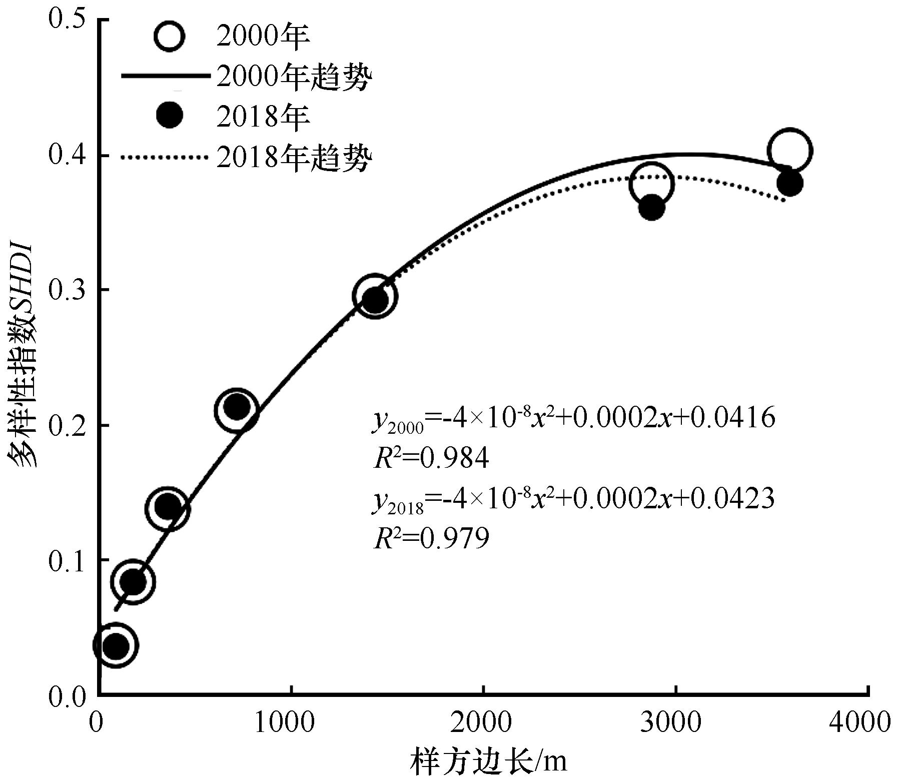
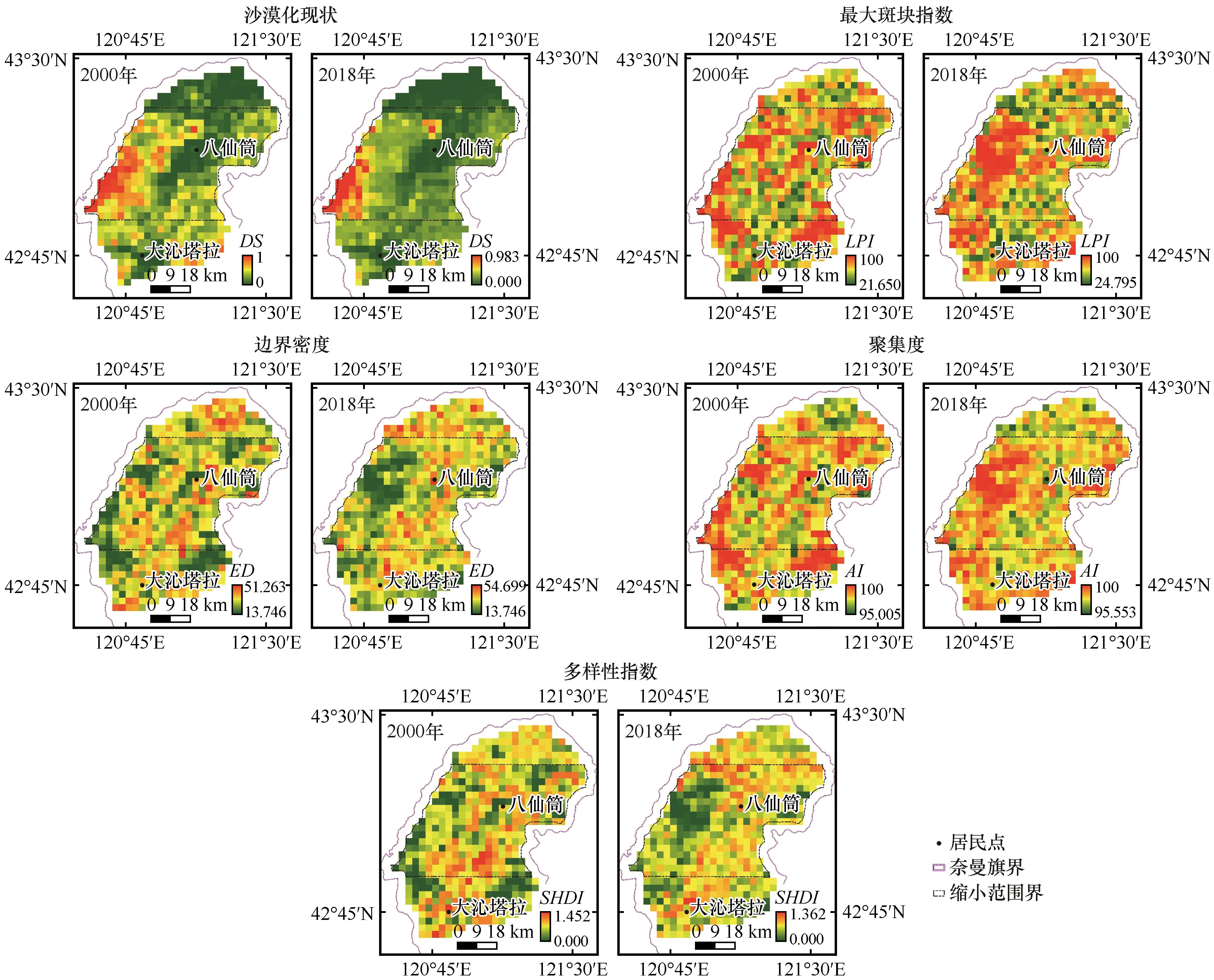
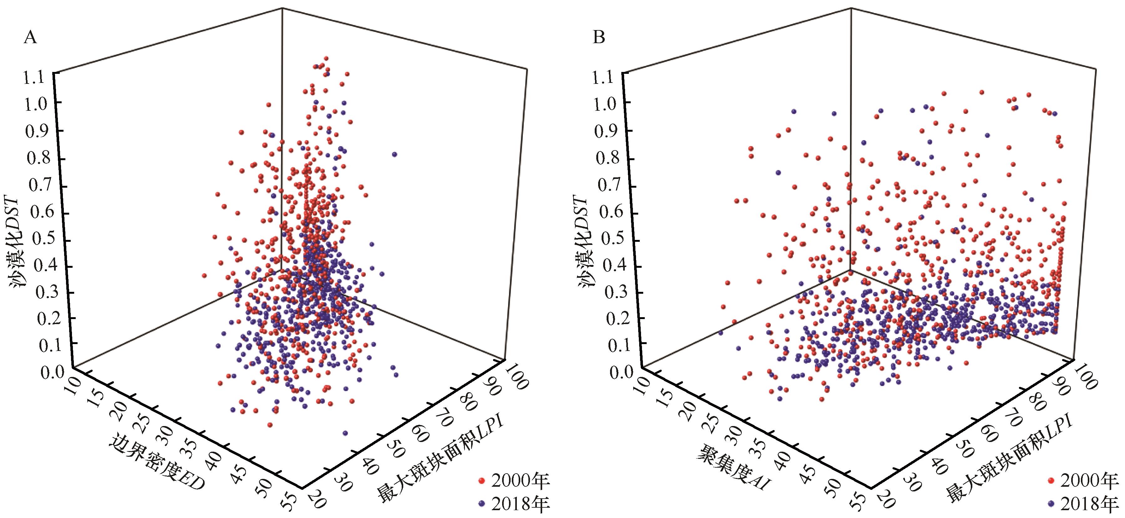
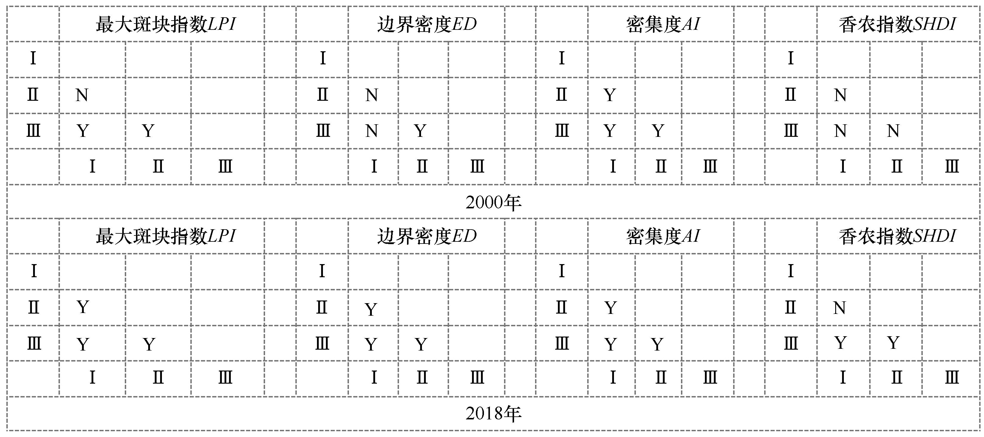
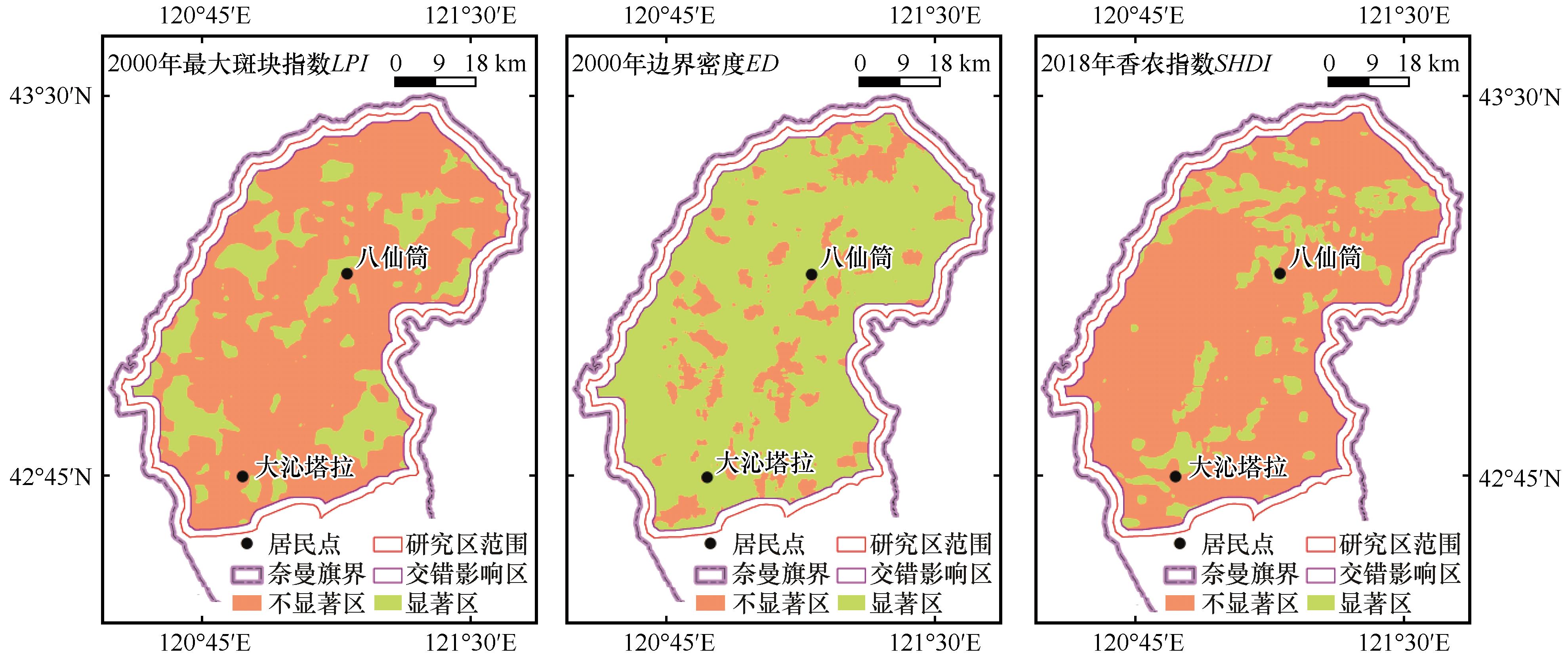
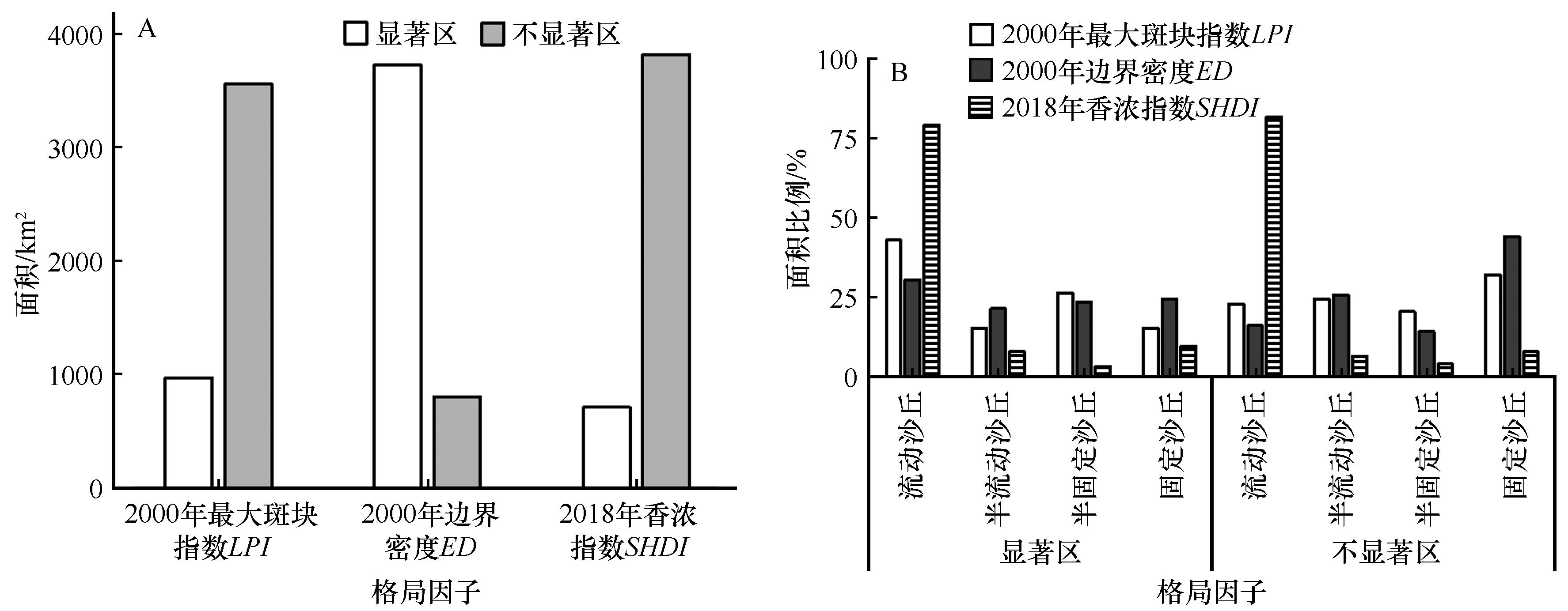
将景观生态学原理运用到沙漠化现状的准确和快捷评估是景观生态学研究面临的一个挑战。本文以2000年和2018年奈曼旗中部沙区土地利用类型数据为基础,选定最大斑块指数(LPI)、边界密度(ED)、聚集度指数(AI)和香农指数(SHDI),借助地理探测器模型和Fragstats软件中的Moving window功能分析了景观格局双因子交互作用及因子分级对沙漠化现状的影响。结果表明:2000—2018年是研究区沙漠化逆转期,沙漠化现状指数由0.393减少到0.288。景观格局双因子交互作用有非线性增强和双因子增强两种形式且对沙漠化现状的影响大于各因子独立作用。不同格局因子分级对沙漠化现状影响存在差异,导致差异原因与不同沙丘类型面积和分布格局有关。在沙漠化现状较强年份(2000年),LPIED分级导致的沙漠化现状显著区,以流动沙丘占优势(30.6%~42.9%),不显著区以固定沙丘占优势(32.0%~44.0%)。在沙漠化现状较弱年份(2018年),SHDI分级导致的沙漠化现状显著区和不显著区都以流动沙丘占优势(均超过79.2%)。景观格局双因子交互对沙漠化现状影响既与时间有关,又与空间范围有关;交互作用对沙漠化现状的影响机制具有非线性特点;研究区范围大小直接影响到景观因子交互作用形式和空间格局(尺度依赖),任何典型案例研究结果不能跨尺度推绎,但方法可以统一。

关键词: 地理探测器, 移动窗口法, 景观格局, 沙漠化现状, 科尔沁沙地

Abstract:

It is a challenge for landscape ecology research to apply the principles of landscape ecology to the accurate and rapid assessment of desertification status (DS). Based on the land use type data in the sandy area of the central Naiman Banner in 2000 and 2018, the maximum patch index (LPI), boundary density (ED), aggregation index (AI) and Shannon diversity index (SHDI) were selected, and the influence of two-factor interaction and grading of landscape pattern on DS was analyzed with the supports of Geo-detector Model and Moving Window function in Fragstats software. DS analysis showed that the desertification process was reversed from 2000 to 2018 in the study area because the DS is reduced from 0.393 to 0.288. There are two forms of two-factor interaction in landscape pattern: nonlinear enhancement and two-factor enhancement, and the influence on DS was greater than that of each factor. There were differences in the influence of different pattern factors on DS, and the differences reasons were related to the area size and distribution pattern of different dune types. In the years when DS was strong (2000), mobile dunes predominated (30.6%-42.9%) in the areas with significant DS caused by LPI and ED classifications, while fixed sand dunes predominated (32.0%-44.0%) in insignificant areas. In the years when DS was weak (2018), both significant and insignificant DS areas caused by SHDI classification were dominated by mobile dunes (both over 79.2%). This study shows that the influence of two-factor interaction of landscape pattern on DS is related to both temporal and spatial scale, and the influence mechanism of interaction on DS has nonlinear characteristics. The study area size directly affects the interaction form and spatial pattern of landscape factors (scale dependent). The results of any typical case study should't be deduced across scales, but the methods can be unified.

Key words: geo-detector model, moving window method, landscape pattern, desertification status, Kerqin Sandy Land

中图分类号: