img

官方微信

高级检索

中国沙漠 ›› 2022, Vol. 42 ›› Issue (3): 85-94.DOI: 10.7522/j.issn.1000-694X.2021.00170

• • 上一篇    下一篇

黄河流域农业绿色发展水平区域差异及影响因素

李魁明1,2(), 王晓燕1(), 姚罗兰3   

  1. 1.首都师范大学 资源环境与旅游学院,北京 100048
    2.防灾科技学院 应急管理学院,河北 三河 065201
    3.北京农业职业学院 国际教育学院,北京 100012
  • 收稿日期:2021-10-18 修回日期:2021-11-02 出版日期:2022-05-20 发布日期:2022-06-01
  • 通讯作者: 王晓燕
  • 作者简介:王晓燕(E-mail: wangxy@cnu.edu.cn
    李魁明(1989—),男,湖北洪湖人,博士研究生,讲师,主要从事流域农业非点源研究。E-mail: 809927535@qq.com

Regional differences and driving factors of agricultural green development level in the Yellow River Basin

Kuiming Li1,2(), Xiaoyan Wang1(), Luolan Yao3   

  1. 1.College of Resources,Environment and Tourism,Capital Normal University,Beijing 100048,China
    2.College of Emergency Management,Institute of Disaster Prevention,Sanhe 065201,Hebei,China
    3.International Education College,Beijing Vocational College of Agriculture,Beijing 100012,China
  • Received:2021-10-18 Revised:2021-11-02 Online:2022-05-20 Published:2022-06-01
  • Contact: Xiaoyan Wang

摘要:

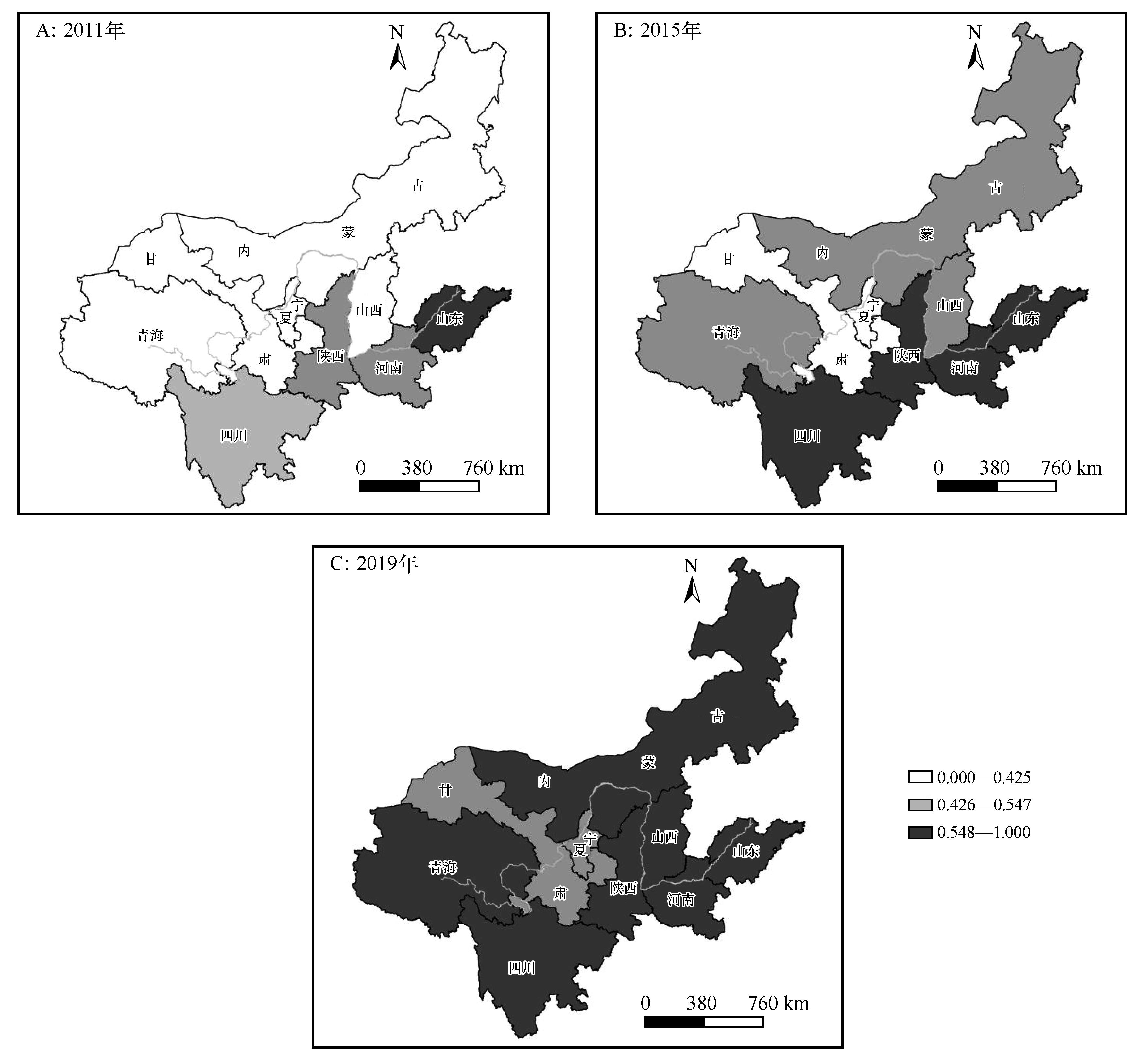
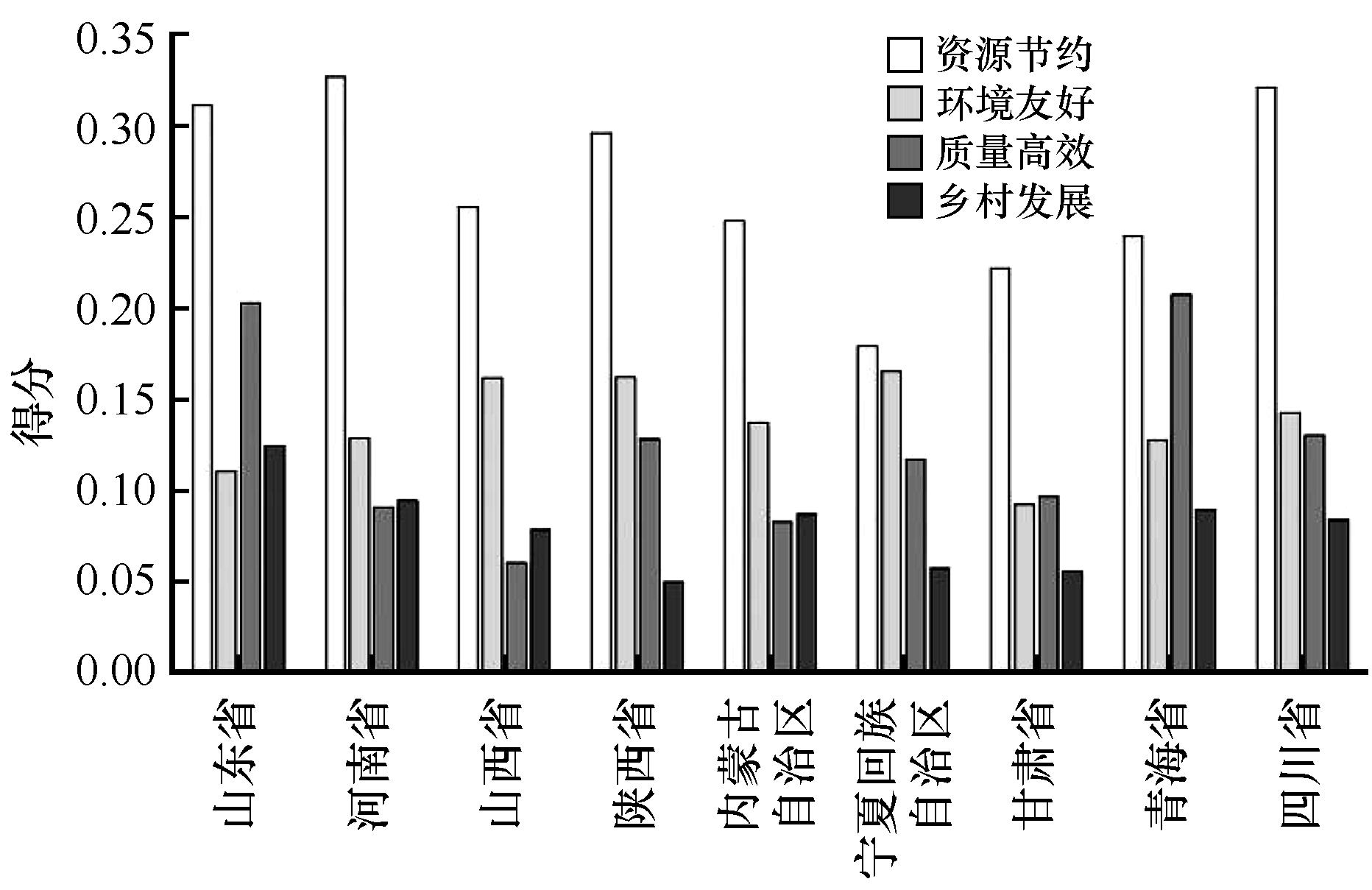
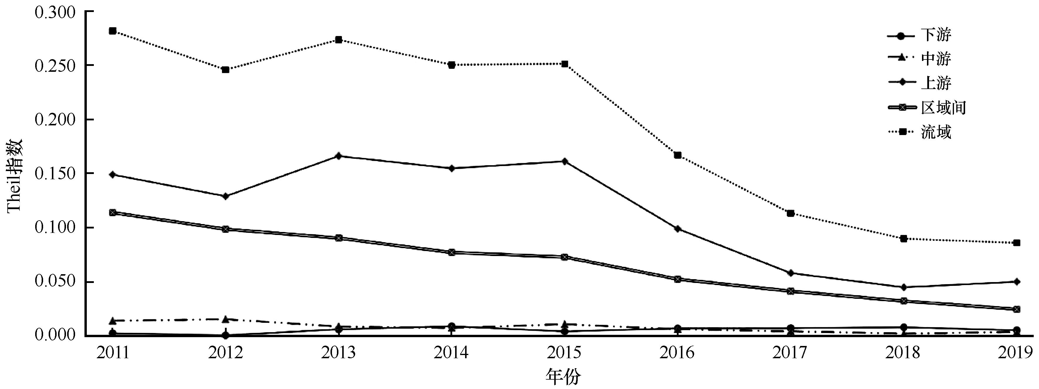
推进农业绿色发展,是推进农业高质量发展、农业农村现代化和实施乡村振兴战略的重大举措。从资源节约、环境友好、质量高效、乡村发展等4个方面构建评价体系,采用熵值法客观评价了2011—2019年黄河流域的农业绿色发展水平及各省区之间的差异,并运用地理探测器对影响黄河流域农业绿色发展水平空间分异的因素进行探测。结果表明:(1)2011年以来黄河流域九省区农业绿色发展取得了较好的成效,但仍存较大提升空间。资源节约指标得分远高于环境友好、质量高效和乡村发展指标。(2)从时间上看,2011—2019年黄河流域九省区的农业绿色发展水平都得到了较大提升。其中,青海省、甘肃省、宁夏回族自治区的年均增长率较高。从空间上看,2011—2019年,高值省区由1个增长到7个,低值省区由5个降至0个。(3)从流域整体差异来看,黄河流域农业绿色发展水平差异在不断缩小;从区域内部差异来看,下游和中游的内部差异较小,上游的内部差异较大但呈缩小趋势;(4)影响黄河流域农业绿色发展的主要因素有耕地复种指数、单位农业产值耗水量、节水灌溉面积占比、单位播种面积农业总产值、化肥施用强度、农村卫生厕所普及率、单位农业产值机械能耗、水土流失治理水平。

关键词: 黄河流域, 农业绿色发展, 区域差异, 地理探测器

Abstract:

Promoting agricultural green development is an important measure to promote high-quality agricultural development, agricultural and rural modernization and to implement the strategy of rural development. This paper constructs an evaluation system from four aspects: resource saving, environment friendly, quality and efficiency, and rural development. The entropy method was used to objectively evaluate the agricultural green production level and the differences between provinces in the Yellow River Basin from 2011 to 2019, and the geodetector was used to detect the factors affecting the spatial differentiation of agricultural green development level in the Yellow River Basin. The results show that: (1) The agricultural green development in the nine provinces of the Yellow River Basin has achieved good results since 2011, but there is still room for improvement. The score of resource conservation index is much higher than that of environment friendly, quality and efficiency and rural development. (2)In terms of time, the level of agricultural green development in the nine provinces of the Yellow River Basin has been greatly improved from 2011 to 2019. Among them, Qinghai, Gansu and Ningxia have the highest annual growth rates. Spatially, from 2011 to 2019, the high-value provinces increased from 1 to 7, and the low-value provinces decreased from 5 to 0. (3) From the overall difference of the basin, the difference of agricultural green development level in the Yellow River Basin is shrinking. From the regional internal difference, the internal difference between the downstream and the upstream is small, and the internal difference between the upstream is large but tends to shrink. (4) The main factors affecting the agricultural green development in the Yellow River Basin are multiple cropping index of cultivated land, water consumption per unit agricultural output value, proportion of water-saving irrigation area, total agricultural output value per unit sowing area, fertilizer application intensity, rural toilet penetration rate, mechanical energy consumption per unit agricultural output value, and soil erosion control level. The results of this study have practical reference significance for the green development of agriculture in the Yellow River Basin.

Key words: Yellow River Basin, agricultural green development, regional differences, geodetector

中图分类号: