img

官方微信

高级检索

中国沙漠 ›› 2021, Vol. 41 ›› Issue (6): 195-204.DOI: 10.7522/j.issn.1000-694X.2021.00114

• • 上一篇    

城乡融合视角下黄河流域镇域经济的空间格局及其影响因素

丁志伟(), 赵芮, 简子菡, 孟怡伟, 张改素()   

  1. 河南大学 地理与环境学院/区域发展与规划研究中心/黄河中下游数字地理技术教育部重点实验室/环境与规划国家级实验教学示范中心,河南 开封 475004
  • 收稿日期:2021-08-25 修回日期:2021-09-14 出版日期:2021-11-20 发布日期:2021-12-17
  • 通讯作者: 张改素
  • 作者简介:张改素(E-mail: zhanggaisu@163.com
    丁志伟(1983—),男,河南荥阳人,博士,副教授,博士生导师,主要研究方向为城市-区域综合发展、城市规划与设计、城乡统筹发展。E-mail: dingzhiwei1216@163.com
  • 基金资助:
    国家自然科学基金项目(41701130);河南省高校科技创新人才支持计划项目(人文社科类2021-CX-016);2020年度河南省哲学社会科学规划项目(2020BJJ018);河南省科技发展计划项目(212400410156);河南大学环境与规划国家级实验教学示范中心项目(2020HGSYJX008);开封市科技发展计划项目(软科学036)

Economics spatial pattern and its influencing factors of Yellow River Basin at town scale from the perspective of urban-rural integration

Zhiwei Ding(), Rui Zhao, Zihan Jian, Yiwei Meng, Gaisu Zhang()   

  1. College of Geography and Environmental Science / The Centre for the Regional Development and Planning / Ministry of Education Key Laboratory of Geospatial Technology for the Middle and Lower Yellow River Regions / National Demonstration Center for Experimental Environment and Planning Education,Henan University,Kaifeng 475004,Henan,China
  • Received:2021-08-25 Revised:2021-09-14 Online:2021-11-20 Published:2021-12-17
  • Contact: Gaisu Zhang

摘要:

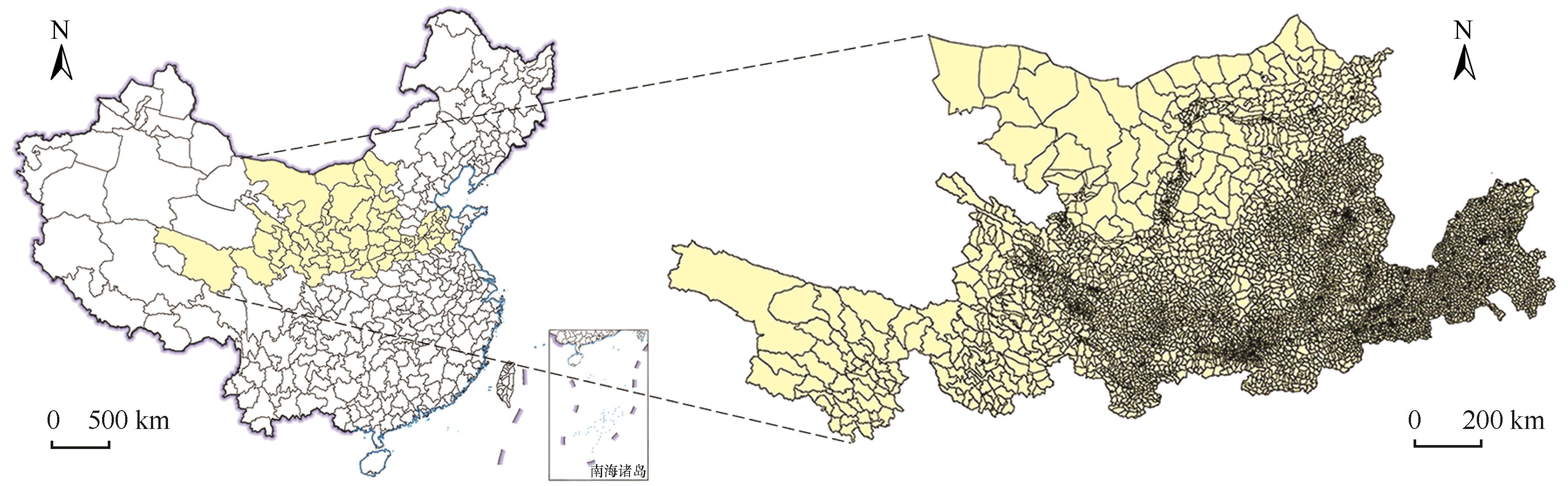
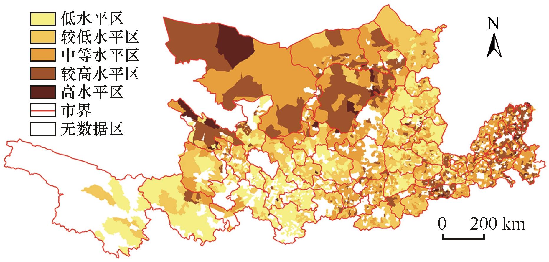
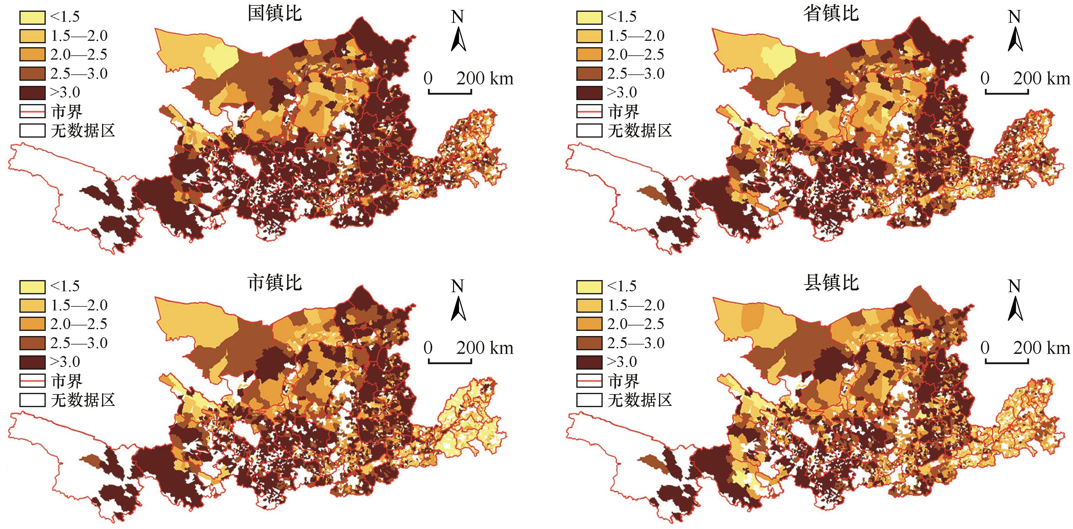
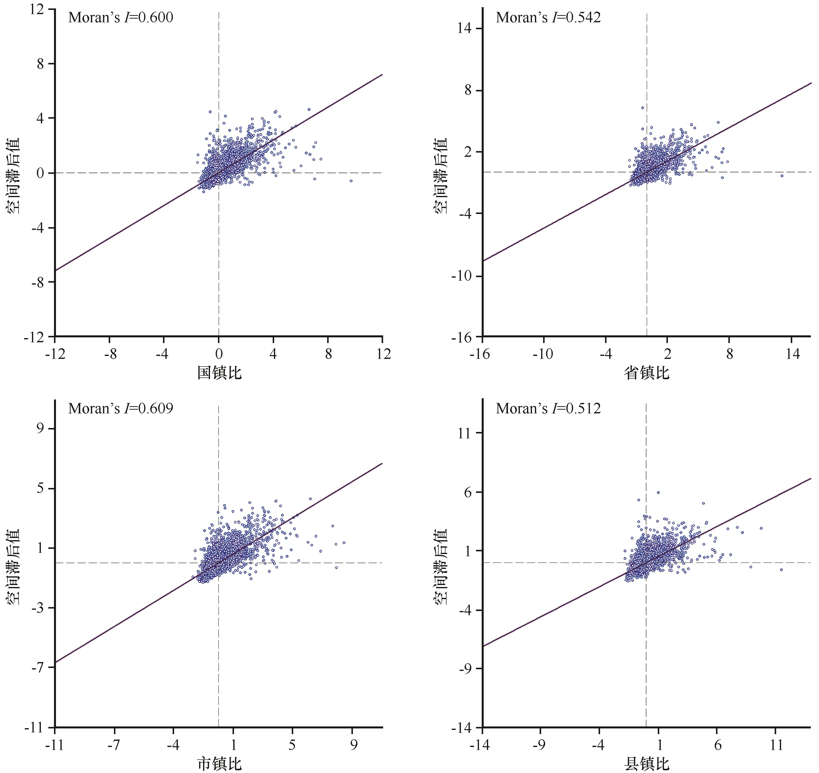
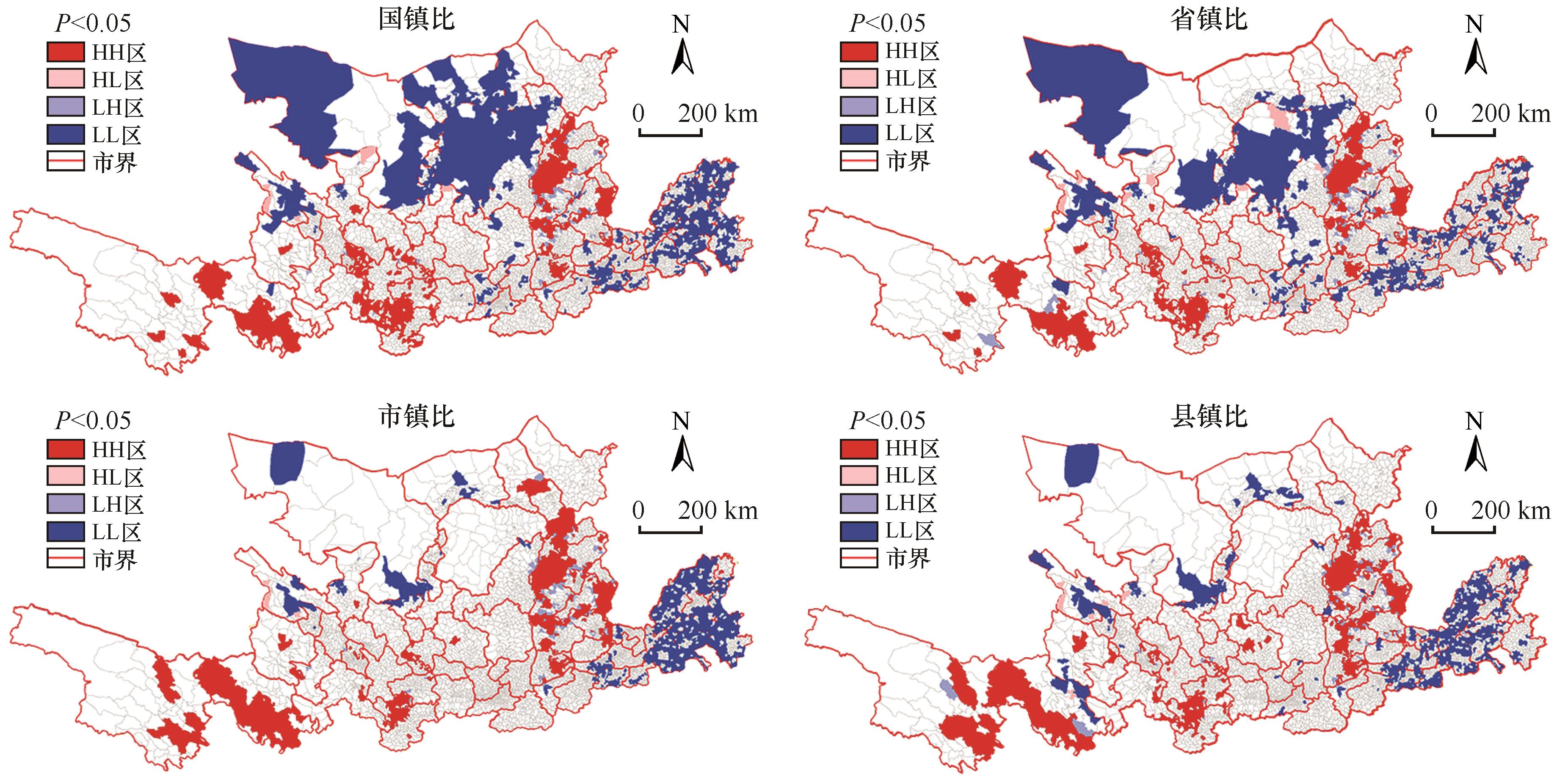
基于城乡融合视角,通过多种渠道搜集镇域农民人均纯收入数据,分析黄河流域镇域经济的空间格局及其影响因素。具体而言,以农民人均纯收入为基础指标,以国镇比(全国城镇居民的平均收入与乡镇农民人均纯收入之比)、省镇比(省域城镇居民的平均收入与乡镇农民人均纯收入之比)、市镇比(市域城镇居民的平均收入与乡镇农民人均纯收入之比)、县镇比(县域城镇居民的平均收入与乡镇农民人均纯收入之比)为城乡融合下的镇域经济测度指标,分析黄河流域7 098个镇域单元组成的经济空间格局,进而探讨其影响因素。结果表明:(1)从国镇比下的城乡融合水平看,大多数地区的城乡收入差距较大,表明流域整体的城乡融合水平普遍较低。从空间分布看,低融合水平区主要分布在内蒙古以南、河南以西的广大地区并形成连绵集聚片区,高融合水平区主要分布在山东大部、河南中部及西部、内蒙古局部。省镇比、市镇比、县镇比下的空间分异格局与国镇比保持较高的一致性,不同的是随着参照指标的进一步缩小,各水平区集聚的程度有所弱化。(2)从空间关联格局看,国镇比、省镇比、县镇比下城乡融合发展水平的空间集聚效应明显,主要以显著高-高(HH)区、显著低-低(LL)区为关联类型。国镇比下的显著LL区分布在山东大部、河南中部及北部、内蒙古局部,而显著HH区集中出现在山西外围、甘肃、青海南部。(3)基于最小二乘法、空间滞后模型、空间误差模型等定量分析发现,整体分异格局主要受二三产业从业人员、建镇区人口占比、人均工业产值、二三产业从业人员占比的影响最为显著,工业生产总值、建镇区面积占比仅起基础性影响。

关键词: 镇域经济, 城乡融合, 空间格局, 影响因素, 黄河流域

Abstract:

Based on the perspective of urban-rural integration, the data on per capita net income of farmers at town scale were collected through various channels, and regional economic spatial pattern of the eight provinces in the Yellow River Basin was analyzed. In detail, based on the per capita net income of farmers, the urban-rural integrated level based on income ratio of urban-rural residents under the national, province, city and county perspective was analyzed. Based on the construction of the measurement indicators, this paper analyzed the regional economic spatial pattern at township scale by 7 098 towns’ data in the Yellow River Basin, and then explored its influencing factors. The results were shown as follows. Firstly, from the perspective of the urban-rural economic structure of urban-rural integration, there are certain differences in economic spatial pattern in the whole region. The areas with large urban-rural income gap were mainly distributed in the south of Inner Mongolia and west of Henan, the areas with small urban-rural income gaps include most of Shandong, central and Western Henan and parts of Inner Mongolia. Secondly, from the perspective of spatial correlation, the basic spatial pattern of urban-rural integration level was similar at national, provincial, urban, and county level, significant HH areas and significant LL areas were dominant in agglomeration pattern. It was worth mentioning that the spatial integrated pattern by the ratio of the average income of urban residents to the per capita net income of country town ratio showed a significant polarization distribution. The significant LL area was distributed in most of Shandong, central and Northern Henan and part of Inner Mongolia, while the significant HH area was concentrated in the periphery of Shanxi, Gansu and southern Qinghai. Thirdly, based on quantitative analysis of OLS model, spatial lag model and spatial error model, the spatial differentiation pattern was mainly affected by the employment of the secondary and tertiary industries, the proportion of the population in the built-up area, the per capita industrial output value, and the proportion of employees in the secondary and tertiary industries. The proportion of industrial output value and built-up area had little impact on the improvement of economic development level at township scale.

Key words: township economy, urban-rural integration, spatial pattern, influencing factors, Yellow River Basin

中图分类号: