| 1 |
Cai Y,Ke C Q,Li X,et al.Variations of lake Ice phenology on the Tibetan Plateau from 2001 to 2017 based on MODIS Data[J].Journal of Geophysical Research:Atmospheres,2019,124(2):825-843.
|
| 2 |
Cai Y,Ke C,Yao G,et al.MODIS-observed variations of lake ice phenology in Xinjiang,China[J].Climatic Change,2020,158(3/4):575-592.
|
| 3 |
Duguay C R,Prowse T D,Bonsal B R,et al.Recent trends in Canadian lake ice cover[J].Hydrological Processes,2006,20(4):781-801.
|
| 4 |
Magnuson J J,Robertson D M,Benson B J,et al.Historical trends in lake and river ice cover in the northern hemisphere[J].Science,2000,289(5485):1743-1746.
|
| 5 |
Benson B J,Magnuson J J,Jensen O P,et al.Extreme events,trends,and variability in Northern Hemisphere lake-ice phenology (1855-2005)[J].Climatic Change,2012,112(2):299-323.
|
| 6 |
Brown L C,Duguay C R.The response and role of ice cover in lake-climate interactions[J].Progress in Physical Geography:Earth and Environment,2010,34(5):671-704.
|
| 7 |
Ghanbari R N,Bravo H R,Magnuson J J,et al.Coherence between lake ice cover,local climate and teleconnections (Lake Mendota,Wisconsin)[J].Journal of Hydrology (Amsterdam),2009,374(3):282-293.
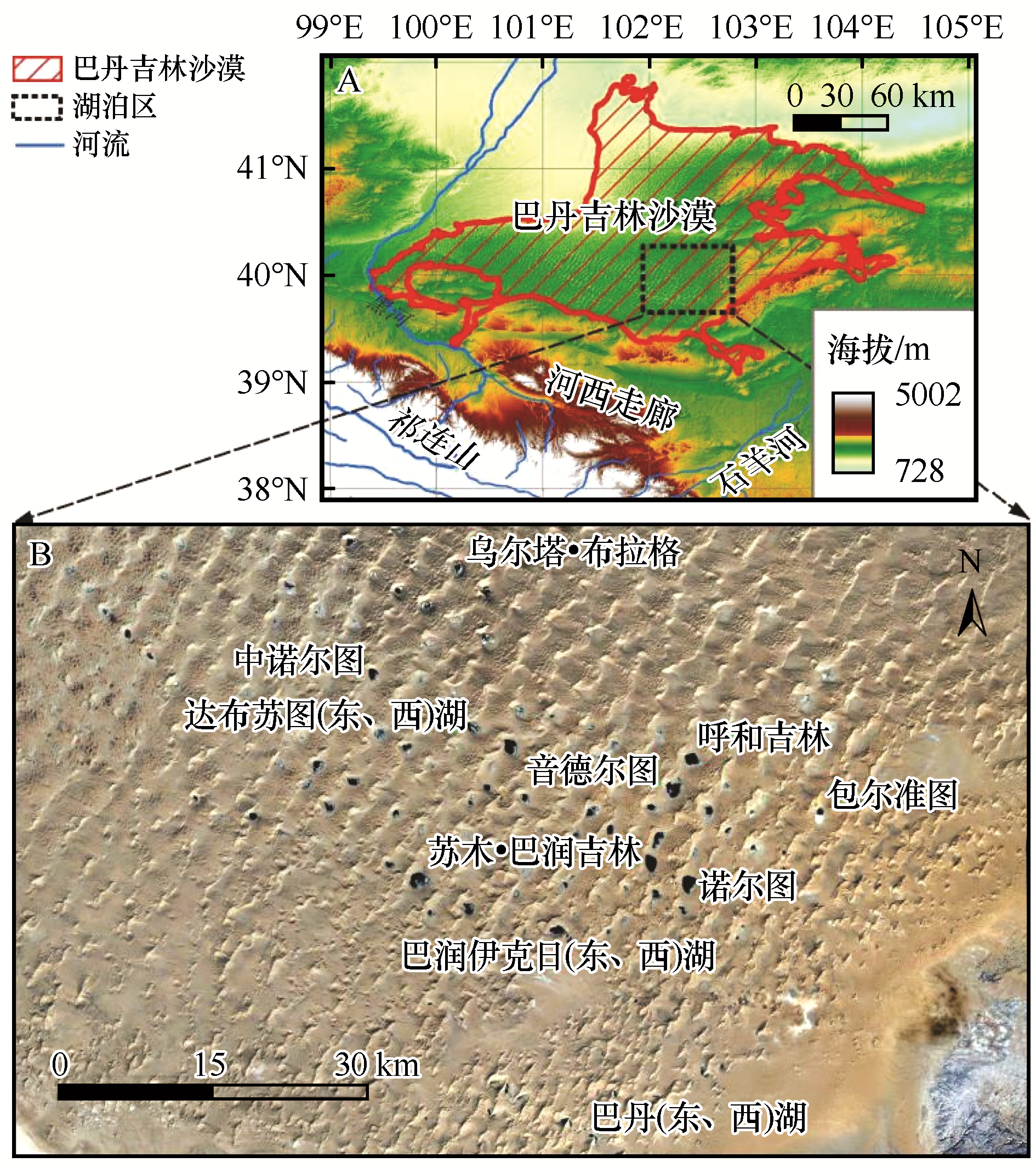
|
| 8 |
Jensen O P,Benson B J,Magnuson J J,et al.Spatial analysis of ice phenology trends across the Laurentian Great Lakes region during a recent warming period[J].Limnology and Oceanography,2007,52(5):2013-2026.
|
| 9 |
Sharma S,Magnuson J J,Mendoza G,et al.Influences of local weather,large-scale climatic drivers,and the ca.11 year solar cycle on lake ice breakup dates, 1905-2004[J].Climatic Change,2013,118(3/4):857-870.
|
| 10 |
Yao X,Li L,Zhao J,et al.Spatial-temporal variations of lake ice phenology in the Hoh Xil region from 2000 to 2011[J].Journal of Geographical Sciences,2016,26(1):70-82.
|
| 11 |
Guo L,Wu Y,Zheng H,et al.Uncertainty and variation of remotely sensed lake ice phenology across the Tibetan Plateau[J].Remote Sensing,2018,10(10):1534.
|
| 12 |
Guo L,Zheng H,Wu Y,et al.Responses of lake ice phenology to climate change at Tibetan Plateau[J].IEEE Journal of Selected Topics in Applied Earth Observations and Remote Sensing,2020,13:3856-3861.
|
| 13 |
Magee M R,Wu C H.Effects of changing climate on ice cover in three morphometrically different lakes[J].Hydrological Processes,2017,31(2):308-323.
|
| 14 |
Sharma S,Blagrave K,Magnuson J J,et al.Widespread loss of lake ice around the Northern Hemisphere in a warming world[J].Nature Climate Change,2019,9(3):227-231.
|
| 15 |
Sharma S,Magnuson J J,Batt R D,et al.Direct observations of ice seasonality reveal changes in climate over the past 320-570 years[J].Scientific Reports,2016,6(1):1-11.
|
| 16 |
Qi M,Liu S,Yao X,et al.Monitoring the Ice Phenology of Qinghai Lake from 1980 to 2018 Using Multisource Remote Sensing Data and Google Earth Engine[J].Remote Sensing,2020,12(14):2217.
|
| 17 |
Qi M,Yao X,Li X,et al.Spatiotemporal characteristics of Qinghai Lake ice phenology between 2000 and 2016[J].Journal of Geographical Sciences,2019,29(1):115-130.
|
| 18 |
Ke C,Tao A,Jin X.Variability in the ice phenology of Nam Co Lake in central Tibet from scanning multichannel microwave radiometer and special sensor microwave/imager:1978 to 2013[J].Journal of Applied Remote Sensing,2013,7(1):73477.
|
| 19 |
Yang Q,Song K,Wen Z,et al.Recent trends of ice phenology for eight large lakes using MODIS products in Northeast China[J].International Journal of Remote Sensing,2019,40(14):5388-5410.
|
| 20 |
朱金峰,王乃昂,陈红宝,等.基于遥感的巴丹吉林沙漠范围与面积分析[J].地理科学进展,2010,29(9):1087-1094.
|
| 21 |
陆莹,王乃昂,李卓仑,等.巴丹吉林沙漠湖泊水化学空间分带性与湖泊面积的等级关系[J].地理研究,2011,30(11):2083-2091.
|
| 22 |
张振瑜,王乃昂,吴月,等.1973-2010年巴丹吉林沙漠腹地湖泊面积空间变化的遥感分析[J].湖泊科学,2013,25(4):514-520.
|
| 23 |
梁晓燕.基于观测的巴丹吉林沙漠湖泊区“暖岛效应”研究[D].兰州:兰州大学,2016.
|
| 24 |
张洵赫,王乃昂,赵力强,等.基于MODIS数据的巴丹吉林沙漠冬季暖岛空间分布特征及其研究[J].兰州大学学报(自然科学版),2015(2):180-185.
|
| 25 |
王乃昂,马宁,陈红宝,等.巴丹吉林沙漠腹地降水特征的初步分析[J].水科学进展,2013,24(2):153-160.
|
| 26 |
Dong C,Wang N,Chen J,et al.New observational and experimental evidence for the recharge mechanism of the lake group in the Alxa Desert,north-central China[J].Journal of Arid Environments,2016,124:48-61.
|
| 27 |
Jiao J J,Zhang X,Wang X.Satellite-based estimates of groundwater depletion in the Badain Jaran Desert,China[J].Scientific Reports,2015,5(1):1-6.
|
| 28 |
Luo X,Jiao J J,Wang X,et al.Groundwater discharge and hydrologic partition of the lakes in desert environment:Insights from stable 18O/2H and radium isotopes[J].Journal of Hydrology,2017,546:189-203.
|
| 29 |
Ma N,Wang N,Zhao L,et al.Observation of mega-dune evaporation after various rain events in the hinterland of Badain Jaran Desert,China[J].Chinese Science Bulletin,2014,59(2):162-170.
|
| 30 |
Sun J,Hu W,Wang N A,et al.Eddy covariance measurements of water vapor and energy flux over a lake in the Badain Jaran Desert,China[J].Journal of Arid Land,2018,10(4):517-533.
|
| 31 |
Wen J,Su Z,Zhang T,et al.New evidence for the links between the local water cycle and the underground wet sand layer of a mega-dune in the Badain Jaran Desert,China[J].Journal of Arid Land,2014,6(4):373-377.
|
| 32 |
Wu X,Wang X,Wang Y,et al.Origin of water in the Badain Jaran Desert,China: new insight from isotopes[J].Hydrology and Earth System Sciences,2017,21(9):4419-4431.
|
| 33 |
Zhang X,Wang N A,Xie Z,et al.Water loss due to increasing planted vegetation over the Badain Jaran Desert,China[J].Remote Sensing,2018,10(1):134.
|
| 34 |
王乃昂,宁凯,李卓仑,等.巴丹吉林沙漠全新世的高湖面与泛湖期[J].中国科学:地球科学,2016,46(8):1106-1115.
|
| 35 |
赵力强,张律吕,王乃昂,等.巴丹吉林沙漠湖泊形态初步研究[J].干旱区研究,2018,35(5):1001-1011.
|
| 36 |
陆莹.巴丹吉林沙漠湖泊水化学时空分布特征及其成因初探[D].兰州:兰州大学,2012.
|
| 37 |
Hall D K,Riggs G A,Salomonson V V,et al.MODIS snow-cover products[J].Remote Sensing of Environment,2002,83(1):181-194.
|
| 38 |
Salomonson V V,Appel I.Estimating fractional snow cover from MODIS using the normalized difference snow index[J].Remote Sensing of Environment,2004,89(3):351-360.
|
| 39 |
Hall D K,Riggs G A,Salomonson V V.Development of methods for mapping global snow cover using moderate resolution imaging spectroradiometer data[J].Remote Sensing of Environment,1995,54(2):127-140.
|
| 40 |
Kirillin G,Leppäranta M,Terzhevik A,et al.Physics of seasonally ice-covered lakes:a review[J].Aquatic Sciences,2012,74(4):659-682.
|
 ), 王乃昂1(

 甘公网安备 62010202000688号