img

官方微信

高级检索

中国沙漠 ›› 2021, Vol. 41 ›› Issue (6): 10-20.DOI: 10.7522/j.issn.1000-694X.2021.00070

• • 上一篇    

黄河流域文物保护单位空间分布特征及其影响因素

周成1(), 柳炳华2, 张旭红3(), 田娟1, 周霖4   

  1. 1.山西财经大学,文化旅游学院,山西 太原 030006
    2.山西财经大学,国际贸易学院,山西 太原 030006
    3.西安理工大学 经济与管理学院,陕西 西安 710054
    4.西北师范大学 旅游学院,甘肃 兰州 730070
  • 收稿日期:2021-05-25 修回日期:2021-06-28 出版日期:2021-11-20 发布日期:2021-12-17
  • 通讯作者: 张旭红
  • 作者简介:张旭红(E-mail: zxhhao85@163.com
    周成(1989—),男,山西忻州人,博士,副教授,主要从事黄河流域经济地理、旅游地理研究。E-mail: zhoutravel@163.com
  • 基金资助:
    教育部人文社会科学基金项目(20YJC890050);山西省高等学校科技创新项目(2019L0477);山西省高等学校哲学社会科学研究项目(201803077);山西省社会科学院(山西省人民政府发展研究中心)2021年度规划课题一般项目(YWYB202107)

Spatial distribution characteristics and influencing factors of heritage conservation units in the Yellow River Basin

Cheng Zhou1(), Binghua Liu2, Xuhong Zhang3(), Juan Tian1, Lin Zhou4   

  1. 1.Faculty of Culture and Tourism, Shanxi University of Finance and Economics,Taiyuan 030006,China
    2.Faculty of International Trade, Shanxi University of Finance and Economics,Taiyuan 030006,China
    3.School of Economic and Management,Xi’an University of Technology,Xi’an 710054,China
    4.Tourism College,Northwest Normal University,Lanzhou 730070,China
  • Received:2021-05-25 Revised:2021-06-28 Online:2021-11-20 Published:2021-12-17
  • Contact: Xuhong Zhang

摘要:

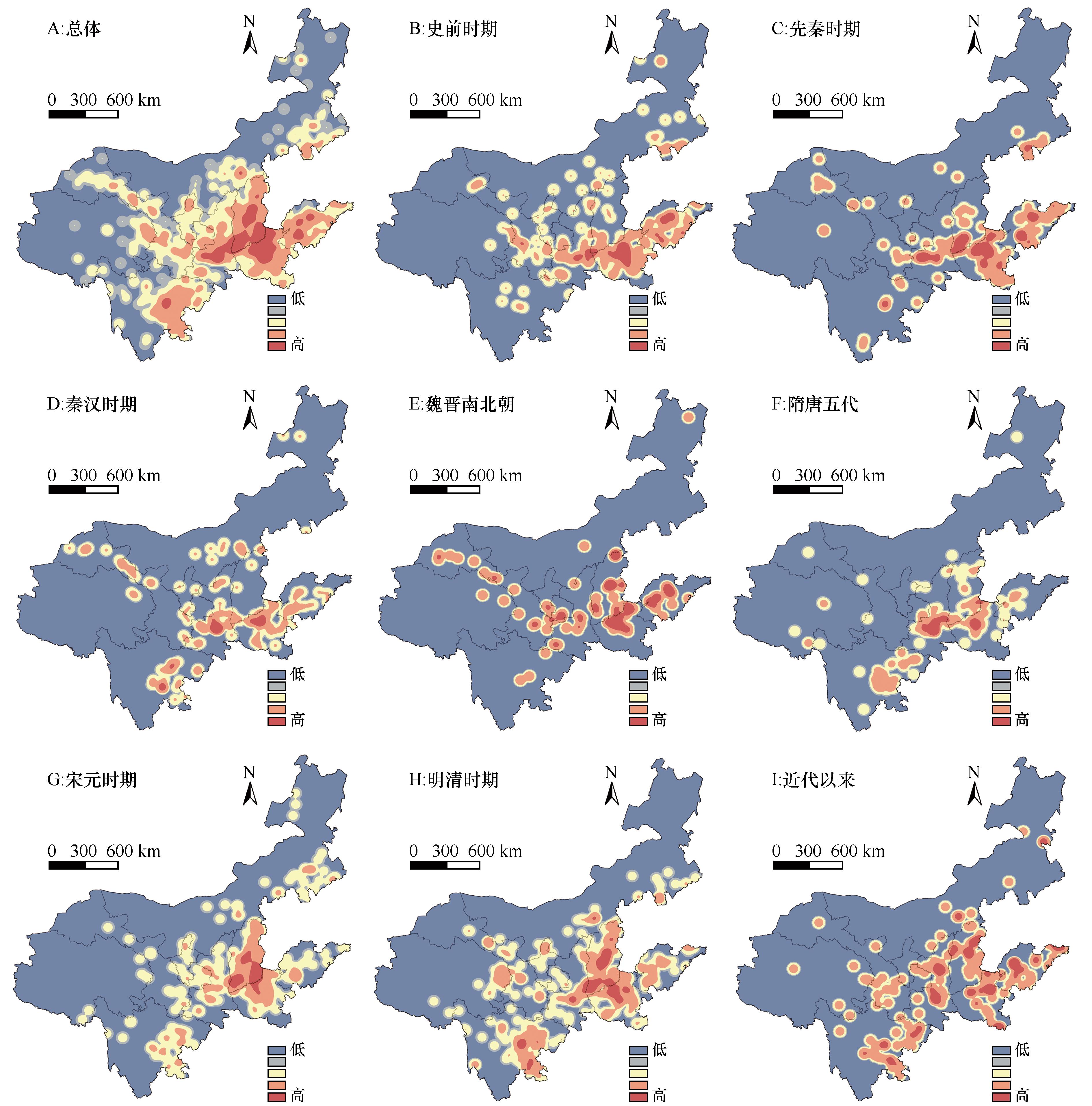
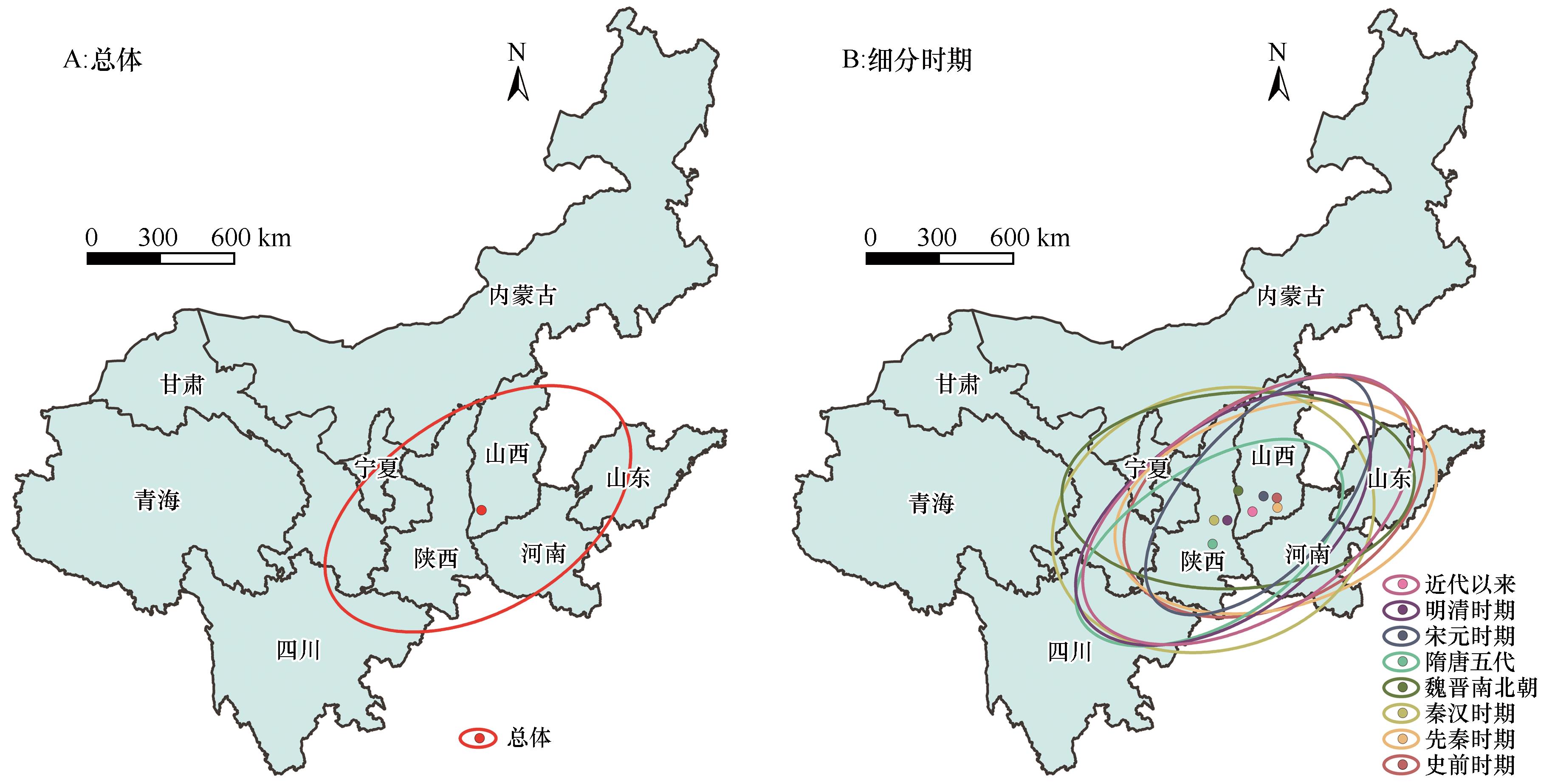
文物保护单位是历史时期区域科技、文化、生产、生活等信息的反映载体。运用核密度估算、最近邻指数、标准差椭圆等方法对黄河流域2 078处国家重点文保单位的空间密度、集散与方向特征给予分析,并运用地理探测器模型探索得出其空间分布的影响因素与交互作用。结果表明:(1)空间密度上,文保单位在黄河流域整体上呈现东密西疏、连片分布的空间特征,核心区数量由史前时期到近代以来呈现波动变化的发展趋势。(2)集散类型上,文保单位的最近临指数为0.38,属于集聚型分布类型。(3)方向特征上,文保单位在黄河流域多呈现东北—西南方向分布,但魏晋南北朝时期旋转角为89.85°,东西横向特征最明显。标准差椭圆重心整体上位于山西省运城市稷山县境内,但从史前时期到近代以来重心轨迹呈现西南—东北往复移动以及山西—陕西交替变化的特征。(4)文化事业经费、河网密度、年末人口数、非遗项目数量和A级景区数量均是黄河流域文保单位空间分布的主导因素,此外,影响因素两两交互作用后多表现出非线性增强或双因子增强型关系,与独立作用时相比更具有空间分布的解释力。

关键词: 文物保护单位, 空间特征, 影响因素, 历史时期, 黄河流域

Abstract:

Heritage conservation units are the carriers reflecting the regional information of science and technology, culture, production and life in historical period, so it is of great significance to study them systematically. Using the methods of nuclear density estimation, nearest neighbor index, standard deviation ellipse and geographic detector, this paper studies the spatial distribution characteristics and influencing factors of 2 078 national key heritage conservation units in the Yellow River Basin. The results show that: (1) In terms of spatial density, the heritage conservation units in the Yellow River Basin show the spatial characteristics of dense in the east, sparse in the west and contiguous distribution ,and the number of core areas has fluctuated from prehistoric to modern times. (2) In terms of distribution type, the average nearest index of heritage conservation units in the Yellow River Basin is 0.38, which belongs to the agglomeration distribution type. (3) In terms of direction, distribution characteristics of heritage conservation units in many historical periods is northeast to southwest, but the east-west characteristic is more obvious in the period of Wei-Jin and Northern-Southern Dynasties, and the rotation angle is 89.85. As a whole, the gravity center of the standard deviation ellipse is located in Jishan County of Yuncheng, Shanxi Province, but from the prehistoric period to modern times, the trajectory of the gravity center shows the characteristics of reciprocating movement from southwest to northeast and alternating changes from Shanxi to Shaanxi Province. (4) In terms of influencing factors, the funds for cultural undertakings, density of river network, year-end population, intangible cultural heritage projects and A-level scenic spots are all the leading influencing factors of spatial distribution of heritage conservation units in the Yellow River Basin. In addition, the interaction of factors shows the relationship of nonlinear enhancement or double factor enhancement, which has more explanatory power of spatial distribution than that in the independent interaction.

Key words: heritage conservation units, spatial characteristics, influencing factors, historical period, the Yellow River Basin

中图分类号: