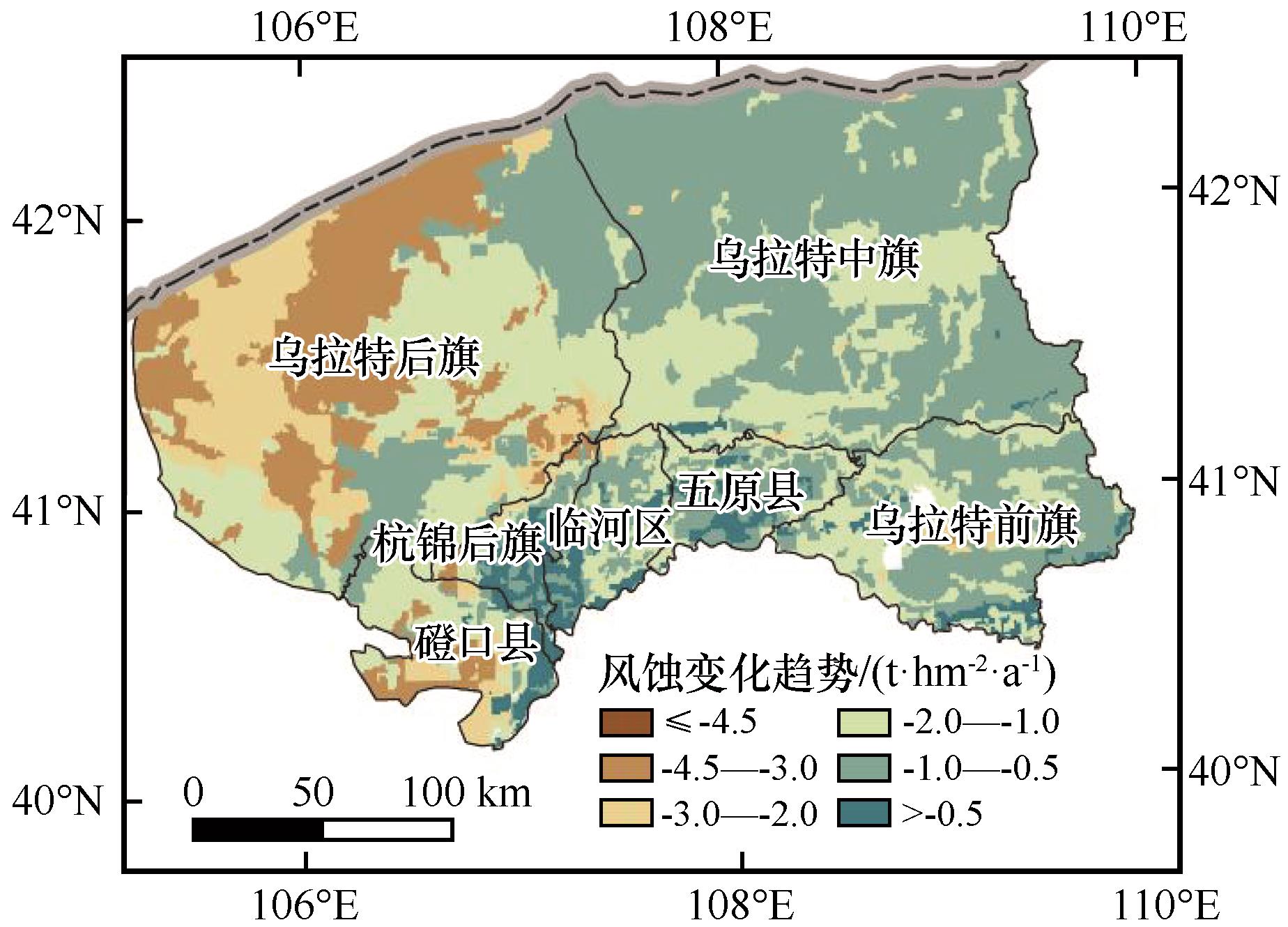
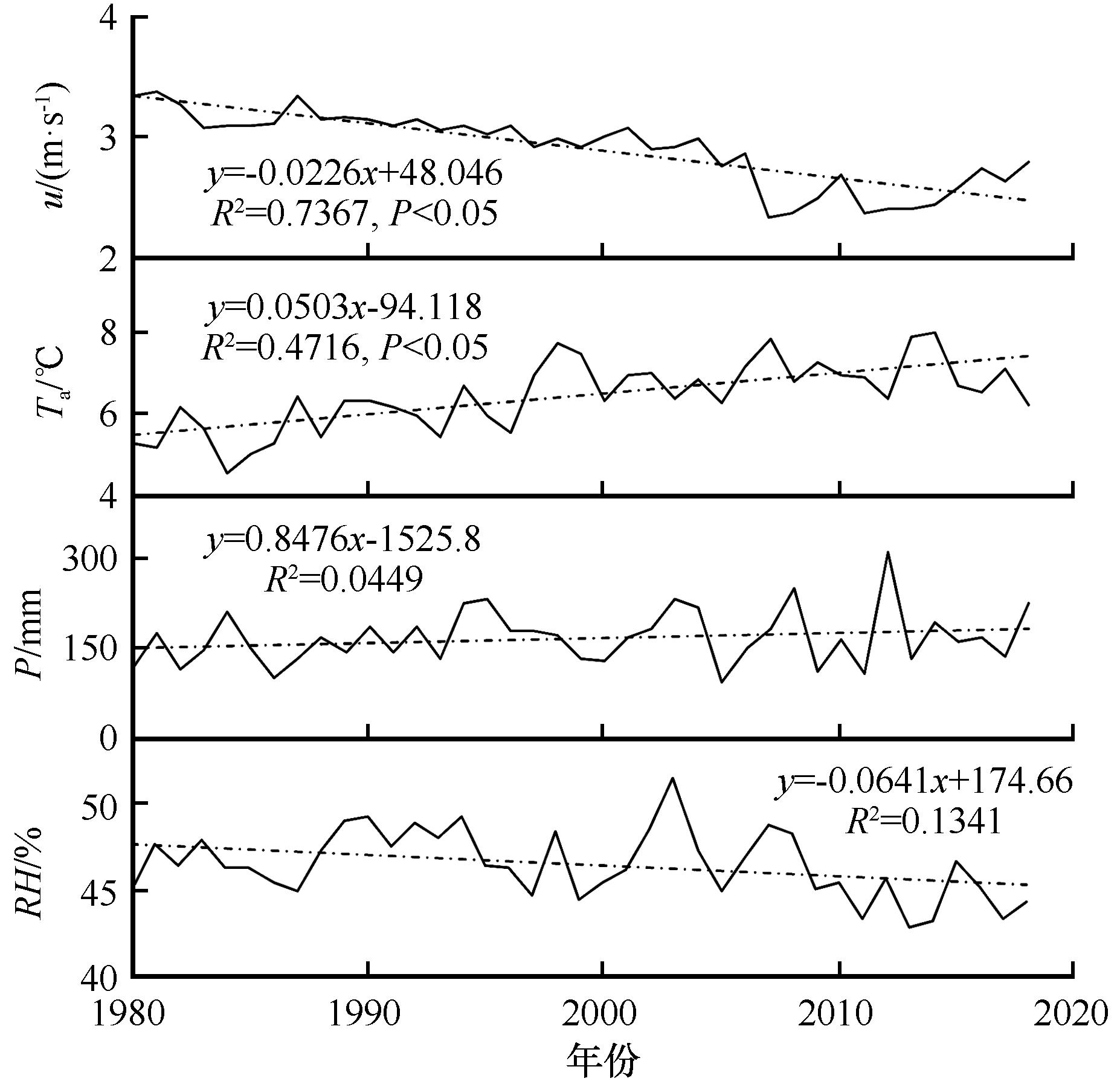
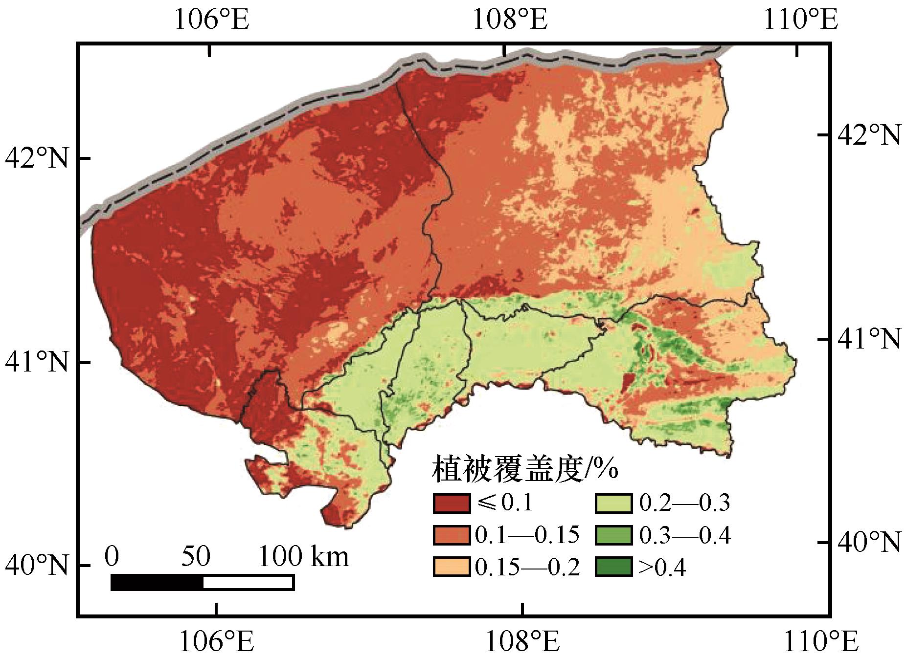
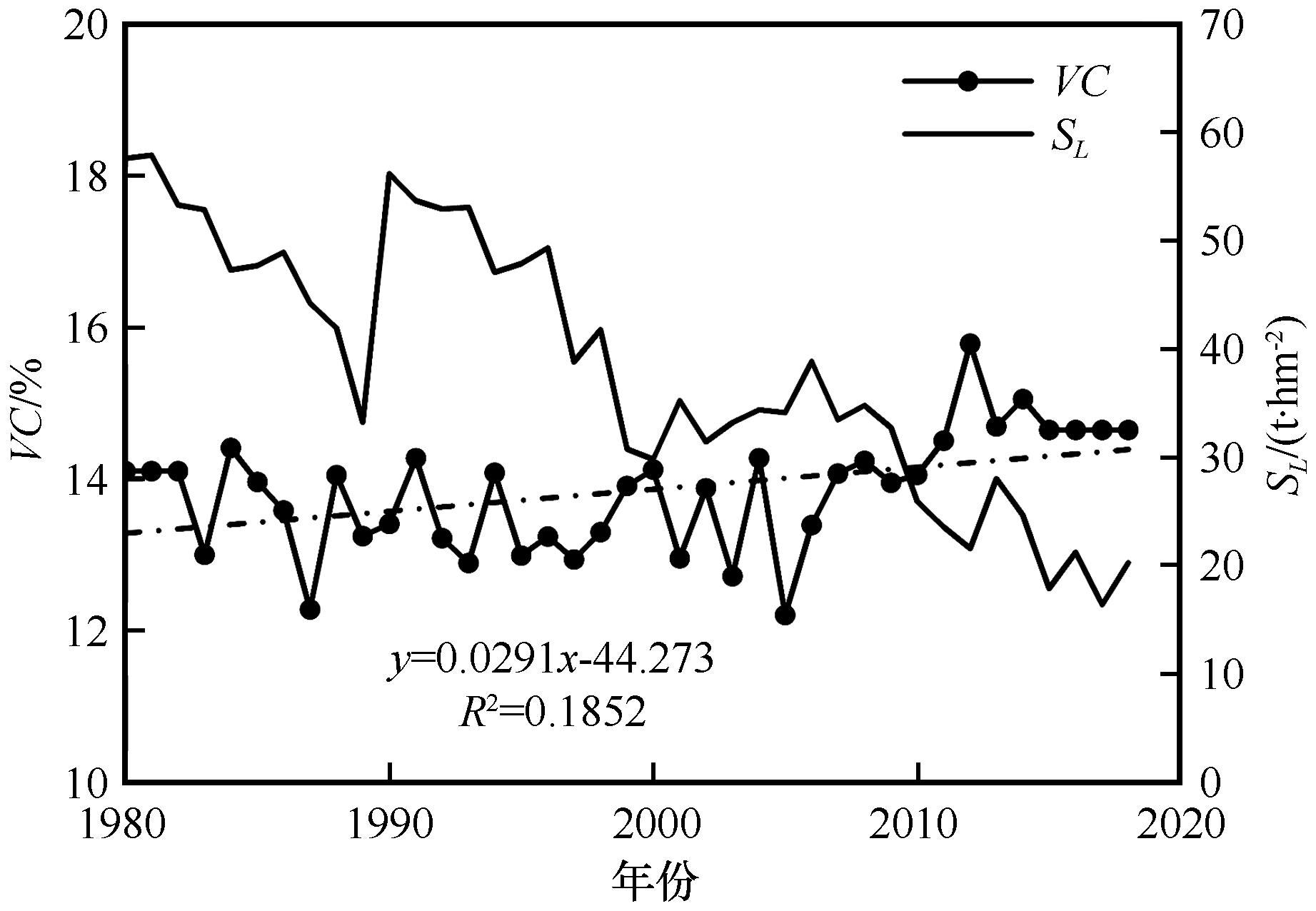
| 1 |
Řeháček D,Khel T,Kučera J,et al.Effect of windbreaks on wind speed reduction and soil protection against wind erosion[J].Soil and Water Research,2017,12(2):128-135.
|
| 2 |
Meng Z G,Dang X B,Gao Y,et al.Interactive effects of wind speed,vegetation coverage and soil moisture in controlling wind erosion in a temperate desert steppe,Inner Mongolia of China[J].Journal of Arid Land,2018,10(4):534-547.
|
| 3 |
曹月娥,吴芳芳,张婷婷,等.基于风蚀模型的准东地区土壤风蚀研究[J].干旱区资源与环境,2018,32(3):94-99.
|
| 4 |
巩国丽,刘纪远,邵全琴.基于RWEQ的20世纪90年代以来内蒙古锡林郭勒盟土壤风蚀研究[J].地理科学进展,2014,33(6):825-834.
|
| 5 |
邢春燕,郭中领,常春平,等.RWEQ模型在河北坝上地区的适用性[J].中国沙漠,2018,38(6):1180-1192.
|
| 6 |
Fryrear D W,Stout J E,Hagen L J,et al.Wind erosion:field measurement and analysis[J].Transactions of the American Society of Agricultural Engineers,1991,34(1):155-160.
|
| 7 |
齐永青,刘纪远,师华定,等.蒙古高原北部典型草原区土壤风蚀的137Cs示踪法研究[J].科学通报,2008,53(9):1070-1076.
|
| 8 |
孙喜军,杨明义,张风宝,等.利用风洞实验研究7Be示踪估算土壤风蚀速率的可行性[J].水土保持学报,2012,26(3):22-25,29.
|
| 9 |
Zhang G F,Azorin-Molina C,Shi P J,et al.Impact of near-surface wind speed variability on wind erosion in the eastern agro-pastoral transitional zone of Northern China,1982-2016[J].Agricultural and Forest Meteorology,2019,271:102-115.
|
| 10 |
Woodruff N P,Siddoway F H.A Wind erosion equation[J].Proceedings of the Soil Science Society of America,1965,29(5):602-608.
|
| 11 |
Gregory J M,Borrelli J,Fedler C B.TEAM:Texas erosion analysis model[C]//Proceedings of 1988 Wind Erosion Conference.Lubbock,Texas,USA:Texas Technical University,1988:88-103.
|
| 12 |
Bacharov A P.A Description of Devices Used in the Study of Wind Erosion of Soils[M].Boca Raton,USA:CRC Press,1984.
|
| 13 |
Fryrear D W,Bilbro J D,Saleh A,et al.RWEQ:Improved wind erosion technology[J].Journal of Soil and Water Conservation,2000,55(2):183-189.
|
| 14 |
Hagen L J.Evaluation of the wind erosion prediction system (WEPS) erosion submodel on cropland fields[J].Environmental Modelling and Software,2004,19(2):171-176.
|
| 15 |
巩国丽,黄麟.RWEQ模型中土壤结皮和可蚀性因子的改进和应用[J].水土保持通报,2018,38(2):271-274.
|
| 16 |
王洋洋,肖玉,谢高地,等.基于RWEQ的宁夏草地防风固沙服务评估[J].资源科学,2019,41(5):980-991.
|
| 17 |
吴晓光,姚云峰,迟文峰,等.1990-2015年内蒙古高原土壤风蚀时空差异特征[J].中国农业大学学报,2020,25(3):117-127.
|
| 18 |
申陆,田美荣,高吉喜.基于RWEQ模型的浑善达克沙漠化防治生态功能区土壤风蚀与主要影响因子分析[J].水土保持研究,2016,23(6):90-97.
|
| 19 |
张彪,李庆旭,王爽,等.京津风沙源区防风固沙功能的时空变化及其区域差异[J].自然资源学报,2019,34(5):1041-1053.
|
| 20 |
江凌,肖燚,欧阳志云,等.基于RWEQ模型的青海省土壤风蚀模数估算[J].水土保持研究,2015,22(1):21-32.
|
| 21 |
中华人民共和国水利部.土壤侵蚀分类分级标准()[S].北京:中国水利水电出版社,2008.
|
| 22 |
勒斯木初.1980-2015年西北地区土壤风蚀评估与防风固沙服务流研究[D].西安:长安大学,2019.
|
| 23 |
张雪松,闫艺兰,胡正华.不同时间尺度农田蒸散影响因子的通径分析[J].中国农业气象,2017,38(4):201-210.
|
| 24 |
孙宝洋,周蕊,王喆,等.黄河内蒙古段土壤风蚀特征模拟[J].中国沙漠,2020,40(4):120-127.
|
| 25 |
迟文峰,白文科,刘正佳,等.基于RWEQ模型的内蒙古高原土壤风蚀研究[J].生态环境学报,2018,27(6):1024-2033.
|
| 26 |
王旭洋,郭中领,常春平,等.中国北方农牧交错带土壤风蚀时空分布[J].中国沙漠,2020,40(1):12-22.
|
| 27 |
Mandakh N,Tsogtbaatar J,Dash D,et al.Spatial assessment of soil wind erosion using WEQ approach in Mongolia[J].Journal of Geographical Sciences,2016,26(4):473-483.
|
| 28 |
Li J Y,Ma X F,Zhang C.Predicting the spatiotemporal variation in soil wind erosion across Central Asia in response to climate change in the 21st century[J].Science of The Total Environment,2020,709:1-12.
|
| 29 |
Mcvicar T R,Roderick M L,Donohue R J,et al.Global review and synthesis of trends in observed terrestrial near-surface wind speeds:Implications for evaporation[J].Journal of Hydrology,2012,416(3):182-205.
|
| 30 |
丁一汇,李霄,李巧萍.气候变暖背景下中国地面风速变化研究进展[J].应用气象学报,2020,31(1):1-12.
|
| 31 |
邢丽珠,张方敏,黄进,等.1961—2018年内蒙古风速变化及影响因素分析[J].干旱区资源与环境,2020,34(11):162-168.
|
| 32 |
芦佳玉,延军平,王鹏涛,等.全球气候变暖背景下陕甘宁地区风速时空变化特征[J].中国沙漠,2017,37(3):554-561.
|
| 33 |
Vigiak O,Sterk G,Warren A,et al.Spatial modeling of wind speed around windbreaks[J].Catena,2003,52:273-288.
|
| 34 |
江凌,肖燚,饶恩明,等.内蒙古土地利用变化对生态系统防风固沙功能的影响[J].生态学报,2016,36(12):3734-3747.
|
| 35 |
曹世雄,刘冠楚,马华.我国三北地区植被变化的动因分析[J].生态学报,2017,37(15):5023-5030.
|
| 36 |
王耀,张昌顺,刘春兰,等.三北防护林体系建设工程区森林水源涵养格局变化研究[J].生态学报,2019,39(16):5847-5856.
|
| 37 |
谢舒笛,莫兴国,胡实,等.三北防护林工程区植被绿度对温度和降水的响应[J].地理研究,2020,39(1):152-165.
|
 ), 张方敏1(
 甘公网安备 62010202000688号