img

官方微信

高级检索

中国沙漠 ›› 2022, Vol. 42 ›› Issue (4): 110-119.DOI: 10.7522/j.issn.1000-694X.2022.00017

• • 上一篇    

科尔沁沙地西部横向沙丘间的风况和输沙势

冯净雪1(), 丁占良2(), 尤莉3, 韩广1   

  1. 1.湖南师范大学 地理科学学院,湖南 长沙 410081
    2.包头师范学院 资源与环境学院,内蒙古 包头 014030
    3.内蒙古自治区气候中心,内蒙古 呼和浩特 010051
  • 收稿日期:2021-12-12 修回日期:2022-02-16 出版日期:2022-07-20 发布日期:2022-08-29
  • 通讯作者: 丁占良
  • 作者简介:丁占良(E-mail: dingzlnm@126.com
    冯净雪(1996—),女,河南焦作人,硕士研究生,主要从事风沙地貌学研究。E-mail: 1454073143@qq.com
  • 基金资助:
    国家自然科学基金面上项目(41271025)

Wind regimes and drift potentials in the corridor of transverse dunefield in western Korqin Sandy Land

Jingxue Feng1(), Zhanliang Ding2(), Li You3, Guang Han1   

  1. 1.School of Geographic Sciences,Hunan Normal University,Changsha 410081,China
    2.School of Resources and Environment,Baotou Normal College,Baotou 014030,Inner Mongolia,China
    3.Inner Mongolia Climate Center,Hohhot 010051,China
  • Received:2021-12-12 Revised:2022-02-16 Online:2022-07-20 Published:2022-08-29
  • Contact: Zhanliang Ding

摘要:

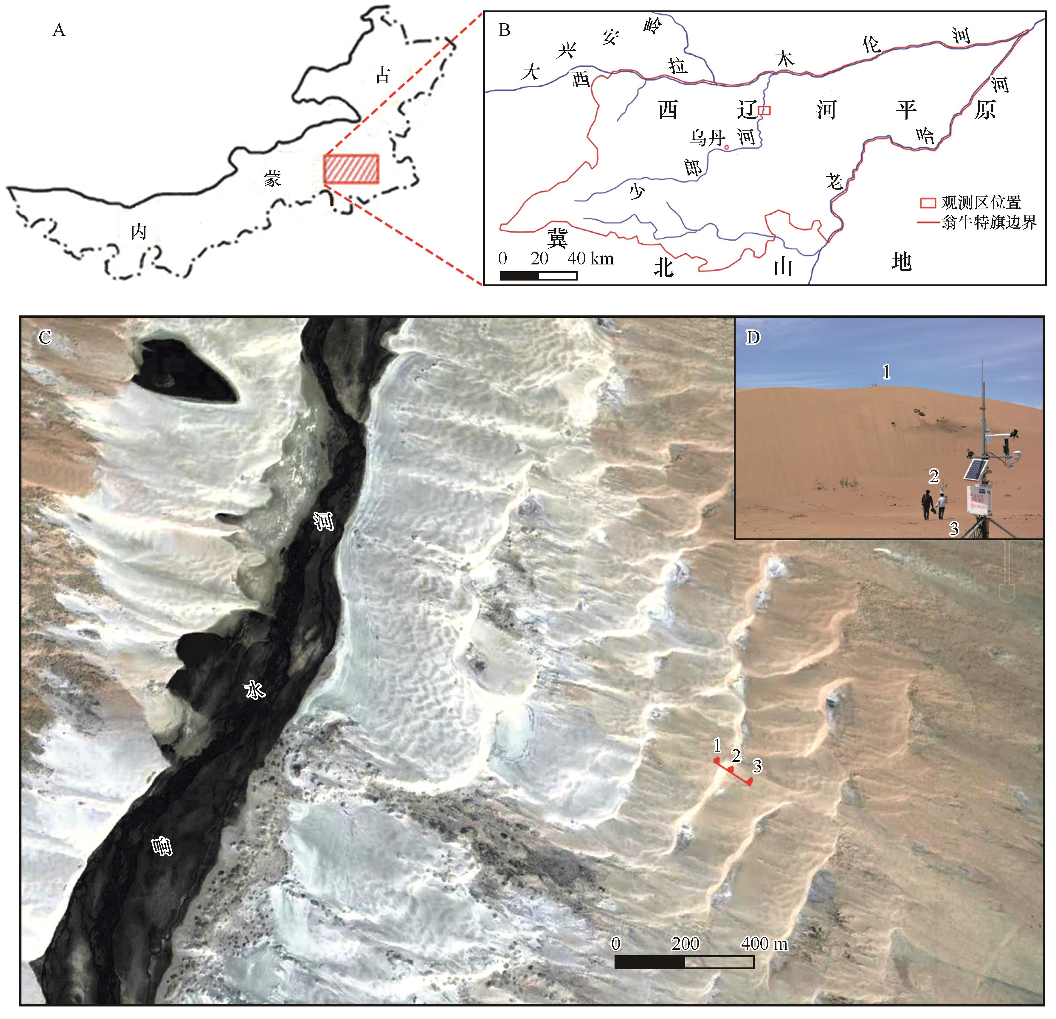
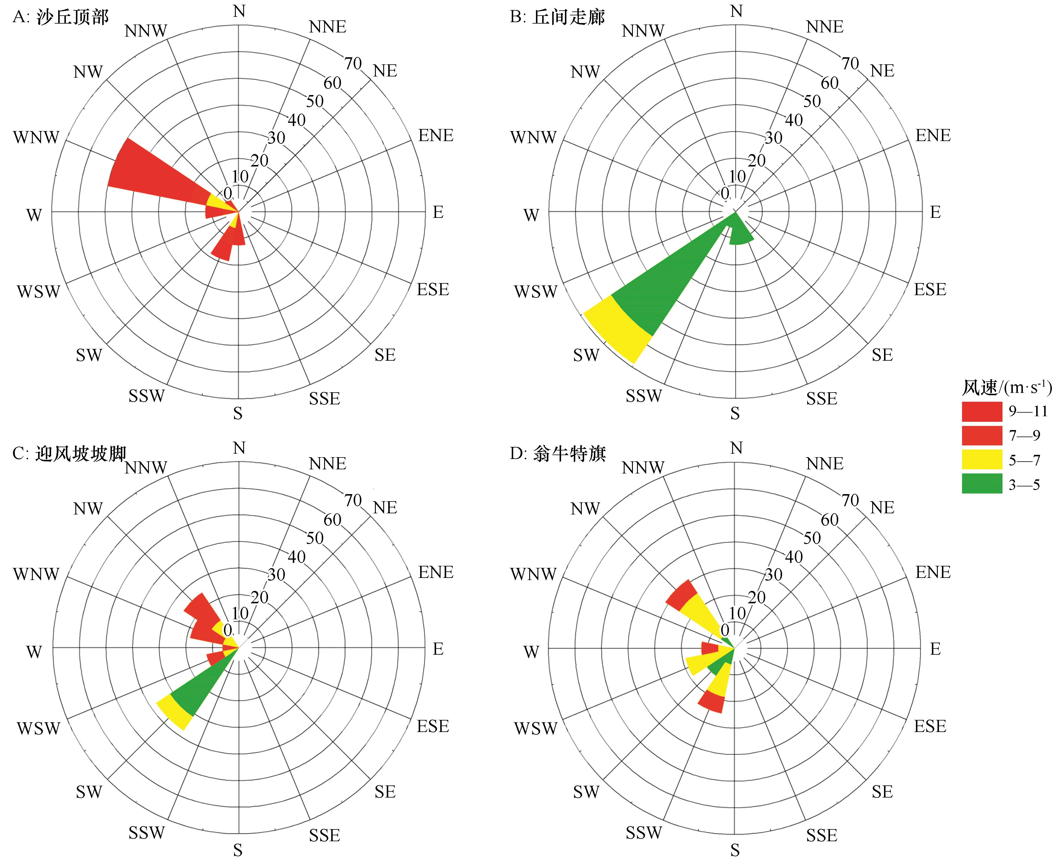
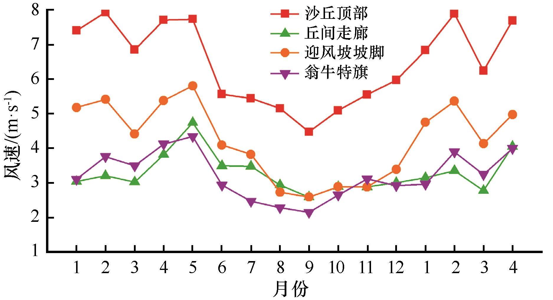
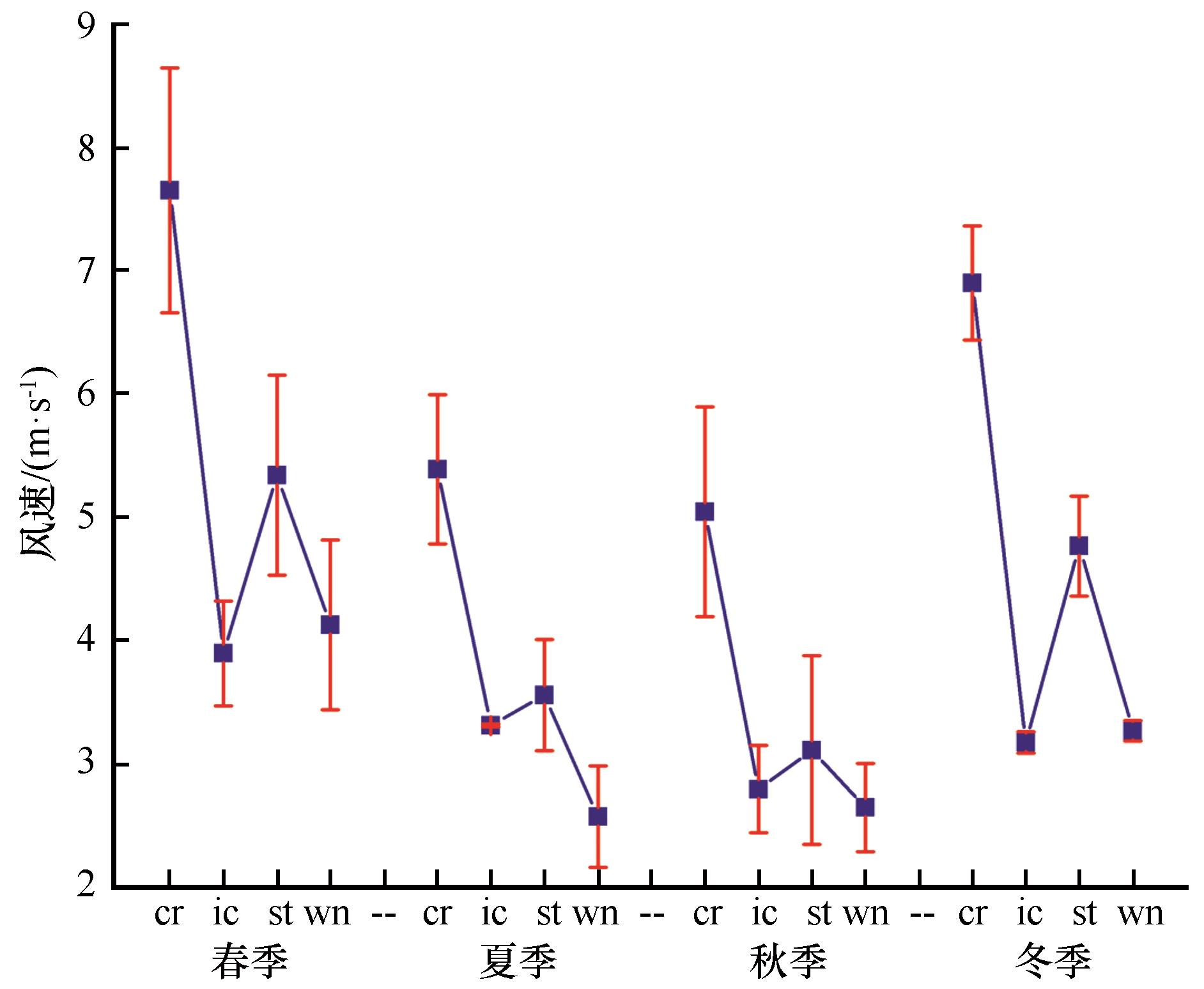
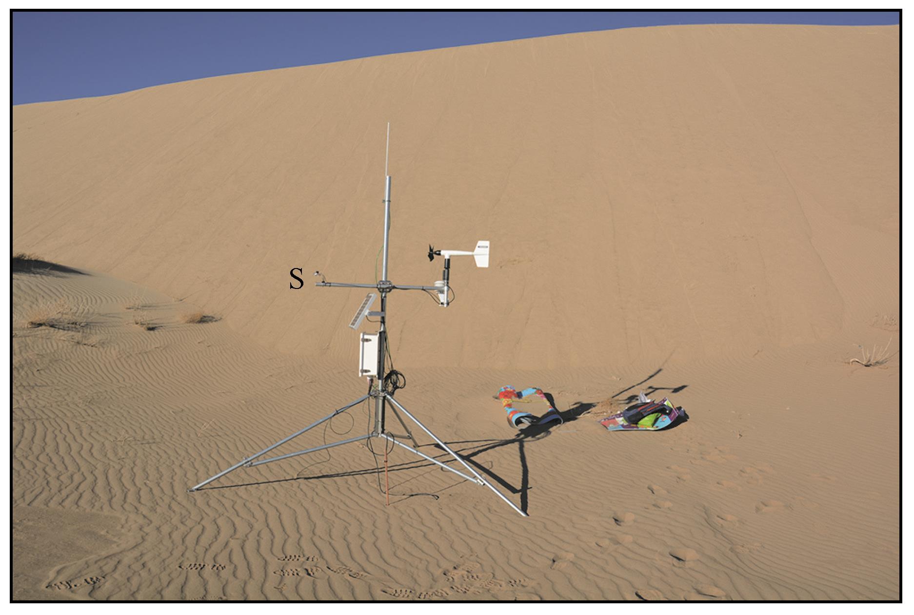
以科尔沁沙地西部一处典型横向沙丘群为研究对象,在沙丘顶部、丘间走廊和迎风坡脚各布设一套自动气象站,对流动性的横向沙丘群内部的风况进行了连续16个月的实地观测。为有效说明沙丘群外围气象站是否能真实反映沙丘群内部实际风况特征,从翁牛特旗国家站获取了同时段风况的小时数据。结果表明:(1)丘间走廊年内主导风向为SW,与迎风坡脚基本一致但频率更高,相对于沙丘顶部(WNW)和翁牛特旗(NW)而言,风向大角度向左偏转;(2)丘间走廊年内平均风速为3.28 m·s-1,春季平均风速可达4.74 m·s-1,瞬时风速大于起沙风速;丘间走廊会发生较强烈的风沙活动,这对塑造丘间走廊完整形态、形成稳定的横向沙丘群空间格局具有重要作用;(3)利用日均值计算丘间走廊的输沙势为37.94 VU,低于沙丘顶部94.54%,高于翁牛特旗86.99%,由此可知,沙丘群外围气象台站测得的风况数据不能真实反映沙丘群内部风沙活动的实际情况。为更精确地估算沙丘群内部的真实输沙状况,建议至少在沙丘顶部和丘间走廊各布设一套全自动气象站进行联动观测。本研究对于揭示沙丘群落整体风况变化规律和沙尘灾害防治具有重要的理论和技术支撑价值。

关键词: 横向沙丘群, 风况, 主导风向, 输沙势, 科尔沁沙地

Abstract:

In this paper, a typical transverse dunefield in the western parts of the Korqin Sandy Land was selected as study area, and a series of automatic meteorological stations were installed at the summit, the interdune corridor and the lower stoss to observe the wind conditions inside the mobile transverse dunefield for 16 consecutive months in the field. To effectively illustrate whether the nearby weather stations can truly reflect the actual wind characteristics inside the dunefield, the hourly average data of wind regimes for the same period were obtained from the Wengniut Banner National Meteorological Station. The results show that: (1) the dominant wind direction in the corridor during the year is SW, which is basically the same as the stoss but with higher frequency, and the wind direction is deflected to the left at a large angle compared with the summit (WNW) and Wengniut Banner (NW); (2) the average wind speed in the corridor during the year is 3.28 m?s-1, and the average wind speed in spring can reach 4.74 m?s-1, and the instantaneous wind speed is greater than the local threshold speed; the corridor has stronger wind and sand activities at this time, which plays an important role in shaping the complete form of the corridor and forming a stable spatial pattern of dunefield; (3) the sand transport potential of corridor is 37.94 VU, which is lower than the summit by 94.54% and higher by 86.99% than Wengniut Banner, thus it can be seen that the wind data measured by the nearby meteorological station cannot truly reflect the actual situation of wind and sand activities inside the dunefield; (4) in order to estimate the real situation of sand transport inside the dunefield more accurately, it is recommended to deploy at least one set of automatic meteorological station at the summit and another at the corridor for joint observations. This study has important theoretical and technical support value for revealing the overall wind condition change pattern of dunefield and sand disaster prevention and control.

Key words: transverse dunefield, wind regime, dominant wind, drift potential, Korqin Sandy Land

中图分类号: