img

官方微信

高级检索

中国沙漠 ›› 2026, Vol. 46 ›› Issue (3): 353-361.DOI: 10.7522/j.issn.1000-694X.2025.00244

• • 上一篇    

内蒙古鄂尔多斯西柳沟流域生态系统服务功能空间格局与变化解析

韩艳1,2(), 乔荣荣2,3, 常学礼2()   

  1. 1.潍坊中学,山东 潍坊 261031
    2.鲁东大学 资源与环境工程学院,山东 烟台 264025
    3.南京大学 生命科学学院,江苏 南京 210023
  • 收稿日期:2025-03-30 修回日期:2025-10-21 出版日期:2026-05-20 发布日期:2026-06-11
  • 通讯作者: 常学礼
  • 作者简介:韩艳(1986—),女,山东潍坊人,硕士,主要从事土地利用变化监测研究。E-mail: 872766920@qq.com
  • 基金资助:
    内蒙古自治区“十三五”水利重大专项(NSK2017-M2);国家自然科学基金项目(41271193)

Spatial pattern and changes of ecosystem service functions in the Xiliugou Basin of Ordos, Inner Mongolia

Yan Han1,2(), Rongrong Qiao2,3, Xueli Chang2()   

  1. 1.Weifang Middle School,Weifang 261031,Shandong,China
    2.School of Resources and Environmental Engineering,Ludong University,Yantai 264025,Shandong,China
    3.School of Life Sciences,Nanjing University,Nanjing 210023,China
  • Received:2025-03-30 Revised:2025-10-21 Online:2026-05-20 Published:2026-06-11
  • Contact: Xueli Chang

摘要:

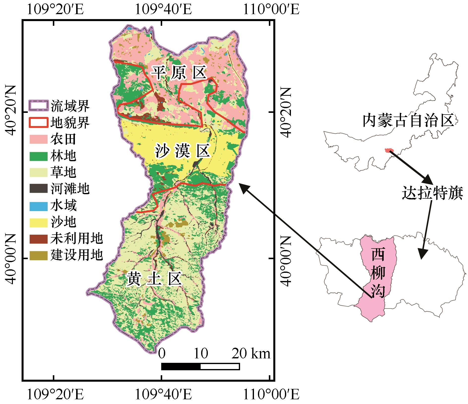
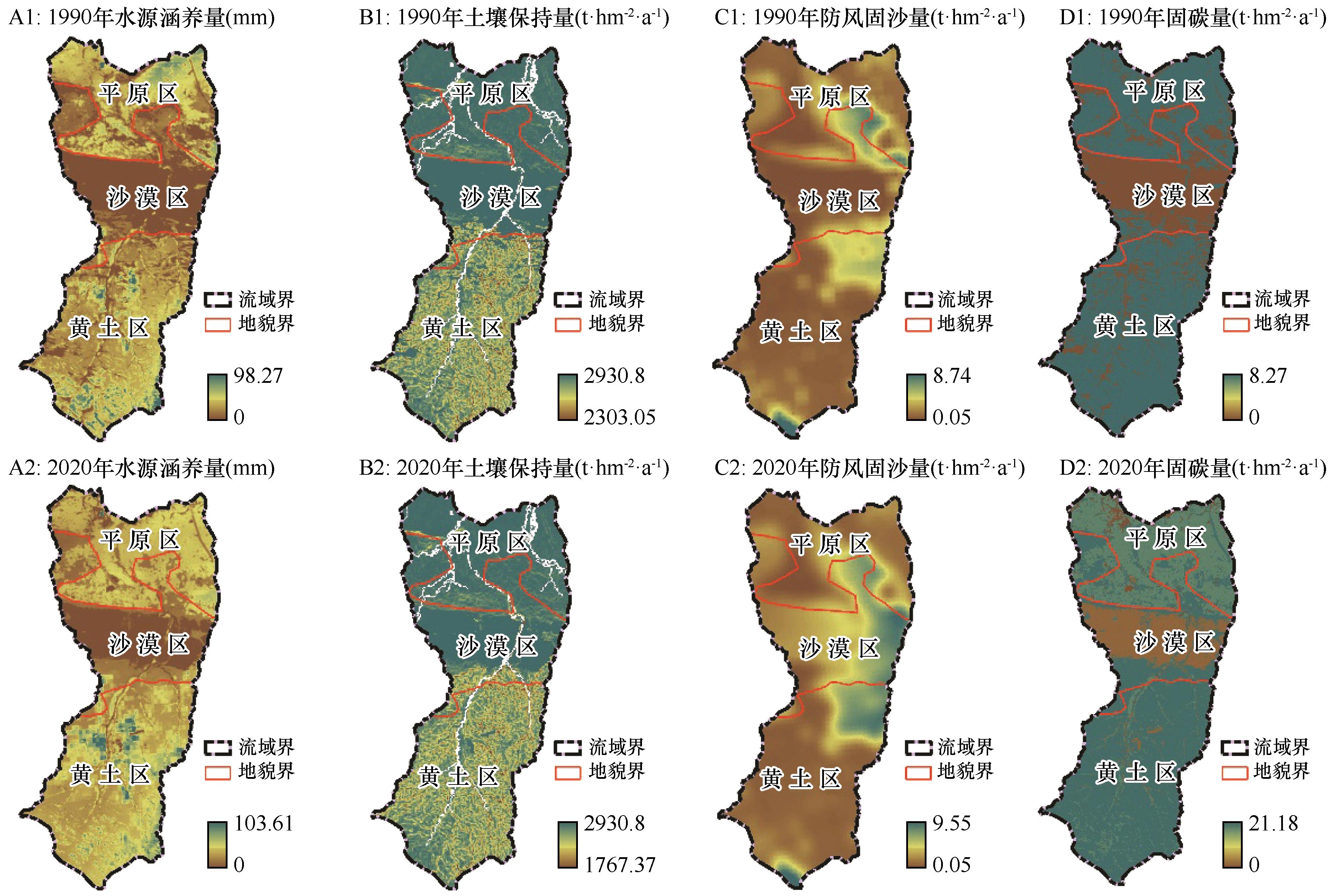
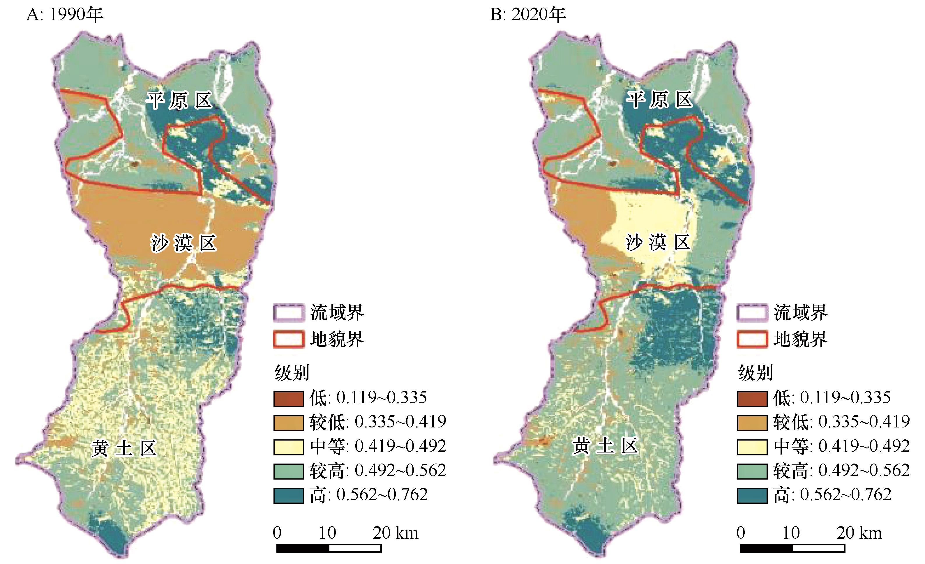
在全球气候变化和人类活动日益加剧的背景下,生态系统服务功能评价成为当前地球科学研究的主要方向,特别是随着InVEST模型与ArcGIS结合的不断完善,针对水源涵养、土壤保持、防风固沙和固碳的生态系统服务功能评价成为区域可持续发展规划的依据。本文采用InVEST模型与ArcGIS的空间分析模块相结合,分析了内蒙古鄂尔多斯西柳沟流域地貌分异对独立和综合生态系统服务功能的影响,解释了近30年来生态系统服务功能变化特点。结果表明:西柳沟地貌类型空间分异对生态系统服务功能有明显影响。1990 —2020年,水源涵养量增加了4.62 mm,其中沙漠区增加幅度最大,为2.55倍;土壤保持量减少了22.62 t·hm-2·a-1,其中黄土区减少最多,为30.44 t·hm-2·a-1;防风固沙量增加了1.30 t·hm-2·a-1,其中沙漠区增加最大,为1.7 t·hm-2·a-1;固碳量增加了0.08 t·hm-2·a-1,其中黄土区增加最大,为0.22 t·hm-2·a-1。分级格局综合评价揭示了在不同时间尺度上,较高级别是分布面积最大的类型。空间格局特征以1990年的较低级别在沙漠区集中连片分布和2020年的较高级别在黄土区和平原区呈连片分布为特点,研究区地貌分异导致的变化以黄土区和沙漠区最为显著。总体上高和较高级别面积分别增加了138.1、213.6 t·hm-2·a-1,低、较低和中等级别面积分别减少了7.5、235.0、109.1 t·hm-2·a-1。西柳沟生态系统服务功能变化与近30年来的黄土区水土保持工程实施、草原科学禁牧和库布齐沙漠化治理与开发利用并举等生态工程建设密切相关。

关键词: 生态系统服务, 评价, InVEST模型, 西柳沟

Abstract:

In the context of climate change and increasingly intensive human activities, the evaluation of ecosystem service functions has become one of the primary research directions in Earth sciences. In particular, the continuous improvement of the integration between the InVEST model and ArcGIS has made it possible to assess ecosystem service functions, such as water conservation, soil retention, windbreak and sand fixation, and carbon sequestration. These assessments have become critical references for regional sustainable development planning. This study combines the InVEST model with the spatial analysis module of ArcGIS to analyze the impact of geomorphic differentiation on both independent and integrated ecosystem service functions in the Xiliugou watershed. It also explains changes in the ecosystem service functions over the past three decades. The results showed that: geomorphic type spatial differentiation has a significant impact on ecosystem service functions. Between 1990 and 2020, water conservation increased by 4.62 mm, with the largest increase (2.55 times) occurring in desert areas; soil retention decreased by 22.62 t·hm-2·a-1, with the most significant reduction (30.44 t·hm-2·a-1) observed in loess regions; deposit by windbreak and sand fixation increased by 1.30 t·hm-2·a-1, with the largest increase (1.7 t·hm-2·a-1) in desert areas; and carbon sequestration increased by 0.08 t·hm-2·a-1, with the most notable increase (0.22 t·hm-2·a-1) in loess regions. The comprehensive evaluation pattern analysis revealed that higher-level types occupy the largest distribution areas at different time points. The spatial pattern characteristics of different levels are marked by the concentration of lower-level types in desert areas in 1990 and the concentration of higher-level types in loess and plain areas in 2020. Changes caused by geomorphic differentiation in the study area were most pronounced in loess and desert regions. Overall, high and higher-level areas increased by 138.1 t·hm-2·a-1 and 213.6 t·hm-2·a-1, respectively, while low, lower, and medium-level areas decreased by 7.5 t·hm-2·a-1, 235.0 t·hm-2·a-1, and 109.1 t·hm-2·a-1, respectively. The changes in ecosystem service functions in the Xiuliugou watershed are closely related to ecological engineering projects implemented over the past three decades, including soil and water conservation efforts with scientific rotational grazing in the loess area, and integrated management and utilization of Kubuqi desertification.

Key words: ecosystem services, assessment, InVEST model, Xiliugou

中图分类号: