| 1 |
Hall L S, Krausman P R, Morrison M L.The habitat concept and a plea for standard terminology[J].Wildlife Society Bulletin,1997,25:173-182.
|
| 2 |
杨洁,谢保鹏,张德罡.黄河流域生境质量时空演变及其影响因素[J].中国沙漠,2021,41(4):12-22.
|
| 3 |
Maes J, Paracchini M L, Zulian G,et al.Synergies and trade-offs between ecosystem service supply,biodiversity,and habitat conservation status in Europe[J].Biology Conservation,2012,155:1-12.
|
| 4 |
Li C J, Fu B J, Wang S,et al.Drivers and impacts of changes in China's drylands[J].Nature Reviews Earth & Environment,2021,2:858-873.
|
| 5 |
邓晓红,宋玉琳,李宗省,等.河西地区生态敏感性演变格局及分区治理[J].中国沙漠,2023,43(5):232-240.
|
| 6 |
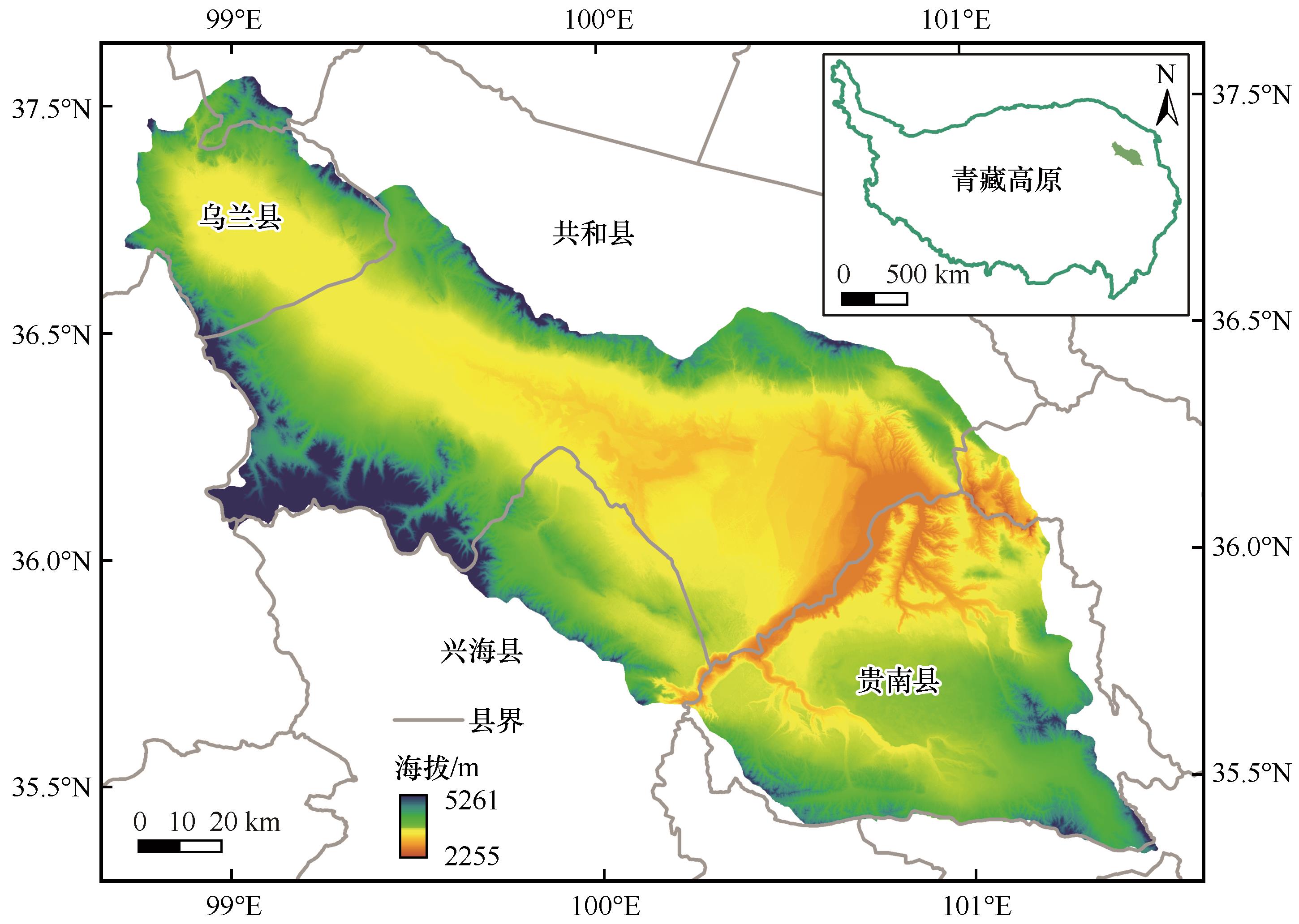
Wu J Y, Luo J G, Zhang H,et al.Projections of land use change and habitat quality assessment by coupling climate change and development patterns[J].Science of The Total Environment,2022,847:157491.
|
| 7 |
刘旻霞.敦煌西湖自然保护区生物多样性特征及生境质量评价[J].干旱区资源与环境,2009,23(3):171-175.
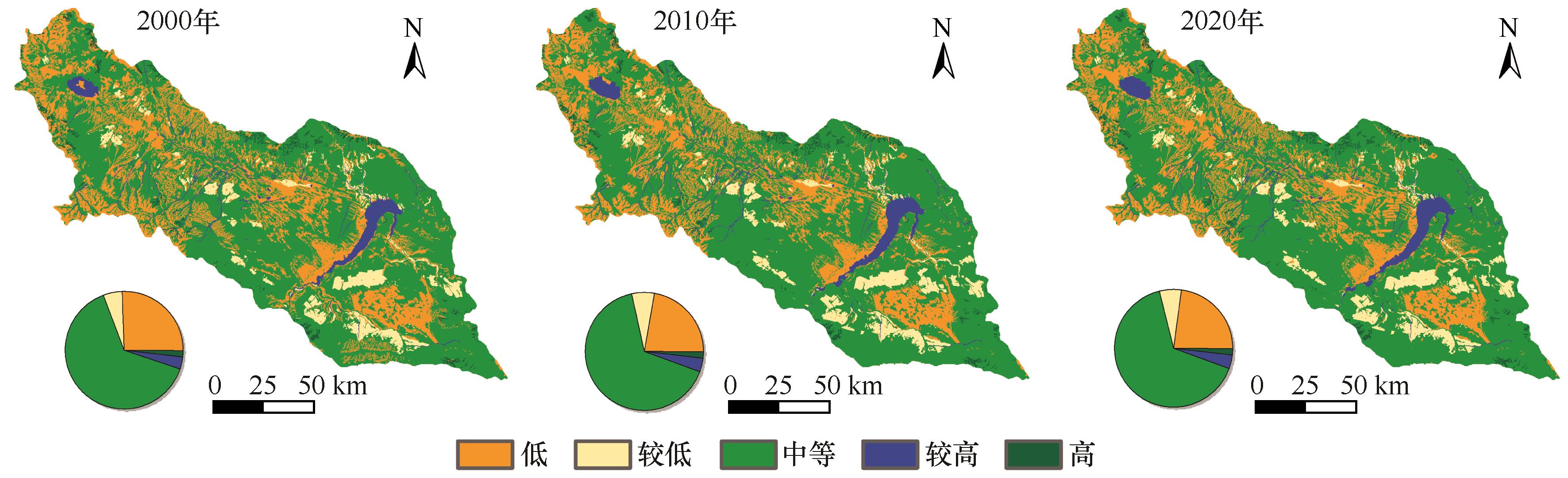
|
| 8 |
Wang B X, Cheng W M.Effects of land use/cover on regional habitat quality under different geomorphic types based on InVEST model[J].Remote Sensing,2022,14:1279.
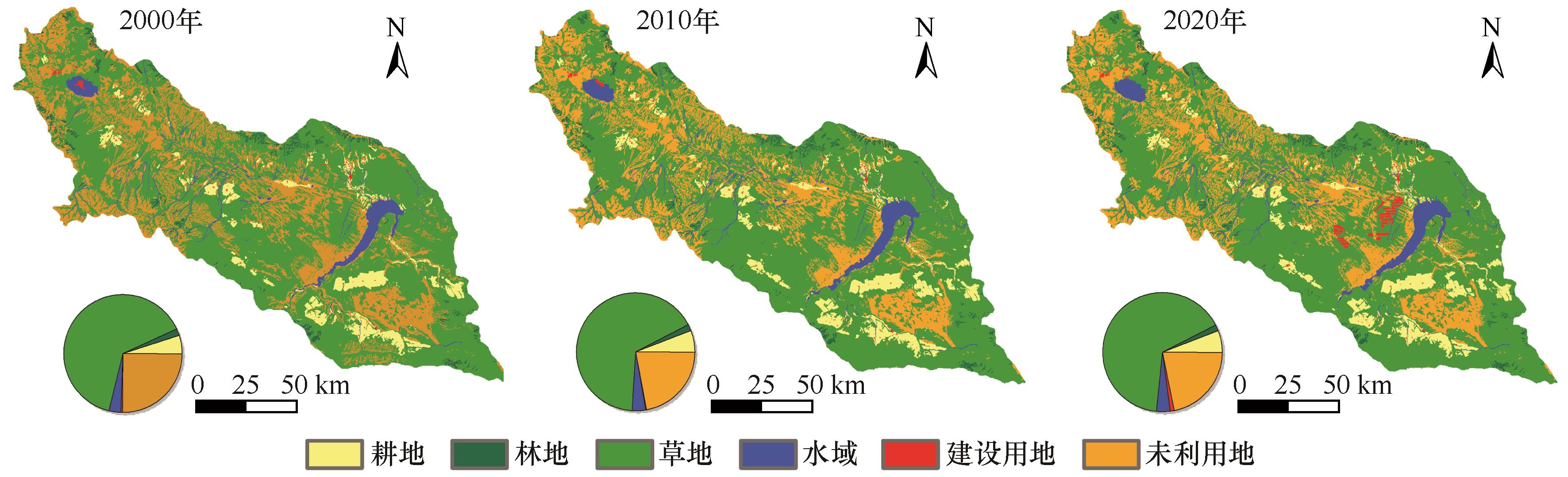
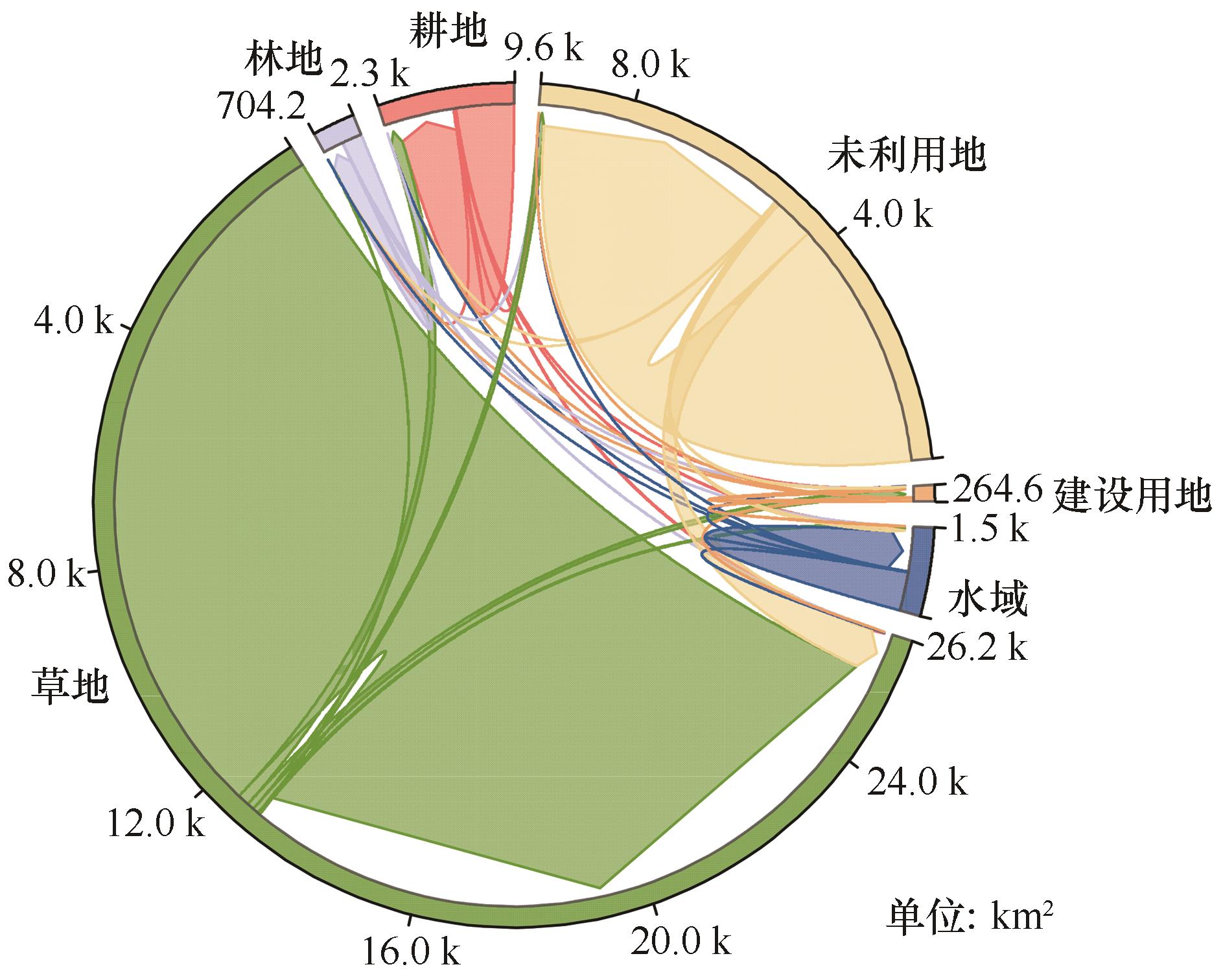
|
| 9 |
Tang F, Fu M C, Wang L,et al.Land-use change in Changli County,China:predicting its spatio-temporal evolution in habitat quality[J].Ecological Indicators,2020,117:106719.
|
| 10 |
Yang Y Y.Evolution of habitat quality and association with land-use changes in mountainous areas:a case study of the Taihang Mountains in Hebei Province,China[J].Ecological Indicators,2021,129:107967.
|
| 11 |
乔治,蒋玉颖,贺曈,等.土地利用变化模拟研究进展[J].生态学报,2022,42(2):5165-5176.
|
| 12 |
Liang X, Guan Q F, Clarke K C,et al.Understanding the drivers of sustainable land expansion using a patch-generating land use simulation (PLUS) model:a case study in Wuhan,China[J].Computers,Environment and Urban Systems,2021,85:101569.
|
| 13 |
胡丰,张艳,郭宇,等.基于PLUS和InVEST模型的渭河流域土地利用与生境质量时空变化及预测[J].干旱区地理,2022,45(4):1125-1136.
|
| 14 |
Tang F, Wang L, Guo Y Q,et al.Spatio-temporal variation and coupling coordination relationship between urbanisation and habitat quality in the Grand Canal,China[J].Land Use Policy,2022,117:106119.
|
| 15 |
许宝荣,刘一川,董莹,等.基于InVEST模型的兰州地区生境质量评价[J].中国沙漠,2021,41(5):120-129.
|
| 16 |
张登山.青海共和盆地土地沙漠化影响因子的定量分析[J].中国沙漠,2000,20(1):60-63.
|
| 17 |
徐叔鹰,徐德馥,石生仁.青海共和盆地的风沙堆积[J].中国沙漠,1982,2(3):5-12.
|
| 18 |
Qiang M R, Jin Y X, Liu X X,et al.Late Pleistocene and Holocene aeolian sedimentation in Gonghe Basin,northeastern Qinghai-Tibetan Plateau:variability,processes,and climatic implications[J].Quaternary Science Reviews,2016,132:57-73.
|
| 19 |
董光荣,高尚玉,金炯,等.青海共和盆地土地沙漠化与防治途径[M].北京:科学出版社,1993:166-173.
|
| 20 |
严莉,曹广超,康利刚,等.基于InVEST模型的共和县生境质量时空变化及驱动因素[J].干旱区研究,2024,41(2):314-325.
|
| 21 |
Jia H, Yang S Q, Liu L Y,et al.Distinguishing the multifactorial impacts on ecosystem services under the long-term ecological restoration in the Gonghe Basin of China[J].Remote Sensing,2024,16(13):2460.
|
| 22 |
王军,严有龙,王金满,等.闽江流域生境质量时空演变特征与预测研究[J].生态学报,2021,41(14):5837-5848.
|
| 23 |
张学儒,周杰,李梦梅.基于土地利用格局重建的区域生境质量时空变化分析[J].地理学报,2020,75(1):160-178.
|
| 24 |
张小瑜,周自翔,唐志雄,等.无定河流域生境质量时空变化及预测[J].中国沙漠,2024,44(3):75-84.
|
| 25 |
Xu W J, Song J X, Long Y Q,et al.Analysis and simulation of the driving mechanism and ecological effects of land cover change in the Weihe River Basin,China[J].Journal of Environmental Management,2023,344:118320.
|
| 26 |
喇蕗梦,勾蒙蒙,李乐,等.三峡库区生态系统服务权衡时空动态与情景模拟:以秭归县为例[J].生态与农村环境学报,2021,37(11):1368-1377.
|
| 27 |
付玮,夏文浩,樊童生,等.塔里木河流域生态系统碳储量的情景预测分析[J].干旱区地理,2024,47(4):634-647.
|
| 28 |
王劲峰,徐成东.地理探测器:原理与展望[J].地理学报,2017,72(1):116-134.
|
| 29 |
刘如龙,赵媛媛,陈国清,等.内蒙古黄河流域1990-2020年生境质量评估[J].干旱区研究,2024,41(4):674-683.
|
| 30 |
Zhang X R, Song W, Lang Y Q,et al.Land use changes in the coastal zone of China's Hebei Province and the corresponding impacts on habitat quality[J].Land Use Policy,2020,99:104957.
|
| 31 |
刘孟竹,张红娟,王彦芳,等.基于土地利用的北方农牧交错带生境质量研究[J].水土保持研究,2021,28(3):156-162.
|
| 32 |
Song S X, Liu Z F, He C Y,et al.Evaluating the effects of urban expansion on natural habitat quality by coupling localized shared socioeconomic pathways and the land use scenario dynamics-urban model[J].Ecological Indicators,2020,112:106071.
|
| 33 |
黄孟冬,肖玉,秦克玉,等.1980-2018年浑善达克地区防风固沙服务时空变化及其驱动因素[J].生态学报,2022,42(18):7612-7629.
|
| 34 |
包玉斌,刘康,李婷,等.基于InVEST模型的土地利用变化对生境的影响:以陕西省黄河湿地自然保护区为例[J].干旱区研究,2015,32(3):622-629.
|
 ), 张建鹏2, 刘连友1, 刘吉夫1(
 甘公网安备 62010202000688号