| 1 |
黄宝荣,欧阳志云,张慧智,等.海南岛生态环境脆弱性评价[J].应用生态学报,2009(3):639-646.
|
| 2 |
张笑楠,王克林,张明阳,等.人类活动影响下喀斯特区域景观格局梯度分析[J].长江流域资源与环境,2009(12):1187-1192.
|
| 3 |
刘正佳,于兴修,李蕾,等.基于SRP概念模型的沂蒙山区生态环境脆弱性评价[J].应用生态学报,2011(8):2084-2090.
|
| 4 |
徐晨曦,万红莲,何若楠,等.关中平原城市群脆弱性时空演变与驱动因子[J].中国沙漠,2023,43(6):111-120.
|
| 5 |
Demirkesen A C, Evrendilek F.Compositing climate change vulnerability of a Mediterranean region using spatiotemporally dynamic proxies for ecological and socioeconomic impacts and stabilities[J].Environmental Monitoring and Assessment,2017,189(1):29.
|
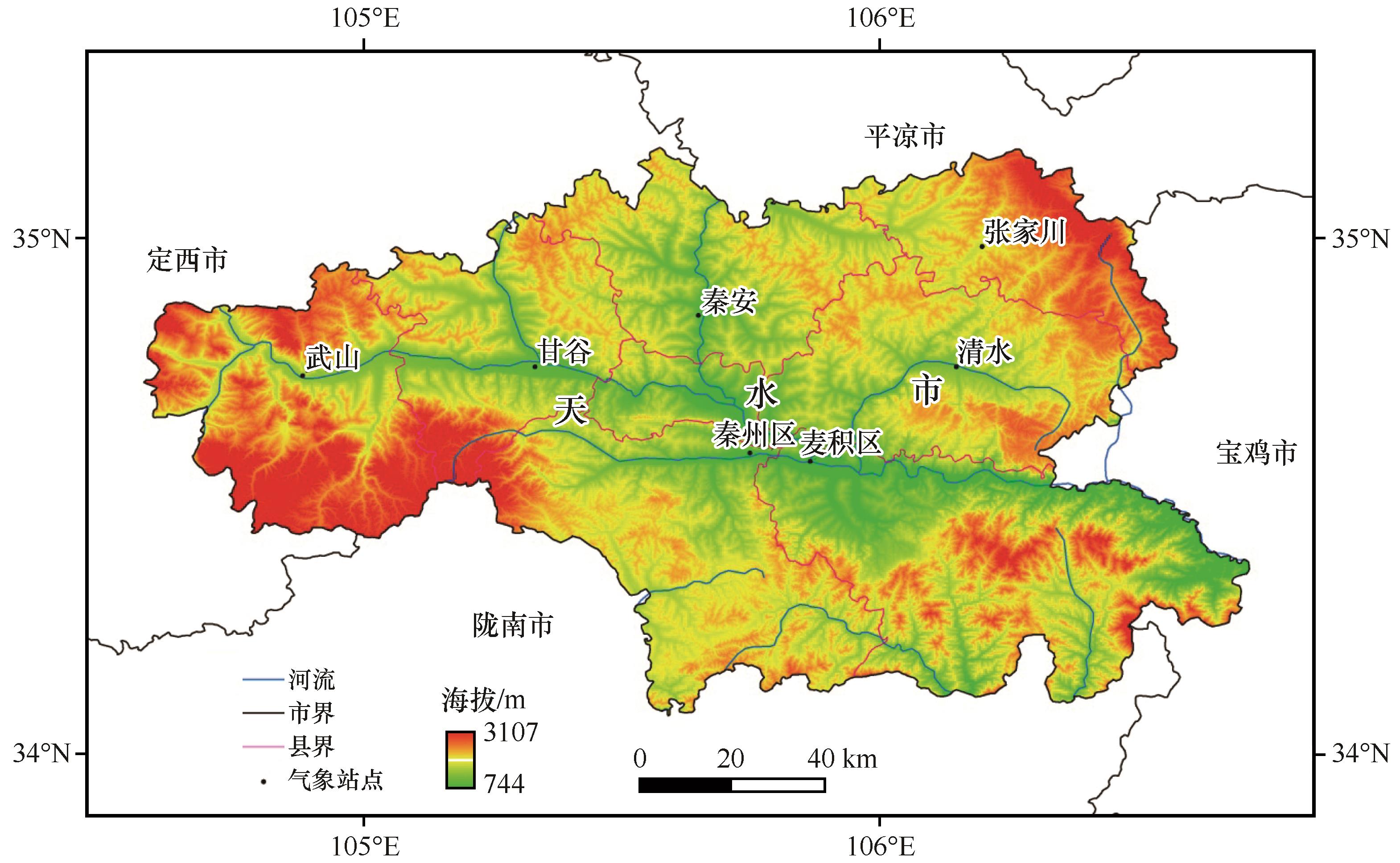
| 6 |
Shao H Y, Liu M, Shao Q F,et al.Research on eco-environmental vulnerability evaluation of the Anning River Basin in the upper reaches of the Yangtze River[J].Environmental Earth Sciences,2014,72(5):1555-1568.
|
| 7 |
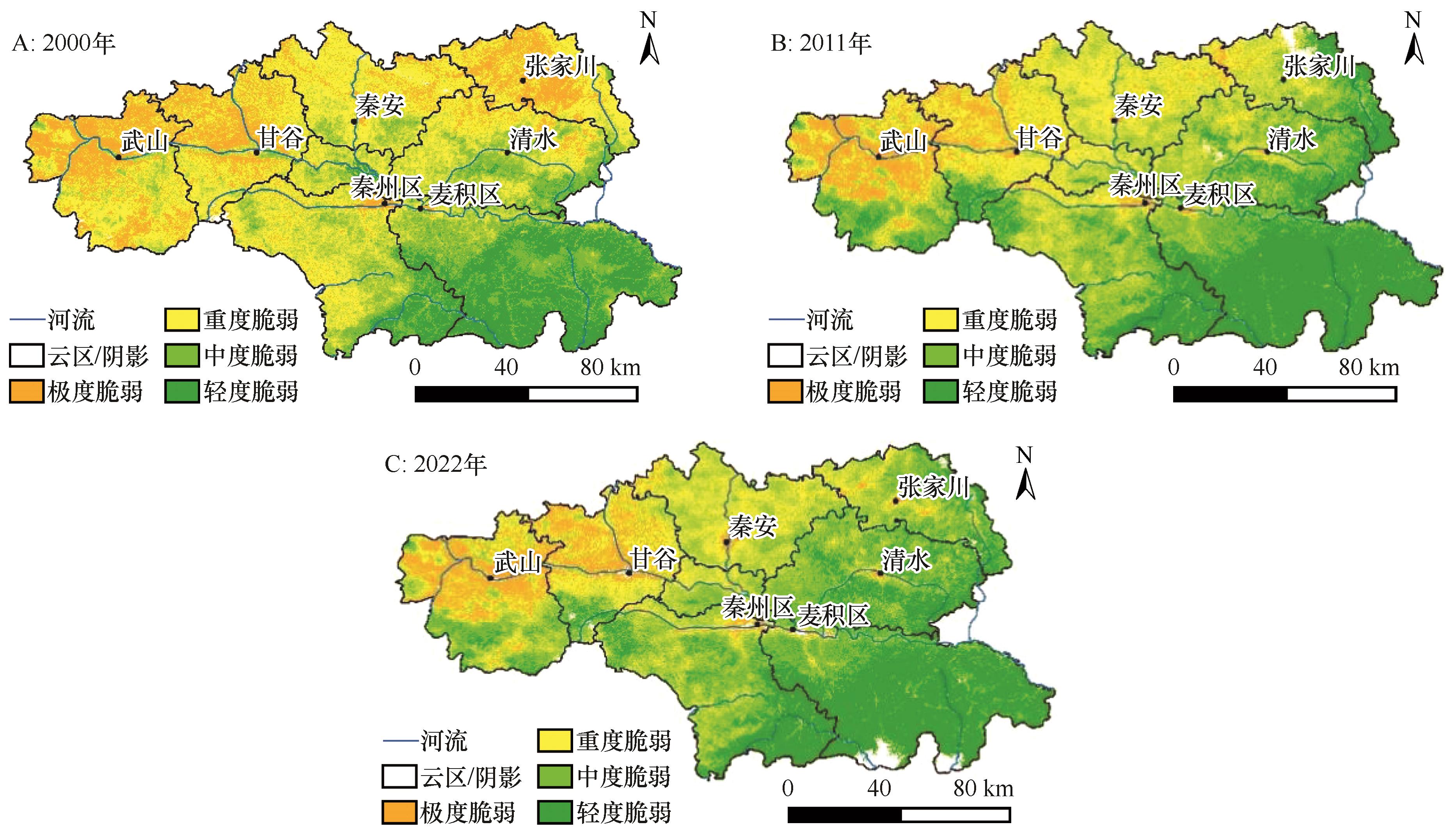
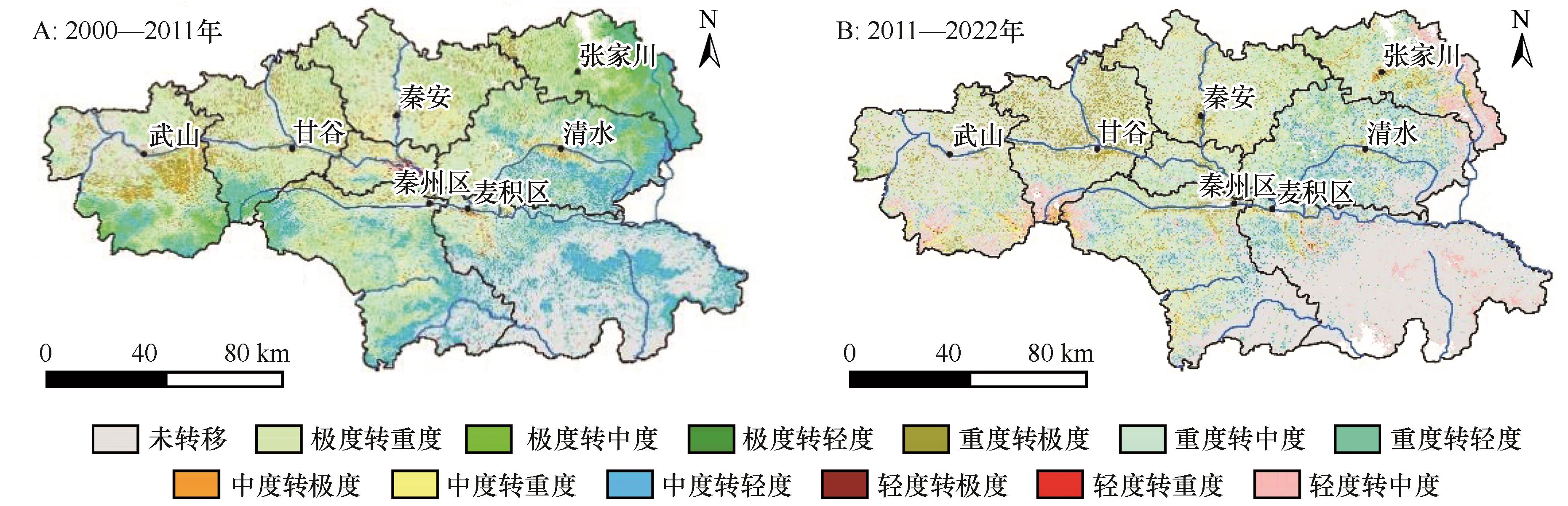
南颖,刘志锋,董叶辉,等. 2000~2008年长白山地区植被覆盖变化对气候的响应研究[J].地理科学,2010(6):921-928.
|
| 8 |
朱士华,方霞,杭鑫,等.中亚草地植被指数(NDVI)对气候变化及人类活动的响应[J].中国沙漠,2022,42(4):229-241.
|
| 9 |
Salvati L, Tombolini I, Perini L,et al.Landscape changes and environmental quality:the evolution of land vulnerability and potential resilience to degradation in Italy[J].Regional Environmental Change,2013,13(6):1223-1233.
|
| 10 |
Mahapatra M, Ramakrishnan R, Rajawat A S.Coastal vulnerability assessment using analytical hierarchical process for South Gujarat coast, India[J].Natural Hazards,2015,76(1):139-159.
|
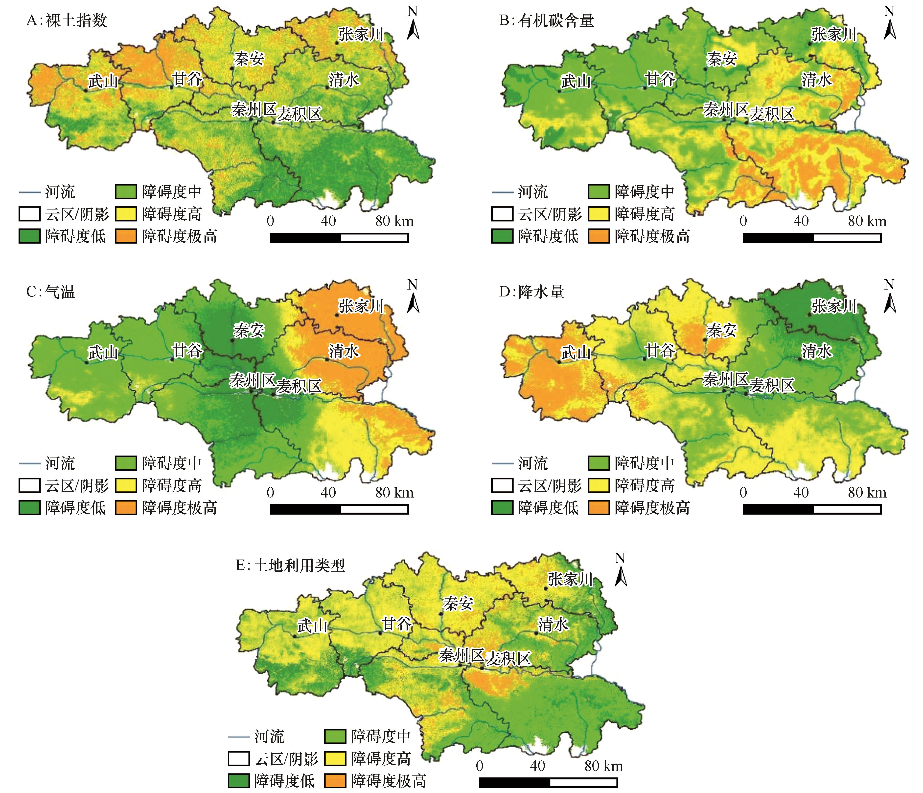
| 11 |
郑慧玲,王永红,马卫.基于PSR模型的珠江三角洲生态环境脆弱性评价[J].水土保持通报,2022(4):210-217.
|
| 12 |
韦晶,郭亚敏,孙林,等.三江源地区生态环境脆弱性评价[J].生态学杂志,2015,34(7):192-199.
|
| 13 |
王玺圳,粟晓玲,张更喜.综合干旱指数的构建及其在泾惠渠灌区的应用[J].干旱地区农业研究,201(4):223-230.
|
| 14 |
李振永,杨彩玲,买自珍,等.基于CRITIC赋权法、模糊概率法评价萝卜品种在宁南山区栽培适应性[J].中国瓜菜,2023(9):102-107.
|
| 15 |
安乐平,蔡玖锱,白娜.天水渭河流域生态环境问题及高质量发展对策[J].中国水土保持,2022(8):10-13.
|
| 16 |
罗逸臻,黄远程,王涛.关中平原城市群生态环境质量时空变化特征及其驱动力[J].地球科学与环境学报,2023,45(6):1316-1329.
|
| 17 |
杨朔,郑晓筝,赵国平.关中平原城市群“三生”空间生态环境效应及影响因素研究[J].干旱区资源与环境,2023(9):26-35.
|
| 18 |
张耀文,张勃,姚荣鹏,等.2000-2020年渭河流域植被覆盖度及产水量时空变化[J].中国沙漠,2022,42(2):223-233.
|
| 19 |
张学玲,余文波,蔡海生,等.区域生态环境脆弱性评价方法研究综述[J].生态学报,2018,38(16):5970-5981.
|
| 20 |
祝聪,彭文甫,张丽芳,等.2006-2016年岷江上游植被覆盖度时空变化及驱动力[J].生态学报,2019(5):1583-1594.
|
| 21 |
易小雅,张德全,刘勇,等.2000-2020年内蒙古杭锦旗植被变化特征及其对气候要素的响应[J].中国沙漠,2024,44(3):51-62.
|
| 22 |
中国气象局. 陆地植被气象与生态质量监测评价等级: [S].
|
| 23 |
郑诚蔚,邓晓红,李宗省,等.甘肃省河西地区水源涵养功能与人类活动强度演变[J].中国沙漠,2024,44(1):189-200.
|
| 24 |
张小瑜,周自翔,唐志雄,等.无定河流域生境质量时空变化及预测[J].中国沙漠,2024,44(3):75-84.
|
| 25 |
徐涵秋.福建省长汀县河田盆地区近35年来地表裸土变化的遥感时空分析[J].生态学报,2013(10):2946-2953.
|
| 26 |
崔亚婷,李嬛,郑龙啸,等.基于RSEI的黄河上游流域生态环境质量变化分析[J].中国沙漠,2023,43(3):107-118.
|
| 27 |
FAO,IIASA,ISRIC,et al.Harmonized World Soil Database (version 1.1)[DB].Rome,Italy:FAO,200.
|
| 28 |
彭立,邓伟,黄佩,等.四川盆地多重生态系统服务景观指数评价与服务簇识别[J].生态学报,2021(23):9328-9340.
|
| 29 |
郭瑞,刘蔚,李宗省,等.祁连山甘肃片区土地利用变化特征及驱动力[J].中国沙漠,2023,43(3):188-198.
|
| 30 |
祁菁.基于组合赋权TOPSIS模型的建设项目水土保持绩效评价及障碍因子诊断[J].水土保持研究,2023(6):458-467.
|
| 31 |
王婷婷,汪妮,金涛.基于障碍因子识别的水资源承载力评价预警[J].人民黄河,2023(8):84-89.
|
| 32 |
陶希东.建设韧性城市:应对极端气候的重要策略[J].人民论坛,2023(15):62-65.
|
| 33 |
申元村.中国脆弱环境区划的初步研究[M]//赵桂久,刘燕华,赵名茶.生态环境综合整治与恢复技术研究:退化生态系统综合整治、恢复与重建示范工程技术研究:第二集.北京:北京科学技术出版社,1995:69-76.
|
| 34 |
徐庆勇,黄玫,李雷,等.晋北地区生态环境脆弱性的GIS综合评价[J].地球信息科学学报,2013,15(5):705-711.
|
| 35 |
董建红,张志斌,笪晓军,等. “三生”空间视角下土地利用转型的生态环境效应及驱动力:以甘肃省为例[J].生态学报, 2021(15):5919-5928.
|
| 36 |
冯志军.甘肃高温干旱叠加并进一步发展[EB/OL].(2022-8-10). .
|
| 37 |
景晓汀.天水市高效节水灌溉发展问题分析及对策探讨[J].甘肃科技纵横,2014(9):25-26.
|
| 38 |
王飞,王宗敏,杨海波,等.基于SPEI的黄河流域干旱时空格局研究[J].中国科学:地球科学,2018,48:1169-1183.
|
| 39 |
杨磊,张涵丹,陈利顶.黄土宽梁缓坡丘陵区次降雨对土壤水分补给效率与阈值研究[J].中国科学:地球科学,2018,48:457-466.
|
 ), 敖泽建3(
 甘公网安备 62010202000688号