中国沙漠 ›› 2023, Vol. 43 ›› Issue (2): 43-52.DOI: 10.7522/j.issn.1000-694X.2022.00113
郝爱华1( ), 薛娴2(), 尤全刚2, 勾朝阳1
收稿日期:2022-04-20
修回日期:2022-08-01
出版日期:2023-03-20
发布日期:2023-04-12
通讯作者:
薛娴
作者简介:薛娴(E-mail: xianxue@lzb.ac.cn)基金资助:
Aihua Hao1(), Xian Xue2(), Quangang You2, Chaoyang Gou1
Received:2022-04-20
Revised:2022-08-01
Online:2023-03-20
Published:2023-04-12
Contact:
Xian Xue
摘要:
作为全球海拔最高的独特自然地理单元,青藏高原对局部、区域乃至全球天气和气候系统具有显著影响。基于气象台站观测资料,对1960年以来青藏高原整体和区域尺度的降水量和极端降水量变化特征及其影响因素研究进行了回顾。结果表明:近60年青藏高原年降水量呈现上升趋势,变化速率为3.8~12.0 mm/10a,但其显著性存在争议。冬春两季降水量显著增加,春季降水量上升速率最大,夏秋两季降水量变化趋势不明显。区域尺度上,三江源区年降水量总体呈现上升趋势,变化速率为7.3~20 mm/10a;雅鲁藏布江流域年降水量呈现不明显上升趋势,变化速率为0.4~9.0 mm/10a;祁连山区年降水量显著增加,变化速率1.0~13.2 mm/10a;年降水量增长速率在青海高原为1.9~3.3 mm/10a,西藏高原为12.5 mm/10a,柴达木盆地为6.7~8.6 mm/10a,共和盆地为7.2 mm/10a。青藏高原极端降水量和极端降水日数明显增多,但是极端降水量变化空间异质性特征显著。青藏高原降水变化的影响因素很多,主要包括大尺度大气环流、高原地表状况及气候变暖。未来应采用更多类型数据源监测青藏高原降水变化,尤其是区域或流域尺度,进一步完善青藏高原降水变化机制研究。
中图分类号:
郝爱华, 薛娴, 尤全刚, 勾朝阳. 青藏高原近60年降水变化研究进展[J]. 中国沙漠, 2023, 43(2): 43-52.
Aihua Hao, Xian Xue, Quangang You, Chaoyang Gou. Review on precipitation change over the Qinghai-Tibetan Plateau in recent 60 years[J]. Journal of Desert Research, 2023, 43(2): 43-52.

图1 青藏高原气象台站及研究区域空间分布
Fig.1 Spatial distribution of meteorological stations and study areas over the Qinghai-Tibetan Plateau
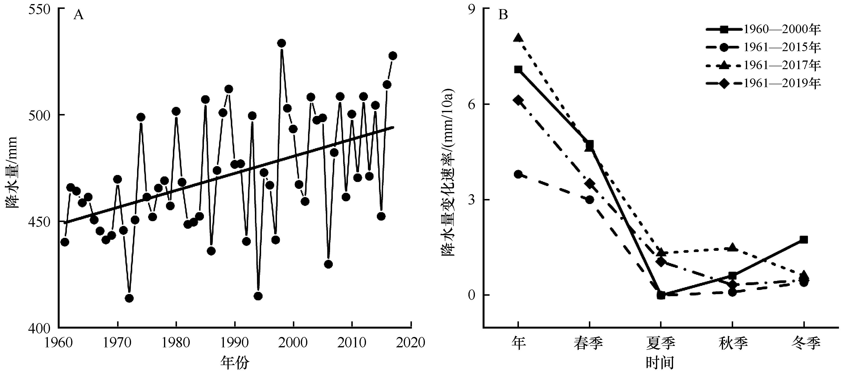
图2 1960年以来青藏高原年降水量变化趋势和年及季节降水量变化速率对比A图数据来源于马伟东等[13];B图中1960—2000年数据来源于黄一民等[21],1961—2015年数据来源于Wan等[14],1961—2017年数据来源于马伟东等[13],1961—2019年数据来源于冯川玉等[17]
Fig.2 Variation trend in average annual precipitation comparison on change rate of annual and season precipitation over the Qinghai-Tibetan Plateau since 1960
| 研究时段 | 气象站点数 | 年降水量变化速率/(mm/10a) | 文献来源 |
|---|---|---|---|
| 1960—2000 | 87 | 7.1 | 黄一民等[ |
| 1960—2000 | 56 | 11.2 | 张磊等[ |
| 1971—2000 | 77 | 12.0 | Wu等[ |
| 1970—2005 | 75 | 11.9 | Liu等[ |
| 1961—2007 | 66 | 9.1 | Li等[ |
| 1970—2009 | 75 | 4.0 | Xie等[ |
| 1961—2010 | 69 | 6.7 | 李晓英等[ |
| 1971—2011 | 83 | 7.5 | Gao等[ |
| 1961—2015 | 65 | 3.8 | Wan等[ |
| 1961—2015 | 72 | 6.6 | 冀钦等[ |
| 1961—2017 | 78 | 8.1 | 马伟东等[ |
| 1971—2017 | 113 | 6.7 | Hu等[ |
| 1961—2019 | 94 | 6.1 | 冯川玉等[ |
表1 1960年以来青藏高原年降水量变化速率
Table 1 Changing rate of average annual precipitation over the Qinghai-Tibetan Plateau since 1960
| 研究时段 | 气象站点数 | 年降水量变化速率/(mm/10a) | 文献来源 |
|---|---|---|---|
| 1960—2000 | 87 | 7.1 | 黄一民等[ |
| 1960—2000 | 56 | 11.2 | 张磊等[ |
| 1971—2000 | 77 | 12.0 | Wu等[ |
| 1970—2005 | 75 | 11.9 | Liu等[ |
| 1961—2007 | 66 | 9.1 | Li等[ |
| 1970—2009 | 75 | 4.0 | Xie等[ |
| 1961—2010 | 69 | 6.7 | 李晓英等[ |
| 1971—2011 | 83 | 7.5 | Gao等[ |
| 1961—2015 | 65 | 3.8 | Wan等[ |
| 1961—2015 | 72 | 6.6 | 冀钦等[ |
| 1961—2017 | 78 | 8.1 | 马伟东等[ |
| 1971—2017 | 113 | 6.7 | Hu等[ |
| 1961—2019 | 94 | 6.1 | 冯川玉等[ |
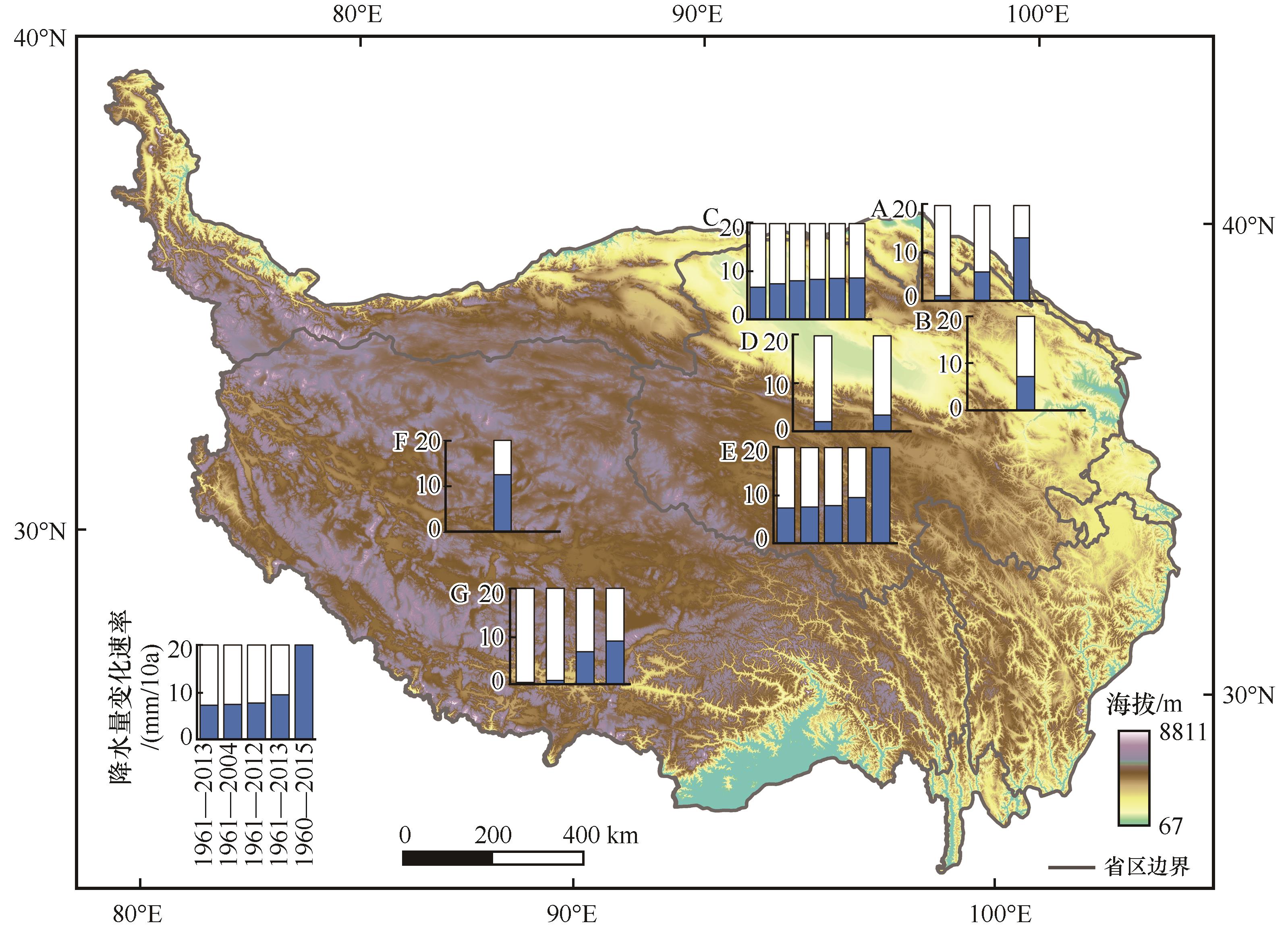
图3 1960年以来青藏高原区域尺度年均降水量变化速率空间分布图中蓝色柱子表示降水量变化速率,横坐标为表2所列各区域内不同研究时段,降水变化速率从左向右逐渐增大;内插小图A:祁连山区;B:共和盆地;C:柴达木盆地;D:青海高原;E:三江源区;F:西藏高原;G:雅鲁藏布江流域
Fig.3 Spatial distribution of average annual precipitation rate at regional scale over the Qinghai-Tibetan Plateau since 1960
| 研究区域 | 研究时段 | 气象站点数 | 年降水量变化速率/(mm/10a) | 文献来源 |
|---|---|---|---|---|
| 三江源区 | 1961—2004 | 18 | 7.5 | 侯文菊等[ |
| 1961—2012 | 18 | 7.8 | 杨佳星等[ | |
| 1961—2013 | 14 | 7.3 | 魏永亮等[ | |
| 1961—2013 | 18 | 9.5 | 强安丰等[ | |
| 1960—2015 | 18 | 20 | 刘晓琼等[ | |
| 雅鲁藏布江流域 | 1961—2005 | 10 | 6.8 | You等[ |
| 1973—2007 | 4 | 0.4 | 李海东等[ | |
| 1978—2009 | 39 | 0.8 | 聂宁等[ | |
| 1980—2013 | 10 | 9.0 | 尼玛旦增[ | |
| 祁连山区 | 1960—2005 | 19 | 6.0 | 张耀宗等[ |
| 1960—2017 | 6 | 13.2 | 程鹏等[ | |
| 1961—2019 | 12 | 1.0 | 肖莲桂等[ | |
| 青海高原 | 1961—2002 | 26 | 1.9 | 汪青春等[ |
| 1961—2004 | 26 | 3.3 | 汪青春等[ | |
| 西藏高原 | 1961—2010 | 38 | 12.5 | 杨春艳等[ |
| 柴达木盆地 | 1961—2006 | 6 | 6.7 | 陈晓光等[ |
| 1971—2010 | 8 | 8.5 | 张娟等[ | |
| 1961—2010 | 8 | 7.4 | Wang等[ | |
| 1961—2010 | 10 | 8.3 | 戴升等[ | |
| 1961—2012 | 6 | 8.6 | 柴军[ | |
| 1981—2017 | 10 | 8.0 | 吕春艳等[ | |
| 共和盆地 | 1960—2012 | 2 | 7.2 | 杨发源等[ |
表2 1960年以来青藏高原区域尺度年降水量变化速率
Table 2 Changing rate of average annual precipitation at regional scale over the Qinghai-Tibetan Plateau since 1960
| 研究区域 | 研究时段 | 气象站点数 | 年降水量变化速率/(mm/10a) | 文献来源 |
|---|---|---|---|---|
| 三江源区 | 1961—2004 | 18 | 7.5 | 侯文菊等[ |
| 1961—2012 | 18 | 7.8 | 杨佳星等[ | |
| 1961—2013 | 14 | 7.3 | 魏永亮等[ | |
| 1961—2013 | 18 | 9.5 | 强安丰等[ | |
| 1960—2015 | 18 | 20 | 刘晓琼等[ | |
| 雅鲁藏布江流域 | 1961—2005 | 10 | 6.8 | You等[ |
| 1973—2007 | 4 | 0.4 | 李海东等[ | |
| 1978—2009 | 39 | 0.8 | 聂宁等[ | |
| 1980—2013 | 10 | 9.0 | 尼玛旦增[ | |
| 祁连山区 | 1960—2005 | 19 | 6.0 | 张耀宗等[ |
| 1960—2017 | 6 | 13.2 | 程鹏等[ | |
| 1961—2019 | 12 | 1.0 | 肖莲桂等[ | |
| 青海高原 | 1961—2002 | 26 | 1.9 | 汪青春等[ |
| 1961—2004 | 26 | 3.3 | 汪青春等[ | |
| 西藏高原 | 1961—2010 | 38 | 12.5 | 杨春艳等[ |
| 柴达木盆地 | 1961—2006 | 6 | 6.7 | 陈晓光等[ |
| 1971—2010 | 8 | 8.5 | 张娟等[ | |
| 1961—2010 | 8 | 7.4 | Wang等[ | |
| 1961—2010 | 10 | 8.3 | 戴升等[ | |
| 1961—2012 | 6 | 8.6 | 柴军[ | |
| 1981—2017 | 10 | 8.0 | 吕春艳等[ | |
| 共和盆地 | 1960—2012 | 2 | 7.2 | 杨发源等[ |
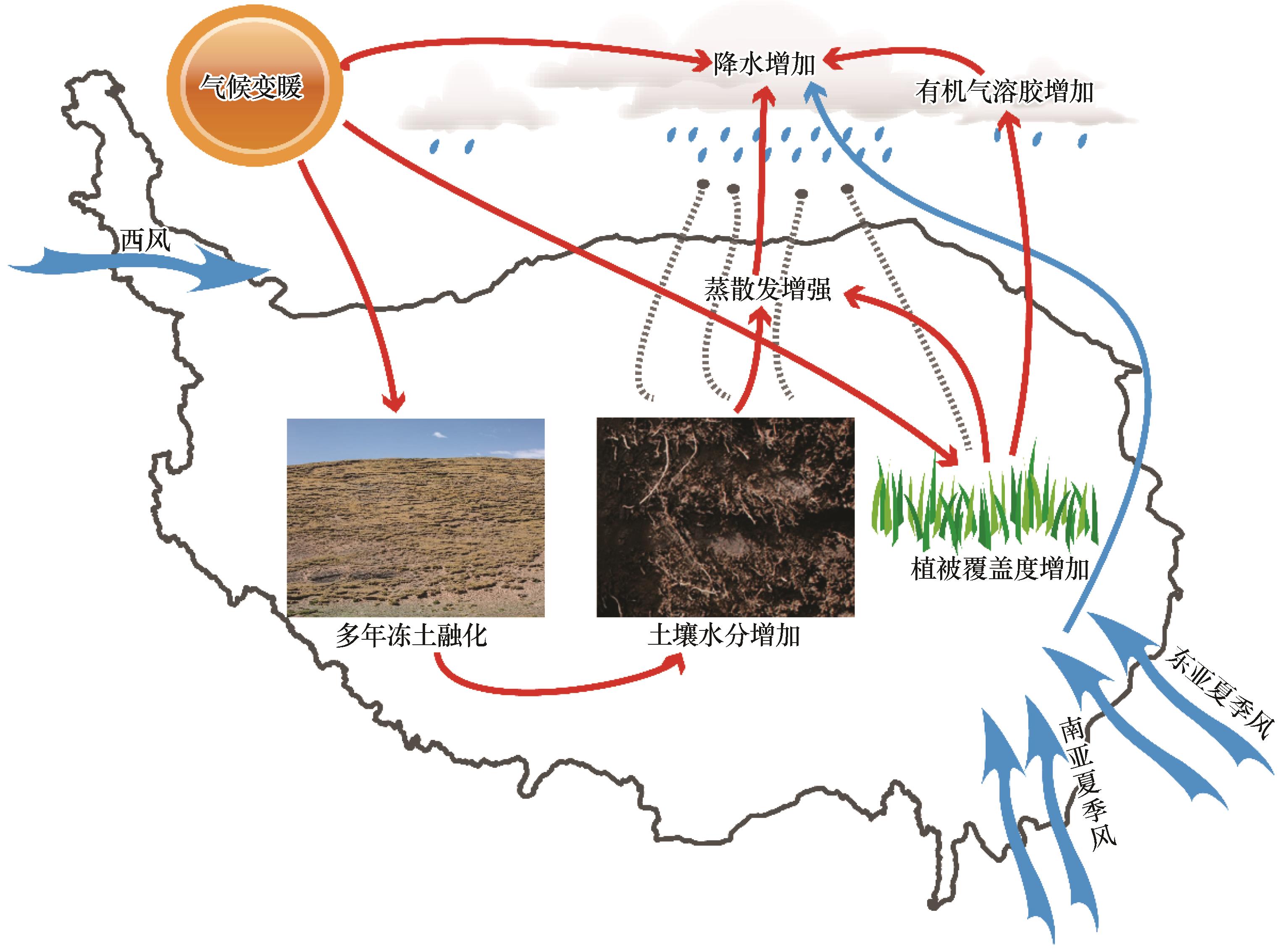
图4 青藏高原降水变化驱动机制
Fig.4 Driving mechanism of precipitation variation over the Qinghai-Tibetan Plateau
| 1 | Li G D Z, Chen H M, Xu M Y,et al.Impacts of topographic complexity on modeling moisture transport and precipitation over the Tibetan Plateau in summer[J].Advances in Atmospheric Sciences,2022,39(7):1151-1166. |
| 2 | Yan Y P, You Q L, Wu F Y,et al.Surface mean temperature from the observational stations and multiple reanalyses over the Tibetan Plateau[J].Climate Dynamics,2020,55(9):2405-2419. |
| 3 | 游庆龙,康世昌,李剑东,等.青藏高原气候变化若干前沿科学问题[J].冰川冻土,2021,43(3):885-901. |
| 4 | Yang K, Wu H, Qin J,et al.Recent climate changes over the Tibetan Plateau and their impacts on energy and water cycle:a review[J].Global and Planetary Change,2014,112:79-91. |
| 5 | Sun C, Xu X D, Wang P J,et al.The warming and wetting ecological environment changes over the Qinghai-Tibetan Plateau and the driving effect of the Asian summer monsoon[J].Journal of Tropical Meteorology,2022,28(1):95-108. |
| 6 | Yao T D.Tackling on environmental changes in Tibetan Plateau with focus on water,ecosystem and adaptation[J].Science Bulletin,2019,64(7):417. |
| 7 | Hu D, Duan A M, Zhang P.Association between regional summer monsoon onset in South Asia and Tibetan Plateau thermal forcing[J].Climate Dynamics,2022,59(3):1115-1132. |
| 8 | 李春晖,何超,万齐林.青藏高原热力作用对南海及周边区域夏季气候的影响研究进展[J].热带气象学报,2019,35(2):268-280. |
| 9 | 段安民,肖志祥,王子谦.青藏高原冬春积雪和地表热源影响亚洲夏季风的研究进展[J].大气科学,2018,42(4):755-766. |
| 10 | Yin Y H, Wu S H, Zhao D S,et al.Modeled effects of climate change on actual evapotranspiration in different eco-geographical regions in the Tibetan Plateau[J].Journal of Geographical Sciences,2013,23(2):195-207. |
| 11 | Wang X J, Pang G J, Yang M X.Precipitation over the Tibetan Plateau during recent decades:a review based on observations and simulations [J].International Journal of Climatology,2018,38(3):1116-1131. |
| 12 | Hu W F, Yao J Q, He Q,et al.Elevation-dependent trends in precipitation observed over and around the Tibetan Plateau from 1971 to 2017[J].Water,2021,13(20):2848. |
| 13 | 马伟东,刘峰贵,周强,等.1961-2017年青藏高原极端降水特征分析[J].自然资源学报,2020,35(12):3039-3050. |
| 14 | Wan G N, Yang M X, Liu Z C,et al.The precipitation variations in the Qinghai-Xizang (Tibetan) Plateau during 1961-2015[J].Atmosphere,2017,8(5):80. |
| 15 | Gao Y H, Li X, Ruby L L,et al.Aridity changes in the Tibetan Plateau in a warming climate[J].Environmental Research Letters,2014,10(3):34013. |
| 16 | 冀钦,杨建平,陈虹举.1961-2015年青藏高原降水量变化综合分析[J].冰川冻土,2018,40(6):1090-1099. |
| 17 | 冯川玉,李陈彧,周志浩,等.青藏高原降水变化特征及趋势分析[J].水文,2022,42(1):75-79. |
| 18 | Tong K, Su F G, Yang D Q,et al.Tibetan Plateau precipitation as depicted by gauge observations,reanalyses and satellite retrievals[J].International Journal of Climatology,2014,34(2):265-285. |
| 19 | 李晓英,姚正毅,肖建华,等.1961-2010年青藏高原降水时空变化特征分析[J].冰川冻土,2016,38(5):1233-1240. |
| 20 | Li L, Yang S, Wang Z Y,et al.Evidence of warming and wetting climate over the Qinghai-Tibet Plateau[J].Arctic Antarctic & Alpine Research,2010,42(4):449-457. |
| 21 | 黄一民,章新平.青藏高原四季降水变化特征分析[J].长江流域资源与环境,2007,16(4):537. |
| 22 | 张磊,缪启龙.青藏高原近40年来的降水变化特征[J].干旱区地理,2007,30(2):240-246. |
| 23 | Wu S H, Yin Y H, Zheng D,et al.Climatic trends over the Tibetan Plateau during 1971-2000[J].Journal of Geographical Sciences,2007,17(2):141-151. |
| 24 | Liu X M, Zheng H X, Zhang M H,et al.Identification of dominant climate factor for pan evaporation trend in the Tibetan Plateau[J].Journal of Geographical Sciences,2011,21(4):594-608. |
| 25 | Xie H, Zhu X.Reference evapotranspiration trends and their sensitivity to climatic change on the Tibetan Plateau (1970-2009)[J].Hydrological Processes,2013,27(25):3685-3693. |
| 26 | You Q L, Kang S C, Aguilar E,et al.Changes in daily climate extremes in the eastern and central Tibetan Plateau during 1961-2005[J].Journal of Geophysical Research: Atmospheres,2008,113:D07101. |
| 27 | 蔡英,李栋梁,汤懋苍,等.青藏高原近50年来气温的年代际变化[J].高原气象,2003,22(5):464-470. |
| 28 | 汤懋苍,白重瑗,冯松,等.本世纪青藏高原气候的三次突变及与天文因素的相关[J].高原气象,1998,17(3):250-257. |
| 29 | Liu L B, Wang Y, Wang Z,et al.Elevation-dependent decline in vegetation greening rate driven by increasing dryness based on three satellite NDVI datasets on the Tibetan Plateau[J].Ecological Indicators,2019,107:105569. |
| 30 | 孟宪红,陈昊,李照国,等.三江源区气候变化及其环境影响研究综述[J].高原气象,2020,39(6):1133-1143. |
| 31 | 刘晓琼,吴泽洲,刘彦随,等.1960-2015年青海三江源地区降水时空特征[J].地理学报,2019,74(9):1803-1820. |
| 32 | You Q L, Kang S C, Wu Y H,et al.Climate change over the Yarlung Zangbo River Basin during 1961-2005[J].Journal of Geographical Sciences,2007,17(4):409-420. |
| 33 | 杨浩,崔春光,王晓芳,等.气候变暖背景下雅鲁藏布江流域降水变化研究进展[J].暴雨灾害,2019,38(6):565-575. |
| 34 | 张仪辉,刘昌明,梁康,等.雅鲁藏布江流域降水时空变化特征[J].地理学报,2022,77(3):603-618. |
| 35 | 肖莲桂,石明章,喇玉先,等.1961-2019年祁连山地区降水变化特征分析[J].青海科技,2020,27(5):76-80. |
| 36 | 张盛魁.祁连山区气候变化的研究[J].青海农林科技,2006(2):15-18. |
| 37 | 贾文雄,何元庆,李宗省,等.祁连山区气候变化的区域差异特征及突变分析[J].地理学报,2008,63(3):257-269. |
| 38 | 侯文菊,铁顺富,张世珍,等.“三江源”地区冬季积雪及气温降水的变化特征[J].青海科技,2010,17(1):60-66. |
| 39 | 杨佳星,樊雨鑫.52年来三江源区气候变化及其环境效应分析[J].青海环境,2019,29(4):169-175. |
| 40 | 魏永亮,韩方昕,解文璇.三江源地区近53年降水变化特征分析[J].青海农林科技,2015(2):45-48. |
| 41 | 强安丰,魏加华,解宏伟.青海三江源地区气温与降水变化趋势分析[J].水电能源科学,2018,36(2):10-14. |
| 42 | 李海东,沈渭寿,佘光辉,等.雅鲁藏布江源区近35年气候变化特征[J].水土保持研究,2010,17(5):63-67. |
| 43 | 聂宁,张万昌,邓财.雅鲁藏布江流域1978-2009年气候时空变化及未来趋势研究[J].冰川冻土,2012,34(1):64-71. |
| 44 | 尼玛旦增.1980-2013年雅鲁藏布江流域气候要素时空特征[J].高原科学研究,2018(1):38-45. |
| 45 | 张耀宗,张勃,刘艳艳,等.近半个世纪以来祁连山区气温与降水变化的时空特征分析[J].干旱区资源与环境,2009,23(4):127-132. |
| 46 | 程鹏,孔祥伟,罗汉,等.近60 a以来祁连山中部气候变化及其径流响应研究[J].干旱区地理,2020,43(5):1192-1201. |
| 47 | 汪青春,秦宁生,张占峰,等.青海高原近40 a降水变化特征及其对生态环境的影响[J].中国沙漠,2007,27(1):153-158. |
| 48 | 汪青春,秦宁生,唐红玉,等.青海高原近44年来气候变化的事实及其特征[J].干旱区研究,2007,24(2):234-239. |
| 49 | 杨春艳,沈渭寿,林乃峰.西藏高原近50年气温和降水时空变化特征研究[J].干旱区资源与环境,2013,27(12):167-172. |
| 50 | 陈晓光,李林,朱西德,等.青海省气候变化的区域性差异及其成因研究[J].气候变化研究进展,2009,5(5):249-254. |
| 51 | 张娟,肖宏斌,徐维新,等.1971-2010年柴达木盆地可降水量变化特征及其与气象条件分析[J].资源科学,2013,35(11):2289-2297. |
| 52 | Wang X J, Yang M X, Liang X W,et al.The dramatic climate warming in the Qaidam Basin,northeastern Tibetan Plateau,during 1961-2010[J].International Journal of Climatology,2014,34(5):1524-1537. |
| 53 | 戴升,申红艳,李林,等.柴达木盆地气候由暖干向暖湿转型的变化特征分析[J].高原气象,2013,32(1):211-220. |
| 54 | 柴军.柴达木盆地近五十年来气候变化特征分析[J].青海气象,2013(4):13-17. |
| 55 | 吕春艳,李旭,刘明歆,等.柴达木盆地1981-2017年降水及大气环流特征分析[J].沙漠与绿洲气象,2020,14(3):78-87. |
| 56 | 杨发源,戴升,张焕萍.53年来共和盆地气候变化特征及其突变研究[J].青海气象,2013(4):7-13. |
| 57 | 时兴合,李林,汪青春,等.环青海湖地区气候变化及其对湖泊水位的影响[J].气象科技,2005,33(1):58-62. |
| 58 | 赵燕宁,时兴合,秦宁生,等.青海南部地区40多年来气候变化的特征分析[J].中国沙漠,2005,25(4):529-534. |
| 59 | 杜军,马玉才.西藏高原降水变化趋势的气候分析[J].地理学报,2004,59(3):375-382. |
| 60 | 卢鹤立,邵全琴,刘纪远,等.近44年来青藏高原夏季降水的时空分布特征[J].地理学报,2007,62(9):946-958. |
| 61 | 汤懋苍.祁连山区降水的地理分布特征[J].地理学报,1985,40(4):323-332. |
| 62 | 边多,杜军.近40年西藏“一江两河”流域气候变化特征[J].应用气象学报,2006,17(2):169-175. |
| 63 | 徐宗学,巩同梁,赵芳芳.近40年来西藏高原气候变化特征分析[J].亚热带资源与环境学报,2006,1(1):24-32. |
| 64 | 张晓,李净,姚晓军,等.近45年青海省降水时空变化特征及突变分析[J].干旱区资源与环境,2012,26(5):6-12. |
| 65 | IPCC.Climate Change 2021:The Physical Science Basis.Contribution of Working Group I to the Sixth Assessment Report of the Intergovernmental Panel on Climate Change[M].Cambridge,UK:Cambridge University Press,2021. |
| 66 | Ge G B T, Shi Z J, Yang X H,et al.Analysis of precipitation extremes in the Qinghai-Tibetan Plateau,China:spatio-temporal characteristics and topography effects[J].Atmosphere,2017,8(7):127. |
| 67 | Zhang K X, Pan S M, Cao L G,et al.Spatial distribution and temporal trends in precipitation extremes over the Hengduan Mountains region,China,from 1961 to 2012[J].Quaternary International,2014,349:346-356. |
| 68 | 杜军,路红亚,建军.1961-2012年西藏极端降水事件的变化[J].自然资源学报,2014,29(6):990-1002. |
| 69 | 游庆龙,康世昌,闫宇平,等.近45年雅鲁藏布江流域极端气候事件趋势分析[J].地理学报,2009,64(5):592-600. |
| 70 | 赵雪雁,王亚茹,张钦,等.近50 a青藏高原东部夏半年强降水事件的气候特征[J].干旱区地理,2015,38(4):675-683. |
| 71 | 曹瑜,游庆龙,马茜蓉.青藏高原中东部夏季极端降水年代际变化特征[J].气象科学,2019,39(4):437-445. |
| 72 | Wang S J, Zhang M J, Wang B L,et al.Recent changes in daily extremes of temperature and precipitation over the western Tibetan Plateau,1973-2011[J].Quaternary International,2013,313:110-117. |
| 73 | Liu W B, Wang L, Chen D L,et al.Large-scale circulation classification and its links to observed precipitation in the eastern and central Tibetan Plateau[J].Climate Dynamics,2016,46(11):3481-3497. |
| 74 | Cui A N, Lu H Y, Liu X Q,et al.Tibetan Plateau precipitation modulated by the periodically coupled westerlies and Asian monsoon[J].Geophysical Research Letters,2021,48(7):e2020GL091543. |
| 75 | Chen X Y, You Q L.Effect of Indian ocean SST on Tibetan Plateau precipitation in the early rainy season[J].Journal of Climate,2017,30(22):8973-8985. |
| 76 | Cherchi A, Navarra A.Influence of ENSO and of the Indian Ocean Dipole on the Indian summer monsoon variability[J].Climate Dynamics,2013,41(1):81-103. |
| 77 | Wang X J, Yang M X, Pang G J,et al.Influences of two land-surface schemes on RegCM4 precipitation simulations over the Tibetan Plateau[J].Advances in Meteorology,2015,2015:106891. |
| 78 | 余忠水,康世昌,蒋建莹.青藏高原夏季夜雨率空间分布及其变化特征[J].山地学报,2011,29(5):627-632. |
| 79 | Xu X D, Lu C G, Shi X H,et al.World water tower: an atmospheric perspective[J].Geophysical Research Letters,2008,35(20):L20815. |
| 80 | Fang K Y, Makkonen R, Guo Z T,et al.An increase in the biogenic aerosol concentration as a contributing factor to the recent wetting trend in Tibetan Plateau[J].Scientific Reports,2015,5(1):14628. |
| 81 | Lau K M, Kim K M.Observational relationships between aerosol and Asian monsoon rainfall,and circulation[J].Geophysical Research Letters,2006,33(21):21810-21815. |
| 82 | 吴佳,高学杰.一套格点化的中国区域逐日观测资料及与其它资料的对比[J].地球物理学报,2013,56(4):1102-1111. |
| 83 | Yin Z Y, Zhang X Q, Liu X D,et al.An assessment of the biases of satellite rainfall estimates over the Tibetan Plateau and correction methods based on topographic analysis[J].Journal of Hydrometeorology,2008,9(3):301-326. |
| 84 | Gao Y C, Liu M F.Evaluation of high-resolution satellite precipitation products using rain gauge observations over the Tibetan Plateau[J].Hydrology and Earth System Sciences,2013,17(2):837-849. |
| 85 | 吴永红.湖泊沉积物 Mg/Ca 作为气候代用指标的局限性[J].安庆师范学院学报(自然科学版),2016,22(3):102-105. |
| 86 | Pithan F.Asian water towers: more on monsoons[J].Science,2010,330(6004):584-585. |
| 87 | Wang C H, Yang K, Zhang F M.Impacts of soil freeze-thaw process and snow melting over Tibetan Plateau on Asian summer monsoon system:a review and perspective[J].Frontiers in Earth Science,2020,8:133. |
| 88 | You Q L, Wu T, Shen L C,et al.Review of snow cover variation over the Tibetan Plateau and its influence on the broad climate system[J].Earth-Science Reviews,2020,201:103043. |
| [1] | 胡梦珺, 庄静, 孙文丽, 郑登友, 吉天琪, 许澳康. 青藏高原东北部全新世常量元素地球化学特征及环境演变[J]. 中国沙漠, 2023, 43(2): 11-20. |
| [2] | 张宇硕, 沈雪瑞, 眭任静, 鲍捷, 喻忠磊, 赵林, 张学斌. 黄河流域A级旅游景区空间格局及其影响因素的多尺度分析[J]. 中国沙漠, 2022, 42(6): 103-115. |
| [3] | 刘洋, 王娅, 周立华. 基于过程和结果的甘肃古浪黄花滩生态移民工程绩效评价[J]. 中国沙漠, 2022, 42(6): 185-193. |
| [4] | 徐雪, 王永瑜. 甘肃省新型城镇化与乡村振兴协调水平及其影响因素[J]. 中国沙漠, 2022, 42(5): 1-13. |
| [5] | 张雯, 杜丁丁, 李志文, 吴汪洋, 李向洁, 白永会. 鄱阳湖沙地沉积物粒度特征及其影响因素[J]. 中国沙漠, 2022, 42(5): 122-132. |
| [6] | 吴倩倩, 张晓, 徐书兴, 杨晓晖, 刘艳书, 李瀚之, 时忠杰. 亚洲内陆干旱区NDVI与树木生长的气候响应及其影响因素[J]. 中国沙漠, 2022, 42(4): 1-10. |
| [7] | 胡菁菁, 胡光印, 董治宝. 黄河源区玛多盆地沙漠化土地粒度特征[J]. 中国沙漠, 2022, 42(4): 242-252. |
| [8] | 张晓娅, 杜凤莲. 阿拉善左旗沙区居民生态补偿支付意愿及其影响因素[J]. 中国沙漠, 2022, 42(2): 54-61. |
| [9] | 康雷, 杨兆萍, 韩芳. 新疆非物质文化遗产的空间分布及其影响因素[J]. 中国沙漠, 2022, 42(1): 158-166. |
| [10] | 周成, 柳炳华, 张旭红, 田娟, 周霖. 黄河流域文物保护单位空间分布特征及其影响因素[J]. 中国沙漠, 2021, 41(6): 10-20. |
| [11] | 丁志伟, 赵芮, 简子菡, 孟怡伟, 张改素. 城乡融合视角下黄河流域镇域经济的空间格局及其影响因素[J]. 中国沙漠, 2021, 41(6): 195-204. |
| [12] | 曾方明, 薛红盼. 青藏高原东北部晚第四纪黄土-古土壤元素组成数据集[J]. 中国沙漠, 2021, 41(6): 262-264. |
| [13] | 邢丽珠, 张方敏, 邢开成, 李云鹏, 卢琦, 鲁飞飞. 基于RWEQ模型的内蒙古巴彦淖尔市土壤风蚀变化特征及归因分析[J]. 中国沙漠, 2021, 41(5): 111-119. |
| [14] | 朱陇强, 王晓云, 刘佳敏, 颉耀文. 甘肃河西地区历史遗址分布及其自然环境背景[J]. 中国沙漠, 2021, 41(4): 121-128. |
| [15] | 孙高鹏, 刘宪锋, 王小红, 李双双. 2001—2020年黄河流域植被覆盖变化及其影响因素[J]. 中国沙漠, 2021, 41(4): 205-212. |
| 阅读次数 | ||||||
|
全文 |
|
|||||
|
摘要 |
|
|||||
©2018中国沙漠 编辑部
地址: 兰州市天水中路8号 (730000)
电话:0931-8267545
Email:caiedit@lzb.ac.cn;desert@lzb.ac.cn

 甘公网安备 62010202000688号