img

官方微信

高级检索

中国沙漠 ›› 2023, Vol. 43 ›› Issue (2): 288-298.DOI: 10.7522/j.issn.1000-694X.2022.00147

• • 上一篇    

毛乌素沙地流动沙丘土壤水分模拟及渗漏特征

洪光宇1(), 王晓江1(), 苏庆溥2, 海龙1, 王少昆3, 高孝威1, 徐艳艳4, 周景山5, 李卓凡1, 李梓豪1, 胡尔查1   

  1. 1.内蒙古自治区林业科学研究院,内蒙古 呼和浩特 010010
    2.乌审旗委宣传部,内蒙古 乌审旗 017300
    3.中国科学院西北生态环境资源研究院,甘肃 兰州 730000
    4.内蒙古自治区大青山国家级自然保护区管理局,内蒙古 呼和浩特 010010
    5.内蒙古自治区林业和草原局综合保障中心,内蒙古 呼和浩特 010010
  • 收稿日期:2022-10-24 修回日期:2022-12-12 出版日期:2023-03-20 发布日期:2023-04-12
  • 通讯作者: 王晓江
  • 作者简介:王晓江(E-mail: xjwang21cn@163.com
    洪光宇(1985—),女,内蒙古呼和浩特人,博士,副研究员,研究方向为沙地水资源管理与应用。E-mail: nmghgy@163.com
  • 基金资助:
    国家自然科学基金项目(41867043);中央财政林业和草原科技推广示范项目(内林草科推[2022]09号);内蒙古科技重大专项(2019ZD007)

Simulation of soil moisture and leakage characteristics of mobile dunes in Mu Us Sandy Land

Guangyu Hong1(), Xiaojiang Wang1(), Qingpu Su2, Long Hai1, Shaokun Wang3, Xiaowei Gao1, Yanyan Xu4, Jingshan Zhou5, Zhuofan Li1, Zihao Li1, Ercha Hu1   

  1. 1.Inner Mongolia Academy of Forestry Sciences,Hohhot 010010,China
    2.Publicity Department of CPC Wushen Banner Committee,Wushen Banner 017300,Inner Mongolia,China
    3.Northwest Institute of Eco-Environment and Resources,Chinese Academy of Sciences,Lanzhou 730000,China
    4.Daqingshan National Nature Reserve Administration of Inner Mongolia Autonomous Region,Hohhot 010010,China
    5.Comprehensive Security Center of Forestry and Grassland Bureau of Inner Mongolia Autonomous Region,Hohhot 010010,China
  • Received:2022-10-24 Revised:2022-12-12 Online:2023-03-20 Published:2023-04-12
  • Contact: Xiaojiang Wang

摘要:

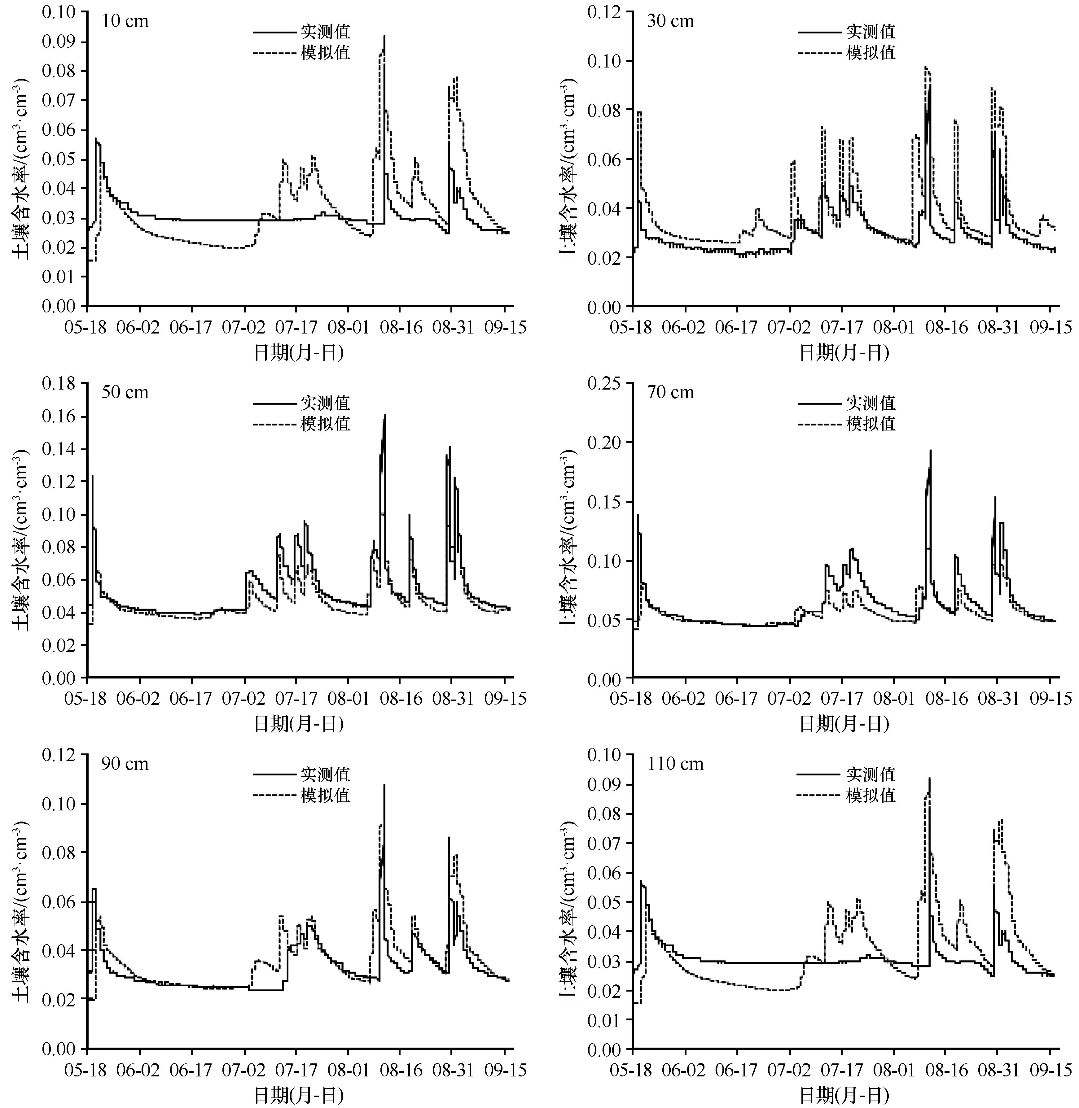
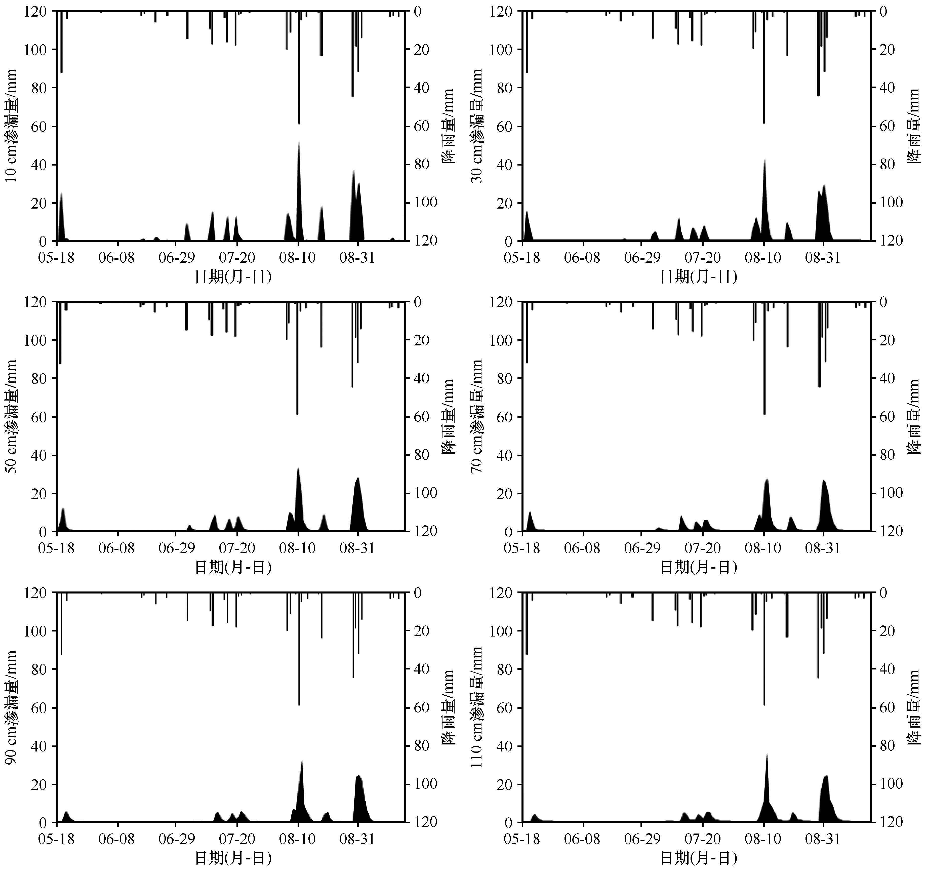
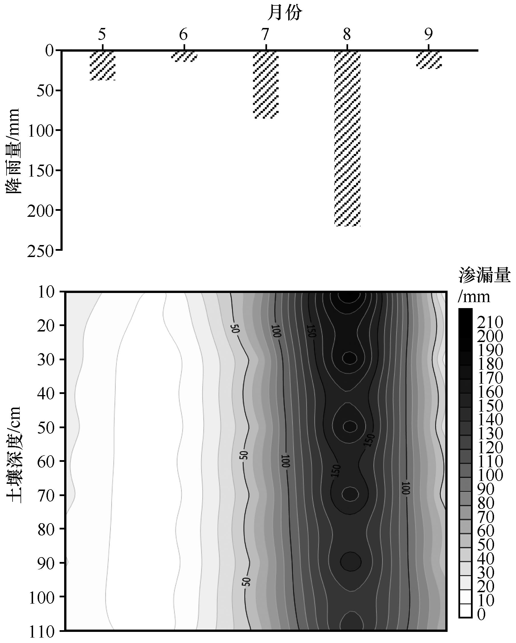
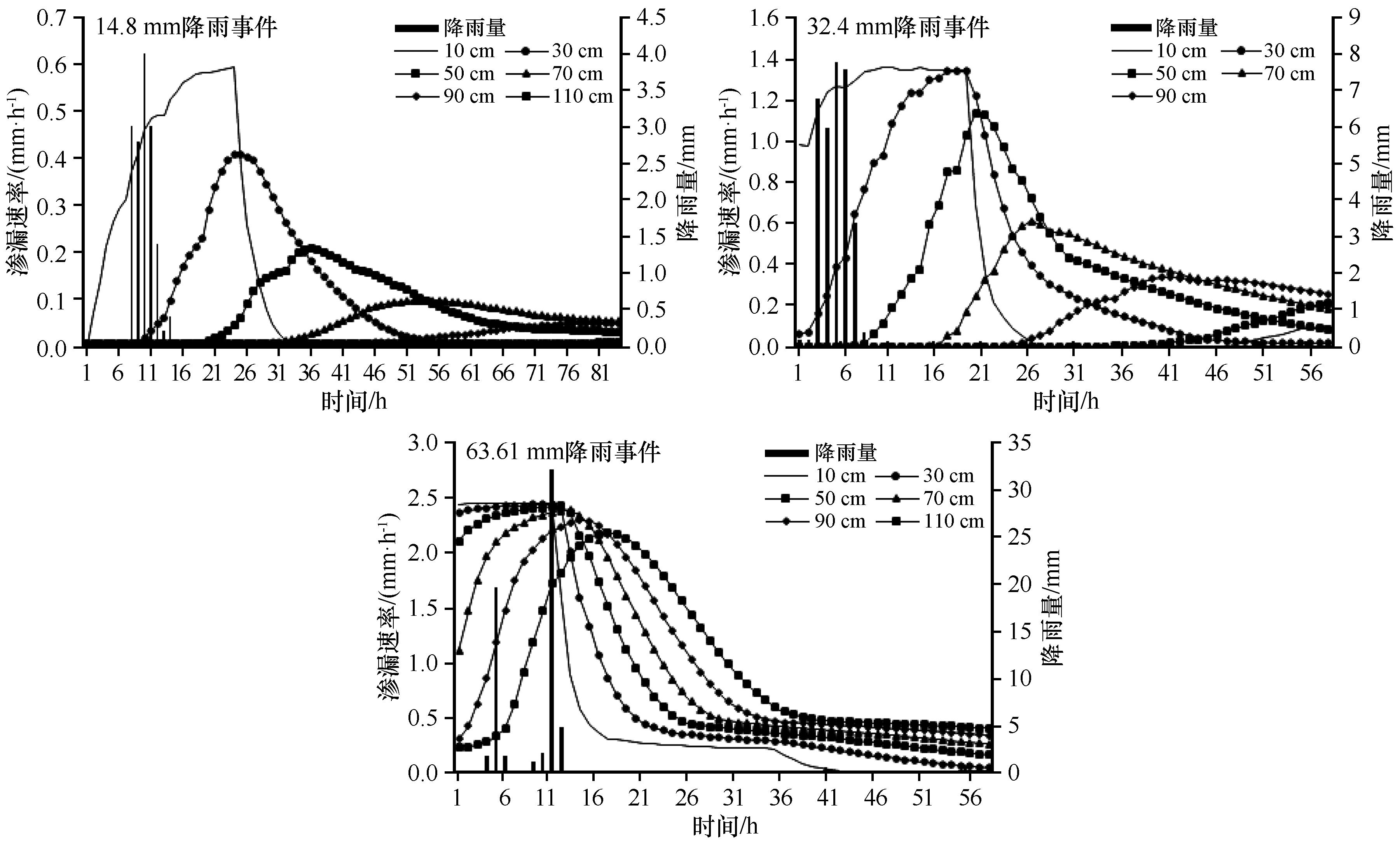
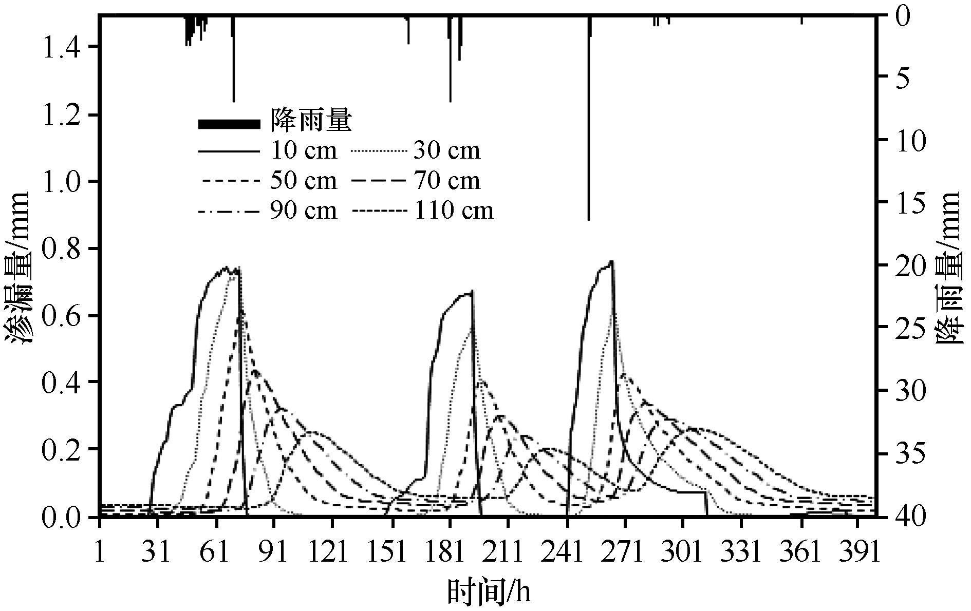
干旱半干旱区土壤水分的主要补给来自于降水,降水决定土壤水分时空格局变化,对不同深度土壤水分的补给起到了关键作用。通过优化参数后的Hydrus-1D模型,分析出毛乌素沙地流动沙丘10、30、50、70、90、110 cm土层水分渗漏量变化特征及其对不同降雨格局的响应。结果表明:5—9月,流动沙丘不同深度土层渗漏量随着深度的增加存在一定差异,5—8月渗漏量随着土层深度的增加呈递减趋势,9月呈增加趋势。渗漏量与降水量变化一致,最大渗漏量发生在8月,110 cm处渗漏量为148.51 mm,占该月降水量的67.5%;最大渗漏速率与最大渗漏量发生在降雨量大的降水事件,降水量和土壤初始含水量共同决定了渗漏速率及渗漏时长。14.8 mm降水可渗漏到110 cm深度土层,达到最大渗漏速率的累计渗漏量为1.89 mm,占降水量的13.69%。连续降水事件有利于水分的深层渗漏补给,并且缩短了各土层渗漏速率到达峰值的时间。

关键词: 毛乌素沙地, 流动沙丘, 降水入渗, 渗漏, Hydrus-1D

Abstract:

The main supply of soil water comes from precipitation, which determines the changes of soil water patterns spatially and temporally in arid and semi-arid areas. Precipitation also plays a key role in the supply of soil water at different soil depths in sandy areas. In this study, the hydro 1D model with optimized parameters was used to analyze the variation characteristics of soil water leakage at different depths of 10, 30, 50, 70, 90 and 110 cm in the mobile dunes of Mu Us Sandy Land and its response to different rainfall patterns. The results showed that the amount of soil water leakage was different at different soil depths in mobile dunes from May to September. The amount of water leakage decreased along the increase of the soil depth from May to August. The amount of water leakage increased along the increase of the soil depth in September. The changes of water leakage was consistent with precipitation. The maximum water leakage occurred in August, that the amount of soil water leakage was 148.51 mm at the depth of 110 cm, accounting for 67.5% of the monthly precipitation. The maximum leakage rate and the maximum leakage amount accompanied with large rainfall events. The amount of rainfall and the initial soil water content jointly determined the soil water leakage rate and duration. The soil water will infiltrate to 110 cm when the rainfall reached to 14.8 mm, and the cumulative leakage reaching the maximum leakage rate is 1.89 mm, accounting for 13.69% of the precipitation. Continuous precipitation events are conducive to recharge the deep water, and they shorten the time when the leakage rate reaches the peak in each soil layer Our results from the estimation of soil water leakage in sandy soils could provide theoretical basis in the assessment of water resources and water demand for ecological construction in arid and semi-arid regions.

Key words: Mu Us Sandy Land, mobile dunes, rainfall infiltration, leakage, Hydrus-1D model

中图分类号: