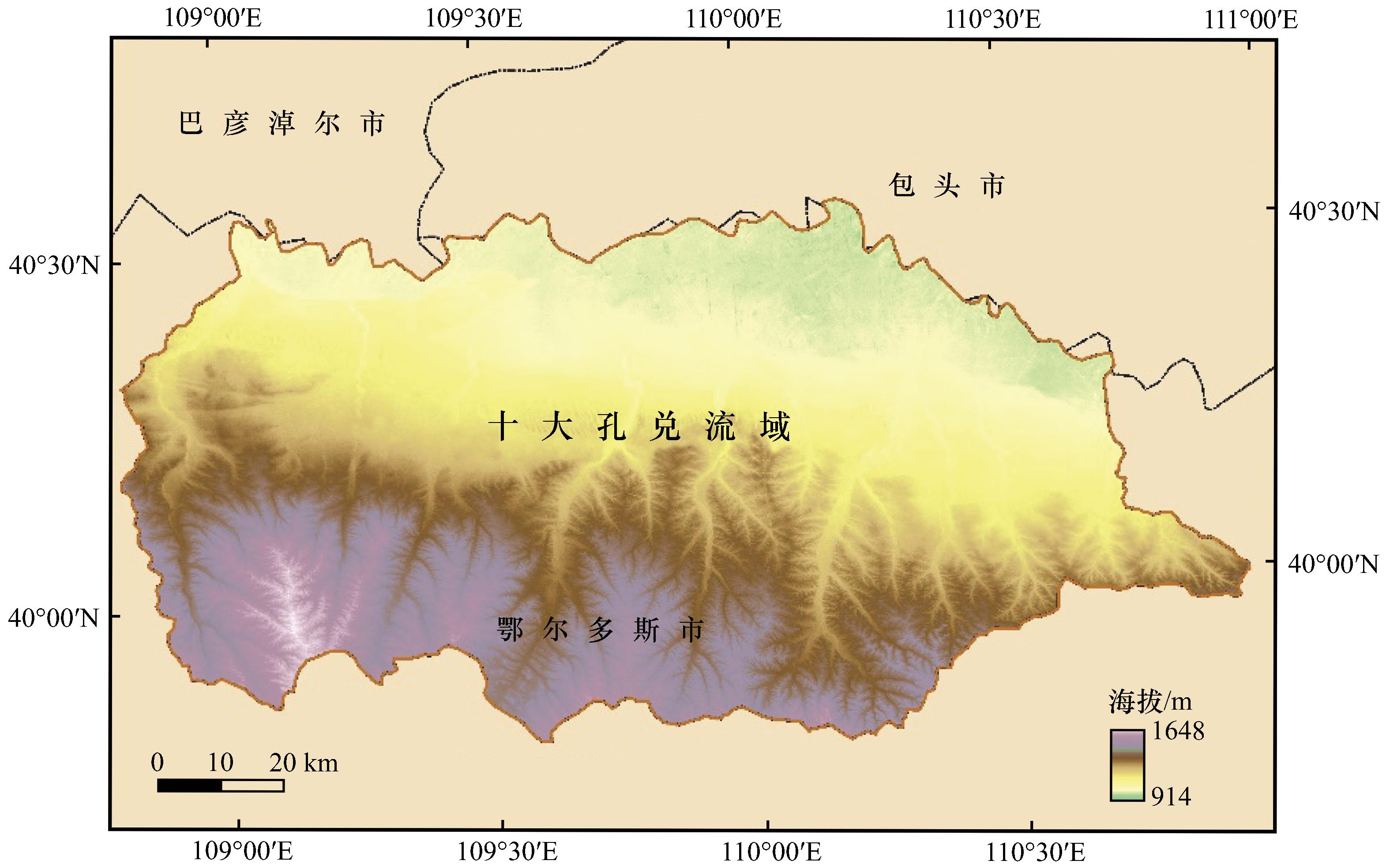
| 1 |
张颖,赵宇鸾.黔桂岩溶山区土地利用程度演变的空间分异特征[J].水土保持研究,2018,25(1):287-297.
|
| 2 |
陈磊,孙佳新,姜海,等.南京市土地利用结构时空格局及驱动因素[J].水土保持研究,2020,27(1):197-206.
|
| 3 |
姜飞强.基于耕地进出平衡的土地利用格局动态变化研究[J].华北自然资源,2023(6):157-160.
|
| 4 |
武帅,田冰,顾世杰,等.植被覆盖度对生态脆弱性动态演变的影响:以河北省张家口为例[J].水土保持研究,31(2):310-320.
|
| 5 |
项颂,庞燕,杨天学,等.内蒙古典型草原区土地利用动态变化及其对水质的影响[J].农业环境科学学报,2022,41(4):857-867.
|
| 6 |
罗谷松,李涛.碳排放影响下的中国省域土地利用效率差异动态变化与影响因素[J].生态学报,2019,39(13):4751-4760.
|
| 7 |
Winkler K, Fuchs R, Rounsevell M,et al.Global land use changes are four times greater than previously estimated[J].Nature Communications,2021,12(1):2501.
|
| 8 |
付乐,迟妍妍,于洋,等.2000-2020年黄河流域土地利用变化特征及影响因素分析[J].生态环境学报,2022,31(10):1927-1938.
|
| 9 |
赵子娟,范蓓蕾,王玉庭,等.2000-2018年西辽河流域植被覆盖度时空变化特征及影响因素研究[J].中国农业资源与区划,2021,42(12):75-88.
|
| 10 |
贾丹阳,熊祯祯,高岩,等.近30 a台特玛湖地区土地利用/土地覆被变化及其影响因素[J].干旱区地理,2021,44(4):1022-1031.
|
| 11 |
Carlos A T G, Vanderlise G, Sr Diana,et al.Land‐use change alters the stocks of carbon, nitrogen,and phosphorus in a Haplic Cambisol in the Brazilian semi‐arid region[J].Soil Use and Management,2022,38(1):953-963.
|
| 12 |
姚海芳,师长兴,顾畛逵.气候变化和人类活动对黄河上游十大孔兑水沙过程的影响[J].干旱区地理,2018,41(3):472-479.
|
| 13 |
裴新富,甘枝茂,刘啸.黄河流域退耕还林有关技术问题研究[J].干旱区资源与环境,2003(3):98-102.
|
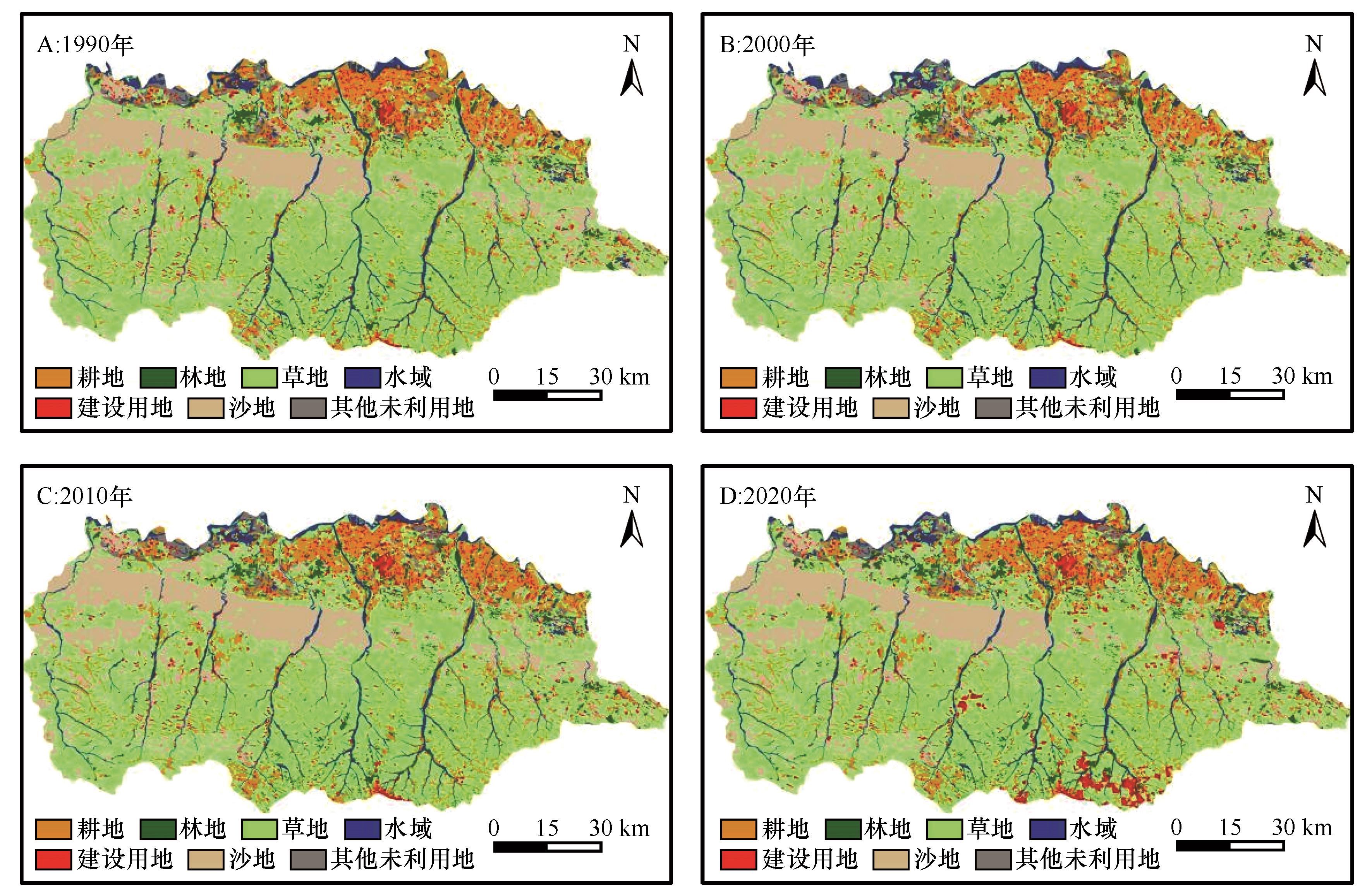
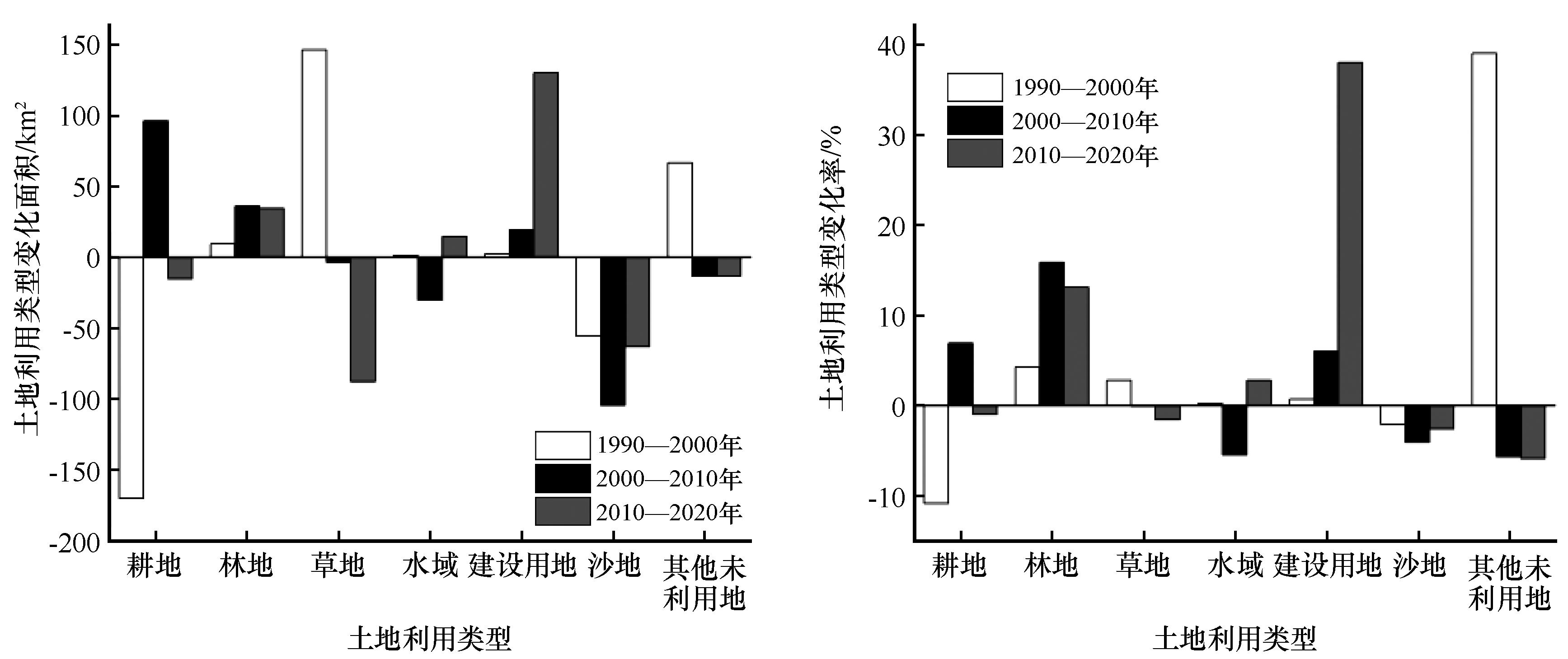
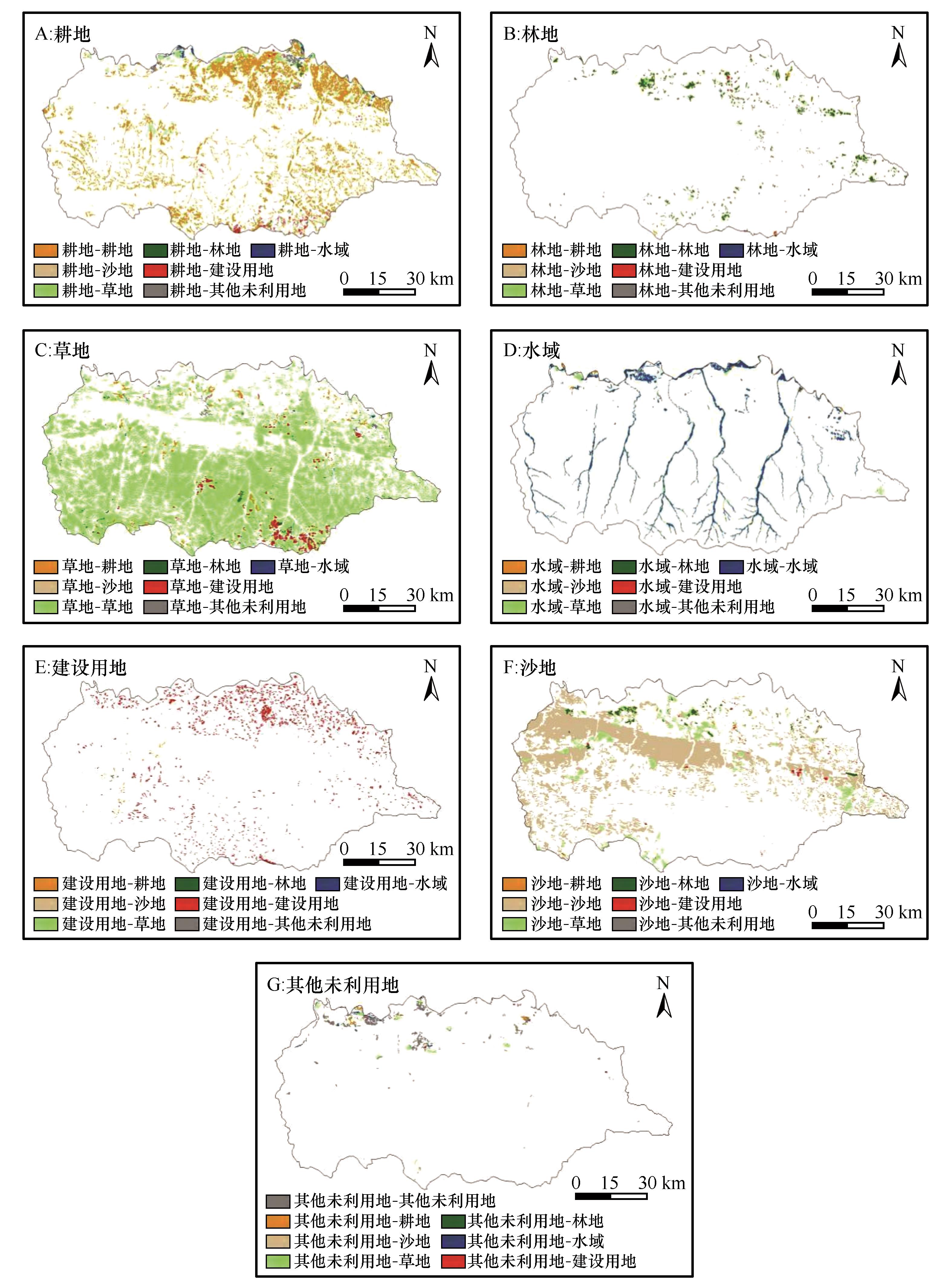
| 14 |
刘晓林,杨胜天,周旭,等.1980年以来黄河内蒙古段十大孔兑流域土地利用变化时空特征[J].南水北调与水利科技,2016,14(1):30-36.
|
| 15 |
刘振婷,包雪源,郭建英,等.十大孔兑流域土地利用变化与生态系统健康耦合分析[J].绿色科技,2023,25(10):8-16.
|
| 16 |
李磊.达拉特旗土地利用动态变化及驱动机制研究[D].呼和浩特:内蒙古农业大学,2013.
|
| 17 |
冯异星.遥感与GIS支持下的土地利用动态变化研究[D].呼和浩特:内蒙古师范大学,2008.
|
| 18 |
康文慧,徐进才,张武文,等.内蒙古达拉特旗土地利用方式对土壤养分的影响[J].干旱区资源与环境,2014,28(8):161-166.
|
| 19 |
陈燕,齐清文.达拉特旗土地利用及水土保持措施现状遥感调查与制图[J].水土保持学报,2003(6):137-139.
|
| 20 |
钟莉娜,郭旭东,赵文武,等.内蒙古鄂尔多斯市达拉特旗土地利用结构变化对生态系统服务价值的影响[J].中国土地科学,2014,28(10):25-32.
|
| 21 |
赵峰,鞠洪波,刘华,等.基于生态工程区的土地利用变化和景观格局分析:以内蒙古达拉特旗为例[J].西北林学院学报,2010,25(1):216-220.
|
| 22 |
姬宝霖,吕忠义,申向东,等.内蒙古达拉特旗十大孔兑综合治理方案研究[J].人民黄河,2004(1):31-32.
|
| 23 |
王慧.黄河内蒙古段十大孔兑生态脆弱性演变及驱动力分析[D].呼和浩特:内蒙古农业大学,2020.
|
| 24 |
娄和震,杨胜天,周秋文,等.延河流域2000-2010年土地利用/覆盖变化及驱动力分析[J].干旱区资源与环境,2014,28(4):15-21.
|
| 25 |
任斐鹏,江源,熊兴,等.东江流域近20年土地利用变化的时空差异特征分析[J].资源科学,2011,33(1):143-152.
|
| 26 |
胡谦磊.基于HOG和随机森林的极限学习机图像分类研究[D].湖南湘潭:湘潭大学,2018.
|
| 27 |
吴梦红.西辽河流域湿地演变特征及其驱动力研究[D].长春:吉林大学,2019.
|
| 28 |
杨祯琦,麻明友,田建林.土地利用景观格局的地形分异及驱动机制研究:以张家界市永定区为例[J].遥感技术与应用,2023,38(5):1226-1238.
|
| 29 |
滕晗,夏建新,任华堂.退耕还林还草工程对黄土高原延河流域水土保持功能影响研究[J].泥沙研究,2015(4):14-19.
|
| 30 |
胡春宏,王延贵,张燕菁,等.中国江河水沙变化趋势与主要影响因素[J].水科学进展,2010,21(4):524-532.
|
| 31 |
畅田颖,张仲伍,乔旭宁,等.黄河流域2000-2020年“三生”空间土地利用转型及其生态环境效应[J].水土保持通报,2021,41(4):268-275.
|
| 32 |
闫丽,包慧娟,郭佳.内蒙古达拉特旗土地沙漠化动态研究[J].内蒙古师范大学学报(自然科学汉文版),2009,38(3):315-319.
|
| 33 |
苗平,达古拉.黄河流域十大孔兑山水林田湖草沙系统治理对策措施[J].内蒙古水利,2023(2):65-66.
|
| 34 |
苗平,陈燕.浅析十大孔兑岸线利用与管控措施与对策[J].内蒙古水利,2022(12):41-43.
|
| 35 |
王丽云,马振刚,高云飞,等.近10 a来十大孔兑现状淤地坝拦沙作用分析[J].人民黄河,2018,40(9):89-92.
|
| 36 |
曾令建.十大孔兑区生态系统服务功能及其权衡协同关系[D].呼和浩特:内蒙古农业大学,2023.
|
| 37 |
李晔琳.鄂尔多斯市城乡规划工作开展对策[J].乡村科技,2020(21):26-29.
|
| 38 |
巴特尔.浅析鄂尔多斯市土地利用总体规划实施中存在的问题[J].内蒙古林业调查设计,2015,38(4):113-114.
|
| 39 |
娄佳乐.1986-2020年黄河流域十大孔兑土地利用与植被覆盖时空演变及影响因素研究[D].呼和浩特:内蒙古农业大学,2023.
|
| 40 |
石冰,王开运,邹春静,等.大气CO2浓度和温度升高对草本植物生长的影响[J].现代农业科技,2008(15):15-16.
|
| 41 |
张荣刚,王金花,靳莉君,等.引发2016年十大孔兑严重山洪的暴雨诊断分析[J].人民黄河,2017,39(9):1-4.
|
| 42 |
Yao H, Shi C, Shao W,et al.Impacts of climate change and human activities on runoff and sediment load of the Xiliugou Basin in the upper Yellow River[J].Advances in Meteorology,2015,481713:1-12.
|
| 43 |
Wei W, Chen L, Fu B,et al.The effect of land uses and rainfall regimes on run⁃off and soil erosion in the semi⁃arid loess hilly area,China[J].Journal of Hydrology,2007,335(3):247-258.
|
| 44 |
王文君,陈新闯,李小倩,等.十大孔兑降雨侵蚀产沙时空分布特征及预测[J].人民黄河,2019,41(4):1-6.
|
 ), 杜军1(
 甘公网安备 62010202000688号