
- CN 62-1070/P
- ISSN 1000-694X
- Bimonthly 1981
Journal of Desert Research ›› 2020, Vol. 40 ›› Issue (6): 139-150.DOI: 10.7522/j.issn.1000-694X.2020.00037
Previous Articles Next Articles
Lei Wu( ), Changbin Li(), Liuming Wang, Xuhong Xie, Yuan Zhang, Jianmei Wei
Received:2019-09-06
Revised:2020-04-28
Online:2020-12-09
Published:2020-12-09
Contact:
Changbin Li
CLC Number:
Lei Wu, Changbin Li, Liuming Wang, Xuhong Xie, Yuan Zhang, Jianmei Wei. Division and application of desert-oasis system in arid Northwest China based on ESA-LUC and MODIS-NDVI[J]. Journal of Desert Research, 2020, 40(6): 139-150.
Add to citation manager EndNote|Ris|BibTeX
URL: http://www.desert.ac.cn/EN/10.7522/j.issn.1000-694X.2020.00037
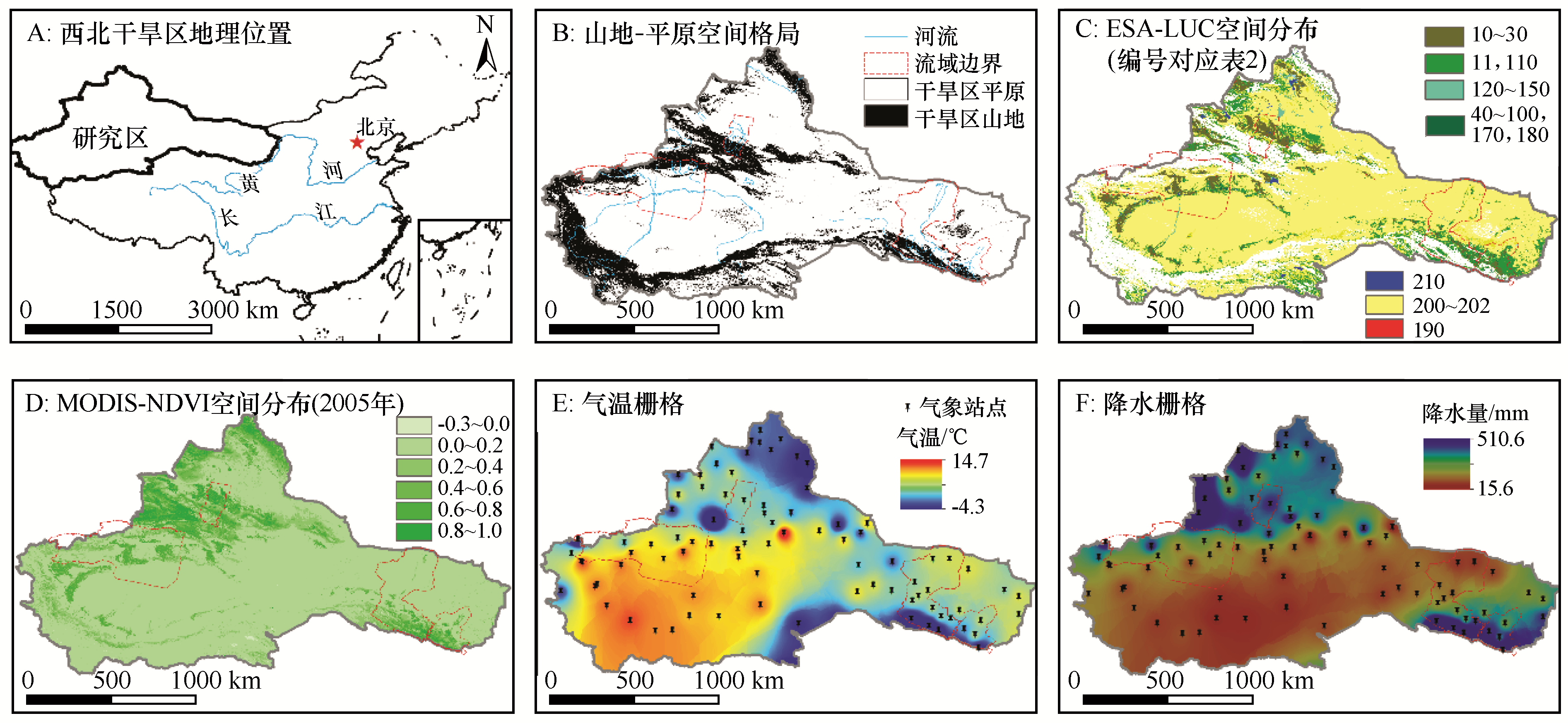
Fig.1 Location map of the arid northwestern China combined with spatial distributions of various factors (A.location map; B. spatial pattern of mountain-plain systems; C. ESP-LUC; D. MODIS-NDVI; E. air temperature; F. precipitation)
| 项目 | 流域 | |||
|---|---|---|---|---|
| 石羊河 | 黑河 | 玛纳斯河 | 阿克苏河 | |
| 支流名称(自东向西) | 大靖、古浪、黄羊、杂木、金塔、西营、东大、西大 | 童子坝、大都麻、洪水河、民乐、大野口、山丹、梨园、洪水坝、马营、丰乐、讨赖 | 塔西、玛纳斯、宁家、金沟、大南沟、巴音沟 | 托什干、昆马力克、苛苛牙尔、台兰、克奇阿肯、喀拉玉尔滚 |
| 总面积/万km2 | 4.16 | 14.29 | 2.67 | 17.06 |
| 山区面积/万km2 | 1.01 | 2.79 | 0.90 | 4.26 |
| 出山径流总量/亿m3 | 15.6 | 37.55 | 11.00~13.00 | 32.70 |
| 平原区面积/万km2 | 3.15 | 11.50 | 1.77 | 12.80 |
| 行政隶属 | 甘肃 | 青海、甘肃、内蒙古 | 新疆 | 新疆 |
| 人口/万人 | 230 | 146 | 87 | 162 |
| 耕地面积/万hm2 | 37.12 | 38.40 | 27.33 | 56.70 |
| 年均气温/℃ | 6.24 | 7.03 | 6.36 | 9.84 |
| 年降水量/mm | 232.22 | 113.59 | 175.19 | 110.00 |
Table 1 Summary of the four selected representative basins
| 项目 | 流域 | |||
|---|---|---|---|---|
| 石羊河 | 黑河 | 玛纳斯河 | 阿克苏河 | |
| 支流名称(自东向西) | 大靖、古浪、黄羊、杂木、金塔、西营、东大、西大 | 童子坝、大都麻、洪水河、民乐、大野口、山丹、梨园、洪水坝、马营、丰乐、讨赖 | 塔西、玛纳斯、宁家、金沟、大南沟、巴音沟 | 托什干、昆马力克、苛苛牙尔、台兰、克奇阿肯、喀拉玉尔滚 |
| 总面积/万km2 | 4.16 | 14.29 | 2.67 | 17.06 |
| 山区面积/万km2 | 1.01 | 2.79 | 0.90 | 4.26 |
| 出山径流总量/亿m3 | 15.6 | 37.55 | 11.00~13.00 | 32.70 |
| 平原区面积/万km2 | 3.15 | 11.50 | 1.77 | 12.80 |
| 行政隶属 | 甘肃 | 青海、甘肃、内蒙古 | 新疆 | 新疆 |
| 人口/万人 | 230 | 146 | 87 | 162 |
| 耕地面积/万hm2 | 37.12 | 38.40 | 27.33 | 56.70 |
| 年均气温/℃ | 6.24 | 7.03 | 6.36 | 9.84 |
| 年降水量/mm | 232.22 | 113.59 | 175.19 | 110.00 |
| 序号 | ESA-LUC | MODIS-NDVI | ||||
|---|---|---|---|---|---|---|
| 代码 | 类型 | 最小值 | 最大值 | 平均值 | ||
| 1 | 10 | Cropland-Rainfed | 旱作农田 | 0.05 | 0.96 | 0.61 |
| 2 | 11 | Herbaceous cover | 禾本科草地 | 0.03 | 0.96 | 0.46 |
| 3 | 20 | Cropland-Irrigated | 灌溉农田 | 0.02 | 0.99 | 0.62 |
| 4 | 30 | Mosaic cropland/tree | 农林混交 | 0.05 | 0.96 | 0.49 |
| 5 | 40 | Mosaic vegetation/tree | 人工林地 | 0.00 | 0.98 | 0.45 |
| 6 | 60 | Tree cover | 林地 | 0.37 | 0.92 | 0.81 |
| 7 | 61 | Tree cover | 0.44 | 0.90 | 0.74 | |
| 8 | 70 | Tree cover | 0.00 | 0.97 | 0.78 | |
| 9 | 72 | Tree cover | 0.00 | 0.02 | 0.01 | |
| 10 | 80 | Tree cover | 0.02 | 1.00 | 0.74 | |
| 11 | 90 | Tree cover | 0.74 | 0.91 | 0.85 | |
| 12 | 100 | Mosaic tree/shrub/herbaceous | 林灌草 | 0.00 | 0.98 | 0.68 |
| 13 | 110 | Mosaic herbaceous/tree/shrub | 草林灌 | 0.00 | 0.99 | 0.72 |
| 14 | 120 | Shrubland | 灌丛 | 0.00 | 0.91 | 0.19 |
| 15 | 122 | Shrubland deciduous | 落叶灌丛 | 0.02 | 0.70 | 0.14 |
| 16 | 130 | Grassland | 草地 | -0.09 | 1.00 | 0.26 |
| 17 | 140 | Lichens and mosses | 地衣苔藓 | 0.02 | 0.49 | 0.14 |
| 18 | 150 | Sparse vegetation | 稀疏草 | -0.03 | 0.90 | 0.21 |
| 19 | 170 | Tree cover | 树林植被 | 0.65 | 0.84 | 0.75 |
| 20 | 180 | Shrub or herbaceous cover | 灌&禾本科 | -0.06 | 0.99 | 0.55 |
| 21 | 190 | Urban areas | 城镇 | 0.01 | 0.90 | 0.41 |
| 22 | 200 | Bare areas | 裸地 | -0.05 | 0.99 | 0.10 |
| 23 | 201 | Consolidated bare areas | 固定裸地 | -0.02 | 0.86 | 0.08 |
| 24 | 202 | Unconsolidated bare areas | 非固定裸地 | -0.02 | 0.67 | 0.08 |
| 25 | 210 | Water bodies | 水域 | -0.30 | 0.99 | 0.23 |
Table 2 Statistics of ESA-LUC system corresponding to MODIS-NDVI in the arid northwestern China (2005)
| 序号 | ESA-LUC | MODIS-NDVI | ||||
|---|---|---|---|---|---|---|
| 代码 | 类型 | 最小值 | 最大值 | 平均值 | ||
| 1 | 10 | Cropland-Rainfed | 旱作农田 | 0.05 | 0.96 | 0.61 |
| 2 | 11 | Herbaceous cover | 禾本科草地 | 0.03 | 0.96 | 0.46 |
| 3 | 20 | Cropland-Irrigated | 灌溉农田 | 0.02 | 0.99 | 0.62 |
| 4 | 30 | Mosaic cropland/tree | 农林混交 | 0.05 | 0.96 | 0.49 |
| 5 | 40 | Mosaic vegetation/tree | 人工林地 | 0.00 | 0.98 | 0.45 |
| 6 | 60 | Tree cover | 林地 | 0.37 | 0.92 | 0.81 |
| 7 | 61 | Tree cover | 0.44 | 0.90 | 0.74 | |
| 8 | 70 | Tree cover | 0.00 | 0.97 | 0.78 | |
| 9 | 72 | Tree cover | 0.00 | 0.02 | 0.01 | |
| 10 | 80 | Tree cover | 0.02 | 1.00 | 0.74 | |
| 11 | 90 | Tree cover | 0.74 | 0.91 | 0.85 | |
| 12 | 100 | Mosaic tree/shrub/herbaceous | 林灌草 | 0.00 | 0.98 | 0.68 |
| 13 | 110 | Mosaic herbaceous/tree/shrub | 草林灌 | 0.00 | 0.99 | 0.72 |
| 14 | 120 | Shrubland | 灌丛 | 0.00 | 0.91 | 0.19 |
| 15 | 122 | Shrubland deciduous | 落叶灌丛 | 0.02 | 0.70 | 0.14 |
| 16 | 130 | Grassland | 草地 | -0.09 | 1.00 | 0.26 |
| 17 | 140 | Lichens and mosses | 地衣苔藓 | 0.02 | 0.49 | 0.14 |
| 18 | 150 | Sparse vegetation | 稀疏草 | -0.03 | 0.90 | 0.21 |
| 19 | 170 | Tree cover | 树林植被 | 0.65 | 0.84 | 0.75 |
| 20 | 180 | Shrub or herbaceous cover | 灌&禾本科 | -0.06 | 0.99 | 0.55 |
| 21 | 190 | Urban areas | 城镇 | 0.01 | 0.90 | 0.41 |
| 22 | 200 | Bare areas | 裸地 | -0.05 | 0.99 | 0.10 |
| 23 | 201 | Consolidated bare areas | 固定裸地 | -0.02 | 0.86 | 0.08 |
| 24 | 202 | Unconsolidated bare areas | 非固定裸地 | -0.02 | 0.67 | 0.08 |
| 25 | 210 | Water bodies | 水域 | -0.30 | 0.99 | 0.23 |
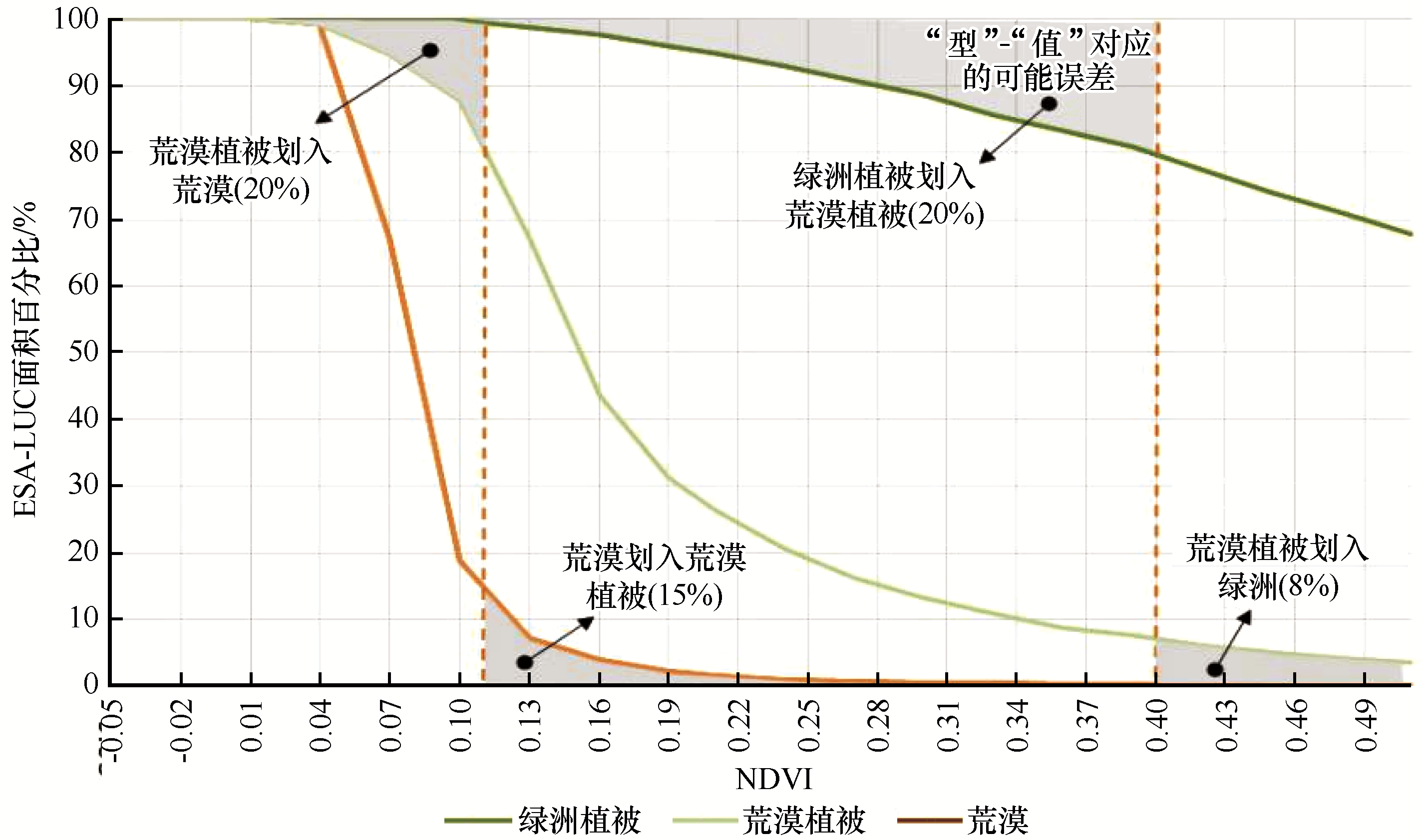
Fig.2 Conceptual framework of the "Type-Value" correspondance for reclassification of desert-oasis system along with the distribution of possible errors
| 分区 | 绿洲-荒漠植被 | 荒漠植被-荒漠 |
|---|---|---|
| 石羊河流域 | 0.48 | 0.12 |
| 黑河流域 | 0.45 | 0.12 |
| 玛纳斯河流域 | 0.44 | 0.22 |
| 阿克苏河流域 | 0.43 | 0.15 |
| 西北干旱区 | 0.40 | 0.11 |
Table 3 NDVI thresholds for reclassification of the desert-oasis systems
| 分区 | 绿洲-荒漠植被 | 荒漠植被-荒漠 |
|---|---|---|
| 石羊河流域 | 0.48 | 0.12 |
| 黑河流域 | 0.45 | 0.12 |
| 玛纳斯河流域 | 0.44 | 0.22 |
| 阿克苏河流域 | 0.43 | 0.15 |
| 西北干旱区 | 0.40 | 0.11 |
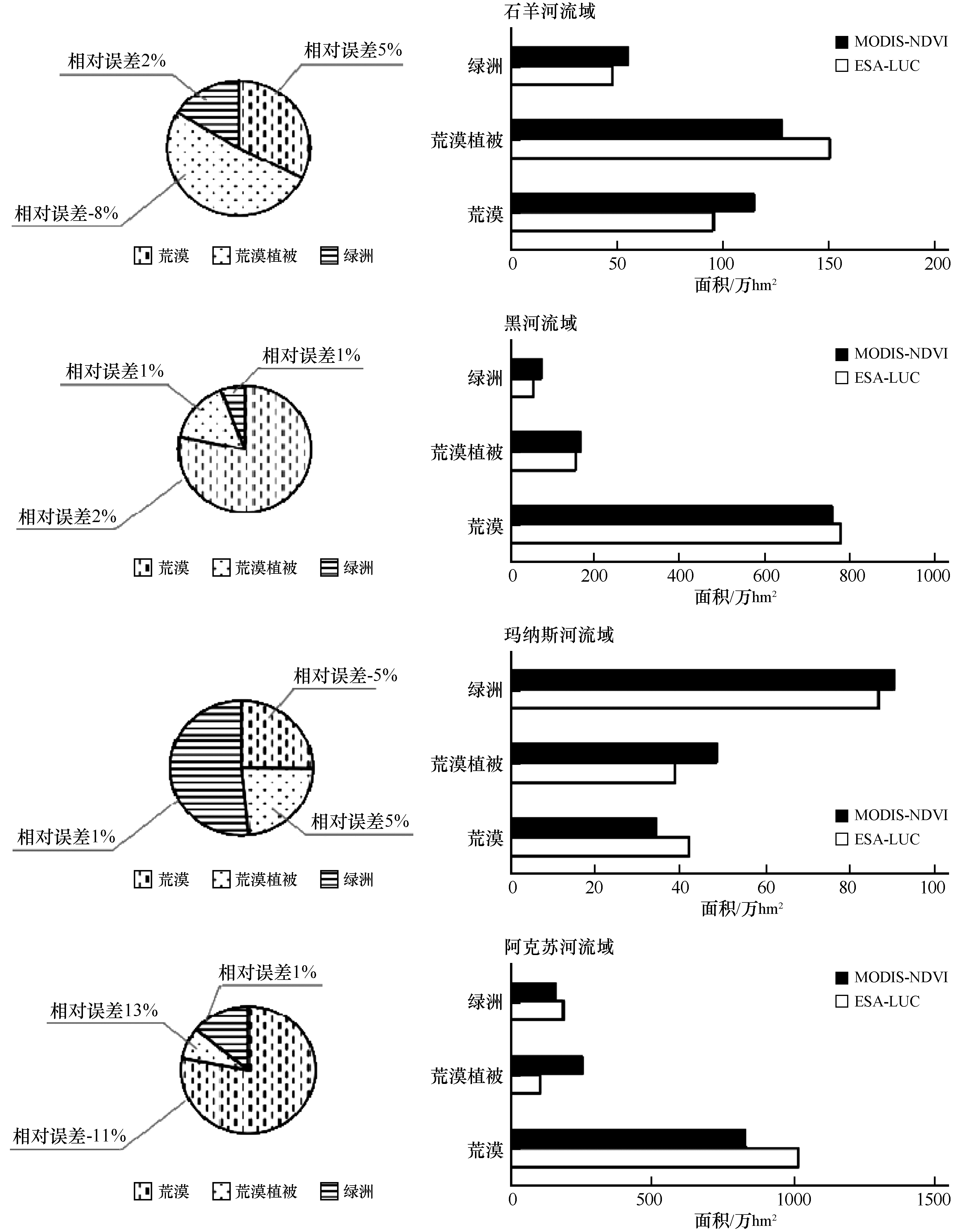
Fig.3 Precision assessment of the reclassification thresholds for the desert-oasis systems
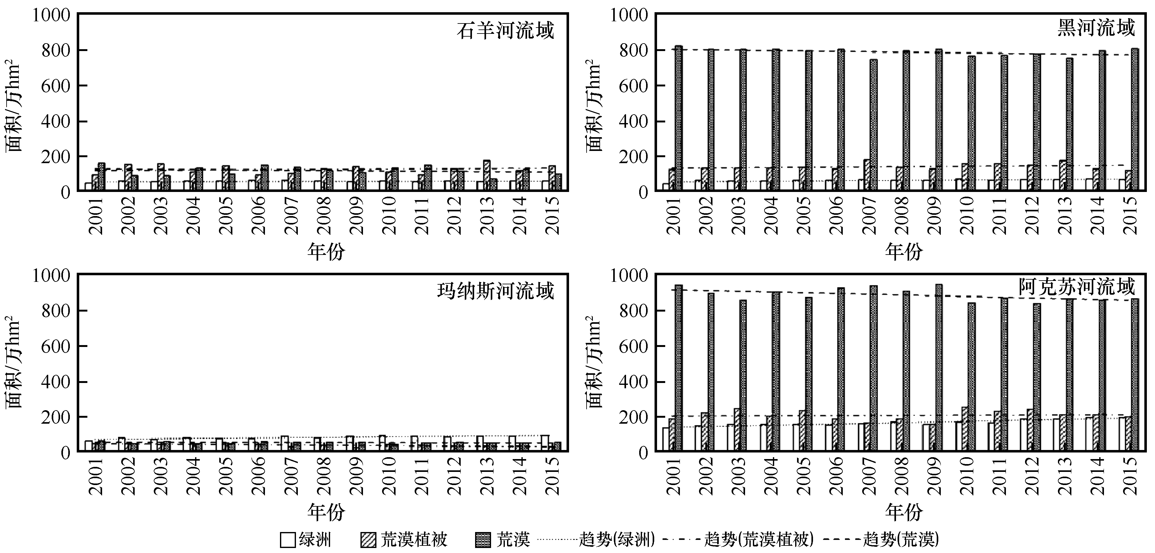
Fig.4 LUC variation trends in the desert-oasis systems of the four representative regions(2001—2015)
| 动态类型 | 植被类型 | 区域 | ||||
|---|---|---|---|---|---|---|
| 石羊河流域 | 黑河 流域 | 玛纳斯河流域 | 阿克苏河流域 | 西北干旱区 | ||
| 单一 动态度 | 绿洲植被 | 2.03 | 3.49 | 2.86 | 2.88 | 2.15 |
| 荒漠植被 | 8.08 | 0.58 | -0.44 | 3.17 | 1.56 | |
| 荒漠 | -5.52 | -0.25 | -3.20 | -1.07 | 1.15 | |
| 综合 动态度 | 2.90 | 0.73 | 1.62 | 0.94 | 0.74 | |
Table 3 Vegetation dynamics in the arid NWC and the four representative areas (2001 to 2015)
| 动态类型 | 植被类型 | 区域 | ||||
|---|---|---|---|---|---|---|
| 石羊河流域 | 黑河 流域 | 玛纳斯河流域 | 阿克苏河流域 | 西北干旱区 | ||
| 单一 动态度 | 绿洲植被 | 2.03 | 3.49 | 2.86 | 2.88 | 2.15 |
| 荒漠植被 | 8.08 | 0.58 | -0.44 | 3.17 | 1.56 | |
| 荒漠 | -5.52 | -0.25 | -3.20 | -1.07 | 1.15 | |
| 综合 动态度 | 2.90 | 0.73 | 1.62 | 0.94 | 0.74 | |
| 统计区 | P≤0.05 | P>0.05 | |
|---|---|---|---|
| SS>0 | SS<0 | 不显著 | |
| 石羊河流域 | 13 | 7 | 80 |
| 黑河流域 | 26 | 12 | 62 |
| 玛纳斯河流域 | 33 | 11 | 56 |
| 阿克苏河流域 | 11 | 17 | 72 |
| 西北干旱区 | 8 | 10 | 82 |
Table 4 Areal proportions based on statistical significance and Sen’s slope tested NDVI variations (%)
| 统计区 | P≤0.05 | P>0.05 | |
|---|---|---|---|
| SS>0 | SS<0 | 不显著 | |
| 石羊河流域 | 13 | 7 | 80 |
| 黑河流域 | 26 | 12 | 62 |
| 玛纳斯河流域 | 33 | 11 | 56 |
| 阿克苏河流域 | 11 | 17 | 72 |
| 西北干旱区 | 8 | 10 | 82 |
| 植被稳定性 | 植被类型 | 区域 | |||
|---|---|---|---|---|---|
| 石羊河流域 | 黑河流域 | 玛纳斯河流域 | 阿克苏河流域 | ||
| 稳定区 | 绿洲植被 | 34(11%) | 42(4%) | 52(31%) | 107(9%) |
| 荒漠植被 | 42(14%) | 58(6%) | 4(2%) | 48(3%) | |
| 荒漠 | 43(14%) | 662(66%) | 32(18%) | 690(55%) | |
| 变化区 | 180(60%) | 240(24%) | 85(49%) | 409(33%) | |
Table 5 Areal statistics of the stable and the unstable regions (104 hm2)
| 植被稳定性 | 植被类型 | 区域 | |||
|---|---|---|---|---|---|
| 石羊河流域 | 黑河流域 | 玛纳斯河流域 | 阿克苏河流域 | ||
| 稳定区 | 绿洲植被 | 34(11%) | 42(4%) | 52(31%) | 107(9%) |
| 荒漠植被 | 42(14%) | 58(6%) | 4(2%) | 48(3%) | |
| 荒漠 | 43(14%) | 662(66%) | 32(18%) | 690(55%) | |
| 变化区 | 180(60%) | 240(24%) | 85(49%) | 409(33%) | |
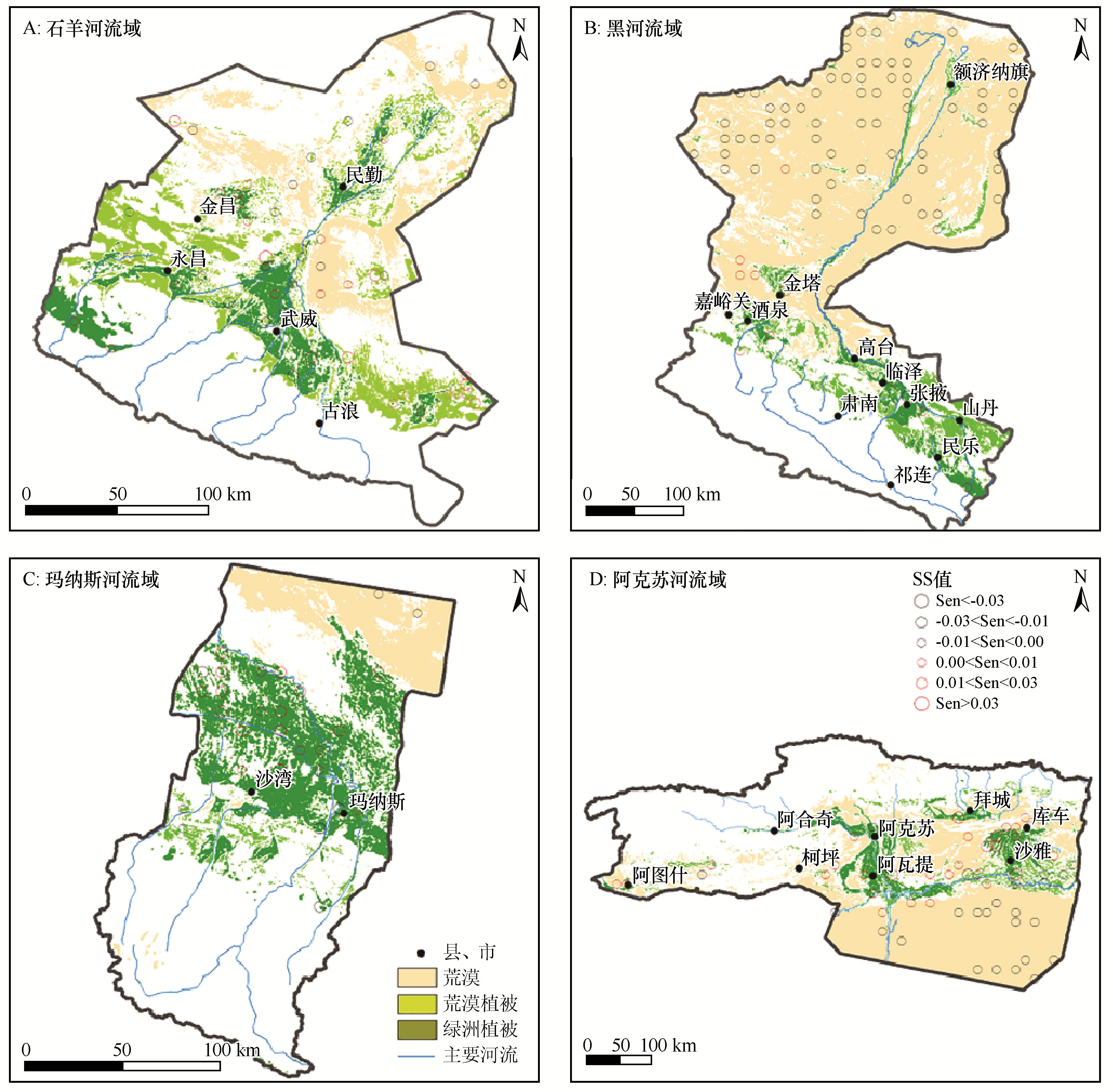
Fig.5 Land cover distribution of the stable area along with the SS tested NDVI variation in space

Fig.6 Land cover distribution of the unstable area along with the SS tested NDVI variation in space
| 1 | 李秀彬.全球环境变化研究的核心领域:土地利用/土地覆被变化的国际研究动向[J].地理学报,1996,63(6):553-558. |
| 2 | 华文剑,陈海山,李兴.中国土地利用/覆盖变化及其气候效应的研究综述[J].地球科学进展,2014,29(9):1025-1036. |
| 3 | 热伊莱·卡得尔,玉苏甫·买买提,玉素甫江·如素力.伊犁河谷2001—2014年地表温度时空分异特征[J].中国沙漠,2018,38(3):637-644. |
| 4 | 刘纪远,刘明亮,庄大方,等.中国近期土地利用变化的空间格局分析[J].中国科学:地球科学,2002,32(12):1031-1040. |
| 5 | 李常斌,杨林山,杨文瑾,等.洮河流域土地利用/土地覆被变化及其驱动机制研究[J].地理科学,2014,34(7):849-855. |
| 6 | 陈曦,罗格平.干旱区绿洲生态研究及其进展[J].干旱区地理,2008,31(4):487-495. |
| 7 | 穆桂金,贺俊霞,雷加强,等.再议绿洲-沙漠过渡带:以策勒绿洲-沙漠过渡带为例[J].干旱区地理,2013,36(2):195-202. |
| 8 | 徐学选,张北赢,白晓华.黄土丘陵区土壤水资源与土地利用的耦合研究[J].水土保持学报,2007,21(3):166-169. |
| 9 | 王根绪,杨玲媛,陈玲,等.黑河流域土地利用变化对地下水资源的影响[J].地理学报,2005,60(3):456-466. |
| 10 | 马心依,粟晓玲,张更喜.基于归一化植被指数估算黑河中游地区植被生态耗水量[J].西北农林科技大学学报(自然科学版),2018,46(8):55-62. |
| 11 | 张飞,郭玉川,姜红涛,等.气候和土地利用/覆盖变化对渭干河-库车河三角洲绿洲水资源的影响[J].湖北农业科学,2014,53(23):5716-5723. |
| 12 | 汪松,王斌,刘长征,等.利用Landsat时序NDVI数据进行新疆石河子垦区灌溉作物分类[J].测绘通报,2016(9):56-59. |
| 13 | 齐善忠,罗芳,肖洪浪.干旱内陆河流域土地利用变化及其对环境的影响:以西北地区黑河流域为例[J].生态环境,2006,15(4):757-760. |
| 14 | 贾珍珍,巩杰,张影.近35 a来疏勒河中下游绿洲化-荒漠化时空变化[J].干旱区研究,2016,33(6):1294-1302. |
| 15 | 谢家丽,颜长珍,李森,等.近35 a内蒙古阿拉善盟绿洲化过程遥感分析[J].中国沙漠,2012,32(4):1142-1147. |
| 16 | 王长耀,骆成凤,齐述华,等.NDVI-Ts空间全国土地覆盖分类方法研究[J].遥感学报,2005,9(1):93-99. |
| 17 | 马丽,徐新刚,刘良云,等.基于多时相NDVI及特征波段的作物分类研究[J].遥感技术与应用,2008,23(5):520-524. |
| 18 | 焦伟,陈亚宁,李稚.西北干旱区植被净初级生产力的遥感估算及时空差异原因[J].生态学杂志,2017,36(1):181-189. |
| 19 | 王万瑞,王刘明,张雪蕾,等.1956—2015年洮河径流演变特征研究[J].西北师范大学学报(自然科学版),2018,54(1):92-99. |
| 20 | 杨林山,李常斌,王帅兵,等.气候变化和人类活动对洮河流域植被动态的影响研究[J].资源科学,2014,36(9):1941-1948. |
| 21 | 杨林山,李常斌,王帅兵,等.洮河流域潜在蒸散发的气候敏感性分析[J].农业工程学报,2014,30(11):102-109. |
| 22 | Li C,Wang L,Wang W,et al.An analytical approach to separate climate and human contributions to basin streamflow variability[J].Journal of Hydrology,2018,559(12):30-42. |
| 23 | Sen P K.Estimates of the regression coefficient based on Kendall’s tau[J].Journal of the American Statistical Association,1968,63(324):1379-1389. |
| 24 | 张立峰,闫浩文,杨树文,等.黑河流域植被覆盖变化及其对地形的响应[J].遥感信息,2018,33(2):46-52. |
| 25 | 钱金波.基于MODIS数据的石羊河流域植被动态变化分析[J].中国科技信息,2013(12):40-41. |
| 26 | Duan C,Wu L,He L,et al.Spatio-temporal distribution pattern of vegetation coverage in Junggar Basin,Xinjiang[J]. Acta Ecologica Sinica,2016,36(2):72-76. |
| 27 | 张辉,刘江华,张超.阿克苏河流域不同植被类型NDVI时空变化特征[J].水资源与水工程学报,2017,28(4):88-92. |
| 28 | 何朝霞.基于指数的决策树土地利用分类算法研究[J].湖北农业科学,2019,58(21):176-180. |
| 29 | 李庆,史敏伟.基于随机森林的多时相Landsat8土地利用分类研究[J].信息技术与信息化,2019(7):181-183. |
| 30 | 高鑫,徐景东,冯阳,等.基于遥感与GIS的土地利用分类方法研究:以河北省安新县为例[J].科技创新与应用,2019,263(7):116-118. |
| 31 | 李玲萍,杨永龙,钱莉.石羊河流域近45年气温和降水特征分析[J].干旱区研究,2008,25(5):705-710. |
| 32 | 李玲萍,刘明春.石羊河流域出山口河流流量的变化趋势及特性分析[J].水土保持学报,2011,25(1):58-63. |
| 33 | 高宇,袁勇,方宏阳,等.近50年黑河流域降水变化特征分析[J].南水北调与水利科技,2013,11(5):16-21. |
| 34 | 李振朝,韦志刚,吕世华,等.河西地区绿洲NDVI的演变特征及与气候因子的关系分析[J].干旱区地理,2008,31(1):82-87. |
| 35 | Jin X,Guangcheng H U,Wenmei L I.Hysteresis effect of runoff of the Heihe River on vegetation cover in the Ejina Oasis in Northwestern China[J].Earth Science Frontiers,2008,15(4):198-203. |
| 36 | 魏波.玛纳斯河流域径流及气候变化趋势分析[J].北京农业,2014(15):184-189. |
| 37 | 高惠芸,杨青,梁岩鸿.新疆阿克苏河流域降水的时空分布[J].干旱区研究,2008,25(1):70-74. |
| 38 | 刘新春,杨青,梁云.近40年阿克苏河流域径流变化特征及影响因素研究[J].中国人口·资源与环境,2006,16(3):82-87. |
| 39 | 段峥嵘,祖拜代·木依布拉,夏建新.基于NDVI的干旱区绿洲植被覆盖度动态变化分析:以新疆阿克苏地区为例[J].中央民族大学学报(自然科学版),2018,27(2):1-5. |
| [1] | Jun Lei, Xiaohu Yang, Hongmei Liu, Yuhong Zhao, Juping Fan, Caixia Guo. The characteristics of desert vegetation biomass and its influencing factors in the middle reaches of the Heihe River [J]. Journal of Desert Research, 2021, 41(1): 203-208. |
| [2] | Mengyu Hao, Longjun Qin, Peng Mao, Jiechunyi Luo, Wenli Zhao, Guoyu Qiu. Unmanned aerial vehicle (UAV) based methodology for spatial distribution pattern analysis of desert vegetation [J]. Journal of Desert Research, 2020, 40(6): 169-179. |
| [3] | Li Yike, Zhao Chengyi, Yang Ruihong. Intraspecific Competition of Haloxylon ammodendron in the Southern Margin of Junggar Basin [J]. JOURNAL OF DESERT RESEARCH, 2016, 36(2): 335-341. |
| [4] | Deng Yulin, Tashpolat Tiyip, Jiang Hongtao, Zhang Fei, Mamat Sawut, Nurmamatjan Obulkasim. NDVI at a Vertical Gradient in the Ebinur Lake Basin, Xinjiang, China [J]. JOURNAL OF DESERT RESEARCH, 2015, 35(2): 508-513. |
| [5] | Jiang Hongtao, Tashpolat·Tiyip, Ardak·Kelimu, Zhang Fei, Mamat·Sawut, Wu Xuemei. Responses of NDVI to the Variation of Precipitation and Temperature in the Ebinur Lake Basin [J]. JOURNAL OF DESERT RESEARCH, 2014, 34(6): 1678-1684. |
| [6] | Zhong Zebing, Zhou Guoying, Yang Lucun, Liu Hechun, Song Wenzhu. The Biomass Allocation Patterns of Desert Shrub Vegetation in the Qaidam Basin, Qinghai, China [J]. JOURNAL OF DESERT RESEARCH, 2014, 34(4): 1042-1048. |
| [7] | XI Hai-yang, FENG Qi, SI Jian-hua, CHANG Zong-qiang, SU Yong-hong. Response of NDVI to Groundwater Level Change in the Lower Reaches of the Heihe River, China [J]. JOURNAL OF DESERT RESEARCH, 2013, 33(2): 574-582. |
| [8] | ZHAO Jin;CHEN Xi;Guli Japper;MA Zhong-guo;CHANG Cun;. Spectral Discrimination of Desert Vegetation in the Tarim River Basin [J]. JOURNAL OF DESERT RESEARCH, 2009, 29(2): 270-278. |
| [9] | ZHANG Kai;SI Jian-hua;WANG Run-yuan;WANG Xiao-ping;HAN Hai-tao;GUO Ni. Impact of Climate Change on Desert Vegetation in Alxa Region [J]. JOURNAL OF DESERT RESEARCH, 2008, 28(5): 879-885. |
| [10] | ZHANG Jin-chun;ZHAO Ming;LIAO Kong-tai;XU Yan-shuang;ZHANG Ying-chang. Experimental Research on Desert Vegetation Restoration by Drip Irrigation at Minqin Oasis Edge [J]. JOURNAL OF DESERT RESEARCH, 2007, 27(1): 94-98. |
| [11] | WANG Ji-he;MA Quan-lin;LIU Hu-jun;YANG Zi-hui;ZHANG De-kui. Effect of Wind-breaking and Sand-fixing of Vegetation in Progressive Succession on Desertification Land in Arid Area [J]. JOURNAL OF DESERT RESEARCH, 2006, 26(6): 908-909. |
| [12] | XIAO Sheng-chun;XIAO Hong-lang;SONG Yao-xuan;DUAN Zheng-hu;LU Ming-feng. Dendrochronology Study on Response of Reaumurta soongorica to Water-Heat Variation [J]. JOURNAL OF DESERT RESEARCH, 2006, 26(4): 548-552. |
| [13] | YANG Zi hui. Research on Desert Vegetation Changes for 40 Years at Shajingzi Area in Minqin [J]. JOURNAL OF DESERT RESEARCH, 1999, 19(4): 395-398. |
| Viewed | ||||||
|
Full text |
|
|||||
|
Abstract |
|
|||||
©2018Journal of Desert Research
Tel:0931-8267545
Email:caiedit@lzb.ac.cn;desert@lzb.ac.cn
Support:Magtech