
- CN 62-1070/P
- ISSN 1000-694X
- Bimonthly 1981
Journal of Desert Research ›› 2021, Vol. 41 ›› Issue (1): 183-194.DOI: 10.7522/j.issn.1000-694X.2020.00089
Previous Articles Next Articles
Xuyang Wang( ), Yulin Li(), Jie Lian, Yulong Duan, Lilong Wang
Received:2020-06-10
Revised:2020-09-03
Online:2021-01-29
Published:2021-01-29
Contact:
Yulin Li
CLC Number:
Xuyang Wang, Yulin Li, Jie Lian, Yulong Duan, Lilong Wang. Relationship between vegetation coverage and climate change in semi-arid sandy land and the significance to ecological construction[J]. Journal of Desert Research, 2021, 41(1): 183-194.
Add to citation manager EndNote|Ris|BibTeX
URL: http://www.desert.ac.cn/EN/10.7522/j.issn.1000-694X.2020.00089
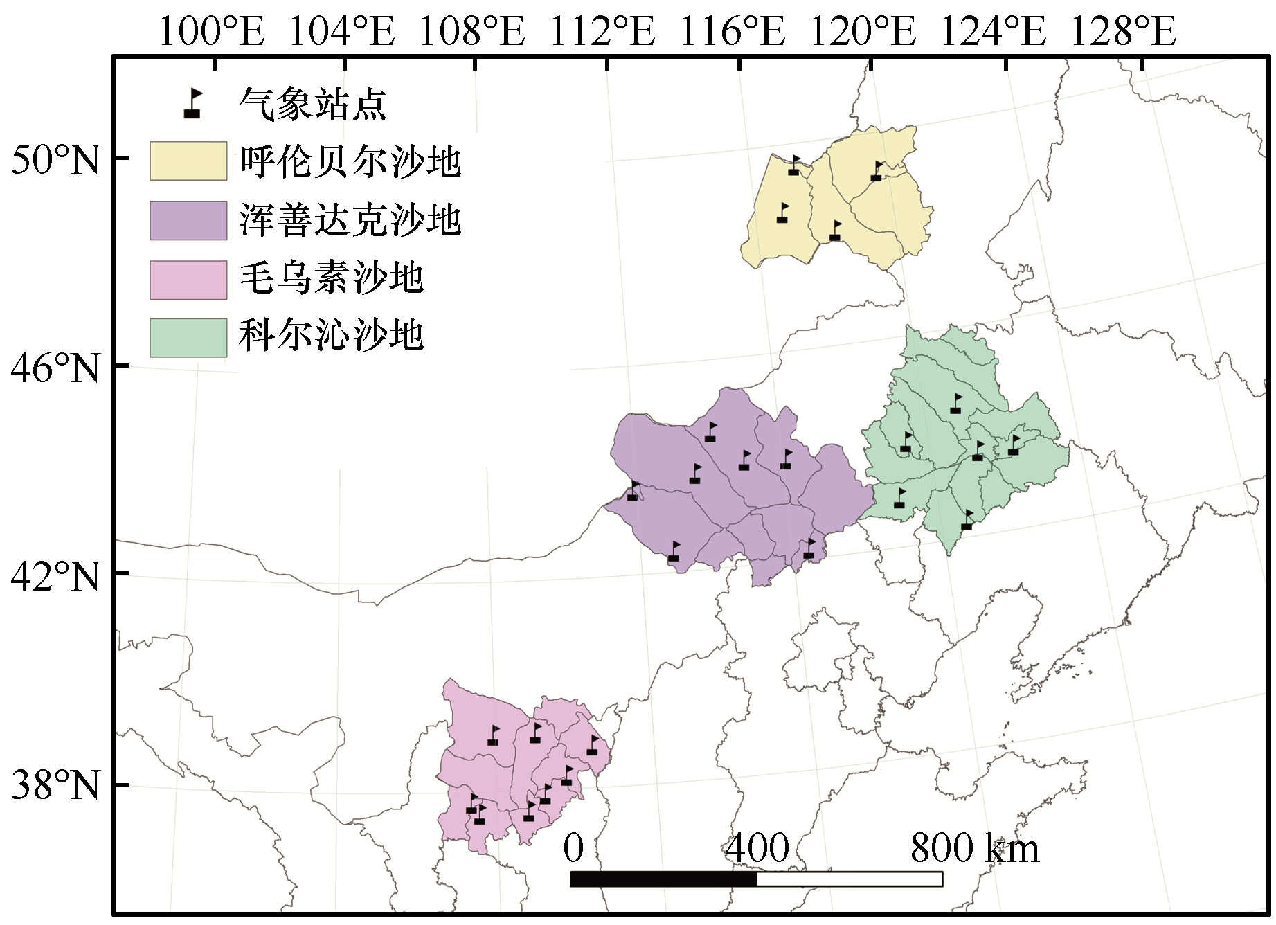
Fig.1 Location of the study area
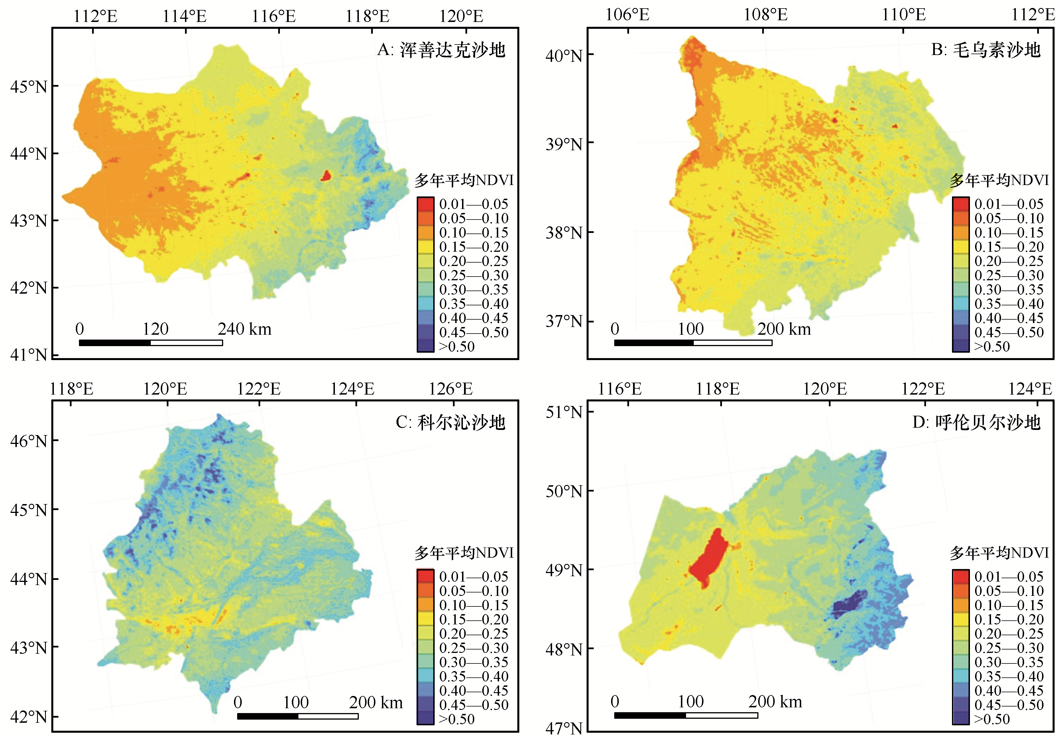
Fig.2 Spatial distribution of the multi-year mean normalized-difference vegetation index (NDVI) in semi-arid sandy land of China from 1998 to 2018
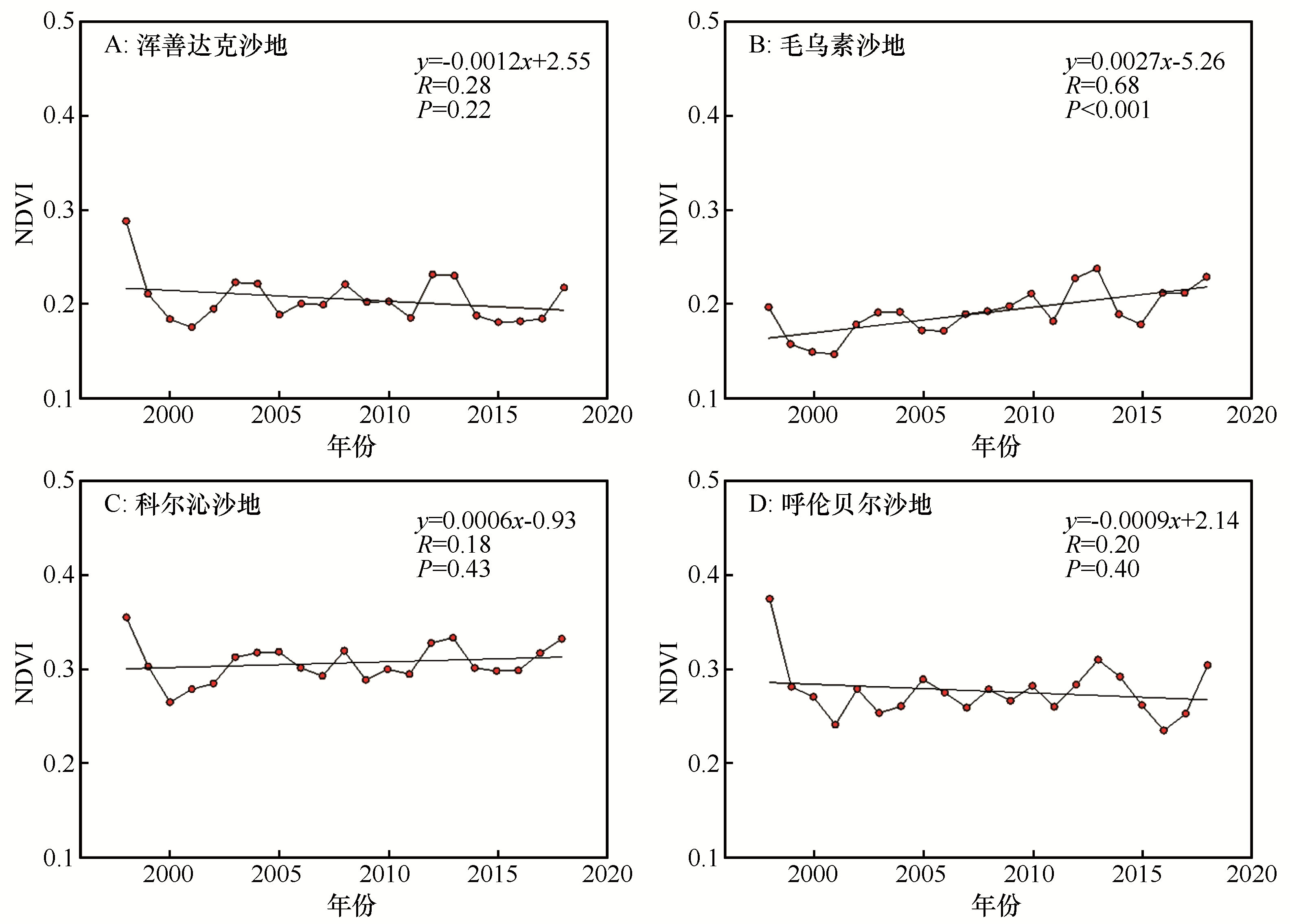
Fig.3 The inter-annual variations of the normalized-difference vegetation index (NDVI) in semi-arid sandy land of China from 1998 to 2018

Fig.4 Spatial pattern change of the normalized-difference vegetation index (NDVI) in semi-arid sandy land of China from 1998 to 2018
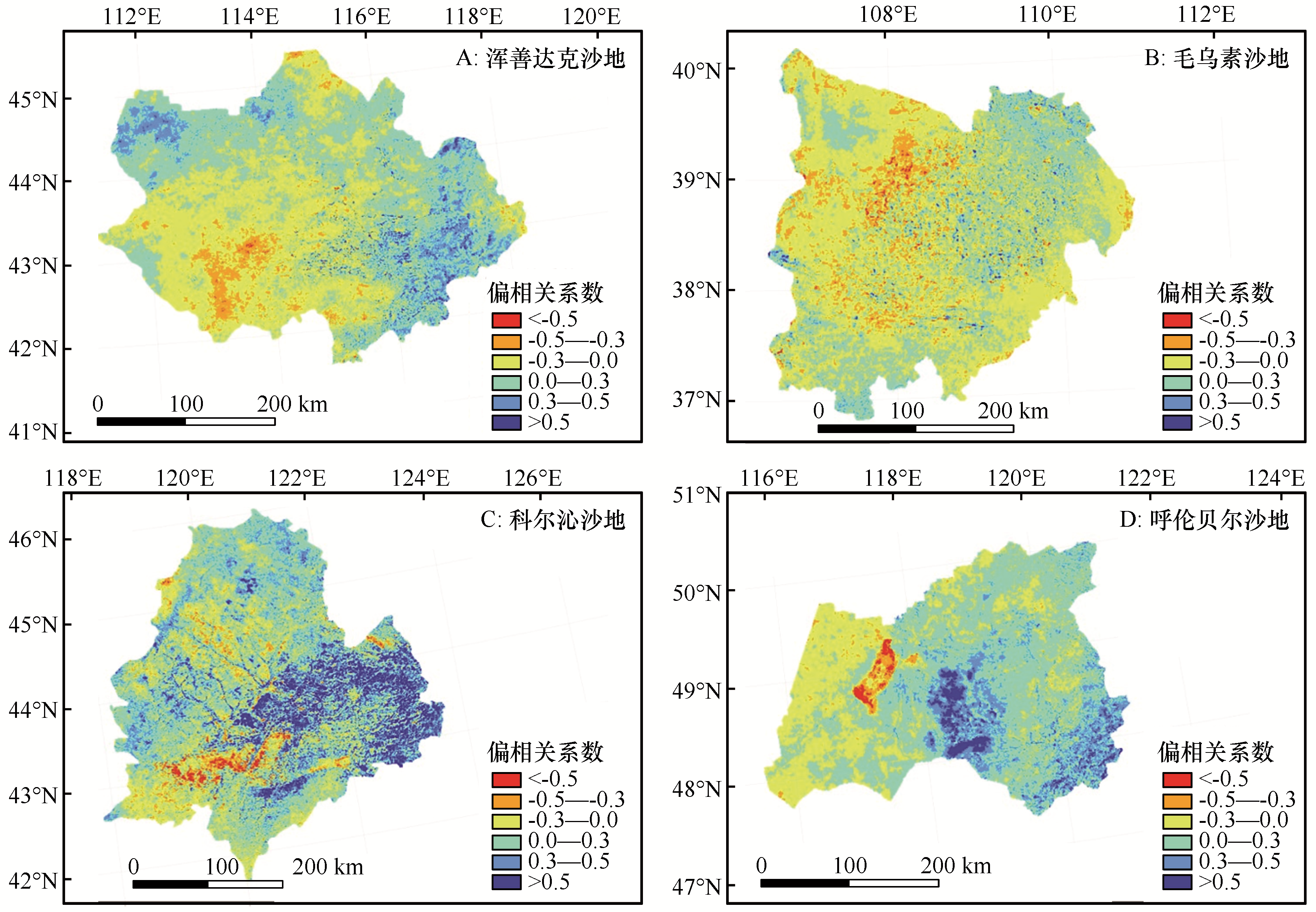
Fig.5 Spatial distribution of partial correlations between the multi-year mean normalized-difference vegetation index (NDVI) and the mean annual temperature in semi-arid sandy land of China from 1998 to 2018
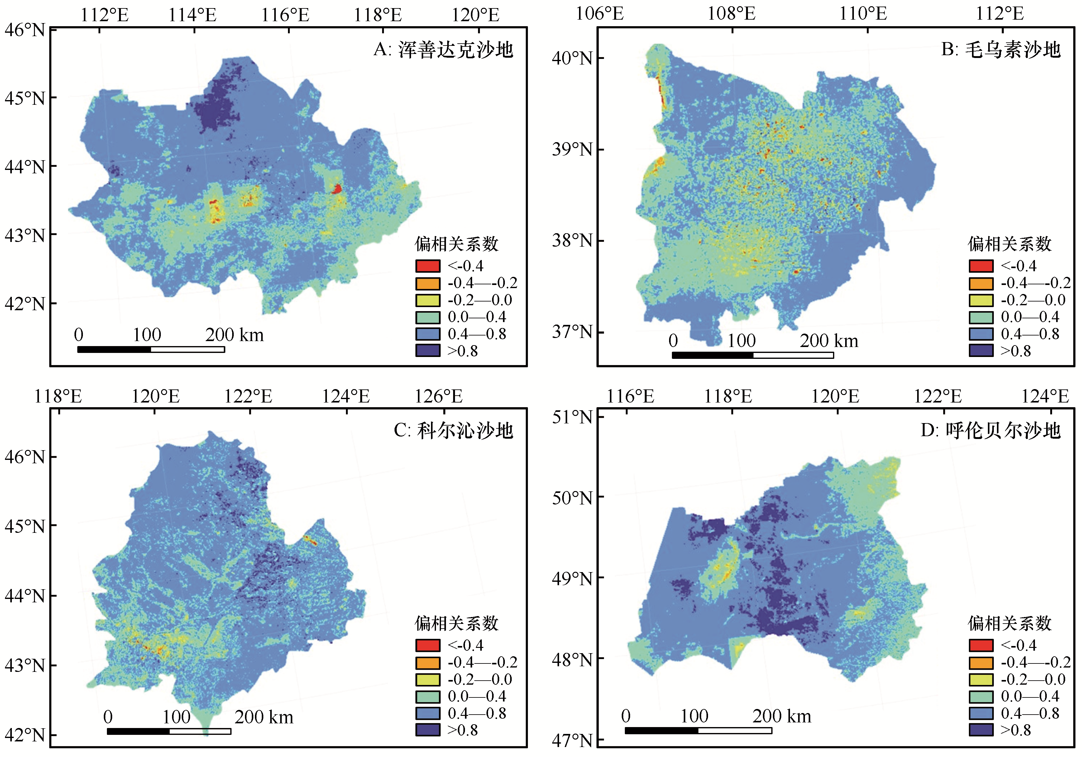
Fig.6 Spatial distribution of partial correlations between the multi-year mean normalized-difference vegetation index (NDVI) and the mean total annual precipitation in semi-arid sandy land of China from 1998 to 2018

Fig.7 Spatial distribution of the multiple-correlation coefficient between the multi-year mean normalized-difference vegetation index (NDVI) and the two climate drivers (temperature and precipitation) in semi-arid sandy land of China from 1998 to 2018
| NDVI变化驱动因子 | C1 | C2 | C3 | |
|---|---|---|---|---|
| 气候因子 | [T+P]+ | P < 0.01 | P < 0.01 | P < 0.05 |
| T | P < 0.01 | P ≥ 0.01 | P < 0.05 | |
| P | P ≥ 0.01 | P < 0.01 | P < 0.05 | |
| [T+P] | P ≥ 0.01 | P ≥ 0.01 | P < 0.05 | |
| 非气候因子 | NC | P ≥ 0.01 | P ≥ 0.01 | P ≥ 0.05 |
Table 1 The criteria used for classification of the driving factors for dynamic changes of the normalized-difference vegetation index (NDVI).
| NDVI变化驱动因子 | C1 | C2 | C3 | |
|---|---|---|---|---|
| 气候因子 | [T+P]+ | P < 0.01 | P < 0.01 | P < 0.05 |
| T | P < 0.01 | P ≥ 0.01 | P < 0.05 | |
| P | P ≥ 0.01 | P < 0.01 | P < 0.05 | |
| [T+P] | P ≥ 0.01 | P ≥ 0.01 | P < 0.05 | |
| 非气候因子 | NC | P ≥ 0.01 | P ≥ 0.01 | P ≥ 0.05 |

Fig.8 Spatial distribution of the effects of the driving factors on changes in the multi-year normalized-difference vegetation index (NDVI) in semi-arid sandy land of China from 1998 to 2018
| 指数 | 呼伦贝尔沙地 | 浑善达克沙地 | 科尔沁沙地 | 毛乌素沙地 |
|---|---|---|---|---|
| CWD | 0.429** | 0.362** | 0.068 | 0.138 |
| CDD | -0.225 | -0.264** | -0.004 | -0.189* |
Table 2 Correlation between normalized-difference vegetation index (NDVI) and extreme precipitation index
| 指数 | 呼伦贝尔沙地 | 浑善达克沙地 | 科尔沁沙地 | 毛乌素沙地 |
|---|---|---|---|---|
| CWD | 0.429** | 0.362** | 0.068 | 0.138 |
| CDD | -0.225 | -0.264** | -0.004 | -0.189* |
| 1 | 李广清.人类面对荒漠化的问题应采取的对策[J].中国环境管理干部学院学报,2004(3):65-67. |
| 2 | 王涛,吴薇,薛娴,等.近50年来中国北方沙漠化土地的时空变化[J].地理学报,2004(2):203-212. |
| 3 | 尚可政,董光荣,王式功,等.我国北方沙区气候变化对全球变暖的响应[J].中国沙漠,2001,21(4):72-77. |
| 4 | 朱芳莹,鹿化煜,弋双文,等.基于NDVI指数的浑善达克沙地植被时空变化规律分析[J].中国水土保持,2017(3):31-34,69. |
| 5 | 赵哈林,赵学勇,张铜会.我国北方农牧交错带沙漠化的成因、过程和防治对策[J].中国沙漠,2000,20():23-29. |
| 6 | 薛娴,王涛,吴薇,等.中国北方农牧交错区沙漠化发展过程及其成因分析[J].中国沙漠,2005,25(3):320-328. |
| 7 | 蒋卫国,陈云浩,李京,等.中国北方农牧交错带生态环境的空间格局演变[J].自然资源学报,2005(6):77-84. |
| 8 | Wang X Y,Li Y Q,Gong X W,et al.Storage,pattern and driving factors of soil organic carbon in an ecologically fragile zone of northern China[J].Geoderma,2019,343:155-165. |
| 9 | Sun W,Song X,Mu X,et al.Spatiotemporal vegetation cover variations associated with climate change and ecological restoration in the loess plateau[J].Agricultural and Forest Meteorology,2015,209(1):87-99. |
| 10 | Liu X,Zhou W,Bai Z.Vegetation coverage change and stability in large open-pit coal mine dumps in China during 1990-2015[J].Ecological Engineering,2016,95:447-451. |
| 11 | Fung T,Siu W.Environmental quality and its changes,an analysis using NDVI[J].International Journal of Remote Sensing,2000,21:1011-1024. |
| 12 | Pettorelli N,Vik J O,Mysterud A,et al.Using the satellite-derived NDVI to assess ecological responses to environmental change[J].Trends in Ecology & Evolution,2005,20:503-510. |
| 13 | Clerici N,Weissteiner C J,Gerard F.Exploring the use of MODIS NDVI-based phenology indicators for classifying forest general habitat categories[J].Remote Sensing,2012,4(6):1781-1803. |
| 14 | Feng L,Guo S,Zhu L,et al.Urban vegetation phenology analysis using high spatio-temporal NDVI time series[J].Urban Forestry & Urban Greening,2017,25:43-57. |
| 15 | Wardlow B D,Egbert S L.Large-area crop mapping using time-series MODIS 250 m NDVI data:an assessment for the U.S.Central Great Plains[J].Remote Sensing of Environment,2008,112:1096-1116. |
| 16 | Magney T S,Eitel J U H,Huggins D R,et al.Proximal NDVI derived phenology improves in-season predictions of wheat quantity and quality[J].Agricultural & Forest Meteorology,2016,217:46-60. |
| 17 | Pei H,Zhang S Y,Ao Y Q.Research on climate and climatic changes in Hunshandake Sandy Land[J].Land Meteorological Science and Technology,2005,33(1):63-67. |
| 18 | 张广才,于卫平,刘伟泽,等.毛乌素沙地不同治理措施植被恢复效果分析[J].林业科学研究,2004(B12):1-9. |
| 19 | Piao S L,Mohammat A,Fang J Y,et al.NDVI-based increase in growth of temperate grasslands and its responses to climate changes in China[J].Global Environmental Change,2006,16:340-348. |
| 20 | Schucknecht A,Erasmi S,Niemeyer I,et al.Assessing vegetation variability and trends in north-eastern Brazil using AVHRR and MODIS NDVI time series[J].European Journal of Remote Sensing,2013,46(1):40-59. |
| 21 | An Y,Gao W,Gao Z,et al.Assessment of desertification in the agro-pastoral transitional zone in Northern China (1982-2006) using GIMMS NDVI data[J].Remote Sensing and Modeling of Ecosystems for Sustainability,2015,8869:886913. |
| 22 | Miao L J,Ye P L,He B,et al.Future climate impact on the desertification in the dry land Asia using AVHRR GIMMS NDVI3g data[J].Remote Sensing,2015,7:3863-3877. |
| 23 | Gezahagn N S.Spatial assessment of NDVI as an Indicator of Desertification in Ethiopia Using Remote Sensing and GIS[D].Master degree thesis,30/credits in Master in Geographical Information Science Department of Physical Geography and Ecosystem Science, Lund University,2016. |
| 24 | Fathizad H,Ardakani M A H,Mehrjardi R T,et al.Evaluating desertification using remote sensing technique and object-oriented classification algorithm in the Iranian central desert[J].Journal of African Earth Sciences,2018,145(SEP):115-130. |
| 25 | 王涛.中国沙漠与沙漠化[M].石家庄:河北科学技术出版社,2003:525-574. |
| 26 | 闫峰,吴波.近40 a毛乌素沙地荒漠化过程研究[J].干旱区地理,2013,36(6):987-996. |
| 27 | 张宝珠,金维林,葛士林,等.呼伦贝尔沙地治理布局及治理模式[J].中国沙漠,2013,33(5):1310-1313. |
| 28 | 李春兰,朝鲁门,包玉海,等.21世纪初期气候波动下浑善达克沙地荒漠化动态变化分析[J].干旱区地理,2015,38(3):556. |
| 29 | 王旭洋,李玉强,罗永清,等.科尔沁沙地不同生境植被凋落物年际及年内动态[J].应用生态学报,2018,29(5):124-132. |
| 30 | 于娜,赵媛媛,丁国栋,等.基于生态足迹的中国四大沙地地区可持续评价[J].干旱区地理,2018,41(6):170-180. |
| 31 | Purevdorj T,Tateishi R,Ishiyama T,et al.Relationships between percent vegetation cover and vegetation indices[J].International Journal of Remote Sensing,1998,19:3519-3535. |
| 32 | Stow D,Petersen A,Hope A,et al.Greenness trends of Arctic tundra vegetation in the 1990s:comparison of two NDVI data sets from NOAA AVHRR systems[J].International Journal of Remote Sensing,2007,28:4807-4822. |
| 33 | 方精云,朴世龙,贺金生,等.近20年来中国植被活动在增强[J].中国科学(C辑),2003,33(6):554-565. |
| 34 | 李月臣,宫鹏,刘春霞,等.北方13省1982-1999年植被变化及其与气候因子的关系[J].资源科学,2006,28(2):109-117. |
| 35 | 高志强,刘纪远,曹明奎,等.土地利用和气候变化对区域净初级生产力的影响[J].地理学报,2004,59(4):581-591. |
| 36 | 刘军会,高吉喜.气候和土地利用变化对北方农牧交错带植被NPP变化的影响[J].资源科学,2009,31(3):493-500. |
| 37 | Mohamed M A A,Babiker I S,Chen Z M,et al.The role of climate variability in the inter-annual variation of terrestrial net primary production (NPP)[J].Science of the Total Environment,2004,332(1/3):123-137. |
| 38 | 陈云浩,李晓兵,史培军.1983-1992年中国陆地NDVI变化的气候因子驱动分析[J].植物生态学报,2001,25(6):716-720. |
| 39 | Nemani R R,Keeling C D,Hashimot H,et al.Climate-driven increased in global terrestrial net primary production from 1982 to 1999[J].Science,2003,300:1560-1563. |
| 40 | Zhao X,Tan K,Zhao S,et al.Changing climate affects vegetation growth in the arid region of the northwest China[J].Journal of Arid Environments,2011,75:946-952. |
| 41 | 王涛,杨梅焕.榆林地区植被指数动态变化及其对气候和人类活动的响应[J].干旱区研究,2017,34(5):1133-1140. |
| 42 | 张戈丽,徐兴良,周才平,等.近30年来呼伦贝尔地区草地植被变化对气候变化的响应[J].地理学报,2011,66(1):47-58. |
| 43 | 邵艳莹.中国四大沙地植被动态变化及其对气候变化的响应[D].北京:北京林业大学,2018. |
| 44 | 杜加强,贾尔恒·阿哈提,赵晨曦,等.1982-2012年新疆NDVI的动态变化及其对气候变化和人类活动的响应[J].应用生态学报,2015,26(12):3567-3578. |
| 45 | De Jong R,Verbesselt J,Schaepman M E,et al.Trend changes in global greening and browning:contribution of short-term trends to longer-term change[J].Global Chang Biology,2012,18:642-655. |
| 46 | Wessels K J,van den Bergh F,Scholes R J.Limits to detectability of land degradation by trend analysis of vegetation index data[J].Remote Sensing of Environment,2012,125:10-22. |
| 47 | Yang X,Ding Z,Fan X,et al.Processes and mechanisms of desertification in northern China during the last 30 years,with a special reference to the Hunshandake Sandy Land,eastern Inner Mongolia[J].Catena,2007,71(1):2-12. |
| 48 | 李震,阎福礼,范湘涛.中国西北地区NDVI变化及其温度和降水的关系[J].遥感学报,2005,9(3):308-313. |
| 49 | Li X R,Zhang Z S,Huang L,et al.Review of the ecohydrological processes and feedback mechanisms controlling sand-binding vegetation systems in sandy desert regions of China[J].Chinese Science Bulletin,2013,58(13):1483-1496. |
| 50 | Feng X,Fu B,Piao S,et al.Revegetation in China's Loess Plateau is approaching sustainable water resource limits[J].Nature Climate Change,2016,6(11):1019-1022. |
| 51 | Menz M H M,Dixon K W,Hobbs R J.Hurdles and opportunities for landscape-scale restoration[J].Science,2013,339(6119):526-527. |
| 52 | 安云.毛乌素沙地4种典型植被恢复模式生态效益分析[D].北京:北京林业大学,2013. |
| 53 | 边振,张克斌,李瑞,等.封育措施对宁夏盐池半干旱沙地草场植被恢复的影响研究[J].水土保持研究,2008,15(5):68-70. |
| 54 | 李维向,闫伟,刘朝霞,等.毛乌素沙区腹地提高飞播成效的技术措施研究[J].中国沙漠,2009,29(1):114-117. |
| 55 | 包雪原.浑善达克沙地植被恢复与重建途径研究[J].干旱区资源与环境,2004,18(8):128-132. |
| 56 | 彭羽.浑善达克沙地退化生态系统生态恢复的自然保护区途径[D].北京:中国科学院研究生院(植物研究所),2005. |
| 57 | 唐毅,蒋德明,陈雪峰,等.疏林草原榆树天然更新研究进展[J].中国沙漠,2011,31(5):1226-1230. |
| 58 | 李钢铁,姚云峰,张德英,等.科尔沁沙地疏林草原植被恢复技术体系[J].内蒙古农业大学学报(自然科学版),2005,26(3):1-6. |
| 59 | 郑翠玲,曹子龙,王贤,等.围栏封育在呼伦贝尔沙化草地植被恢复中的作用[J].中国水土保持科学,2005,3(3):78-81. |
| 60 | 吴锈钢,宋小东,王恩利,等.沙地樟子松人工林结构调整及更新改造技术措施[J].防护林科技,2002,53(4):82-83. |
| 61 | 刘康,王效科,杨帆,等.红花尔基地区沙地樟子松群落及其与环境关系研究[J].生态学杂志,2005,24(8):858-862. |
| 62 | 吕世海,卢欣石.呼伦贝尔草地风蚀沙化植被生物多样性研究[J].中国草地学报,2006,28(4):6-10. |
| 63 | 闫德仁,张宝珠.呼伦贝尔沙地研究综述[J].内蒙古林业科技,2008,34(3):34-39. |
| [1] | Yongxiang Cao, Donglei Mao, Fuyan Cai, Xuemei Wang, Abulaiti Kaimaierguli, Songling Su. Spatial difference of microclimate over typical underlying surface in process of oasisization in Cele, Xinjiang [J]. Journal of Desert Research, 2020, 40(6): 180-189. |
| [2] | Yu Peidong, Chen Yinping, Li Yuqiang, Yan Zhiqiang, Wang Xuyang, Niu Yayi, Gong Xiangwen. Influence of Vegetation Coverage on Sand Flow Structure and Wind Erosion Yield with Wind Tunnel Experiment as a Case [J]. Journal of Desert Research, 2019, 39(5): 29-36. |
| [3] | Liu Chan, Zhao Wenzhi, Liu Bing, Meng Yangyang. Distribution Characteristics and Dynamic Changes of Vegetation in Badain Jaran Desert: Based on UAV and MODIS Data [J]. Journal of Desert Research, 2019, 39(4): 92-102. |
| [4] | Cheng Long, Jia Xiaohong, Wu Bo, Li Yuanshou, Zhao Xuebin, Zhou Hong. Relationship between the Condensation Process of Hygroscopic and Condensate Water and the Air & Soil Humiture in Alpine Sandy Lands [J]. Journal of Desert Research, 2019, 39(3): 77-86. |
| [5] | Guo Zichen, Liu Shulin, Kang Wenping, Chen Xiang, Zhang Xueqin. Change Trend of Vegetation Coverage in the Mu Us Sandy Region from 2000 to 2015 [J]. Journal of Desert Research, 2018, 38(5): 1099-1107. |
| [6] | Li Lili, Wang Dawei, Han Tao. Spatial-temporal Dynamics of Vegetation Coverage and Responding to Climate Change in Shiyang River Basin during 2000-2015 [J]. Journal of Desert Research, 2018, 38(5): 1108-1118. |
| [7] | Liu Zhengyao, Dong Zhibao, Liu Yonglin, Cui Xujia, Xiao Weiqiang, Han Hongzhu. Conditions for the Development of Deserticulture in the Mu Us Sandy Land [J]. Journal of Desert Research, 2018, 38(4): 881-888. |
| [8] | Tan Fengzhu, Wang Xueqin, Wang Haifeng, Xu Junrong, Yuan Xinxin. Wind Tunnel Simulation of the Three-Dimensional Airflow Patterns around Tamarix ramosissima Nebkhas under the Change of Background Vegetation Coverage [J]. JOURNAL OF DESERT RESEARCH, 2018, 38(1): 48-57. |
| [9] | Su Yang, Qi Yuan, Wang Jianhua, Xu Feinan, Zhang Jinlong. Vegetation Coverage Classification and Vegetation Structure Parameters Extraction of Populus euphratica Forest in Ejina Oasis by LiDAR Data [J]. JOURNAL OF DESERT RESEARCH, 2017, 37(4): 689-697. |
| [10] | Feng Xiao, Li Shengyu, Xu Xinwen, Ma Xuexi, Xing Wenjuan, Yuan Xinxin. Wind Erosion and Deposition Features on Surfaces under Different Coverage of Alhagi sparsifolia Community in the Oasis-desert Ecotone in Cele, Xinjiang, China [J]. JOURNAL OF DESERT RESEARCH, 2016, 36(5): 1252-1259. |
| [11] | Bai Shuying, Wu Qi, Shi Jianqiao, Lu Yuan. Analysis on Vegetation Coverage Change in Shannan, Tibet, China Based on Remotely Sensed Data [J]. JOURNAL OF DESERT RESEARCH, 2015, 35(5): 1396-1402. |
| [12] | Zhang Hao, Qu Jianjun, Zhang Kecun. Vegetation Cover Information Extraction Technology for Dunhuang Oasis Based on Remote Sensing Images [J]. JOURNAL OF DESERT RESEARCH, 2015, 35(2): 493-498. |
| [13] | Liu Liangxu, Chang Xueli, Wang Wei, Yue Xiyuan, Gao Yuyi. Responses of Vegetation Area with Different Coverages to Precipitation Fluctuations in Desert Steppe [J]. JOURNAL OF DESERT RESEARCH, 2015, 35(2): 499-507. |
| [14] | Jin Xiaomei, Xia Wei, Guo Renhong. Variation of Vegetation Coverage in the Dulan Area of Qaidam River Basin [J]. JOURNAL OF DESERT RESEARCH, 2014, 34(2): 603-609. |
| [15] | LIU Xian-feng1, YANG Yong2, REN Zhi-yuan1, LIN Zhi-hui1. Changes of Vegetation Coverage in the Loess Plateau in 2000-2009 [J]. JOURNAL OF DESERT RESEARCH, 2013, 33(4): 1244-1249. |
| Viewed | ||||||
|
Full text |
|
|||||
|
Abstract |
|
|||||
©2018Journal of Desert Research
Tel:0931-8267545
Email:caiedit@lzb.ac.cn;desert@lzb.ac.cn
Support:Magtech