
- CN 62-1070/P
- ISSN 1000-694X
- Bimonthly 1981
Journal of Desert Research ›› 2021, Vol. 41 ›› Issue (4): 213-224.DOI: 10.7522/j.issn.1000-694X.2021.00084
Guangyin Hu1( ), Zhibao Dong1, Junfeng Lu2, Linhai Yang1, Weige Nan1, Fengjun Xiao1
Received:2021-06-11
Revised:2021-07-18
Online:2021-07-27
Published:2021-07-27
CLC Number:
Guangyin Hu, Zhibao Dong, Junfeng Lu, Linhai Yang, Weige Nan, Fengjun Xiao. Spatial pattern of aeolian desertification and its causes in the Yellow River catchment[J]. Journal of Desert Research, 2021, 41(4): 213-224.
Add to citation manager EndNote|Ris|BibTeX
URL: http://www.desert.ac.cn/EN/10.7522/j.issn.1000-694X.2021.00084
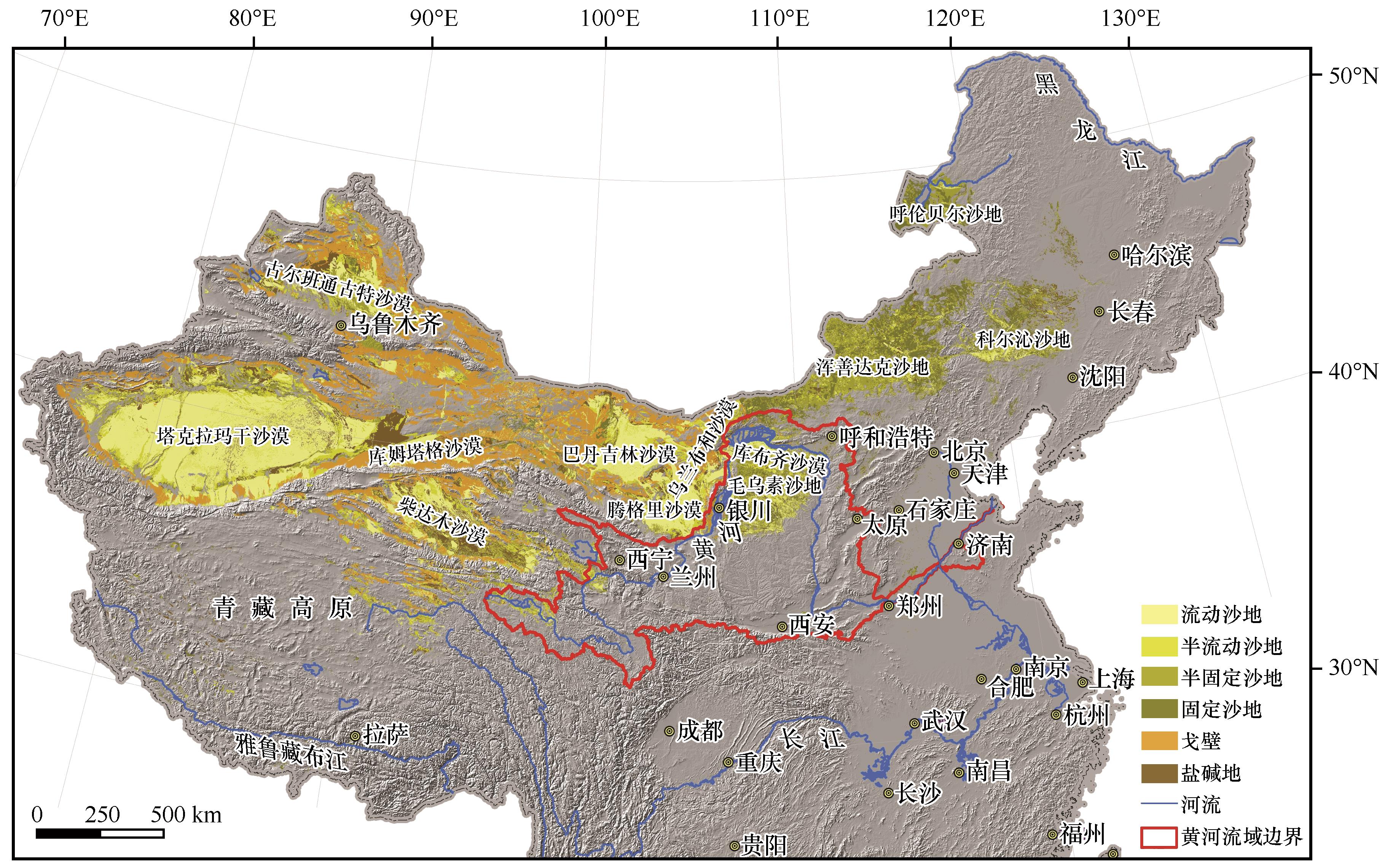
Fig.1 Location map of the Yellow River catchment, main deserts and sandy lands in China
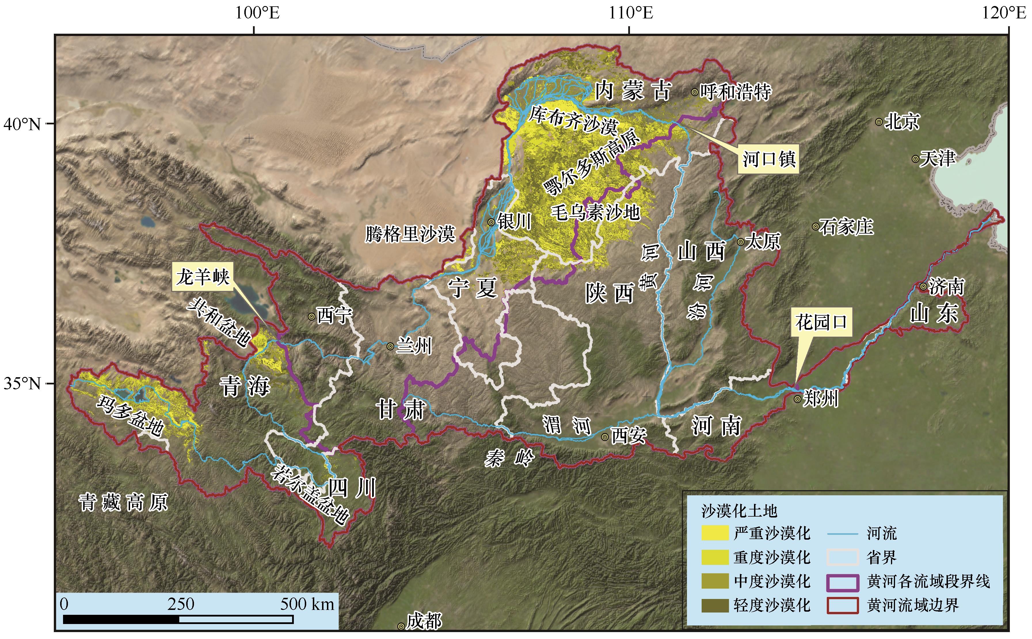
Fig.2 Distribution of aeolian desertification land in the Yellow River catchment

Fig.3 The area of aeolian desertification land in the nine provinces within the Yellow River catchment
| 沙漠化 程度 | 青海 | 四川 | 甘肃 | 宁夏 | 内蒙古 | 陕西 | ||||||
|---|---|---|---|---|---|---|---|---|---|---|---|---|
| 面积/km2 | 比例/% | 面积/km2 | 比例/% | 面积/km2 | 比例/% | 面积/km2 | 比例/% | 面积/km2 | 比例/% | 面积/km2 | 比例/% | |
| 合计 | 17 432 | 100 | 266 | 100 | 474 | 100 | 8 350 | 100 | 91 398 | 100 | 10 730 | 100 |
| 轻度沙漠化 | 2 719 | 16 | 126 | 47 | 146 | 31 | 2 295 | 27 | 22 170 | 24 | 1 777 | 17 |
| 中度沙漠化 | 5 345 | 31 | 79 | 30 | 143 | 30 | 3 258 | 39 | 29 197 | 32 | 3 220 | 30 |
| 重度沙漠化 | 6 180 | 35 | 5 | 2 | 68 | 14 | 1 308 | 16 | 23 378 | 26 | 3 972 | 37 |
| 严重沙漠化 | 3 189 | 18 | 57 | 21 | 116 | 25 | 1 489 | 18 | 16 652 | 18 | 1 762 | 16 |
Table 1 The area of each type of aeolian desertification land and corresponding percentage in the main aeolian desertified provinces within Yellow River catchment
| 沙漠化 程度 | 青海 | 四川 | 甘肃 | 宁夏 | 内蒙古 | 陕西 | ||||||
|---|---|---|---|---|---|---|---|---|---|---|---|---|
| 面积/km2 | 比例/% | 面积/km2 | 比例/% | 面积/km2 | 比例/% | 面积/km2 | 比例/% | 面积/km2 | 比例/% | 面积/km2 | 比例/% | |
| 合计 | 17 432 | 100 | 266 | 100 | 474 | 100 | 8 350 | 100 | 91 398 | 100 | 10 730 | 100 |
| 轻度沙漠化 | 2 719 | 16 | 126 | 47 | 146 | 31 | 2 295 | 27 | 22 170 | 24 | 1 777 | 17 |
| 中度沙漠化 | 5 345 | 31 | 79 | 30 | 143 | 30 | 3 258 | 39 | 29 197 | 32 | 3 220 | 30 |
| 重度沙漠化 | 6 180 | 35 | 5 | 2 | 68 | 14 | 1 308 | 16 | 23 378 | 26 | 3 972 | 37 |
| 严重沙漠化 | 3 189 | 18 | 57 | 21 | 116 | 25 | 1 489 | 18 | 16 652 | 18 | 1 762 | 16 |
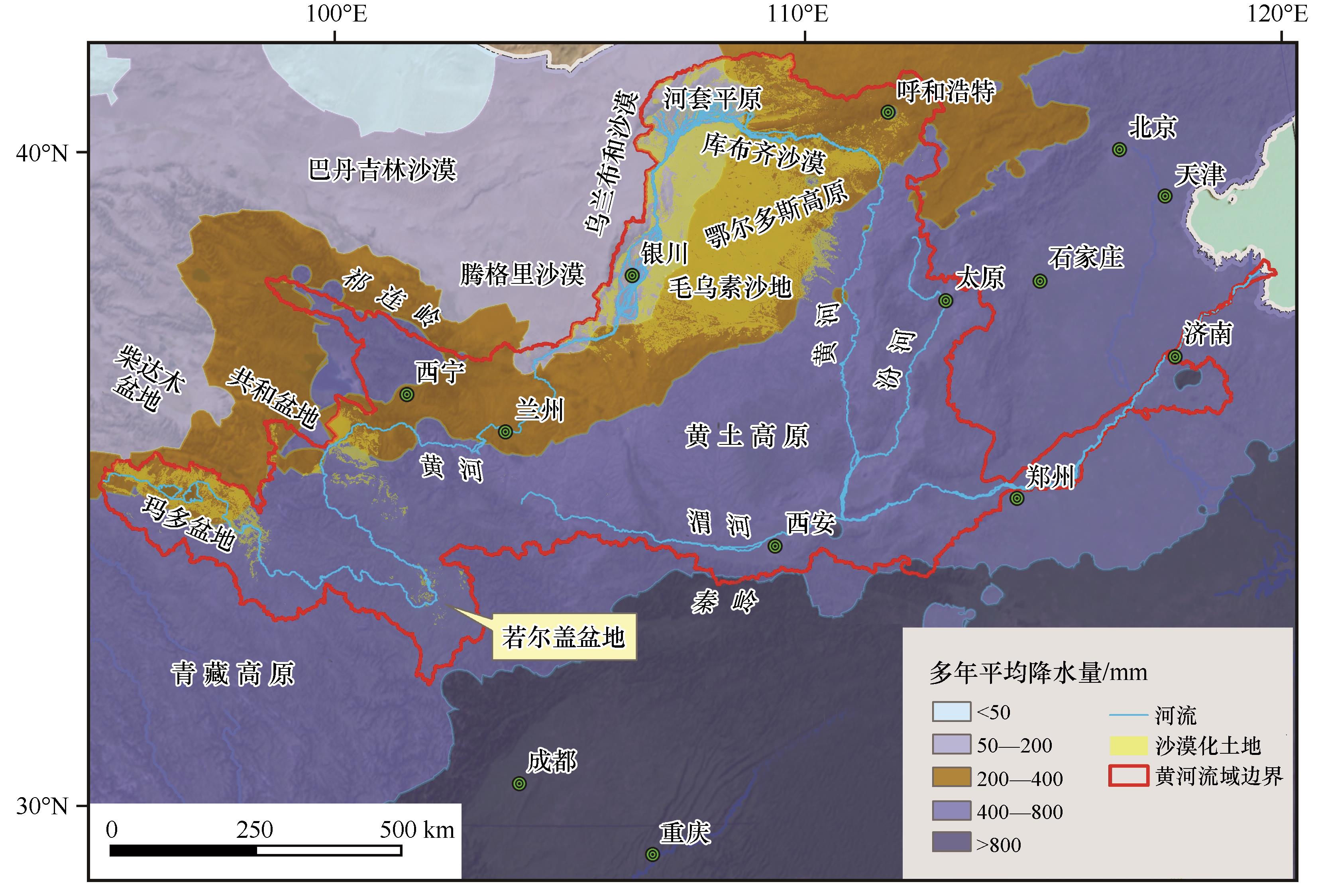
Fig.4 The distribution of aeolian desertification land and mean annual precipitation in the Yellow River catchment
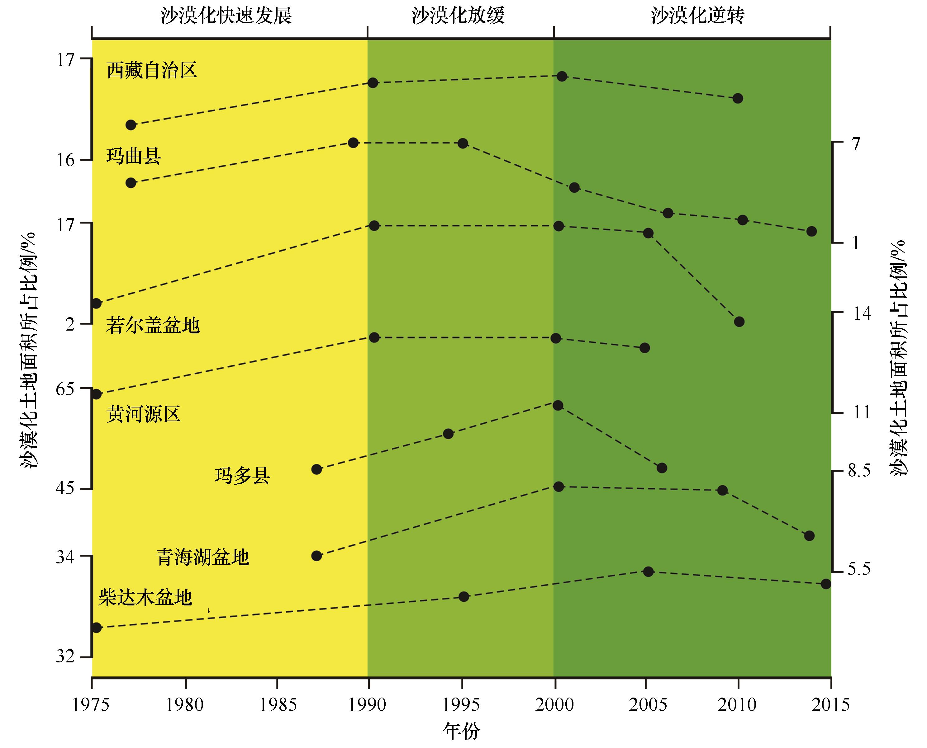
Fig.5 The trend of modern aeolian desertification in Tibetan Plateau and its northeast (modified based on reference [40])
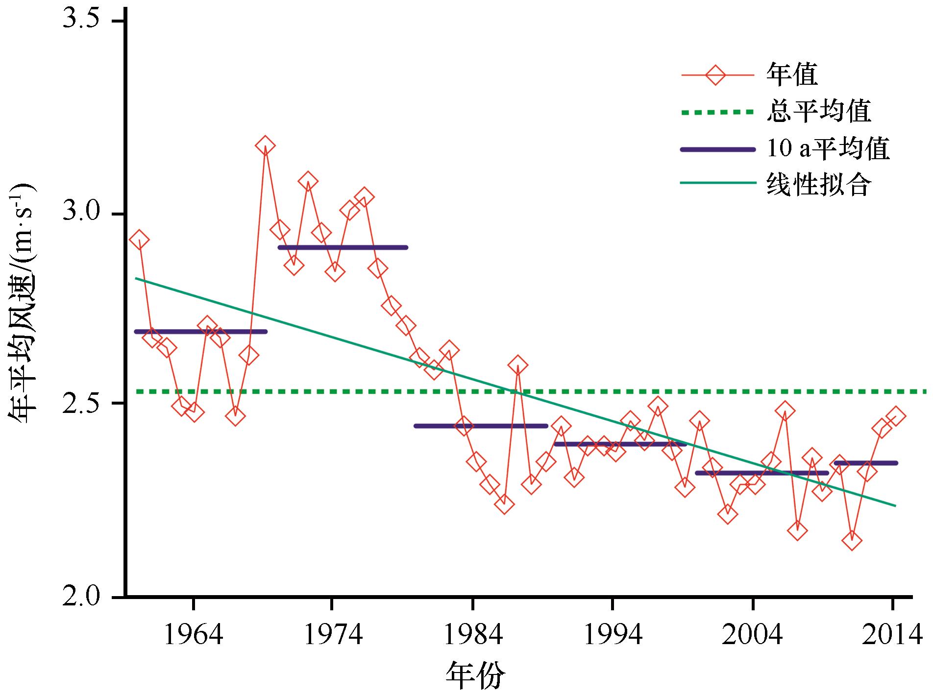
Fig.6 Annual mean wind speed during 1960-2014 in Mu Us Sandy Land (modified based on reference [60])
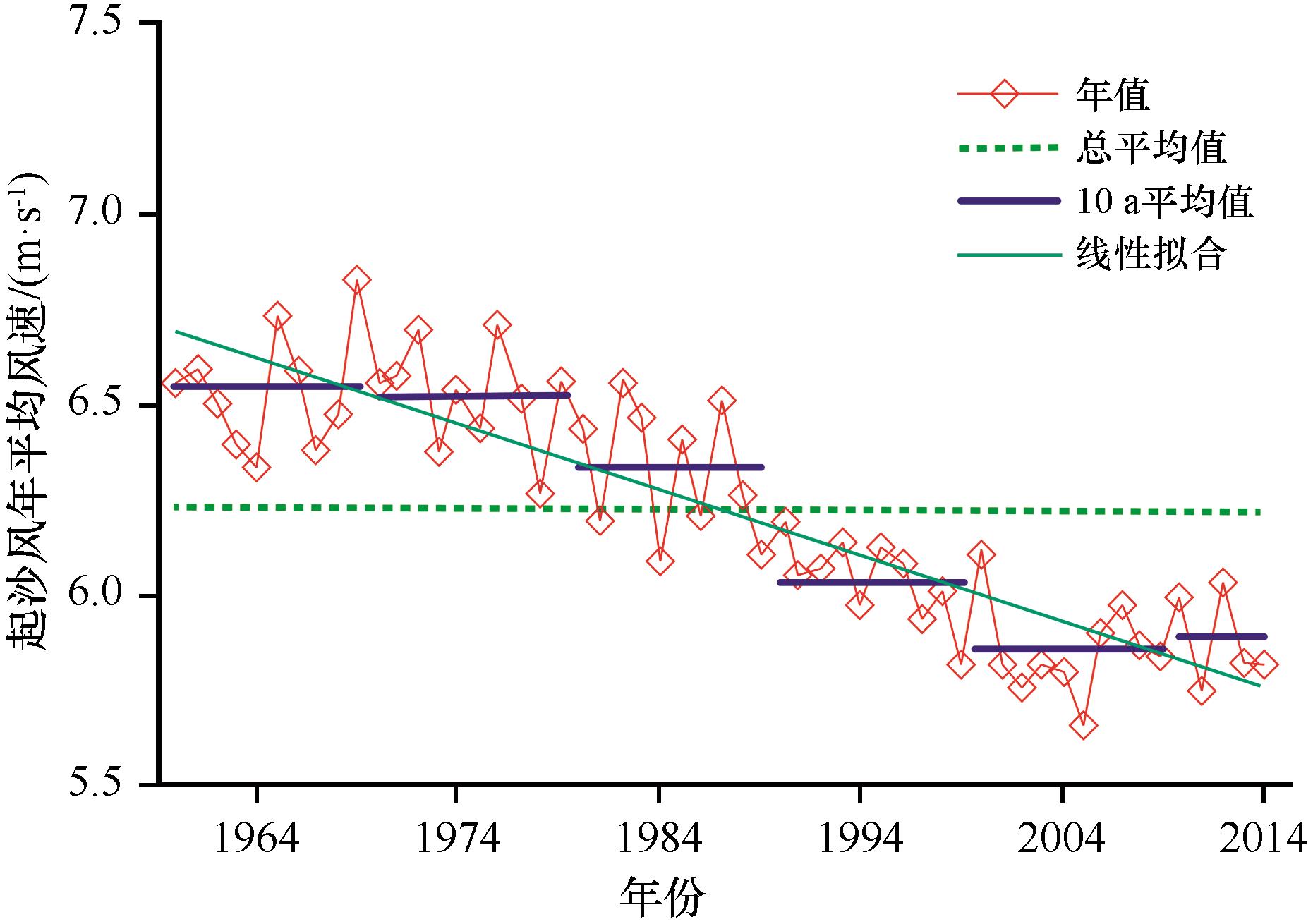
Fig.7 Annual mean sand-driving wind speed during 1960-2014 in Mu Us Sandy Land (modified based on reference [60])
| 1 | Huang J,Yu H,Guan X,et al.Accelerated dryland expansion under climate change[J].Nature Climate Change,2015,6(2):166-171. |
| 2 | Huang J,Zhang G,Zhang Y,et al.Global desertification vulnerability to climate change and human activities[J].Land Degradation & Development,2020,31(11):1380-1391. |
| 3 | 王涛,朱震达.我国沙漠化研究的若干问题:1.沙漠化的概念及其内涵[J].中国沙漠,2003,23(3):1-8. |
| 4 | 何智娟,黄锦辉,潘轶敏,等.黄河流域生态系统特征及下游生态修复实践[J].环境与可持续发展,2010,35(4):9-13. |
| 5 | 顾延生.黄河源头鄂陵湖出水口首次断流警示[J].柴达木开发研究,2004(6):29-30. |
| 6 | 董光荣,靳鹤龄,陈惠忠,等.中国北方半干旱和半湿润地区沙漠化的成因[J].第四纪研究,1998,18(2):136-144. |
| 7 | 徐志伟,鹿化煜.毛乌素沙地风沙环境变化研究的理论和新认识[J].地理学报,2021,76(1):1-23. |
| 8 | 张爽,徐海,蓝江湖,等.中国北方近500年沙尘暴活动及机制[J].中国科学:地球科学,2021,51(5):783-794. |
| 9 | Chen F,Chen S,Zhang X,et al.Asian dust-storm activity dominated by Chinese dynasty changes since 2000 BP[J].Nature Communications,2020,11(1):992. |
| 10 | Bryan B A,Gao L,Ye Y,et al.China’s response to a national land-system sustainability emergency[J].Nature,2018,559(7713):193-204. |
| 11 | 郭晓佳,周荣,李京忠,等.黄河流域农业资源环境效率时空演化特征及影响因素[J].生态与农村环境学报,2021,37(3):332-340. |
| 12 | 颜长珍,王建华.中国1∶10万沙漠(沙地)分布数据集[DS].兰州:国家冰川冻土沙漠科学数据中心(www.ncdc.ac.cn),2019. |
| 13 | 董治宝,胡光印,颜长珍,等.江河源区沙漠化[M].北京:科学出版社,2013. |
| 14 | 王涛,吴薇,王熙章.沙质荒漠化的遥感监测与评估:以中国北方沙质荒漠化区内的实践为例[J].第四纪研究,1998,18(2):108-118. |
| 15 | 朱震达,吴正,刘恕.中国沙漠概论[M].北京:科学出版社,1980. |
| 16 | 王涛.中国沙漠与沙漠化[M].石家庄:河北科学技术出版社,2003. |
| 17 | 徐新良,张亚庆.中国气象背景数据集[DS].北京:中国科学院资源环境科学数据中心数据注册与出版系统(http://www.resdc.cn/DOI),2017. |
| 18 | 竺可桢.东南季风与中国之雨量[J].地理学报,1934(1):1-27. |
| 19 | Nie J,Stevens T,Rittner M,et al.Loess Plateau storage of Northeastern Tibetan Plateau-derived Yellow River sediment[J].Nature Communications,2015,6:8511. |
| 20 | Li B,Sun D,Xu W,et al.Paleomagnetic chronology and paleoenvironmental records from drill cores from the Hetao Basin and their implications for the formation of the Hobq Desert and the Yellow River[J].Quaternary Science Reviews,2017,156:69-89. |
| 21 | Du J,Wang X.Optically stimulated luminescence dating of sand-dune formed within the Little Ice Age[J].Journal of Asian Earth Sciences,2014,91:154-162. |
| 22 | 申震洲,姚文艺,肖培青,等.黄河流域砒砂岩区地貌-植被-侵蚀耦合研究进展[J].水利水运工程学报,2020(4):64-71. |
| 23 | 董光荣,高尚玉,金炯.青海共和盆地土地沙漠化与防治途径[M].北京:科学出版社,1993. |
| 24 | 张胜邦,董旭.青海格尔木市防治荒漠化规划研究[M].北京:中国环境科学出版社,1997. |
| 25 | 金炯,董光荣,邵立业.阿里地区狮泉河镇风沙危害与整治规划[J].中国沙漠,1991,11(3):23-31. |
| 26 | 董光荣,金炯,邵立业.西藏自治区”一江两河“流域土地沙漠化状况[J].中国沙漠,1991,11(1):62-64. |
| 27 | 张伟民,董光荣,屈建军.西藏“一江两河”中部流域地区沙漠化土地基本状况[J].中国沙漠,1993,13(4):56-60. |
| 28 | 董光荣,董玉祥,金炯,等.西藏“一江两河”中部流域地区土地沙漠化的成因与发展趋势[J].中国沙漠,1994,14(2):9-17. |
| 29 | 李森,董光荣,董玉祥,等.西藏“一江两河”中部流域地区土地沙漠化防治目标、对策与治沙工程布局[J].中国沙漠,1994,14(2):55-63. |
| 30 | Li Q,Zhang C,Shen Y,et al.Quantitative assessment of the relative roles of climate change and human activities in desertification processes on the Qinghai-Tibet Plateau based on net primary productivity[J].Catena,2016,147:789-796. |
| 31 | Dong Z,Hu G,Qian G,et al.High-altitude aeolian research on the Tibetan Plateau[J].Reviews of Geophysics,2017,55(4):864-901. |
| 32 | Zhang C,Li Q,Shen Y,et al.Monitoring of aeolian desertification on the Qinghai-Tibet Plateau from the 1970s to 2015 using Landsat images[J].Science of The Total Environment,2018,619-620:1648-1659. |
| 33 | Hu G,Jin H,Dong Z,et al.Driving forces of aeolian desertification in the source region of the Yellow River:1975-2005[J].Environmental Earth Sciences,2013,70(7):3245-3254. |
| 34 | Xue X,Guo J,Han B,et al.The effect of climate warming and permafrost thaw on desertification in the Qinghai-Tibetan Plateau[J].Geomorphology,2009,108(3/4):182-190. |
| 35 | Hu G,Dong Z,Lu J,et al.The developmental trend and influencing factors of aeolian desertification in the Zoige Basin,eastern Qinghai-Tibet Plateau[J].Aeolian Research,2015,19:275-281. |
| 36 | 胡梦珺,潘宁惠,左海玲,等.基于RS和GIS的玛曲高原土地沙漠化时空演变研究[J].生态学报,2017,37(3):922-931. |
| 37 | 李森,颜长珍,宋翔,等.近30a龙羊峡水库周边地区沙漠化遥感监测[J].中国沙漠,2011,31(4):836-841. |
| 38 | 李晓英,姚正毅,董治宝.青海省共和盆地沙漠化驱动机制[J].水土保持通报,2018,38(6):337-344. |
| 39 | 胡梦珺,李向锋,左海玲,等.1989—2014年共和盆地贵南县土地沙漠化动态[J].中国沙漠,2018,38(1):30-38. |
| 40 | Li J,Yao Q,Zhou N,et al.Modern aeolian desertification on the Tibetan Plateau under climate change[J].Land Degradation & Development,2020,32(3):3862. |
| 41 | Li Q,Zhang C,Shen Y,et al.Developing trend of aeolian desertification in China’s Tibet Autonomous Region from 1977 to 2010[J].Environmental Earth Sciences,2016,75(10):1-12. |
| 42 | 李庆.青藏高原土地沙漠化及驱动力研究[D].北京:北京师范大学,2016. |
| 43 | Wang H,Ma M,Geng L.Monitoring the recent trend of aeolian desertification using Landsat TM and Landsat 8 imagery on the north-east Qinghai-Tibet Plateau in the Qinghai Lake basin[J].Natural Hazards,2015,79(3):1753-1772. |
| 44 | 王睿,杨国靖.库布齐沙漠生态治理的生态经济系统耦合分析[J].干旱区地理,2020,43(5):1391-1400. |
| 45 | 刘庆福.毛乌素沙地沙漠化演变、飞播恢复评估及其对生态系统服务的影响[D].呼和浩特:内蒙古大学,2020. |
| 46 | 孙继敏,丁仲礼,袁宝印,2000a B.P.来毛乌素地区的沙漠化问题[J].干旱区地理,1995,18(1):36-42. |
| 47 | 黄银洲.鄂尔多斯高原近2000年沙漠化过程与成因研究[D].兰州:兰州大学,2009. |
| 48 | Huang Y,Wang N,He T,et al.Historical desertification of the Mu Us Desert,Northern China:a multidisciplinary study[J].Geomorphology,2009,110(3/4):108-117. |
| 49 | Wen P,Wang N,Wang Y,et al.Fluvial incision caused irreversible environmental degradation of an ancient city in the Mu Us Desert,China[J].Quaternary Research,2020,99:1-13. |
| 50 | 冯坤,颜长珍,谢家丽,等.1975—2015年鄂尔多斯市沙漠化的时空演变过程[J].中国沙漠,2018,38(2):233-242. |
| 51 | 白壮壮,崔建新,丁晓辉.1986—2015年鄂尔多斯高原沙漠化及其驱动因素研究[J].干旱区研究,2020,37(3):749-756. |
| 52 | 王涛.中国北方沙漠与沙漠化图集[M].北京:科学出版社,2014. |
| 53 | 胡光印,董治宝,魏振海,等.近30a来若尔盖盆地沙漠化时空演变过程及成因分析[J].地球科学进展,2009,24(8):908-916. |
| 54 | 王涛.我国沙漠化研究的若干问题:2.沙漠化的研究内容[J].中国沙漠,2003,23(5):1-6. |
| 55 | 吴正.浅议我国北方地区的沙漠化问题[J].地理学报,1991,46(3):266-276. |
| 56 | 徐丽娇,胡泽勇,赵亚楠,等.1961—2010年青藏高原气候变化特征分析[J].高原气象,2019,38(5):911-919. |
| 57 | 侯冰飞.黄河源区气候变化与径流补给的关联性分析[D].北京:北京林业大学,2020. |
| 58 | Zeng Z,Ziegler A D,Searchinger T,et al.A reversal in global terrestrial stilling and its implications for wind energy production[J].Nature Climate Change,2019,9(12):979-985. |
| 59 | Chen L,Li D,Pryor S C.Wind speed trends over China:quantifying the magnitude and assessing causality[J].International Journal of Climatology,2013,33(11):2579-2590. |
| 60 | 李晓岚.毛乌素沙地沙漠化逆转过程及成因分析[D].西安:陕西师范大学,2017. |
| 61 | Mcvicar T R,Roderick M L,Donohue R J,et al.Global review and synthesis of trends in observed terrestrial near-surface wind speeds:implications for evaporation[J].Journal of Hydrology,2012,416:182-205. |
| 62 | Yang H,Yang D.Climatic factors influencing changing pan evaporation across China from 1961 to 2001[J].Journal of Hydrology,2012,414:184-193. |
| 63 | Vitousek P M,Mooney H A,Lubchenco J,et al.Human domination of earth's ecosystems[J].Science,1997,277(5325):494. |
| 64 | 宋永永,薛东前,夏四友,等.近40a黄河流域国土空间格局变化特征与形成机理[J].地理研究,2021,40(5):1445-1463. |
| 65 | 董立新,王文科,孔金玲,等.黄河上游玛多县生态环境变化遥感监测及成因分析[J].水土保持通报,2005,25(4):68-72. |
| 66 | Dong Z,Hu G,Yan C,et al.Aeolian desertification and its causes in the Zoige Plateau of China’s Qinghai-Tibetan Plateau[J].Environmental Earth Sciences,2010,59(8):1731-1740. |
| 67 | 郭连云,丁生祥,汪青春.气候变化与人类活动对共和盆地生态环境的影响[J].干旱地区农业研究,2009,27(1):219-226. |
| [1] | Man Sun, Tao Song. Spatio-temporal patterns and coordinated development of technological innovation and industrial development in the Yellow River Basin of Gansu Province, China [J]. Journal of Desert Research, 2021, 41(4): 140-151. |
| [2] | Mengtao Han, Jianjun Tu, Guiping Xu, Li Jiang. Spatio-temporal coordination between aquatic ecosystem services and economic development in the Yellow River Basin [J]. Journal of Desert Research, 2021, 41(4): 167-176. |
| [3] | Guangqin Li, Xubing Fang. Spatio-temporal evolution characteristics of green development level in the Yellow River Basin [J]. Journal of Desert Research, 2021, 41(4): 129-139. |
| [4] | Gaopeng Sun, Xianfeng Liu, Xiaohong Wang, Shuangshuang Li. Changes in vegetation coverage and its influencing factors across the Yellow River Basin during 2001-2020 [J]. Journal of Desert Research, 2021, 41(4): 205-212. |
| [5] | Cheng Zhou, Xuhong Zhang, Qian Zhang, Binghua Liu. The construction of "Five in One" comprehensive evaluation system and spatial difference in the Yellow River Basin [J]. Journal of Desert Research, 2021, 41(4): 1-11. |
| [6] | Jie Yang, Baopeng Xie, Degang Zhang. Spatial-temporal evolution of habitat quality and its influencing factors in the Yellow River Basin based on InVEST model and GeoDetector [J]. Journal of Desert Research, 2021, 41(4): 12-22. |
| [7] | Junhao Li, Yong Chen, Guojing Yang, Lihua Zhou. The aeolian desertification process and driving mechanism of Minqin Oasis from 1975 to 2018 [J]. Journal of Desert Research, 2021, 41(3): 44-55. |
| [8] | Zheting Jia, Jiuyan Yang, Yanxia Sun, Qi Chen, Ruiling Yan. Spatial distribution pattern of Salsola passerina population in Alashan Plateau [J]. Journal of Desert Research, 2021, 41(1): 119-128. |
| [9] | Yuanyuan Zhao, Haiyan Wu, Guodong Ding, Guanglei Gao, Wenzhu Tu. A review on the aeolian desertification in the Otindag Sandy Land [J]. Journal of Desert Research, 2020, 40(5): 101-111. |
| [10] | Guangyin Hu, Zhibao Dong, Zhengcai Zhang, Ming Zhou, Lunyu Shang. The regime of sand driving wind and sand drift potential in Zoige Basin [J]. Journal of Desert Research, 2020, 40(5): 20-24. |
| [11] | Wang Lixiang, Cai Mingyu, Bai Xuelian, Qiao Rongrong, Ji Shuxin, Chang Xueli. Lake fluctuation and driving factors in the Wulanbuhe Desert of China [J]. Journal of Desert Research, 2020, 40(2): 59-67. |
| [12] | Sun Yanxia, Yang Jiuyan, Qiao Yiqing, Guo Chaoli, Shao Yiming, Wang Jianyu. Spatial distribution pattern of Reaumuria songarica population in Alashan Plateau [J]. Journal of Desert Research, 2020, 40(1): 105-115. |
| [13] | Tian Guiquan, Han Shumei, Suriguga. Distribution Patterns of Ground Bryophytes in the Daqinggou National Nature Reserve, Inner Mongolia, China [J]. Journal of Desert Research, 2018, 38(3): 545-552. |
| [14] | Feng Kun, Yan Changzhen, Xie Jiali, Qian Dawen. Spatial-temporal Evolution of Aeolian Desertification Process in Ordos City during 1975-2015 [J]. JOURNAL OF DESERT RESEARCH, 2018, 38(2): 233-242. |
| [15] | Zhou Yingying, Chen Yaning, Zhu Chenggang, Chen Yapeng, Chen Xiaolin. Population Structure Characteristics of Population euphratica in the Lower Reaches of Tarim River [J]. Journal of Desert Research, 2018, 38(2): 315-323. |
| Viewed | ||||||
|
Full text |
|
|||||
|
Abstract |
|
|||||
©2018Journal of Desert Research
Tel:0931-8267545
Email:caiedit@lzb.ac.cn;desert@lzb.ac.cn
Support:Magtech