
- CN 62-1070/P
- ISSN 1000-694X
- Bimonthly 1981
Journal of Desert Research ›› 2022, Vol. 42 ›› Issue (3): 187-195.DOI: 10.7522/j.issn.1000-694X.2021.00149
Yiran Zhang1( ), Tingxi Liu1,2(), Xin Tong1,2, Limin Duan1,2, Tianyu Jia1, Yaxin Ji1
Received:2021-09-06
Revised:2021-12-13
Online:2022-05-20
Published:2022-06-01
Contact:
Tingxi Liu
CLC Number:
Yiran Zhang, Tingxi Liu, Xin Tong, Limin Duan, Tianyu Jia, Yaxin Ji. Inversion of vegetation coverage based on multi-source remote sensing data and machine learning method in the Horqin Sandy Land, China[J]. Journal of Desert Research, 2022, 42(3): 187-195.
Add to citation manager EndNote|Ris|BibTeX
URL: http://www.desert.ac.cn/EN/10.7522/j.issn.1000-694X.2021.00149
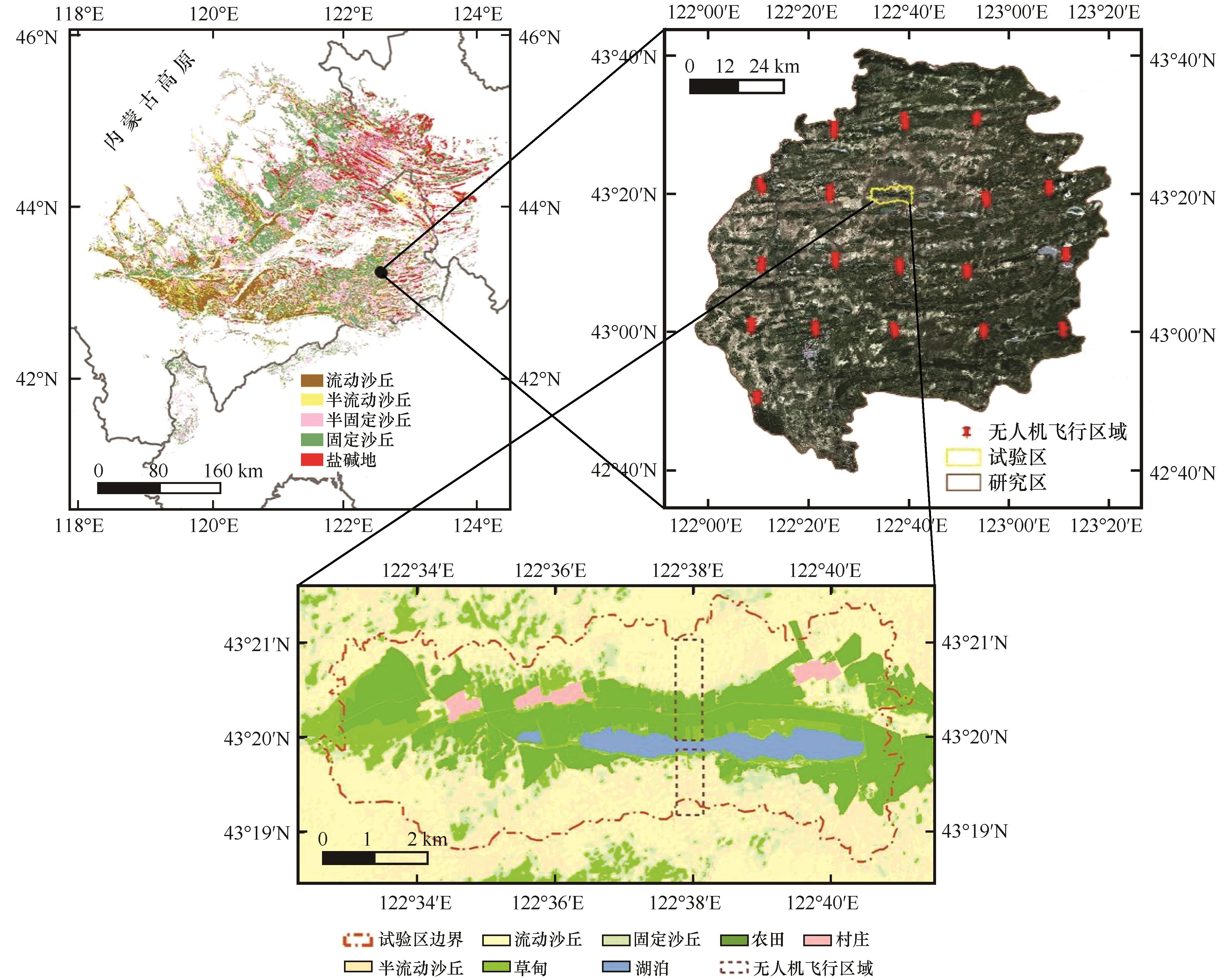
Fig.1 Location of research area, test area and UAV aerial photography area
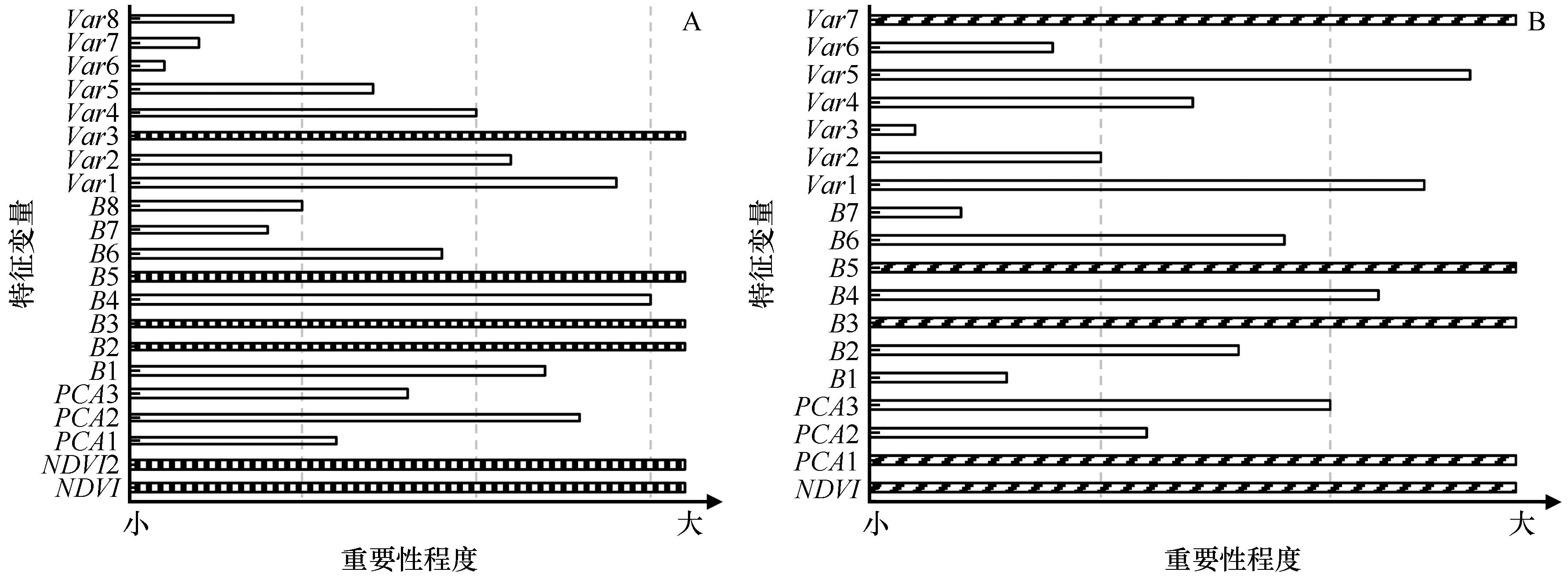
Fig.2 Variables selection for Worldview-2 (A) and Landsat 8 OLI (B)
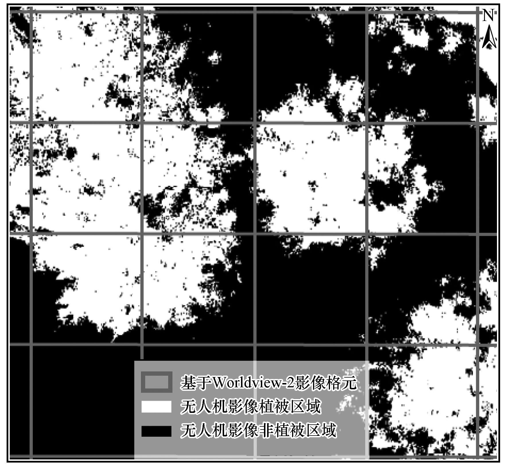
Fig.3 Using Worldview-2 remote sensing image grid as statistical unit to calculate vegetation coverage
| 方法 | 训练集 | 测试集 | ||||
|---|---|---|---|---|---|---|
| 决定系数R2 | 均方差MSE | 一致性指数d | 决定系数R2 | 均方差MSE | 一致性指数d | |
| BP-ANN | 0.76 | 0.0816 | 0.9302 | 0.73 | 0.0886 | 0.9217 |
| SVR | 0.81 | 0.0706 | 0.945 | 0.80 | 0.0831 | 0.9401 |
| RF | 0.94 | 0.0054 | 0.9838 | 0.84 | 0.0145 | 0.9576 |
Table 1 Accuracy evaluation of different models in unit scale (the test area)
| 方法 | 训练集 | 测试集 | ||||
|---|---|---|---|---|---|---|
| 决定系数R2 | 均方差MSE | 一致性指数d | 决定系数R2 | 均方差MSE | 一致性指数d | |
| BP-ANN | 0.76 | 0.0816 | 0.9302 | 0.73 | 0.0886 | 0.9217 |
| SVR | 0.81 | 0.0706 | 0.945 | 0.80 | 0.0831 | 0.9401 |
| RF | 0.94 | 0.0054 | 0.9838 | 0.84 | 0.0145 | 0.9576 |
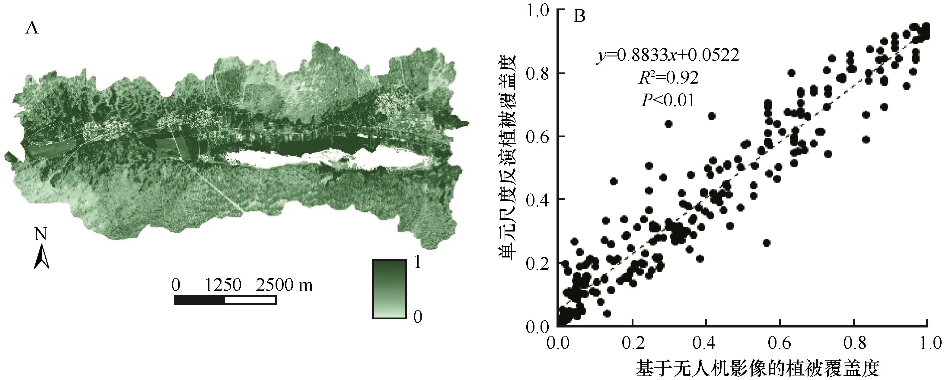
Fig.4 Vegetation coverage (A) and accuracy verification (B) of Worldview-2 remote sensing image inversion in the test area
| 方法 | 训练集 | 测试集 | ||||
|---|---|---|---|---|---|---|
| R2 | MSE | d | R2 | MSE | d | |
| BP-ANN | 0.52 | 0.1599 | 0.8113 | 0.49 | 0.1959 | 0.7869 |
| SVR | 0.68 | 0.1447 | 0.8322 | 0.61 | 0.1503 | 0.8121 |
| RF | 0.87 | 0.0082 | 0.9595 | 0.80 | 0.0370 | 0.8991 |
Table 2 Accuracy evaluation of different models in regional scale (the research area)
| 方法 | 训练集 | 测试集 | ||||
|---|---|---|---|---|---|---|
| R2 | MSE | d | R2 | MSE | d | |
| BP-ANN | 0.52 | 0.1599 | 0.8113 | 0.49 | 0.1959 | 0.7869 |
| SVR | 0.68 | 0.1447 | 0.8322 | 0.61 | 0.1503 | 0.8121 |
| RF | 0.87 | 0.0082 | 0.9595 | 0.80 | 0.0370 | 0.8991 |
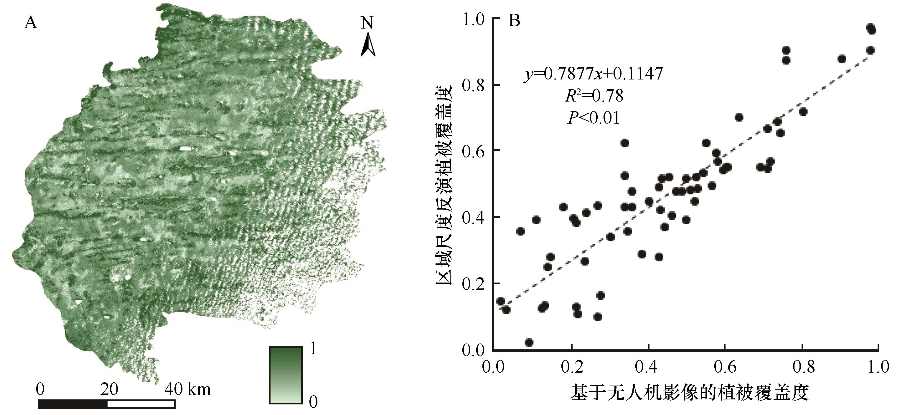
Fig.5 Study area vegetation coverage (A) and accuracy verification (B) of Landsat 8 OLI remote sensing image inversion
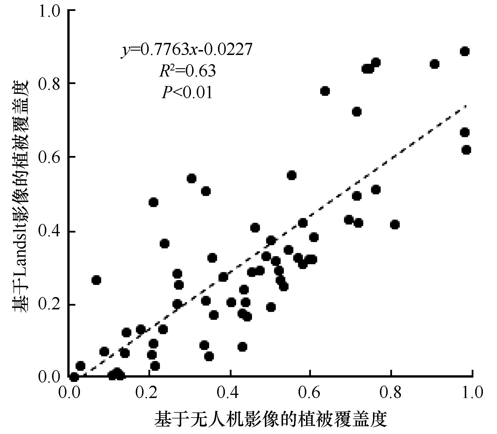
Fig.6 Accuracy verification of vegetation coverage inversion using a single remote sensing image (Landsat 8 OLI)
| 1 | Feng L L, Jia Z Q, Li Q X,et al.Spatiotemporal change of sparse vegetation coverage in Northern China[J].Journal of the Indian Society of Remote Sensing,2019,47(2):18-26. |
| 2 | Feng H, Zou B, Luo J.Coverage-dependent amplifiers of vegetation change on global water cycle dynamics[J].Journal of Hydrology,2017,550:220-229. |
| 3 | Gao J, Liu Y S.Determination of land degradation causes in Tongyu County,Northeast China via land cover change detection[J].International Journal of Applied Earth Observation and Geoinformation,2009,12(1):9-16. |
| 4 | 宋超,余琦殷,王瑞霞,等.基于植被覆盖度的宁夏灵武白芨滩自然保护区防风固沙功能时空变化研究[J].生态学报,2021,41(8):1-13. |
| 5 | Zhou Q, Wei X, Zhou X,et al.Vegetation coverage change and its response to topography in a typical karst region:the Lianjiang River Basin in Southwest China[J].Environmental Geology,2019,78(6):191-201. |
| 6 | 万红梅,李霞,董道瑞.基于多源遥感数据的荒漠植被覆盖度估测[J].应用生态学报,2012,23(12):3331-3337. |
| 7 | Curran P J, Williamson H D.Sample size for ground and remotely sensed data[J].Remote Sensing of Environment,1986,20(1):31-41. |
| 8 | Meng B P, Gao J L, Liang T G,et al.Modeling of alpine grassland cover based on unmanned aerial vehicle technology and multi-factor methods:a case study in the East of Tibetan Plateau,China[J].Remote Sensing,2018,10(2):320-339. |
| 9 | 刘婵,赵文智,刘冰,等.基于无人机和MODIS数据的巴丹吉林沙漠植被分布特征与动态变化研究[J].中国沙漠,2019,39(4):92-102. |
| 10 | 蔡宗磊,苗正红,常雪,等.基于无人机大样方数据及国产卫星反演草地植被覆盖度方法研究[J].草地学报,2019,27(5):1431-1440. |
| 11 | 贾坤,姚云军,魏香琴,等.植被覆盖度遥感估算研究进展[J].地球科学进展,2013,28(7):774-782. |
| 12 | Jia K, Liang S L, Gu X F,et al.Fractional vegetation cover estimation algorithm for Chinese GF-1 wide field view data[J].Remote Sensing of Environment,2016,177:184-191. |
| 13 | 陈黔,李晓松,修晓敏,等.基于Google Earth Engine与机器学习的大尺度30 m分辨率沙地灌木覆盖度估算[J].生态学报,2019,39(11):4056-4069. |
| 14 | Higginbottom T P, Symeonakis E, Meyer H,et al.Mapping fractional woody cover in semi-arid savannahs using multi-seasonal composites from Landsat data[J].ISPRS Journal of Photogrammetry and Remote Sensing,2018,139:88-102. |
| 15 | Ge J, Meng B P, Liang T G,et al.Modeling alpine grassland cover based on MODIS data and support vector machine regression in the headwater region of the Huanghe River,China[J].Remote Sensing of Environment,2018,218(9):162-173. |
| 16 | 刘垚燚,曾鹏,张然,等.基于GEE和BRT的1984-2019年长三角生态绿色一体化发展示范区植被覆盖度变化[J].应用生态学报,2021,32(3):1033-1044. |
| 17 | 张亦然,刘廷玺,童新,等.基于U型神经网络的沙丘-草甸相间地区无人机影像植被覆盖度提取及其影响因素[J].中国沙漠,2021,41(3):16-24. |
| 18 | Zuo X A, Zhao X Y, Zhao H L,et al.Scale dependent effects of environmental factors on vegetation pattern and composition in Horqin Sandy Land,Northern China[J].Geoderma,2012,174(8):1-9. |
| 19 | 汪小钦,王苗苗,王绍强,等.基于可见光波段无人机遥感的植被信息提取[J].农业工程学报,2015,31(5):152-158. |
| 20 | 张泽民,吕昌河,谢苗苗,等.基于WorldView-2影像的矿区植被重建效果评估[J].生态学报,2018,38(4):1301-1310. |
| 21 | 赵英时.遥感应用分析原理与方法[M].北京:科学出版社,2003:28-35. |
| 22 | 朱婉雪,孙志刚,李彬彬,等.基于无人机遥感的滨海盐碱地土壤空间异质性分析与作物光谱指数响应胁迫诊断[J].地球信息科学学报,2021,23(3):536-549. |
| 23 | Rumelhart D E, Hinton G E, Williams R J.Learning representations by back-propagating errors[J].Nature,1986,323(6088):533-536. |
| 24 | Cortes C, Vapnik V.Support-vector networks[J].Machine Learning,1995,20(3):273-297. |
| 25 | Breiman L.Random Forests[J].Machine Learning,2001,45(1):5-32. |
| 26 | Li M Y, Liu T X, Luo Y Y,et al.Fractional vegetation coverage downscaling inversion method based on land remote-sensing satellite (System,Landsat-8) and polarization decomposition of Radarsat-2[J].International Journal of Remote Sensing,2021,42(9):3255-3276. |
| 27 | 王惠宁,靳瑰丽,范燕敏,等.不同盖度下伊犁绢蒿荒漠草地光谱特征及盖度反演精度研究[J].中国草地学报,2019,41(2):51-57. |
| 28 | Wang C, Du H Q, Xu X J,et al.Multi-scale crown closure retrieval for moso bamboo forest using multi-source remotely sensed imagery based on geometric-optical and Erf-BP neural network models[J].International Journal of Remote Sensing,2015,36(21):5384-5402. |
| 29 | Wang H, Mu Y, Jiang L.Landscape-level vegetation classification and fractional woody and herbaceous vegetation cover estimation over the dryland ecosystems by unmanned aerial vehicle platform[J].Agricultural and Forest Meteorology,2019,278:107-128. |
| 30 | Leprieur C, Kerr Y H, Mastorchio S,et al.Monitoring vegetation cover across semi-arid regions:comparison of remote observations from various scales[J].International Journal of Remote Sensing,2000,21(2):281-300. |
| 31 | 古丽·加帕尔,陈曦,包安明.干旱区荒漠稀疏植被覆盖度提取及尺度扩展效应[J].应用生态学报,2009,20(12):2925-2934. |
| 32 | Tang L, He M, Li X.Verification of fractional vegetation coverage and NDVI of desert vegetation via UAVRS technology[J].Remote Sensing,2020,12(11):1742-1754. |
| 33 | 王光镇,王静璞,邹学勇,等.基于像元三分模型的锡林郭勒草原光合植被和非光合植被覆盖度估算[J].生态学报,2017,37(17):5722-5731. |
| 34 | Zhang W, Yang X, Manlike A,et al.Comparative study of remote sensing estimation methods for grassland fractional vegetation coverage:a grassland case study performed in Hi prefecture,Xinjiang,China[J].International Journal of Remote Sensing,2019,40(6):2243-2258. |
| 35 | 张文强,孙从建,李新功.晋西南黄土高原区植被覆盖度变化及其生态效应评估[J].自然资源学报,2019,34(8):1748-1758. |
| [1] | Xiaolong Zhao, Yuhong Xie, Xujun Ma, Shaokun Wang. Vegetation structure and its relationship with soil physicochemical properties in restoring sandy grassland in Horqin Sandy Land [J]. Journal of Desert Research, 2022, 42(2): 134-141. |
| [2] | Jin Zhan, Dan Han, Hongling Yang, Yulin Li. Evolution characteristics of vegetation community composition and diversity during the restoration of Horqin Sandy Land in 2005-2019 [J]. Journal of Desert Research, 2022, 42(2): 194-206. |
| [3] | Lichao Zhuang, Naiang Wang, Xunhe Zhang, Liqiang Zhao, Xianbao Su. Analysis on the difference of the spatial model of lake ice freezing and melting in the Badain Jaran Desert [J]. Journal of Desert Research, 2021, 41(3): 214-223. |
| [4] | Dan Han, Yulin Li, Jin Zhan, Hongling Yang. Emergy-based comparison on sustainable development of villages with different farming and pastoral ratios in Horqin Sandy Land [J]. Journal of Desert Research, 2021, 41(3): 235-244. |
| [5] | Yinping Chen, Wenjie Cao, Peidong Yu, Huan Yang, Xuyang Wang, Yuqiang Li. The effects of soil water content on sand flow structure and wind erosion amount with wind tunnel experiment in semi-arid area [J]. Journal of Desert Research, 2021, 41(2): 173-180. |
| [6] | Yimei Sun, Qing Tian, Aixia Guo, Xiaoan Zuo, Peng Lv, Senxi Zhang. Effects of water and nitrogen changes on vegetation characteristics and leaf traits in Horqin Sandy land, Northern China [J]. Journal of Desert Research, 2020, 40(6): 223-232. |
| [7] | Jin Zhan, Yulin Li, Dan Han, Hongling Yang. Biomass allocation and its ecological significance of three dominant sand-fixing shrubs in the semi-arid desert area [J]. Journal of Desert Research, 2020, 40(5): 149-157. |
| [8] | Huang Tianyu, Liu Tingxi, Duan Limin, Li Dongfang, Wang Guanli, Chen Xiaoping. Characteristics of Water and Heat Fluxes and Its Footprint Climatology in Horqin Cascade Ecological Zone [J]. Journal of Desert Research, 2019, 39(6): 30-39. |
| [9] | Yang Hongling, Li Yulin, Ning Zhiying, Zhang Ziqian. Home-field Effects of Leaf Litter Decomposition of Dominate Sand-fixing Shrubs in the Horqin Sandy Land [J]. Journal of Desert Research, 2019, 39(5): 62-70. |
| [10] | Chelmeg, Liu Xinping, He Yuhui, Wang Mingming, Wei Shuilian, Li Yulin, Sun Shanshan. Characteristics on Direct Foliar Rainwater Absorption of Several Common Plants in Horqin Sandy Land [J]. Journal of Desert Research, 2018, 38(5): 1017-1023. |
| [11] | Qu Hao, Zhao Halin, Shi Yongqiang, Gao Baolan, Li Ying, Ji Mingfei, Wurengaowa, Li Ying. Effects of Sand Burial on Survival and Photosynthesis Characteristics of Two Main Crops in Horqin Sandy Land [J]. JOURNAL OF DESERT RESEARCH, 2017, 37(4): 698-704. |
| [12] | Zhang Jing, Zuo Xiaoan, Lv Peng, Zhou Xin, Lian Jie, Liu Liangxu, Yue Xiyuan. Response of Grassland Vegetation in Horqin Sandy Land to Exclosure and Grazing [J]. JOURNAL OF DESERT RESEARCH, 2017, 37(3): 446-452. |
| [13] | Zhang Jianpeng, Li Yuqiang, Zhao Xueyong, Zhang Tonghui, She Qiannan, Liu Min, Wei Shuilian. Effects of Exclosure on Soil Physicochemical Properties and Carbon Sequestration Potential Recovery of Desertified Grassland [J]. JOURNAL OF DESERT RESEARCH, 2017, 37(3): 491-499. |
| [14] | Gao Liang, Gao Yong, Wang Jing, Luo Fengmin, Lü Xinfeng. Impact of Land Cover Change on Soil Carbon Storage in the Southern Horqin Sandy Land, Inner Mongolia [J]. JOURNAL OF DESERT RESEARCH, 2016, 36(5): 1357-1364. |
| [15] | Wang Shaokun, Zhao Xueyong, Wang Xiaojiang, Zhang Tonghui, Li Yulin, Hong Guangyu, Yue Xiangfei. Organic Compound and Its Utilization in Sandy Land Restoration [J]. JOURNAL OF DESERT RESEARCH, 2016, 36(4): 990-996. |
| Viewed | ||||||
|
Full text |
|
|||||
|
Abstract |
|
|||||
©2018Journal of Desert Research
Tel:0931-8267545
Email:caiedit@lzb.ac.cn;desert@lzb.ac.cn
Support:Magtech