
- CN 62-1070/P
- ISSN 1000-694X
- Bimonthly 1981
Journal of Desert Research ›› 2023, Vol. 43 ›› Issue (4): 220-230.DOI: 10.7522/j.issn.1000-694X.2023.00007
Jinfeng Wang1( ), Xiaoling Liu1, Qing Li2(), Rende Wang2, Sheng Wang1
Received:2022-12-02
Revised:2023-02-11
Online:2023-07-20
Published:2023-08-14
Contact:
Qing Li
CLC Number:
Jinfeng Wang, Xiaoling Liu, Qing Li, Rende Wang, Sheng Wang. Spatio-temporal differentiation and driving factors of windbreak and sand fixation services in wind erosion area of the northern Loess Plateau[J]. Journal of Desert Research, 2023, 43(4): 220-230.
Add to citation manager EndNote|Ris|BibTeX
URL: http://www.desert.ac.cn/EN/10.7522/j.issn.1000-694X.2023.00007
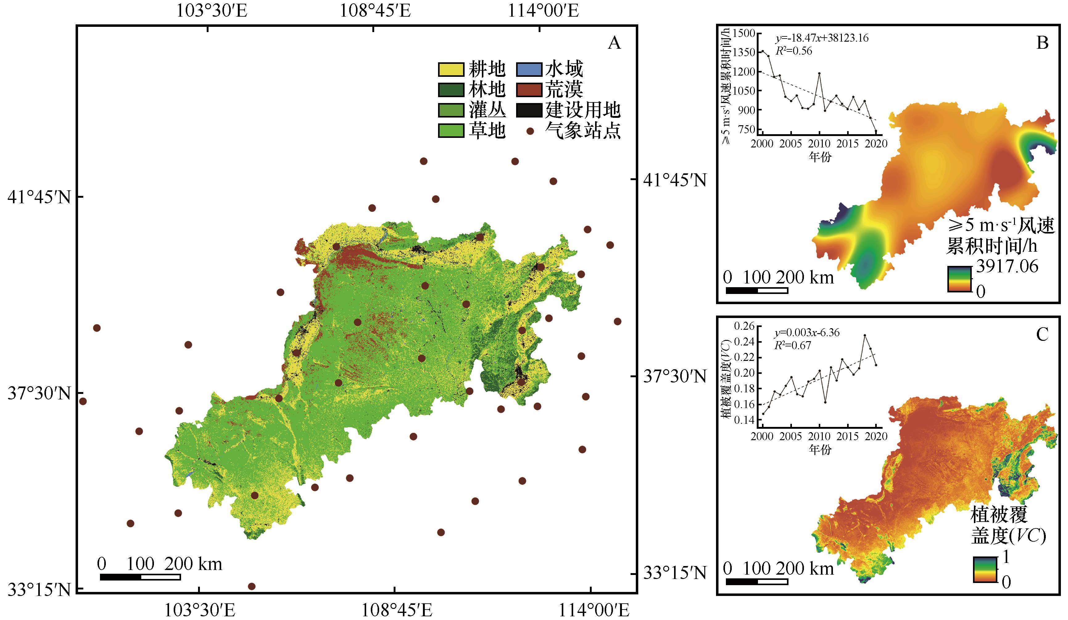
Fig.1 Spatial patterns of (A) land use, (B) cumulative time of wind speed (≥5 m·s-1) and (C) vegetation coverage in wind erosion area of the northern Loess Plateau
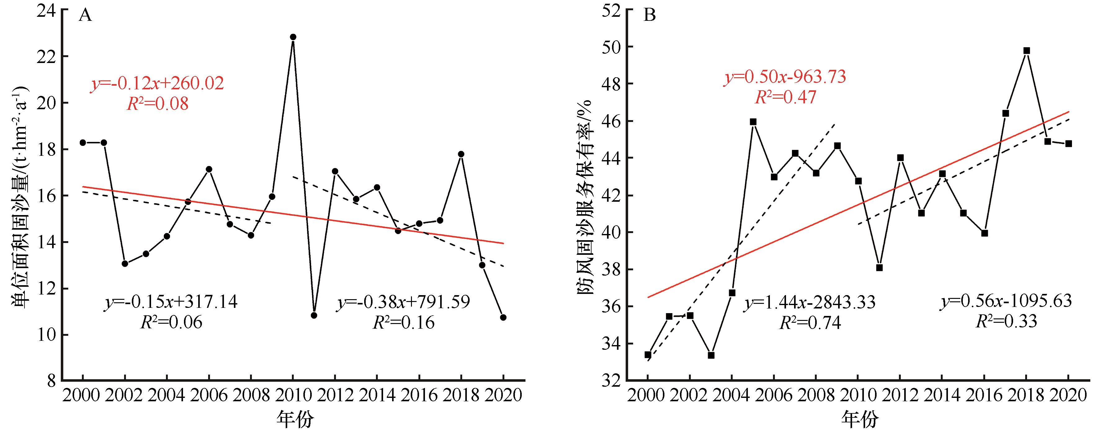
Fig.2 Annual variation of sand fixation per unit area and windbreak and sand fixation services retention rate in wind erosion area of the northern Loess Plateau during 2000-2020
| 等级 | 分级标准 /(t·hm-2) | 平均单位面积固沙量/(t·hm-2·a-1) | 面积占比/% | ||||
|---|---|---|---|---|---|---|---|
| 2000—2020年 | 2000—2009年 | 2010—2020年 | 2000—2020年 | 2000—2009年 | 2010—2020年 | ||
| 低 | 0~2 | 0.46 | 0.42 | 0.42 | 62.67 | 63.25 | 61.48 |
| 较低 | 2~10 | 4.48 | 4.50 | 4.56 | 16.40 | 15.94 | 17.43 |
| 中 | 10~25 | 16.27 | 16.23 | 16.27 | 5.53 | 5.28 | 5.93 |
| 较高 | 25~80 | 52.11 | 51.25 | 50.57 | 6.42 | 6.18 | 6.69 |
| 高 | >80 | 112.16 | 112.38 | 117.23 | 8.97 | 9.35 | 8.47 |
Table 1 Classification and proportion of sand fixation per unit area in the wind erosion area of the northern Loess Plateau in three periods
| 等级 | 分级标准 /(t·hm-2) | 平均单位面积固沙量/(t·hm-2·a-1) | 面积占比/% | ||||
|---|---|---|---|---|---|---|---|
| 2000—2020年 | 2000—2009年 | 2010—2020年 | 2000—2020年 | 2000—2009年 | 2010—2020年 | ||
| 低 | 0~2 | 0.46 | 0.42 | 0.42 | 62.67 | 63.25 | 61.48 |
| 较低 | 2~10 | 4.48 | 4.50 | 4.56 | 16.40 | 15.94 | 17.43 |
| 中 | 10~25 | 16.27 | 16.23 | 16.27 | 5.53 | 5.28 | 5.93 |
| 较高 | 25~80 | 52.11 | 51.25 | 50.57 | 6.42 | 6.18 | 6.69 |
| 高 | >80 | 112.16 | 112.38 | 117.23 | 8.97 | 9.35 | 8.47 |
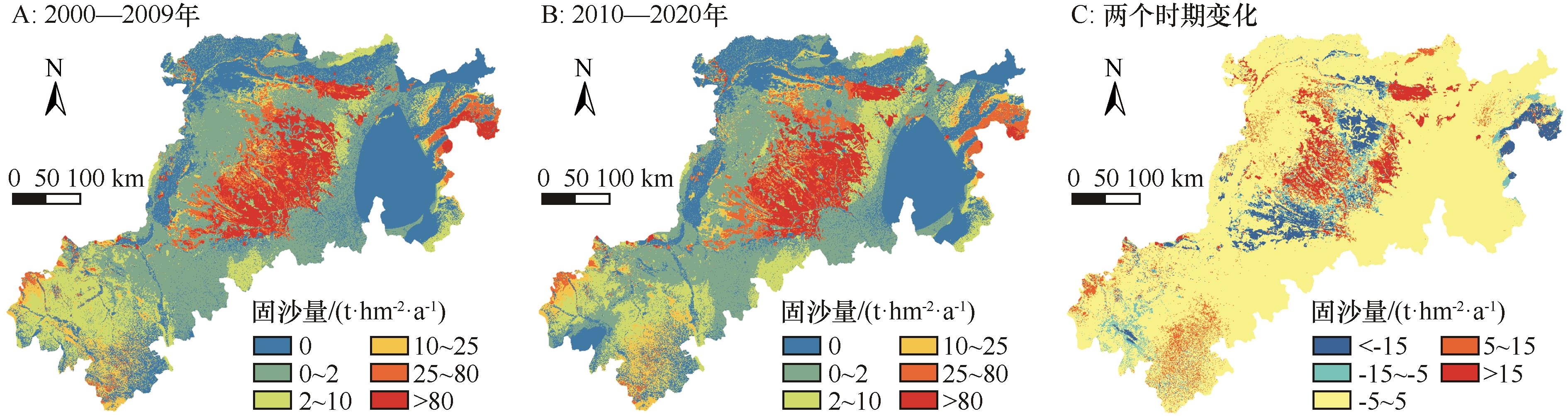
Fig.3 Spatial pattern and variation characteristics of sand fixation per unit area in wind erosion area of the northern Loess Plateau
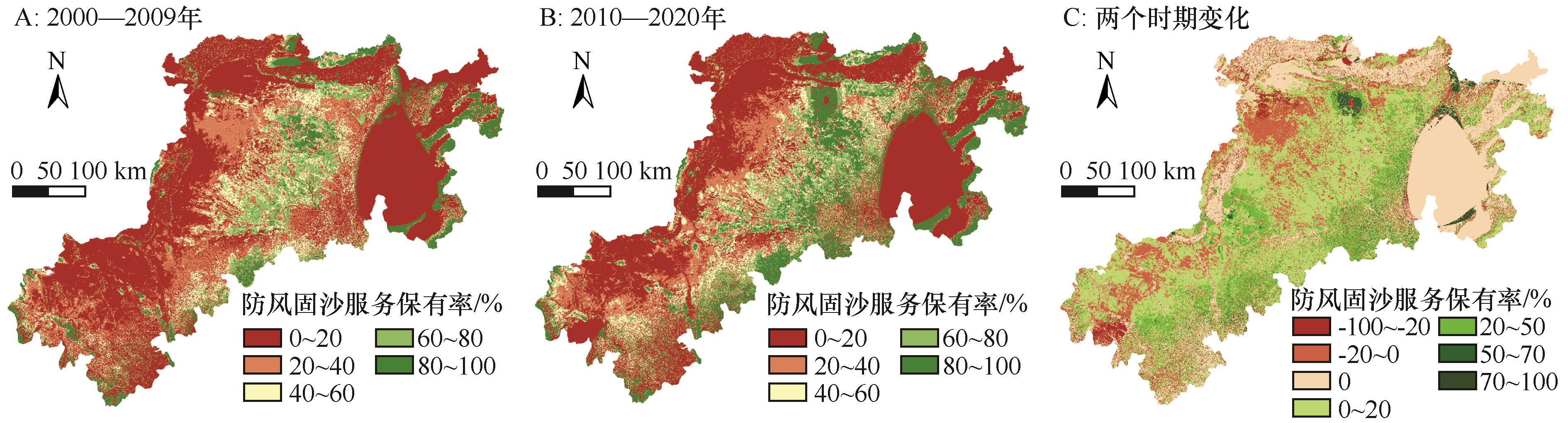
Fig.4 Spatial pattern and change characteristics of windbreak and sand fixation services retention rate in wind erosion area of the northern Loess Plateau
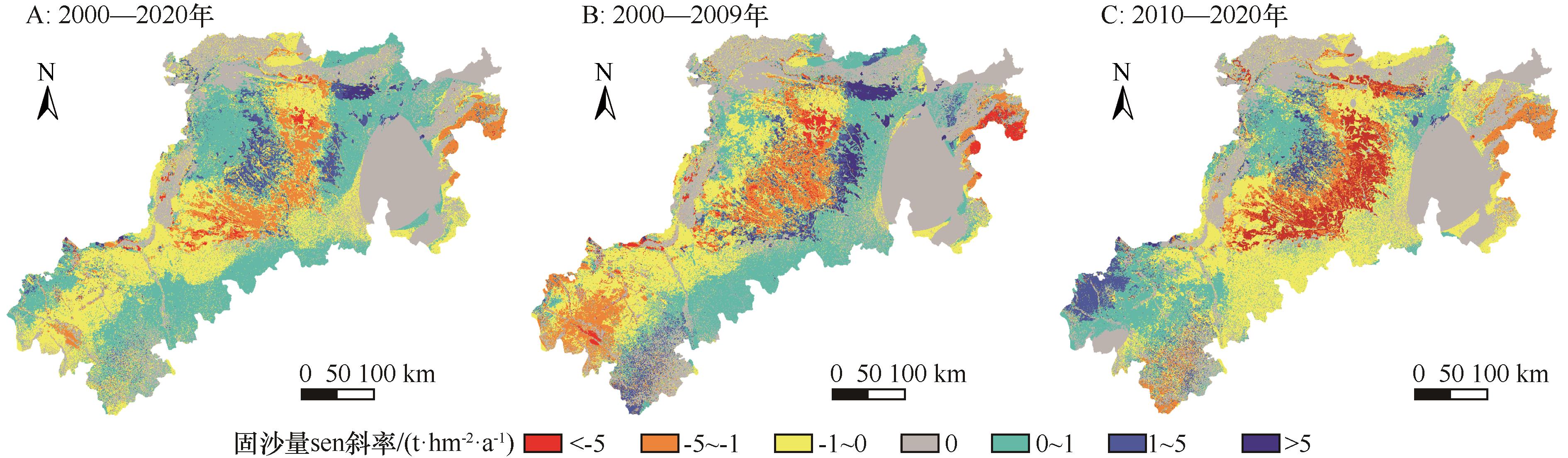
Fig.5 Annual variation rate of sand fixation per unit area in wind erosion area of the northern Loess Plateau
| 项目 | 研究时段 | 耕地 | 林地 | 灌丛 | 草地 | 荒漠 | 建设用地 | 水域 |
|---|---|---|---|---|---|---|---|---|
| 土地利用/万km2及变化率 | P1(2000—2009年) | 9.41 | 1.10 | 0.07 | 22.11 | 2.47 | 0.47 | 0.16 |
| P2(2010—2020年) | 8.81 | 1.25 | 0.05 | 22.94 | 1.86 | 0.70 | 0.18 | |
| P1-P2变化量 | -0.60 | 0.15 | -0.02 | 0.83 | -0.61 | 0.24 | 0.02 | |
| P1-P2变化率/% | -6.42 | 13.85 | -31.93 | 3.77 | -24.85 | 50.72 | 12.00 | |
| 平均单位面积固沙量 /(t·hm-2·a-1) 及变化率 | P1(2000—2009年) | 7.20 | 15.50 | 15.89 | 18.31 | 24.63 | 3.48 | 2.82 |
| P2(2010—2020年) | 7.85 | 11.61 | 12.67 | 18.73 | 16.99 | 3.68 | 2.36 | |
| P1-P2变化量 | 0.65 | -3.89 | -3.22 | 0.42 | -7.65 | 0.20 | -0.46 | |
| P1-P2变化率/% | 8.98 | -25.11 | -20.26 | 2.30 | -31.04 | 5.70 | -16.25 | |
平均固沙量/(亿t·a-1) 及贡献率 | P1(2000—2009年) | 0.68 | 0.17 | 0.012 | 4.04 | 0.61 | 0.02 | 0.0045 |
| P1贡献率/% | 12.23 | 3.06 | 0.21 | 73.05 | 11.09 | 0.29 | 0.08 | |
| P2(2010—2020年) | 0.69 | 0.18 | 0.006 | 4.30 | 0.32 | 0.03 | 0.0043 | |
| P2贡献率/% | 12.52 | 3.26 | 0.11 | 77.82 | 5.74 | 0.47 | 0.08 | |
| 年均防风固沙服务 保有率/% | P1(2000—2009年) | 27.50 | 95.05 | 98.41 | 47.05 | 20.88 | 29.38 | 31.37 |
| P2(2010—2020年) | 31.51 | 95.53 | 99.23 | 54.78 | 13.18 | 33.19 | 34.70 | |
| P1-P2变化量 | 4.01 | 0.48 | 0.82 | 7.73 | -7.70 | 3.80 | 3.33 |
Table 2 Sand fixation and annual average windbreak and sand fixation services retention rate of different land use types in wind erosion area of the northern Loess Plateau in 2000-2009 and 2010-2020
| 项目 | 研究时段 | 耕地 | 林地 | 灌丛 | 草地 | 荒漠 | 建设用地 | 水域 |
|---|---|---|---|---|---|---|---|---|
| 土地利用/万km2及变化率 | P1(2000—2009年) | 9.41 | 1.10 | 0.07 | 22.11 | 2.47 | 0.47 | 0.16 |
| P2(2010—2020年) | 8.81 | 1.25 | 0.05 | 22.94 | 1.86 | 0.70 | 0.18 | |
| P1-P2变化量 | -0.60 | 0.15 | -0.02 | 0.83 | -0.61 | 0.24 | 0.02 | |
| P1-P2变化率/% | -6.42 | 13.85 | -31.93 | 3.77 | -24.85 | 50.72 | 12.00 | |
| 平均单位面积固沙量 /(t·hm-2·a-1) 及变化率 | P1(2000—2009年) | 7.20 | 15.50 | 15.89 | 18.31 | 24.63 | 3.48 | 2.82 |
| P2(2010—2020年) | 7.85 | 11.61 | 12.67 | 18.73 | 16.99 | 3.68 | 2.36 | |
| P1-P2变化量 | 0.65 | -3.89 | -3.22 | 0.42 | -7.65 | 0.20 | -0.46 | |
| P1-P2变化率/% | 8.98 | -25.11 | -20.26 | 2.30 | -31.04 | 5.70 | -16.25 | |
平均固沙量/(亿t·a-1) 及贡献率 | P1(2000—2009年) | 0.68 | 0.17 | 0.012 | 4.04 | 0.61 | 0.02 | 0.0045 |
| P1贡献率/% | 12.23 | 3.06 | 0.21 | 73.05 | 11.09 | 0.29 | 0.08 | |
| P2(2010—2020年) | 0.69 | 0.18 | 0.006 | 4.30 | 0.32 | 0.03 | 0.0043 | |
| P2贡献率/% | 12.52 | 3.26 | 0.11 | 77.82 | 5.74 | 0.47 | 0.08 | |
| 年均防风固沙服务 保有率/% | P1(2000—2009年) | 27.50 | 95.05 | 98.41 | 47.05 | 20.88 | 29.38 | 31.37 |
| P2(2010—2020年) | 31.51 | 95.53 | 99.23 | 54.78 | 13.18 | 33.19 | 34.70 | |
| P1-P2变化量 | 4.01 | 0.48 | 0.82 | 7.73 | -7.70 | 3.80 | 3.33 |
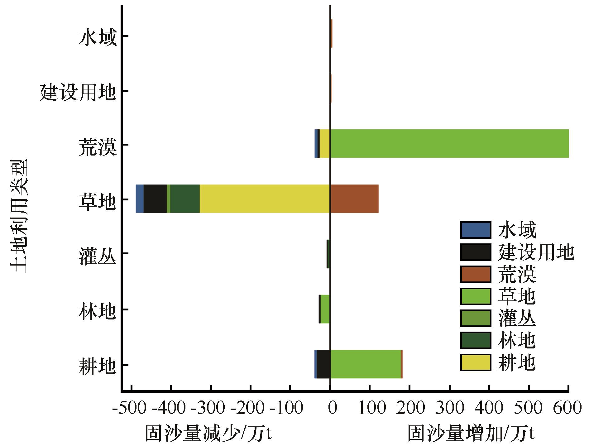
Fig.6 Variation in sand fixation caused by different land use type transition from 2000 to 2020
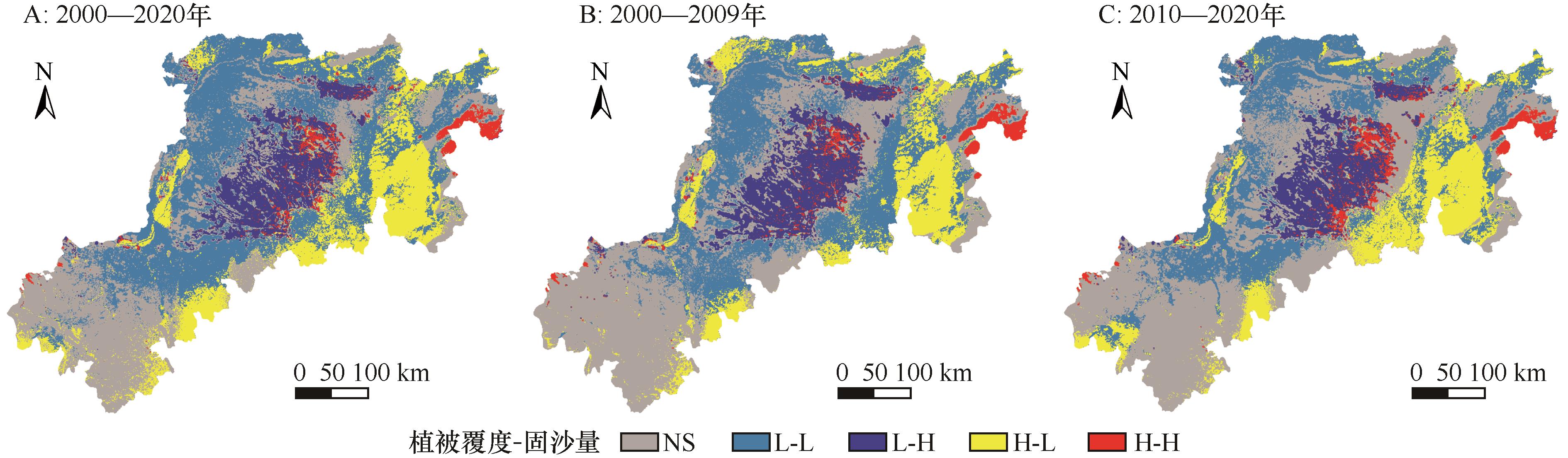
Fig.7 Local LISA plots of vegetation coverage and sand fixation per unit area in wind erosion area of the northern Loess Plateau from 2000 to 2020
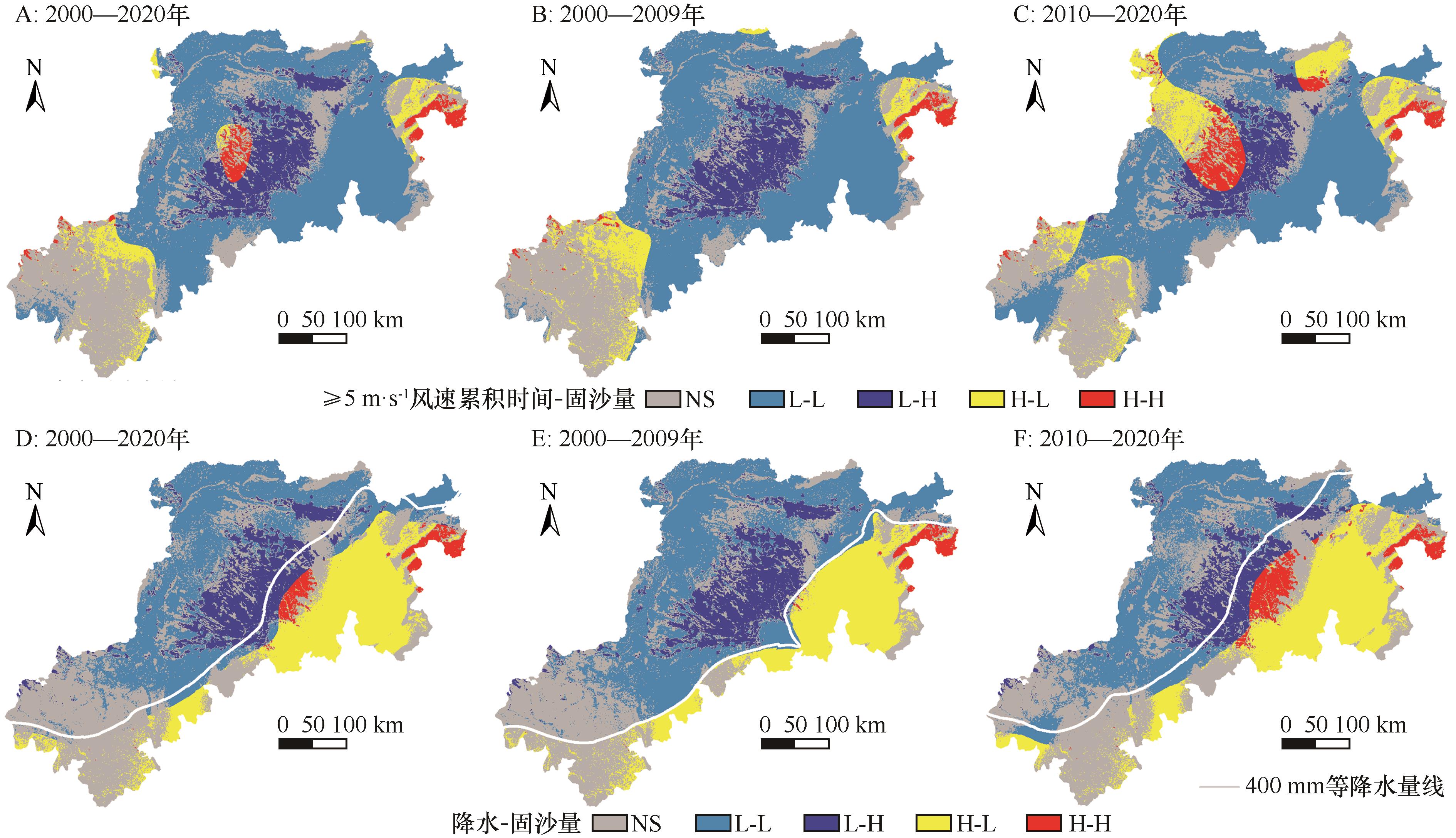
Fig.8 Local LISA plots for cumulative time of wind speed(≥5 m·s-1)/precipitation and sand fixation per unit area in wind erosion area of the northern Loess Plateau during 2000-2020
| 1 | 肖玉,谢高地,甄霖,等.北麓草原生态功能区防风固沙服务受益范围识别[J].自然资源学报,2018,33(10):1742-1754. |
| 2 | Li D J, Xu D Y, Wang Z Y,et al.The dynamics of sand-stabilization services in Inner Mongolia,China from 1981 to 2010 and its relationship with climate change and human activities[J].Ecological Indicators,2018,88:351-360. |
| 3 | 元天刚,陈思宇,康丽泰,等.1961-2010年中国北方沙尘源区沙尘强度时空分布特征及变化趋势[J].干旱气象,2016,34(6):927-935. |
| 4 | 张彪,李庆旭,王爽,等.京津风沙源区防风固沙功能的时空变化及其区域差异[J].自然资源学报,2019,34(5):1041-1053. |
| 5 | 张彪,王爽,李庆旭,等.基于防风固沙服务空间流动的区域关联度:以京津风沙源治理工程区为例[J].资源科学,2020,42(5):969-979. |
| 6 | 张照营.北方防沙屏障带防风固沙生态系统服务功能变化评估[D].西安:长安大学,2017. |
| 7 | Xu J, Xiao Y, Xie G D,et al.Assessment of the benefit diffusion of windbreak and sand fixation service in National Key Ecological Function areas in China[J].Aeolian Research,2021,52:100728. |
| 8 | Hu W, Wu X, Zhang K.Spatiotemporal change of beneficiary area from wind erosion prevention service in the Ulan Buh Desert in 2008 and 2018[J].Geography and Sustainability,2022,3(2):119-128. |
| 9 | Li D J, Xu D Y.Sand fixation function response to climate change and land use in northern China from 1981 to 2015[J].Aeolian Research,2019,40:23-33. |
| 10 | 江凌,肖燚,饶恩明,等.内蒙古土地利用变化对生态系统防风固沙功能的影响[J].生态学报,2016,36(12):3734-3747. |
| 11 | 朱趁趁,龚吉蕊,杨波,等.内蒙古荒漠草原防风固沙服务变化及其驱动力[J].生态学报,2021,41(11):4606-4617. |
| 12 | 王夏青,张秀云,周强,等.清末“回民起义”时期黄土高原中部土壤侵蚀和人地关系演变[J].地理科学,2022,42(2):303-313. |
| 13 | 王夏青,夏梦婷,许建伟,等.黄土高原北部丘陵沟壑区近160年土壤侵蚀量演变及其对ENSO事件的响应[J].地理科学,2019,39(7): 1174-1183. |
| 14 | 李晶,任志远.陕北黄土高原土地利用防风固沙功能价值时空研究[J].干旱区资源与环境,2011,25(7):183-187. |
| 15 | Chi W F, Zhao Y Y, Kuang W H,et al.Impacts of anthropogenic land use/cover changes on soil wind erosion in China[J].Science of the Total Environment,2019,668:204-215. |
| 16 | Meng Z, Dang X, Gao Y,et al.Interactive effects of wind speed,vegetation coverage and soil moisture in controlling wind erosion in a temperate desert steppe,Inner Mongolia of China[J].Journal of Arid Land,2018,10(2):1-14. |
| 17 | 张彪,王爽,史芸婷.京津风沙源区防风固沙功能对植被覆盖度变化的时空响应研究[J].生态科学,2022,41(1):110-119. |
| 18 | Huang T, Yu D.Water-soil conservation services dynamic and its implication for landscape management in a fragile semiarid landscape[J].Ecological Indicators,2021,130:108150. |
| 19 | Bu C F, Zhao Y, Hill R L,et al.Wind erosion prevention characteristics and key influencing factors of bryophytic soil crusts[J].Plant and Soil,2015,397(1/2):163-174. |
| 20 | Bergametti G, Rajot J L, Pierre C,et al.How long does precipitation inhibit wind erosion in the Sahel?[J].Geophysical Research Letters,2016,43(12):6643-6649. |
| 21 | Teng Y M, Zhan J Y, Liu W,et al.Spatiotemporal dynamics and drivers of wind erosion on the Qinghai-Tibet Plateau,China[J].Ecological Indicators,2021,123:107340. |
| 22 | 彭婉月,兆云,李海东,等.黑河中下游防风固沙功能时空变化及影响因子分析[J].环境科学研究,2020,33(12):2734-2744. |
| 23 | 韩柳,王静璞,王光镇,等.中国北方风蚀区风速变化时空特征分析[J].干旱区地理,2018,41(5):963-971. |
| 24 | 顾朝军,穆兴民,高鹏,等.1961-2014年黄土高原地区降水和气温时间变化特征研究[J].干旱区资源与环境,2017,31(3):136-143. |
| 25 | 李相儒,金钊,张信宝,等.黄土高原近60年生态治理分析及未来发展建议[J].地球环境学报,2015,6(4):248-254. |
| 26 | 王旭洋,郭中领,常春平,等.中国北方农牧交错带土壤风蚀时空分布[J].中国沙漠,2020,40(1):12-22. |
| 27 | 于宝勒,吴文俊,赵学军,等.内蒙古京津风沙源治理工程土壤风蚀控制效益研究[J].干旱区研究,2016,33(6):1278-1286. |
| 28 | 高尚玉.京津风沙源治理工程效益[M].北京:科学出版社,2012. |
| 29 | Zhai T L, Wang J, Jin Z F,et al.Did improvements of ecosystem services supply-demand imbalance change environmental spatial injustices?[J].Ecological Indicators,2020,111:106068. |
| 30 | 赵雪雁,马平易,李文青,等.黄土高原生态系统服务供需关系的时空变化[J].地理学报,2021,76(11):2780-2796. |
| 31 | 何旭宁,于皓,王宗明.基于多源数据的内蒙古东部地区防风固沙能力变化研究[J].测绘与空间地理信息,2019,42(7):138-141. |
| 32 | 宁佳,邵全琴.黄土高原土地利用及生态系统服务时空变化特征研究[J].农业环境科学学报,2020,39(4):774-785. |
| 33 | 王晓峰,马嘉豪,冯晓明,等.黄河流域生态安全屏障的防风固沙服务时空变化及驱动因素分析[J].生态学报,2023,43(2):1-13. |
| 34 | Xavier R L, Wouter B, Gerardo B.Land use can offset climate change induced increases in erosion in Mediterranean watersheds[J].CATENA,2016,143:244-255. |
| 35 | 张华,季媛,苗苗.科尔沁沙地土地利用与耕作方式对土壤风蚀的影响[J].干旱区地理,2006,29(6):861-866. |
| 36 | Zhao Y Y, Wu J G, He C Y,et al.Linking wind erosion to ecosystem services in drylands:a landscape ecological approach[J].Landscape Ecology,2017,32(12):2399-2417. |
| 37 | 秦丽娟.河北坝上地区植树造林防风固沙效果研究[D].石家庄:河北师范大学,2020. |
| 38 | 谭勇,王长如,梁宗锁,等.黄土高原半干旱区林草植被建设措施[J].草业学报,2006,15(4):4-11. |
| 39 | 杨钦,郭中领,王仁德,等.河北坝上不同土地利用方式对土壤风蚀的影响[J].干旱区资源与环境,2017,31(2):185-190. |
| 40 | Cao S X, Zhang J Z, Chen L,et al.Ecosystem water imbalances created during ecological restoration by afforestation in China,and lessons for other developing countries[J].Journal of Environmental Management,2016,183:843-849. |
| 41 | 韩永伟,拓学森,高吉喜,等.黑河下游重要生态功能区防风固沙功能辐射效益[J].生态学报,2010,30(19):5185-5193. |
| 42 | 宋超,余琦殷,王瑞霞,等.基于植被覆盖度的宁夏灵武白芨滩自然保护区防风固沙功能时空变化研究[J].生态学报,2021,41(8):3131-3143. |
| 43 | Zhang M M, Wu X Q.The rebound effects of recent vegetation restoration projects in Mu Us Sandy Land of China[J].Ecological Indicators,2020,113:106228. |
| 44 | Zhao C N, Zhang H B, Wang M,et al.Impacts of climate change on wind erosion in Southern Africa between 1991 and 2015[J].Land Degradation & Development,2021,32(6):2169-2182. |
| 45 | 卢珊,胡泽勇,付春伟,等.黄土高原夏季极端降水及其成因分析[J].高原气象,2022,41(1):241-254. |
| 46 | 马芹,张晓萍,万龙,等.1957-2009年黄土高原地区风速变化趋势[J].自然资源学报,2012,27(12):2123-2134. |
| [1] | Jun Liu, Zhongling Guo, Chunping Chang, Rende Wang, Jifeng Li, Qing Li, Xuyang Wang. Potential wind erosion simulation in the agro-pastoral ecotone of northern China using RWEQ and WEPS models [J]. Journal of Desert Research, 2021, 41(2): 27-37. |
| [2] | Zhenyan Liu, Chunping Chang, Zhongling Guo, Jifeng Li, Rende Wang, Qing Li, Yapeng Huang, Xu Li, Jun Liu, Zhensheng Su. A comparative study on field test of sand collectors [J]. Journal of Desert Research, 2020, 40(6): 33-42. |
| [3] | Wang Xuyang, Guo Zhongling, Chang Chunping, Wang Rende, Li Jifeng, Li qing, Qin Lijuan. Spatiotemporal distribution of soil wind erosion modulus in the agro-pastoral ecotone of north China [J]. Journal of Desert Research, 2020, 40(1): 12-22. |
| [4] | Sun Lifan, Shi Xingmin, Wang Lu. Assessments of the Efficacy of Farmers' Adaptive Behaviors to Climate Change [J]. JOURNAL OF DESERT RESEARCH, 2018, 38(2): 428-436. |
| [5] | Wu Zhitao, Guo Weixu, Li Jinchang, Zhang Hong, Zhang Xiaoyu. Design of Wind-blown Sand Environment Information Service System in the Desertification Region of Northern Shanxi, China [J]. JOURNAL OF DESERT RESEARCH, 2015, 35(5): 1150-1155. |
| [6] | SUN Zhi-hui1,2, WANG Zhi-liang1,2, CAO Xue-mei1,2, YANG Qiong1,2, LIU Zhi-chao1,2, LEI Yan-peng1,2. Characteristics of Drought Change in the Loess Plateau Area of Shaanxi Based on the Standardized Precipitation Index during 1971-2010 [J]. JOURNAL OF DESERT RESEARCH, 2013, 33(5): 1560-1567. |
| [7] | YAN Ming1, WANG Cai-xia2, WANG Sui-ji1, YAN Yun-xia1, XU Jiong-xin1 . Spatial-temporal Variation of Sand-dust Storms and Precipitation during 1958-2007 in the Loess Plateau [J]. JOURNAL OF DESERT RESEARCH, 2013, 33(3): 850-856. |
| [8] | QU Guang-zhou;QIN Ying-hong;LIU Liang;HUANG Yi-jun. Analysis of Water Resources Variation of Yellow River and Main River in the Loess Plateau with R/S Method [J]. JOURNAL OF DESERT RESEARCH, 2010, 30(2): 467-470. |
| [9] | WANG Guo-li;CHEN Ying-wu;LIU Chang-zhong;HOU Fu-jiang;YANG Bao-sheng;WANG Sen-shan. Effects of Eco-restoration of Abandoned Farmland on Soil Invertebrate Diversity in the Loess Plateau [J]. JOURNAL OF DESERT RESEARCH, 2010, 30(1): 140-145. |
| [10] | CHEN Shao yong;DONG An xiang. Climatic Response of Soil Moisture on Loess Plateau in China [J]. JOURNAL OF DESERT RESEARCH, 2008, 28(1): 66-72. |
| [11] | YE Yan-hua;LI Dong-liang;CHEN Xiao-guang. Response of Spring Precipitation in Loess Plateau to Surface Sensible Heat in Qinghai-Xizang Plateau [J]. JOURNAL OF DESERT RESEARCH, 2007, 27(2): 315-319. |
| [12] | DUAN Zheng-hu;XIAO Hong-lang;SONG Yao-xuan;CHENG Guo-dong. Soil Water Variation in Different Terrains and Influence on Plant in Lanzhou Suburb on Western Loess Plateau [J]. JOURNAL OF DESERT RESEARCH, 2006, 26(4): 522-526. |
| [13] | DUAN Zheng-hu;XIAO Hong-lang;SONG Yao-xuan. Soil Water Deficit and Control in Planted Forest in Lanzhou Suburb on Western Loess Plateau [J]. JOURNAL OF DESERT RESEARCH, 2006, 26(4): 527-531. |
| [14] | ZHAO Jing-bo, LI Yu-qin. Effects of Soil-drying Layer on Afforestation in the Loess Plateau of Shaanxi [J]. JOURNAL OF DESERT RESEARCH, 2005, 25(3): 370-373. |
| [15] | ZHAO Jing-bo, HOU Yong-jian, HUANG Chun-chang. Causes and Countermeasures of Soil Drying under Artificial Forest on the Loess Plateau in Northern Shaanxi [J]. JOURNAL OF DESERT RESEARCH, 2003, 23(6): 612-615. |
| Viewed | ||||||
|
Full text |
|
|||||
|
Abstract |
|
|||||
©2018Journal of Desert Research
Tel:0931-8267545
Email:caiedit@lzb.ac.cn;desert@lzb.ac.cn
Support:Magtech