
- CN 62-1070/P
- ISSN 1000-694X
- Bimonthly 1981
Journal of Desert Research ›› 2024, Vol. 44 ›› Issue (1): 61-74.DOI: 10.7522/j.issn.1000-694X.2023.00068
Previous Articles Next Articles
Xia Li1,2( ), Bao Yang1()
Received:2023-03-12
Revised:2023-05-16
Online:2024-01-20
Published:2023-12-26
Contact:
Bao Yang
CLC Number:
Xia Li, Bao Yang. Dynamic downscaling simulation of temperature and precipitation in the Qilian Mountains and its surrounding areas[J]. Journal of Desert Research, 2024, 44(1): 61-74.
Add to citation manager EndNote|Ris|BibTeX
URL: http://www.desert.ac.cn/EN/10.7522/j.issn.1000-694X.2023.00068
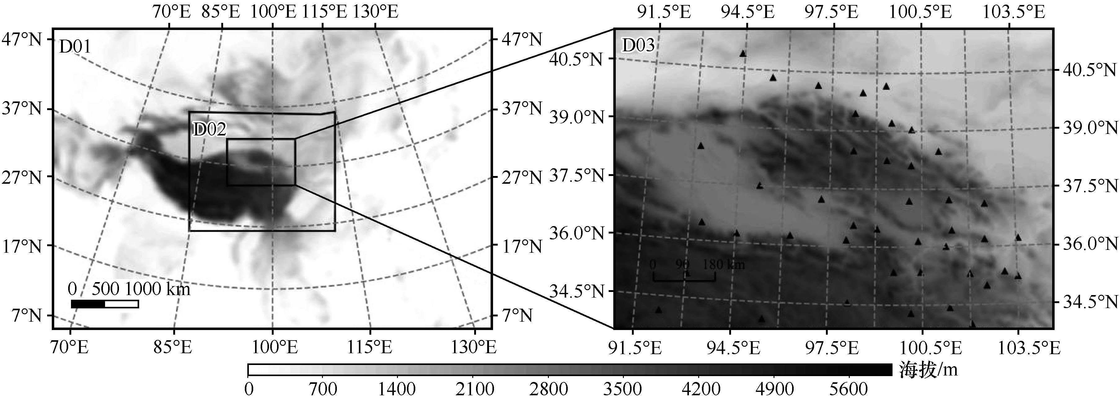
Fig.1 WRF simulation of nested areas, altitude and weather station distribution
| 方案 | 云微物理过程 | 积云对流 | 长波辐射 | 短波辐射 | 边界层 | 近地层 | 陆面过程 |
|---|---|---|---|---|---|---|---|
| Case A | WSM6 | Kain-Fritsch | CAM | CAM | YSU | MM5 | Noah |
| Case B | WSM6 | Kain-Fritsch | RRTM | Dudhia | YSU | MM5 | Noah |
| Case C | WSM6 | Grell-Devenyi | RRTM | Dudhia | YSU | MM5 | Noah |
| Case D | Thompson | Grell-Devenyi | RRTM | Dudhia | YSU | MM5 | Noah |
| Case E | Thompson | Kain-Fritsch | RRTM | Dudhia | YSU | MM5 | Noah |
Table 1 Parametric programme combinations
| 方案 | 云微物理过程 | 积云对流 | 长波辐射 | 短波辐射 | 边界层 | 近地层 | 陆面过程 |
|---|---|---|---|---|---|---|---|
| Case A | WSM6 | Kain-Fritsch | CAM | CAM | YSU | MM5 | Noah |
| Case B | WSM6 | Kain-Fritsch | RRTM | Dudhia | YSU | MM5 | Noah |
| Case C | WSM6 | Grell-Devenyi | RRTM | Dudhia | YSU | MM5 | Noah |
| Case D | Thompson | Grell-Devenyi | RRTM | Dudhia | YSU | MM5 | Noah |
| Case E | Thompson | Kain-Fritsch | RRTM | Dudhia | YSU | MM5 | Noah |
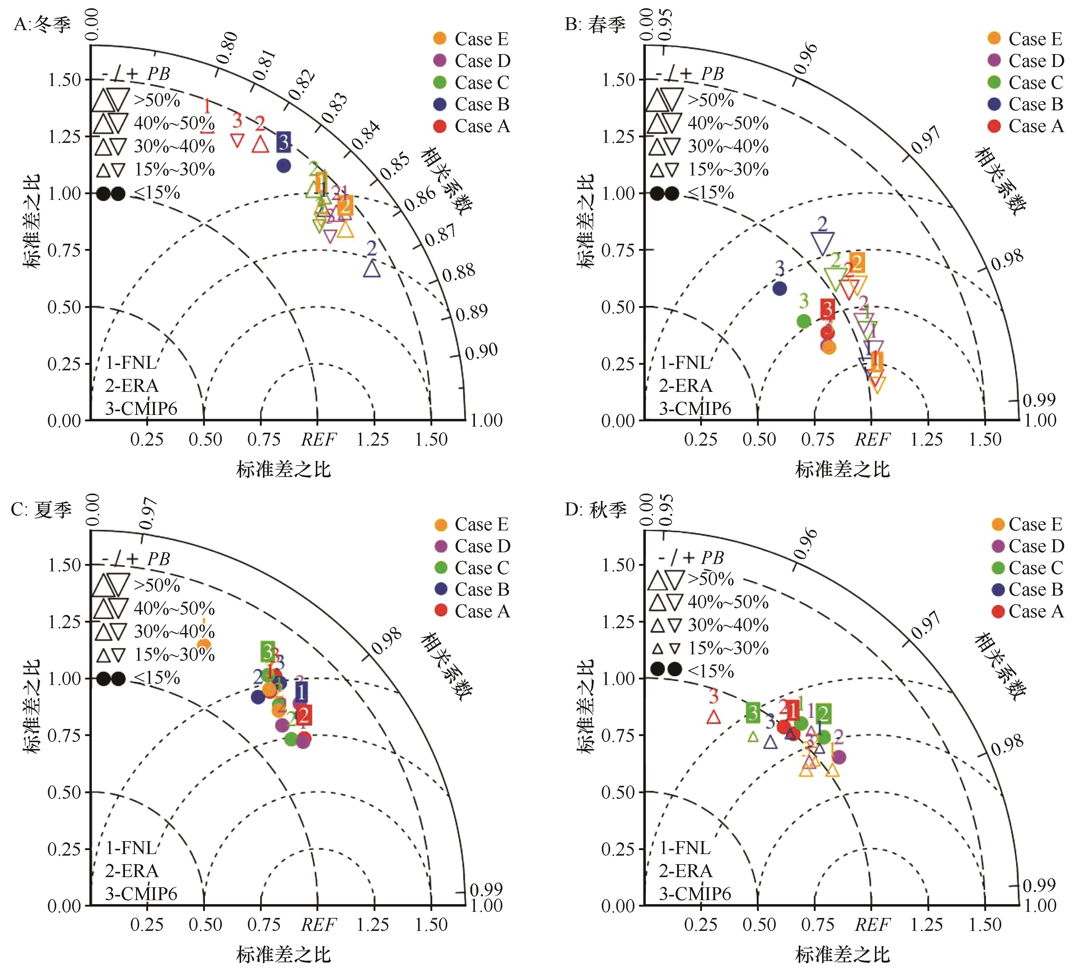
Fig.2 Average daily temperatures averaged over the four seasons of winter, spring, summer and autumn Taylor diagram
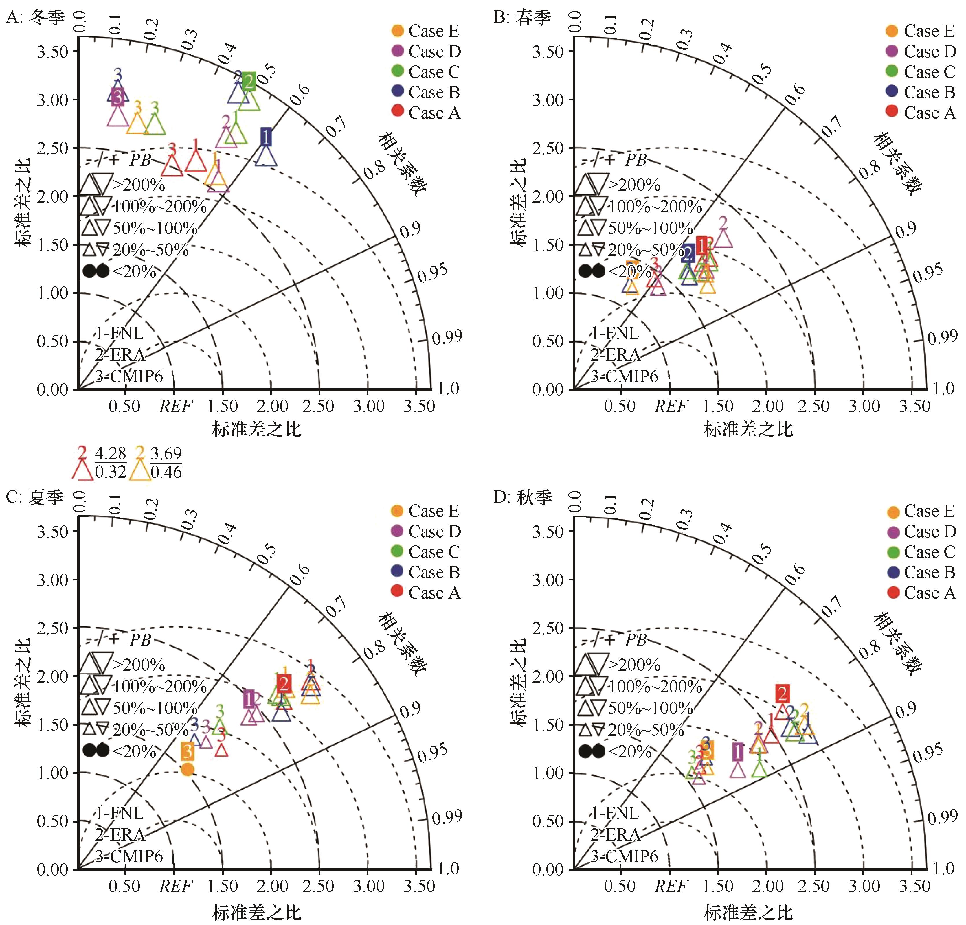
Fig.3 Average daily precipitation for the four seasons of winter, spring, summer and autumn Taylor diagram
| TM | 地形资料 | 冬季 | 春季 | 夏季 | 秋季 |
|---|---|---|---|---|---|
| R | 默认 | 0.8514 | 0.9834 | 0.9811 | 0.9694 |
| SRTM3 | 0.8456 | 0.9848 | 0.9800 | 0.9700 | |
| RMSE | 默认 | 2.1529 | 0.9702 | 1.2508 | 1.0850 |
| SRTM3 | 2.1583 | 0.9122 | 1.3001 | 1.0944 | |
| σ | 默认 | 1.4450 | 1.0548 | 1.1808 | 1.0627 |
| SRTM3 | 1.4336 | 1.0444 | 1.1896 | 1.0751 | |
| PB | 默认 | 23.13% | -43.57% | -4.77% | 10.32% |
| SRTM3 | 22.61% | -43.27% | -4.49% | 4.99% |
Table 2 Results of simulated temperature assessment for two sets of topographic data
| TM | 地形资料 | 冬季 | 春季 | 夏季 | 秋季 |
|---|---|---|---|---|---|
| R | 默认 | 0.8514 | 0.9834 | 0.9811 | 0.9694 |
| SRTM3 | 0.8456 | 0.9848 | 0.9800 | 0.9700 | |
| RMSE | 默认 | 2.1529 | 0.9702 | 1.2508 | 1.0850 |
| SRTM3 | 2.1583 | 0.9122 | 1.3001 | 1.0944 | |
| σ | 默认 | 1.4450 | 1.0548 | 1.1808 | 1.0627 |
| SRTM3 | 1.4336 | 1.0444 | 1.1896 | 1.0751 | |
| PB | 默认 | 23.13% | -43.57% | -4.77% | 10.32% |
| SRTM3 | 22.61% | -43.27% | -4.49% | 4.99% |
| PR | 地形资料 | 冬季 | 春季 | 夏季 | 秋季 |
|---|---|---|---|---|---|
| R | 默认 | 0.5600 | 0.7439 | 0.7488 | 0.8537 |
| SRTM3 | 0.5635 | 0.7671 | 0.7610 | 0.8501 | |
| RMSE | 默认 | 0.1220 | 0.5701 | 1.9509 | 0.5111 |
| SRTM3 | 0.1281 | 0.5527 | 2.5444 | 0.5176 | |
| σ | 默认 | 2.6045 | 1.8488 | 2.3639 | 1.9915 |
| SRTM3 | 2.7283 | 1.8421 | 2.9436 | 2.0027 | |
| PB | 默认 | 278.60% | 79.12% | 89.90% | 62.41% |
| SRTM3 | 283.58% | 85.68% | 114.29% | 67.88% |
Table 3 Results of simulated precipitation assessment for two sets of topographic data
| PR | 地形资料 | 冬季 | 春季 | 夏季 | 秋季 |
|---|---|---|---|---|---|
| R | 默认 | 0.5600 | 0.7439 | 0.7488 | 0.8537 |
| SRTM3 | 0.5635 | 0.7671 | 0.7610 | 0.8501 | |
| RMSE | 默认 | 0.1220 | 0.5701 | 1.9509 | 0.5111 |
| SRTM3 | 0.1281 | 0.5527 | 2.5444 | 0.5176 | |
| σ | 默认 | 2.6045 | 1.8488 | 2.3639 | 1.9915 |
| SRTM3 | 2.7283 | 1.8421 | 2.9436 | 2.0027 | |
| PB | 默认 | 278.60% | 79.12% | 89.90% | 62.41% |
| SRTM3 | 283.58% | 85.68% | 114.29% | 67.88% |
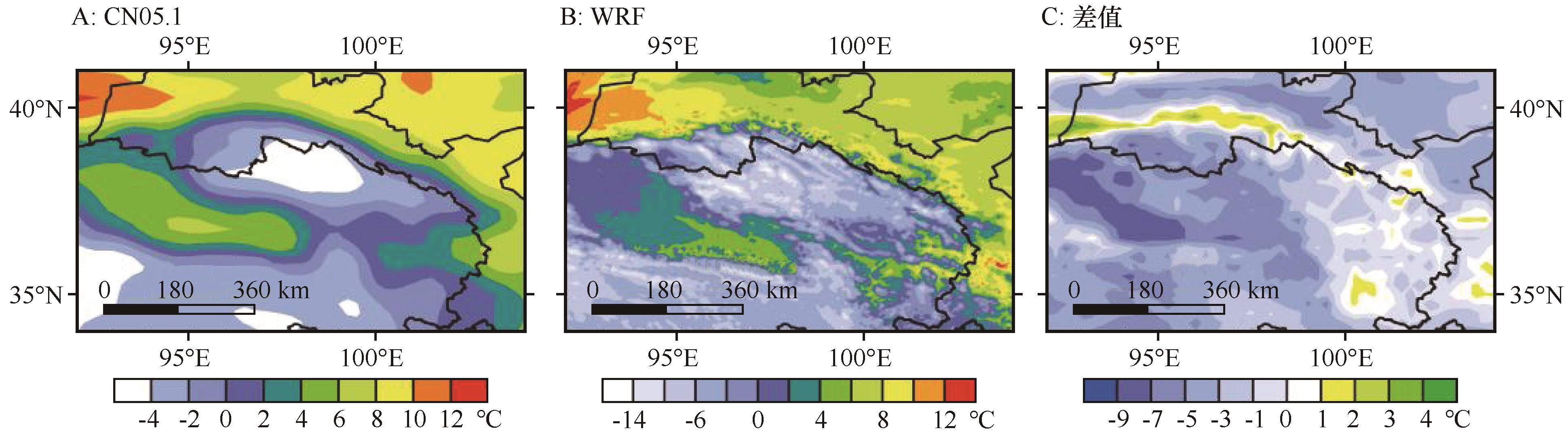
Fig.4 Spatial distribution of observed (A) and modelled (B) annual mean temperatures and spatial distribution of the difference between the two (C) for 2005-2014
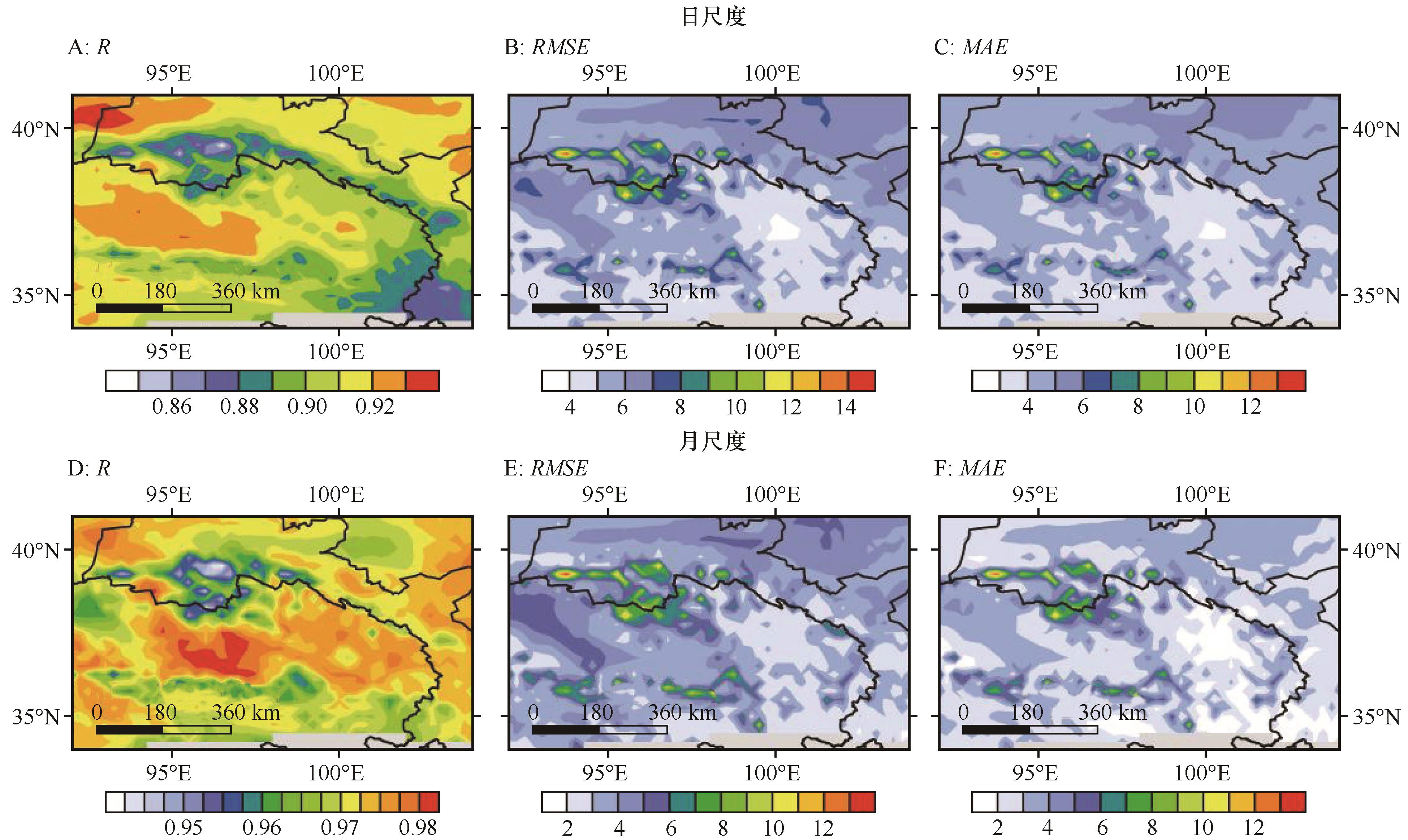
Fig.5 Spatial distribution of daily(A, B, C) and monthly (D, E, F) scale temperature spatial correlation coefficients, root mean square errors and absolute deviations
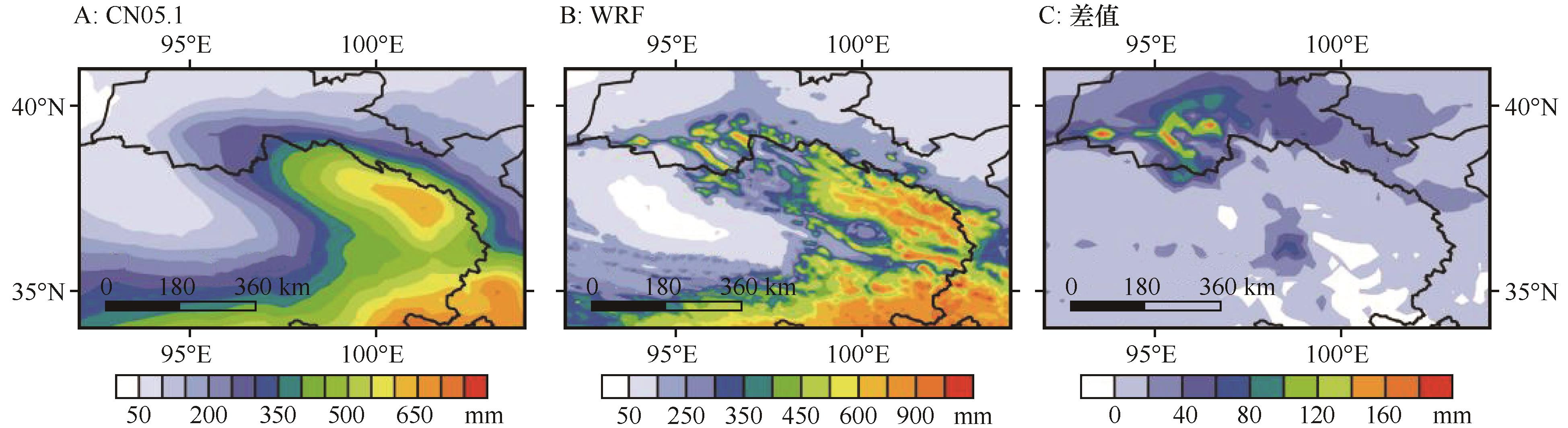
Fig.6 Spatial distribution of observed (A) and simulated (B) mean annual precipitation and the difference between the two (C) for 2005-2014
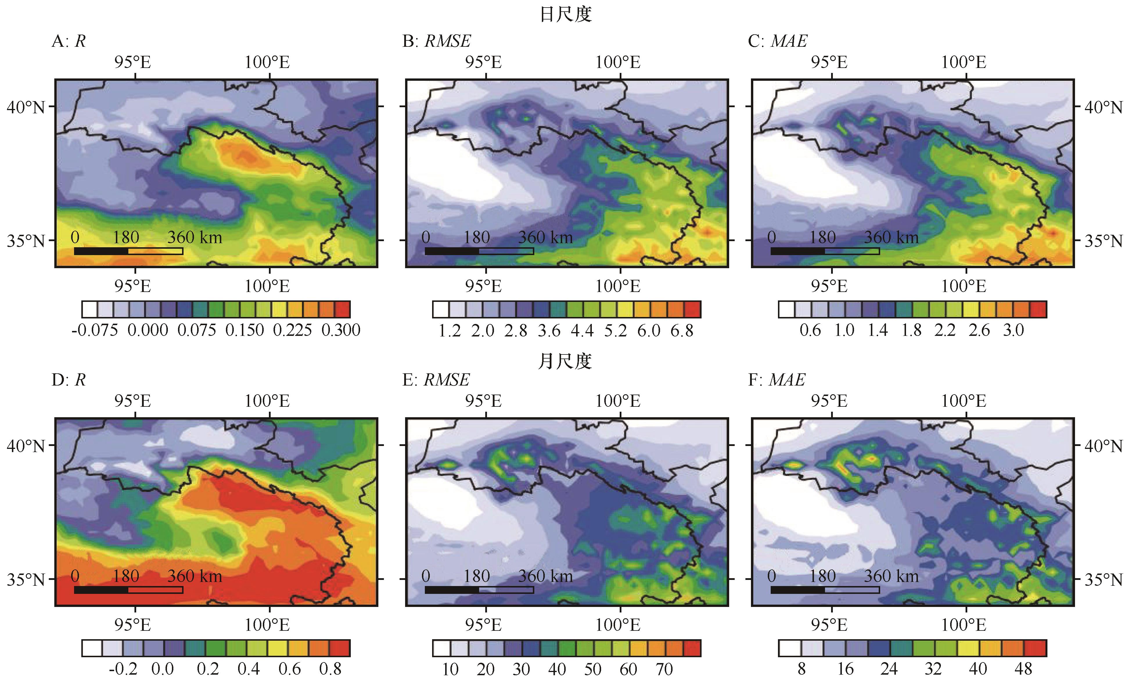
Fig.7 Spatial distribution of daily (A, B, C) and monthly (D, E, F) scale precipitation spatial correlation coefficients, root mean square errors and absolute deviations
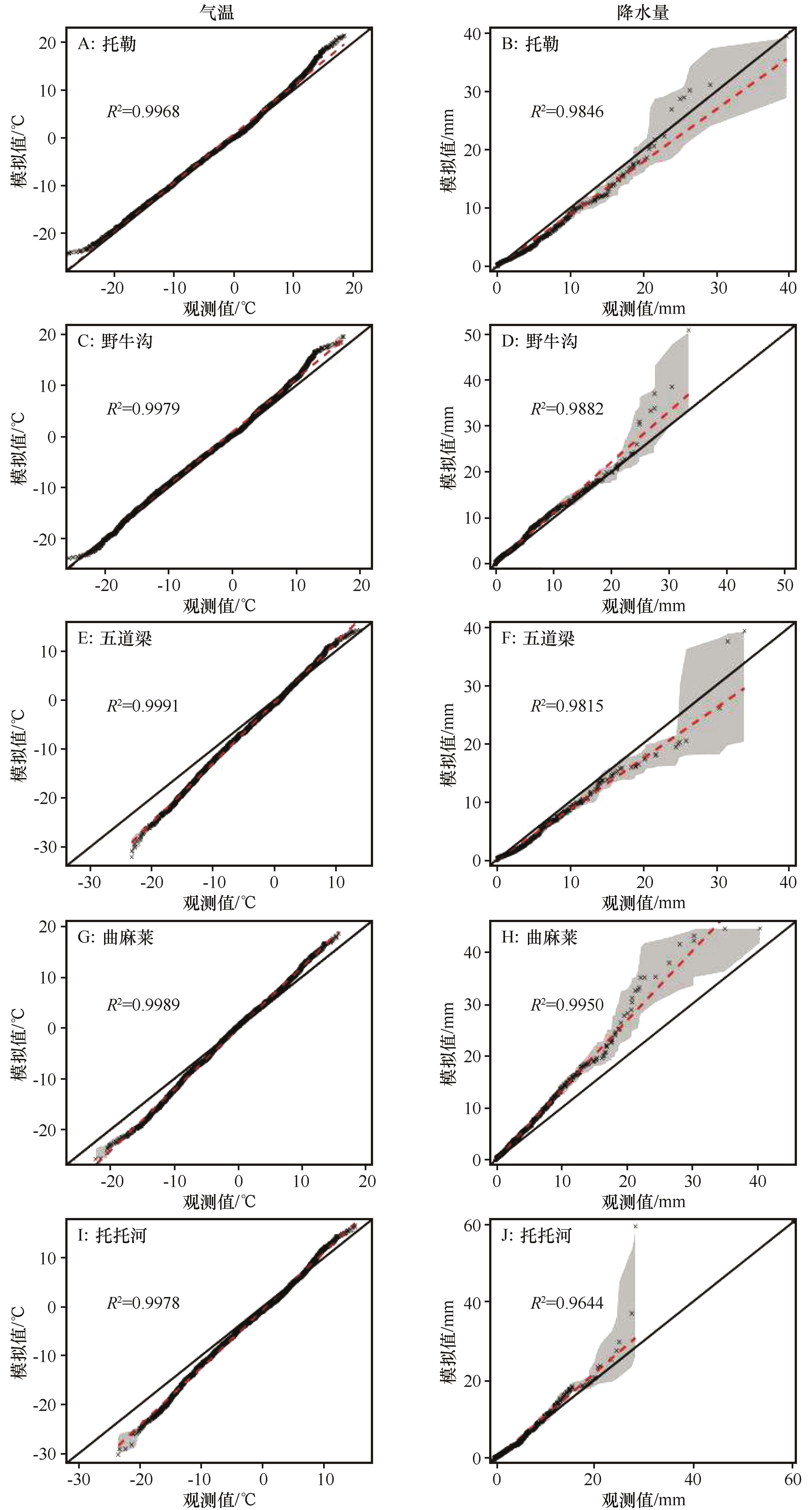
Fig.8 Quantile-Quantile plots of temperature (left) and precipitation (right) at five sites (Gray shaded region indicates 90% confidence intervals)
| 1 | Xu Z X, Rhoades A M, Johansen H,et al.An intercomparison of GCM and RCM dynamical downscaling for characterizing the hydroclimatology of California and Nevada[J].Journal of Hydrometeorology,2018,19(9):1485-1506. |
| 2 | Corte-Real J, Zhang X B, Wang X L.Downscaling GCM information to regional scales:a non-parametric multivariate regression approach[J].Climate Dynamics,1995,11:413-424. |
| 3 | Lin C G, Chen D L, Yang K,et al.Impact of model resolution on simulating the water vapor transport through the central Himalayas:implication for models' wet bias over the Tibetan Plateau[J].Climate Dynamics,2018,51:3195-3207. |
| 4 | 许建伟,高艳红.WRF模式对夏季黑河流域气温和降水的模拟及检验[J].高原气象,2014,33(4):937-946. |
| 5 | Srinivas C V, Hariprasad D, Rao D V B,et al.Simulation of the Indian summer monsoon regional climate using advanced research WRF model[J].International Journal of Climatology,2013,33(5):1195-1210. |
| 6 | Gao Z B, Yan X D, Dong S Y,et al.Object-based evaluation of rainfall forecasts over eastern China by eight cumulus parameterization schemes in the WRF Model[J].Atmospheric Research,2023:106618. |
| 7 | Wang Y L, Feng J M, Luo M,et al.Uncertainties in simulating central Asia:sensitivity to physical parameterizations using Weather Research and Forecasting model[J].International Journal of Climatology,2020,40(14):5813-5828. |
| 8 | Pérez J C, Díaz J P, González A,et al.Evaluation of WRF parameterizations for dynamical downscaling in the Canary Islands[J].Journal of Climate,2014,27(14):5611-5631. |
| 9 | Argüeso D, Hidalgo-Muñoz J M, Gámiz-Fortis S R,et al.Evaluation of WRF parameterizations for climate studies over southern Spain using a multistep regionalization[J].Journal of Climate,2011,24(21):5633-5651. |
| 10 | Gou D L, Sun J Q, Yu E T.Evaluation of CORDEX regional climate models in simulating temperature and precipitation over the Tibetan Plateau[J].Atmospheric and Oceanic Science Letters,2018,11(3):219-227. |
| 11 | Wang X J, Pang G J, Yang M X.Precipitation over the Tibetan Plateau during recent decades:a review based on observations and simulations[J].International Journal of Climatology,2018,38(3):1116-1131. |
| 12 | 韩林君,白爱娟,蒲学敏.基于CMIP6的祁连山气候变化特征预估[J].高原气象,2022,41(4):864-875. |
| 13 | 任婧,张文煜,黄颖,等.祁连山区再分析降水数据的适用性分析[J].兰州大学学报(自然科学版),2023,59(1):23-28. |
| 14 | Gallus W A, Bresch J F.Comparison of impacts of WRF dynamic core,physics package,and initial conditions on warm season rainfall forecasts[J].Monthly Weather Review,2006,134(9):2632-2641. |
| 15 | Jankov I, Gallus Jr W A, Segal M,et al.Influence of initial conditions on the WRF-ARW model QPF response to physical parameterization changes[J].Weather and Forecasting,2007,22(3):501-519. |
| 16 | Crétat J, Pohl B, Richard Y,et al.Uncertainties in simulating regional climate of Southern Africa:sensitivity to physical parameterizations using WRF[J].Climate Dynamics,2012,38:613-634. |
| 17 | Varga Á J, Breuer H.Sensitivity of simulated temperature,precipitation,and global radiation to different WRF configurations over the Carpathian Basin for regional climate applications[J].Climate Dynamics,2020,55(9/10):2849-2866. |
| 18 | 尹金方,王东海,翟国庆.区域中尺度模式云微物理参数化方案特征及其在中国的适用性[J].地球科学进展,2014,29(2):238-242. |
| 19 | 张文煜,任婧,付丹红,等.祁连山一次降水过程云模式模拟参数的选择及微物理结构特征分析[J].干旱区研究,2022,39(6):1717-1727. |
| 20 | 于伟,彭杨,姚礼双,等.WRF模式不同参数化方案对长江上游降雨模拟的影响[J/OL].中国农村水利水电:1-15[2023-03-12].. |
| 21 | 张宝庆,田磊,赵西宁,等.植被恢复对黄土高原局地降水的反馈效应研究[J].中国科学:地球科学,2021,51(7):1080-1091. |
| 22 | Navale A, Singh C, Budakoti S,et al.Evaluation of season long rainfall simulated by WRF over the NWH region:KF vs.MSKF[J].Atmospheric Research,2020,232:104682. |
| 23 | Liu Y, Chen X, Li Q,et al.Impact of different microphysics and cumulus parameterizations in WRF for heavy rainfall simulations in the central segment of the Tianshan Mountains,China[J].Atmospheric Research,2020,244:105052. |
| 24 | Gao S B, Huang D L, Du N Z,et al.WRF ensemble dynamical downscaling of precipitation over China using different cumulus convective schemes[J].Atmospheric Research,2022,271:106116. |
| 25 | Lv M Z, Xu Z F, Yang Z L.Cloud resolving WRF simulations of precipitation and soil moisture over the central Tibetan Plateau:an assessment of various physics options[J].Earth and Space Science,2020,7(2):e2019EA000865. |
| 26 | 周志敏,崔春光,胡扬,等.一次梅雨锋暴雨过程数值模拟的云微物理参数化敏感性研究[J].大气科学,2021,45(6):1292-1312. |
| 27 | 童颖睿,闵锦忠.云微物理方案参数扰动对华北“7.20”暴雨的集合预报试验[J].气象科学,2022,42(2):213-224. |
| 28 | 刘东海,黄静,刘娟,等.国内外典型中尺度数值预报模式参数化方案的综述与展望[J].地球科学进展,2023,38(4):349-362. |
| 29 | 徐娟娟,王可丽,江灏,等.西风与季风扰动对黑河流域降水影响的数值模拟[J].冰川冻土,2010,32(3):489-496. |
| 30 | 宁贵财,尚可政,王式功,等.贺兰山对银川一次致灾暴雨过程影响的数值模拟[J].中国沙漠,2015,35(2):464-473. |
| 31 | 肖林鸿,高艳红, Chen Fei,等.青藏高原极端气温的动力降尺度模拟[J].高原气象,2016,35(3):574-589. |
| 32 | Yang J H, Duan K Q.Effects of initial drivers and land use on WRF modeling for near-surface fields and atmospheric boundary layer over the northeastern Tibetan Plateau[J].Advances in Meteorology,2016(2016):1-16. |
| 33 | Zhang X Z, Xiong Z, Zheng J Y,et al.High-resolution precipitation data derived from dynamical downscaling using the WRF model for the Heihe River Basin,northwest China[J].Theoretical and Applied Climatology,2018,131:1249-1259. |
| 34 | Iacono M J, Delamere J S, Mlawer E J,et al.Radiative forcing by long‐lived greenhouse gases:calculations with the AER radiative transfer models[J].Journal of Geophysical Research:Atmospheres,2008,113(D13):D13103. |
| 35 | 徐蓉蓉,梁信忠,段明铿.CWRF对青藏高原气温和降水模拟效果的综合评估[J].大气科学学报,2021,44(1):104-117. |
| 36 | Gao Y H, Chen F, Miguez-Macho G,et al.Understanding precipitation recycling over the Tibetan Plateau using tracer analysis with WRF[J].Climate Dynamics,2020,55:2921-2937. |
| 37 | Qian X, Yao Y Q, Wang H S,et al.Validation of the WRF model for estimating precipitable water vapor at the Ali Observatory on the Tibetan Plateau[J].Publications of the Astronomical Society of the Pacific,2020,132(1018):125003. |
| 38 | Dai Y F, Wang L, Yao T D,et al.Observed and simulated lake effect precipitation over the Tibetan Plateau:an initial study at Nam Co Lake[J].Journal of Geophysical Research:Atmospheres,2018,123(13):6746-6759. |
| 39 | 智协飞,吴佩,俞剑蔚,等.GFS模式地形高度偏差对地面2 m气温预报的影响[J].大气科学学报,2019,42(5):652-659. |
| 40 | 于晓晶,赵勇.地形对天山夏季降水影响的模拟[J].中国沙漠,2016,36(4):1133-1143. |
| 41 | Castro C L, Pielke Sr R A, Leoncini G.Dynamical downscaling:assessment of value retained and added using the Regional Atmospheric Modeling System (RAMS)[J].Journal of Geophysical Research:Atmospheres,2005,110(D5). |
| 42 | Lo J C F, Yang Z L, Pielke Sr R A.Assessment of three dynamical climate downscaling methods using the Weather Research and Forecasting(WRF)model[J].Journal of Geophysical Research:Atmospheres,2008,113(D9):D09112. |
| 43 | García-Díez M, Fernández J, Vautard R.An RCM multi-physics ensemble over Europe:multi-variable evaluation to avoid error compensation[J].Climate Dynamics,2015,45(11/12):3141-3156. |
| 44 | Hahmann A N, Vincent C L, Peña A,et al. Wind climate estimation using WRF model output:method and model sensitivities over the sea[J].International Journal of Climatology, 2015,35(12):3422-3439. |
| 45 | Hong S Y, Lim J O J.The WRF single-moment 6-class microphysics scheme (WSM6)[J].Asia-Pacific Journal of Atmospheric Sciences,2006,42(2):129-151. |
| 46 | Thompson G, Field P R, Rasmussen R M,et al.Explicit forecasts of winter precipitation using an improved bulk microphysics scheme.Part II:implementation of a new snow parameterization[J].Monthly Weather Review,2008,136(12):5095-5115. |
| 47 | Kain J S.The Kain-Fritsch convective parameterization:an update[J].Journal of Applied Meteorology,2004,43(1):170-181. |
| 48 | Grell G A, Dévényi D.A generalized approach to parameterizing convection combining ensemble and data assimilation techniques[J].Geophysical Research Letters,2002,29(14):381-384. |
| 49 | Mlawer E J, Taubman S J, Brown P D,et al.Radiative transfer for inhomogeneous atmospheres:RRTM,a validated correlated‐k model for the longwave[J].Journal of Geophysical Research:Atmospheres,1997,102(D14):16663-16682. |
| 50 | Dudhia J.Numerical study of convection observed during the winter monsoon experiment using a mesoscale two-dimensional model[J].Journal of Atmospheric Sciences,1989,46(20):3077-3107. |
| 51 | Collins W D, Rasch P J, Boville B A,et al.Description of the NCAR community atmosphere model (CAM 3.0)[J].NCAR Technical Note,2004,226:1326-1334. |
| 52 | Chen F, Dudhia J.Coupling an advanced land surface-hydrology model with the Penn State-NCAR MM5 modeling system.Part I:model implementation and sensitivity[J].Monthly Weather Review,2001,129(4):569-585. |
| 53 | Hong S Y, Noh Y, Dudhia J.A new vertical diffusion package with an explicit treatment of entrainment processes[J].Monthly Weather Review,2006,134(9):2318-2341. |
| 54 | Stauffer D R, Seaman N L.Use of four-dimensional data assimilation in a limited-area mesoscale model.Part I:experiments with synoptic-scale data[J].Monthly Weather Review,1990,118(6):1250-1277. |
| 55 | Kalnay E, Kanamitsu M, Kistler R,et al.The NCEP/NCAR 40-year reanalysis project[J].Bulletin of the American Meteorological Society,1996,77(3):437-472. |
| 56 | Berrisford P, Dee D, Fielding K,et al.The ERA-interim archive[J].ERA Report Series,2009(1):1-16. |
| 57 | Xu Z F, Han Y, Tam C Y,et al.Bias-corrected CMIP6 global dataset for dynamical downscaling of the historical and future climate (1979-2100)[J].Scientific Data,2021,8(1):293. |
| 58 | 胡芩,姜大膀,范广洲.CMIP5全球气候模式对青藏高原地区气候模拟能力评估[J].大气科学,2014,38(5):924-938. |
| 59 | Wu J, Gao X J, Giorgi F,et al.Changes of effective temperature and cold/hot days in late decades over China based on a high resolution gridded observation dataset[J].International Journal of Climatology,2017,37:788-800. |
| 60 | Taylor K E.Summarizing multiple aspects of model performance in a single diagram[J].Journal of Geophysical Research:Atmospheres,2001,106(D7):7183-7192. |
| 61 | White S M, Ravelo A C, Polissar P J.Dampened El Niño in the early and mid‐Holocene due to insolation‐forced warming/deepening of the thermocline[J].Geophysical Research Letters,2018,45(1):316-326. |
| 62 | Meng X, Lyu S, Zhang T,et al.Simulated cold bias being improved by using MODIS time-varying albedo in the Tibetan Plateau in WRF model[J].Environmental Research Letters,2018,13(4):044028. |
| 63 | Huang D, Gao S B.Impact of different cumulus convective parameterization schemes on the simulation of precipitation over China[J].Tellus A:Dynamic Meteorology and Oceanography,2017,69(1):1406264. |
| 64 | Yue S Y, Yang K, Lu H,et al.Representation of stony surface‐atmosphere interactions in WRF reduces cold and wet biases for the southern Tibetan Plateau[J].Journal of Geophysical Research:Atmospheres,2021,126(21):e2021JD035291. |
| 65 | Yan D D, Liu T Y, Dong W J,et al.Integrating remote sensing data with WRF model for improved 2-m temperature and humidity simulations in China[J].Dynamics of Atmospheres and Oceans,2020,89:101127. |
| 66 | Gao Y H, Xu J, Chen D.Evaluation of WRF mesoscale climate simulations over the Tibetan Plateau during 1979-2011[J].Journal of Climate,2015,28(7):2823-2841. |
| 67 | Gao Y H, Chen F, Jiang Y.Evaluation of a convection-permitting modeling of precipitation over the Tibetan Plateau and its influences on the simulation of snow-cover fraction[J].Journal of Hydrometeorology,2020,21(7):1531-1548. |
| 68 | Ji Z M, Kang S C.Double-nested dynamical downscaling experiments over the Tibetan Plateau and their projection of climate change under two RCP scenarios[J].Journal of the Atmospheric Sciences,2013,70(4):1278-1290. |
| 69 | Li P X, Furtado K, Zhou T J,et al.Convection‐permitting modelling improves simulated precipitation over the central and eastern Tibetan Plateau[J].Quarterly Journal of the Royal Meteorological Society,2021,147(734):341-362. |
| [1] | Zhulei Dong, Xuegong Jiang, Nana Yi, Zhili Xu, Yuehe Hang, Shuiyan Yu. Numerical simulation of the influence of wind speed and vegetation on dust weather in Inner Mongolia, China [J]. Journal of Desert Research, 2023, 43(6): 29-39. |
| [2] | Siyu Chen, Yawen Guan, Dan Zhao, Gaotong Lou, Yu Chen. Influence of dust aerosol on land surface diurnal temperature range over East Asia Simulated with the WRF-Chem model [J]. Journal of Desert Research, 2022, 42(3): 127-138. |
| [3] | Yi Nana, Jiang Xuegong, Dong Zhulei, Yu Shuiyan, Kang Shengwei. Numerical simulation of a dust process in Inner Mongolia of China [J]. Journal of Desert Research, 2020, 40(3): 115-126. |
| [4] | Kang Litai, Chen Siyu. Numerical Modeling of a Dust Storm Process in Northern China [J]. JOURNAL OF DESERT RESEARCH, 2017, 37(2): 321-331. |
| [5] | WANG Cheng-hai, HU Ju, JIN Shuang-long. The Vapor Characteristics in a Dust Storm and Verification of WRF Hindcast [J]. JOURNAL OF DESERT RESEARCH, 2013, 33(1): 205-213. |
| [6] | ZHU Wei-jun, LIAO Zhi-yi, HE Qing, MIAO Qi-long. Numerical Simulation of Rainstorm in Tianshan Mountains Area [J]. JOURNAL OF DESERT RESEARCH, 2012, 32(4): 1102-1109. |
| [7] | WANG Cheng-hai;JIN Shuang-long;YANG Shi-li. Simulation and Analysis of the Thermal-dynamics Characteristics of [J]. JOURNAL OF DESERT RESEARCH, 2011, 31(2): 511-516. |
| Viewed | ||||||
|
Full text |
|
|||||
|
Abstract |
|
|||||
©2018Journal of Desert Research
Tel:0931-8267545
Email:caiedit@lzb.ac.cn;desert@lzb.ac.cn
Support:Magtech