
- CN 62-1070/P
- ISSN 1000-694X
- Bimonthly 1981
Journal of Desert Research ›› 2023, Vol. 43 ›› Issue (6): 60-70.DOI: 10.7522/j.issn.1000-694X.2023.00072
Previous Articles Next Articles
Ruijie Lu1,2( ), Shulin Liu1(), Wenping Kang1, Kun Feng1, Zichen Guo1, Ying Zhi1,2
Received:2023-03-23
Revised:2023-05-31
Online:2023-11-20
Published:2023-11-30
Contact:
Shulin Liu
CLC Number:
Ruijie Lu, Shulin Liu, Wenping Kang, Kun Feng, Zichen Guo, Ying Zhi. Combining the GEE platform and machine learning algorithm for desert information extraction[J]. Journal of Desert Research, 2023, 43(6): 60-70.
Add to citation manager EndNote|Ris|BibTeX
URL: http://www.desert.ac.cn/EN/10.7522/j.issn.1000-694X.2023.00072
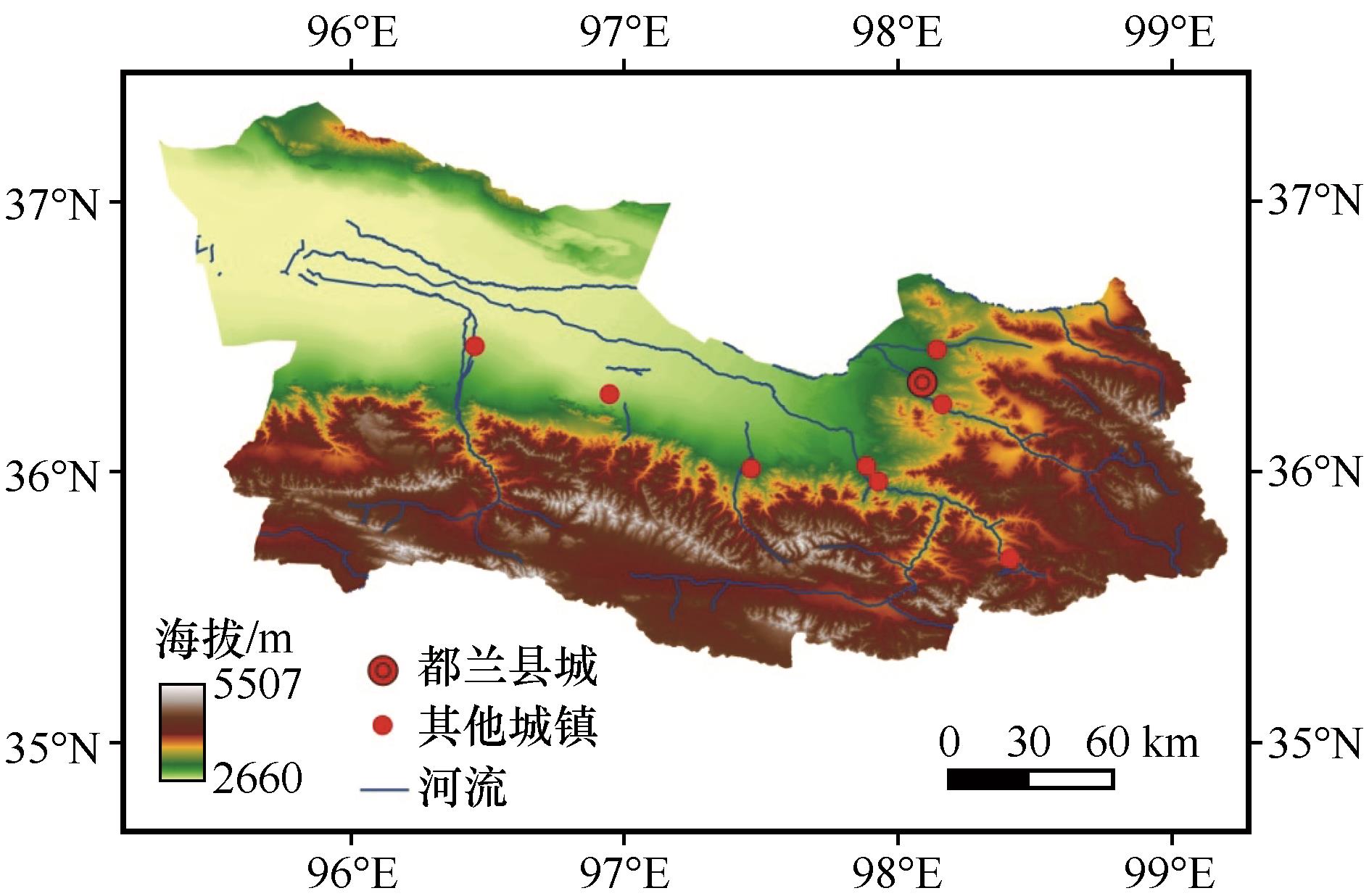
Fig.1 Location and geographical overview of the study area
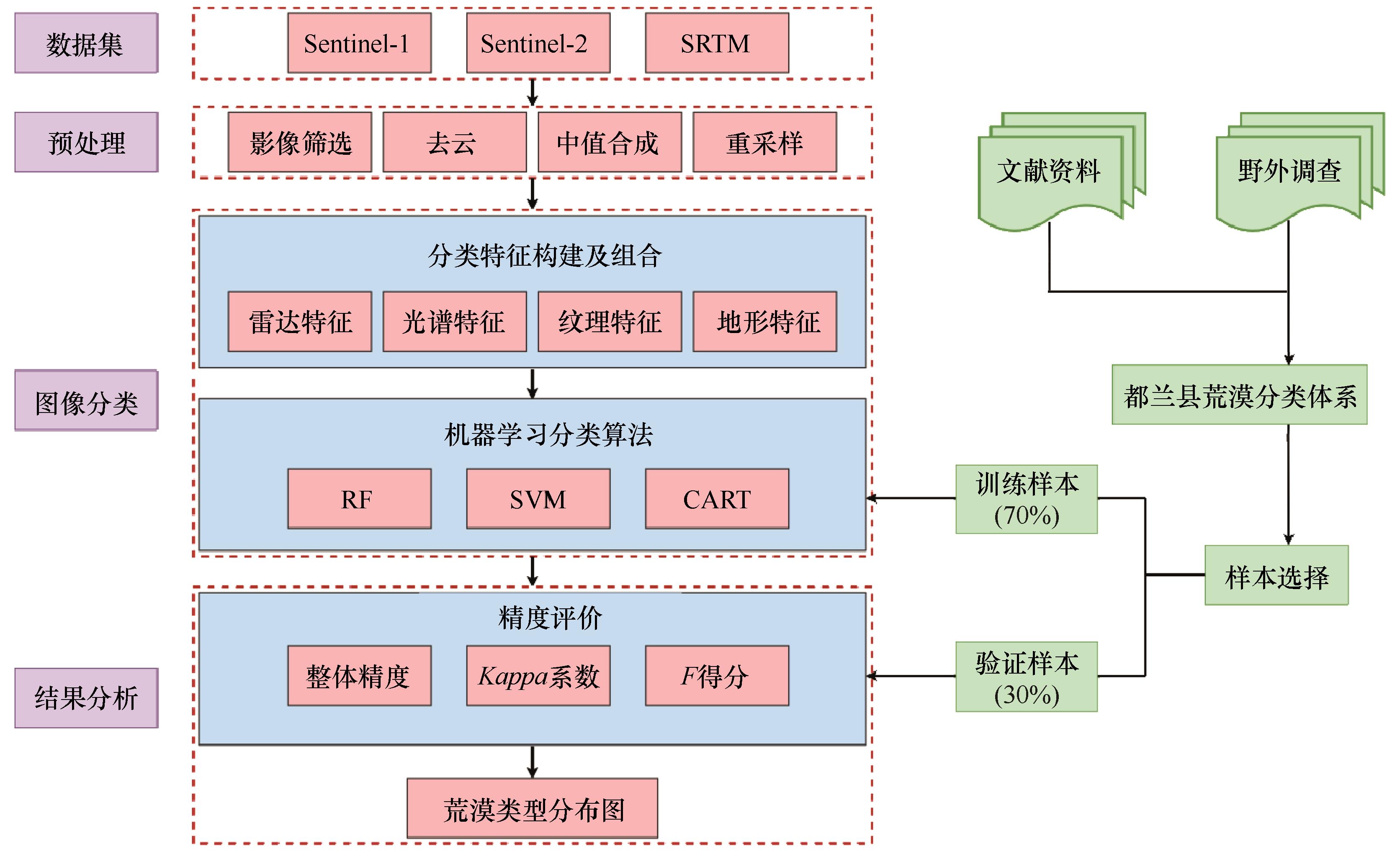
Fig.2 Technical flow chart of desert classification
| 类型 | 缩写 | 地表特征描述 | Sentinel-2影像特征 |
|---|---|---|---|
| 沙质荒漠 | SD | 地表被沙子覆盖,主要包括平缓积沙地和沙丘区 |  |
| 砾质荒漠 | GD | 地表被砾石覆盖,地势平坦,主要为各种砾石含量较高的冲洪积平原和风蚀戈壁 |  |
| 轻度盐碱荒漠 | MS | 表土盐碱含量较高,颜色偏白 |  |
| 重度盐碱荒漠 | SS | 地表盐碱聚集,土壤板结现象严重,颜色偏黑 | 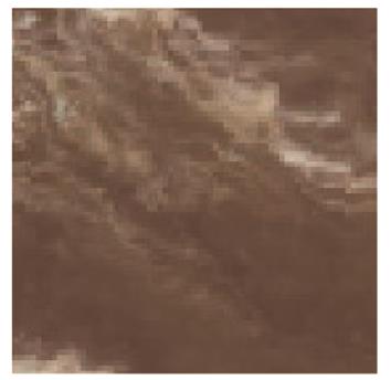 |
| 壤土荒漠 | LD | 地表土质覆盖,颜色偏黄 |  |
| 岩石荒漠 | RD | 地表主要为岩石,土壤发育较差,地势崎岖,分布在山区 | 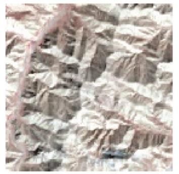 |
| 高山寒漠 | AC | 相较于岩石荒漠海拔更高,主要分布于雪线以下、植被线以上,通常颜色为黑色或黑褐色 | 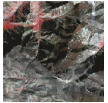 |
Table 1 Desert classification system of Dulan County
| 类型 | 缩写 | 地表特征描述 | Sentinel-2影像特征 |
|---|---|---|---|
| 沙质荒漠 | SD | 地表被沙子覆盖,主要包括平缓积沙地和沙丘区 | |
| 砾质荒漠 | GD | 地表被砾石覆盖,地势平坦,主要为各种砾石含量较高的冲洪积平原和风蚀戈壁 | |
| 轻度盐碱荒漠 | MS | 表土盐碱含量较高,颜色偏白 | |
| 重度盐碱荒漠 | SS | 地表盐碱聚集,土壤板结现象严重,颜色偏黑 | |
| 壤土荒漠 | LD | 地表土质覆盖,颜色偏黄 | |
| 岩石荒漠 | RD | 地表主要为岩石,土壤发育较差,地势崎岖,分布在山区 | |
| 高山寒漠 | AC | 相较于岩石荒漠海拔更高,主要分布于雪线以下、植被线以上,通常颜色为黑色或黑褐色 | |
| CF组合 | 光谱波段 | 光谱指数 | 雷达特征 | 地形特征 | 纹理特征 |
|---|---|---|---|---|---|
| CF1 | √ | √ | |||
| CF2 | √ | √ | √ | ||
| CF3 | √ | √ | √ | ||
| CF4 | √ | √ | √ | ||
| CF5 | √ | √ | √ | √ | √ |
Table 2 Classification features contained in different combinations of feature variables
| CF组合 | 光谱波段 | 光谱指数 | 雷达特征 | 地形特征 | 纹理特征 |
|---|---|---|---|---|---|
| CF1 | √ | √ | |||
| CF2 | √ | √ | √ | ||
| CF3 | √ | √ | √ | ||
| CF4 | √ | √ | √ | ||
| CF5 | √ | √ | √ | √ | √ |
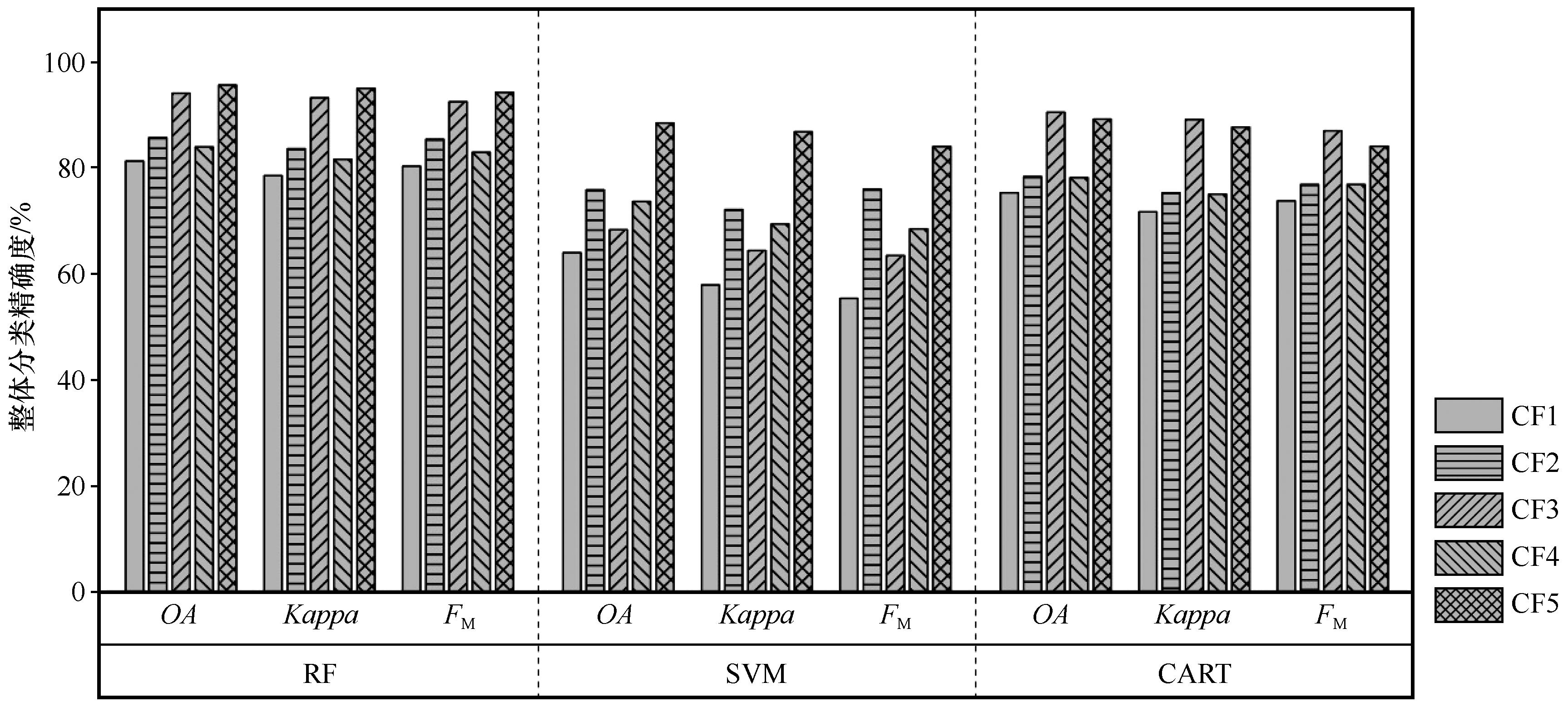
Fig.3 Overall accuracy of RF, SVM, and CART with different classification feature combinations
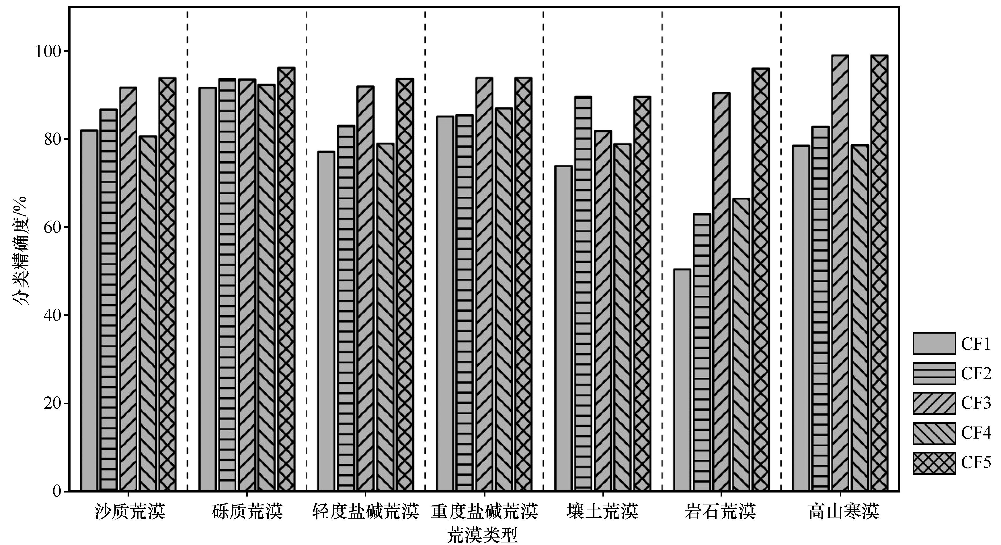
Fig.4 Classification accuracy of each desert type under different combinations of classification features
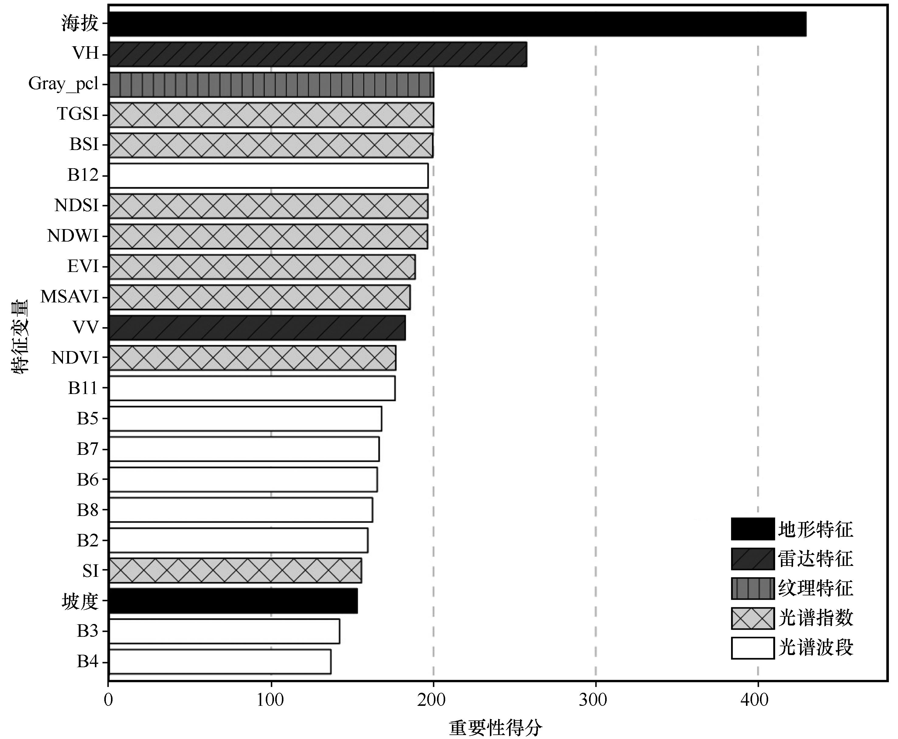
Fig.5 Importance scores of feature variables
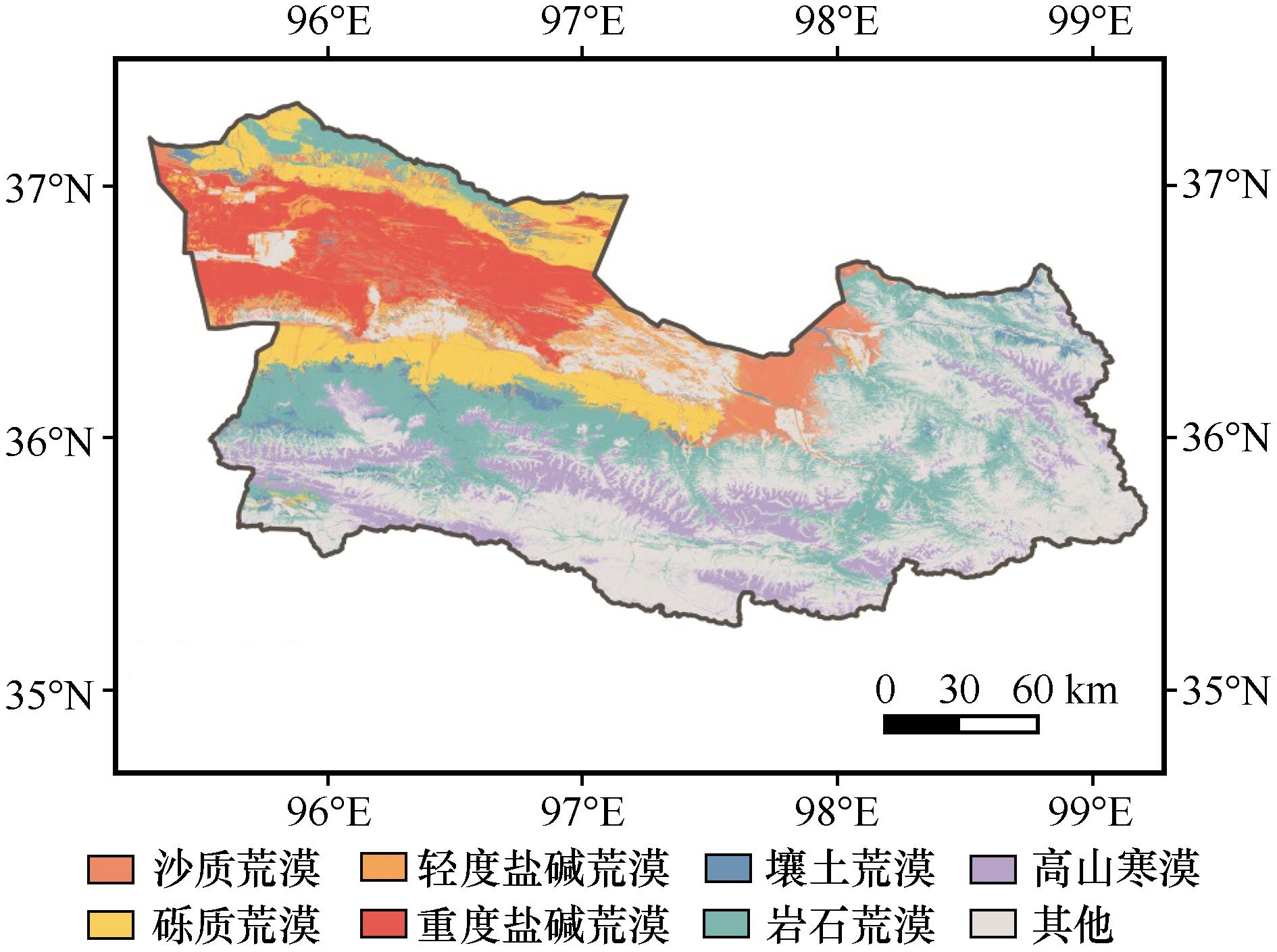
Fig.6 Spatial distribution of desert types in Dulan County
| 1 | Li C, Fu B, Wang S,et al.Drivers and impacts of changes in China's drylands[J].Nature Reviews Earth & Environment,2021,2(12):858-873. |
| 2 | 程磊磊,郭浩,卢琦.荒漠生态系统服务价值评估研究进展[J].中国沙漠,2013,33(1):281-287. |
| 3 | Huang J, Zhang G, Zhang Y,et al.Global desertification vulnerability to climate change and human activities[J].Land Degradation & Development,2020,31(11):1380-1391. |
| 4 | 杨发相,桂东伟,岳健,等.干旱区荒漠分类系统探讨:以新疆为例[J].干旱区资源与环境,2015,29(11):145-151. |
| 5 | 王涛,朱震达.我国沙漠化研究的若干问题:1.沙漠化的概念及其内涵[J].中国沙漠,2003,23(3):3-8. |
| 6 | Liu L, Zhang X, Gao Y,et al.Finer-resolution mapping of global land cover:recent developments,consistency analysis,and prospects[J].Journal of Remote Sensing,2021(1):1-38. |
| 7 | Zhang M, Ma M, De Maeyer P,et al.Uncertainties in classification system conversion and an analysis of inconsistencies in global land cover products[J].ISPRS International Journal of Geo-Information,2017,6(4):112. |
| 8 | 许晓聪,李冰洁,刘小平,等.全球2000-2015年30 m分辨率逐年土地覆盖制图[J].遥感学报,2021,25(9):1896-1916. |
| 9 | 姚爱冬,车腾腾,姜丽娜,等.甘肃民勤县荒漠化区未利用地的遥感分类研究[J].林业科学研究,2014,27(2):195-200. |
| 10 | 杨发相,李生宇,岳健,等.新疆荒漠类型特征及其保护利用[J].干旱区地理,2019,42(1):12-19. |
| 11 | 肖森天,依力亚斯江·努尔麦麦提,努尔比耶·穆合塔尔,等.基于光学和雷达多源遥感的于田绿洲土壤盐渍化时空分析[J].干旱区研究,2023,40(1):59-68. |
| 12 | Zhang J.Multi-source remote sensing data fusion:status and trends[J].International Journal of Image and Data Fusion,2010,1(1):5-24. |
| 13 | Joshi N, Baumann M, Ehammer A,et al.A review of the application of optical and radar remote sensing data fusion to land use mapping and monitoring[J].Remote Sensing,2016,8(1):70. |
| 14 | Halmy M W A, Gessler P E.The application of ensemble techniques for land-cover classification in arid lands[J].International Journal of Remote Sensing,2015,36(22):5613-5636. |
| 15 | Phan T N, Kuch V, Lehnert L W.Land cover classification using Google Earth Engine and random forest classifier:the role of image composition[J].Remote Sensing,2020,12:2411. |
| 16 | Gorelick N, Hancher M, Dixon M,et al.Google Earth Engine:Planetary-scale geospatial analysis for everyone[J].Remote Sensing of Environment,2017,202:18-27. |
| 17 | 张华,安慧敏.基于GEE的1987-2019年民勤绿洲NDVI变化特征及趋势分析[J].中国沙漠,2021,41(1):28-36. |
| 18 | Wang L, Diao C, Xian G,et al.A summary of the special issue on remote sensing of land change science with Google Earth Engine[J].Remote Sensing of Environment,2020,248:112002. |
| 19 | Yang X, Zhang K, Jia B,et al.Desertification assessment in China:an overview[J].Journal of Arid Environments,2005,63(2):517-531. |
| 20 | 鲍锋,董治宝,张正偲.柴达木盆地风沙地貌区风况特征[J].中国沙漠,2015,35(3):549-554. |
| 21 | Han J, Wang J, Chen L,et al.Driving factors of desertification in Qaidam Basin,China:an 18-year analysis using the geographic detector model[J].Ecological Indicators,2021,124:107404. |
| 22 | Fu Y, Chen H, Niu H,et al.Spatial and temporal variation of vegetation phenology and its response to climate changes in Qaidam Basin from 2000 to 2015[J].Journal of Geographical Sciences,2018,28:400-414. |
| 23 | 俞孔坚,李海龙,李迪华,等.国土尺度生态安全格局[J].生态学报,2009,29(10):5163-5175. |
| 24 | 王晓峰,勒斯木初,张明明.“两屏三带”生态系统格局变化及其影响因素[J].生态学杂志,2019,38(7):2138-2148. |
| 25 | Filipponi F.Sentinel-1 GRD preprocessing workflow[C]//Proceedings of the International Electronic Conference on Remote Sensing,2019:11. |
| 26 | Van Zyl J J.The Shuttle Radar Topography Mission (SRTM):a breakthrough in remote sensing of topography[J].Acta Astronautica,2001,48(5):559-565. |
| 27 | 刘纪远.中国资源环境遥感宏观调查与动态[M].北京:中国科学技术出版社,1996. |
| 28 | 刘亚群,吕昌河,傅伯杰,等.中国陆地生态系统分类识别及其近20年的时空变化[J].生态学报,2021,41(10):3975-3987. |
| 29 | 赵欣悦,席海洋,赵静,等.阿拉善地区土壤盐渍化的遥感反演及分布特征[J].中国沙漠,2023,43(1):27-36. |
| 30 | Kupidura P.The comparison of different methods of texture analysis for their efficacy for land use classification in satellite imagery[J].Remote Sensing,2019,11(10):1233. |
| 31 | Haralick R M, Shanmugam K, Dinstein I H.Textural features for image classification[J].IEEE Transactions on Systems,Man,and Cybernetics,1973,SMC(6):610-621. |
| 32 | Tassi A, Vizzari M.Object-oriented lulc classification in Google Earth Engine combining SNIC,GLCM,and machine learning algorithms[J].Remote Sensing,2020,12(22):3776. |
| 33 | Breiman L.Random forests[J].Machine Learning,2001,45:5-32. |
| 34 | Miao X, Heaton J S.A comparison of random forest and Adaboost tree in ecosystem classification in east Mojave Desert[C]//Proceedings of the 2010 18th International Conference on Geoinformatics.Beijing,China,2010:1-6. |
| 35 | Huang C, Davis L S, Townshend J R G.An assessment of support vector machines for land cover classification[J].International Journal of Remote Sensing,2002,23(4):725-749. |
| 36 | Foody G M, Mathur A.A relative evaluation of multiclass image classification by support vector machines[J].IEEE Transactions on Geoscience and Remote Sensing,2004,42(6):1335-1343. |
| 37 | Shetty S.Analysis of machine learning classifiers for LULC classification on Google Earth Engine[D].Enschede,Netherlands:University of Twente,2019. |
| 38 | Sokolova M, Japkowicz N, Szpakowicz S.Beyond accuracy,F-score and ROC:a family of discriminant measures for performance evaluation[C]//Proceedings of the AI 2006:Advances in Artificial Intelligence:19th Australian Joint Conference on Artificial Intelligence.Hobart,Australia,2006:1015-1021. |
| 39 | Maxwell A E, Warner T A, Fang F.Implementation of machine-learning classification in remote sensing:an applied review[J].International Journal of Remote Sensing,2018,39(9):2784-2817. |
| 40 | Abida K, Barbouchi M, Boudabbous K,et al.Sentinel-2 data for land use mapping:comparing different supervised classifications in semi-arid areas[J].Agriculture,2022,12(9):1429. |
| 41 | Mustak S, Uday G, Ramesh B,et al.Evaluation of the performance of SAR and SAR-optical fused dataset for crop discrimination[C]//Workshop on "Earth Observations for Agricultural Monitoring",The International Archives of the Photogrammetry,Remote Sensing and Spatial Information Sciences.New Delhi,India,2019:563-571. |
| 42 | Shih H, Stow D A, Tsai Y H.Guidance on and comparison of machine learning classifiers for Landsat-based land cover and land use mapping[J].International Journal of Remote Sensing,2019,40(4):1248-1274. |
| 43 | 张亦然,刘廷玺,童新,等.基于多源遥感和机器学习方法的科尔沁沙地植被覆盖度反演[J].中国沙漠,2022,42(3):187-195. |
| 44 | 任雨,张勃,陈曦东.科尔沁沙地土地荒漠化敏感性评估[J].中国沙漠,2023,43(2):159-169. |
| 45 | Wu W.The generalized difference vegetation index (GDVI) for dryland characterization[J].Remote Sensing,2014,6(2):1211-1233. |
| 46 | Xiao J, Shen Y, Tateishi R,et al.Development of topsoil grain size index for monitoring desertification in arid land using remote sensing[J].International Journal of Remote Sensing,2006,27(12):2411-2422. |
| 47 | Zhou H, Fu L, Sharma R P,et al.A hybrid approach of combining random forest with texture analysis and VDVI for desert vegetation mapping based on UAV RGB Data[J].Remote Sensing,2021,13(10):1891. |
| 48 | 张志伟,尹惠妍,钱登峰,等.高寒地区荒漠分类系统初探:以堆龙德庆区为例[J].高原农业,2019,3(1):47-53. |
| 49 | Song Y, Zheng H, Chen X,et al.Desertification extraction based on a microwave backscattering contribution decomposition model at the dry bottom of the Aral Sea[J].Remote Sensing,2021,13(23):4850. |
| 50 | Blaschke T.Object based image analysis for remote sensing[J].ISPRS Journal of Photogrammetry and Remote Sensing,2010,65(1):2-16. |
| 51 | Chen G, Weng Q, Hay G J,et al.Geographic object-based image analysis (GEOBIA):emerging trends and future opportunities[J].GIScience & Remote Sensing,2018,55(2):159-182. |
| 52 | Liu D, Xia F.Assessing object-based classification:advantages and limitations[J].Remote Sensing Letters,2010,1(4):187-194. |
| [1] | Yiran Zhang, Tingxi Liu, Xin Tong, Limin Duan, Tianyu Jia, Yaxin Ji. Inversion of vegetation coverage based on multi-source remote sensing data and machine learning method in the Horqin Sandy Land, China [J]. Journal of Desert Research, 2022, 42(3): 187-195. |
| [2] | Yulai Gong, Shaoxiu Ma, Weiqi Liu. A comparative study of machine learning and statistical models in climate downscaling in the Shiyang River Basin [J]. Journal of Desert Research, 2022, 42(1): 196-210. |
| [3] | Haowei Jia, Changzhen Yan, Xuegang Xing, Jiali Xie, Kun Feng. Evaluation of ecological environment in the Dulan County based on the Modified Remote Sensing Ecological Index Model [J]. Journal of Desert Research, 2021, 41(2): 181-190. |
| [4] | CAO Yong-xiang;LIU Xiao-dan;ZHANG Ke-bin;CHEN Ming. Vegetation Coverage Change of Tsagan Us Oasis in DulanCounty, Qinghai Province, China [J]. JOURNAL OF DESERT RESEARCH, 2011, 31(5): 1267-1272. |
| Viewed | ||||||
|
Full text |
|
|||||
|
Abstract |
|
|||||
©2018Journal of Desert Research
Tel:0931-8267545
Email:caiedit@lzb.ac.cn;desert@lzb.ac.cn
Support:Magtech