
- CN 62-1070/P
- ISSN 1000-694X
- Bimonthly 1981
Journal of Desert Research ›› 2024, Vol. 44 ›› Issue (6): 87-99.DOI: 10.7522/j.issn.1000-694X.2024.00065
Previous Articles Next Articles
Honghua Xia1,2( ), Linshan Yang1(), Qi Feng1, Yingqing Su1, Xingyi Zou2, Wanghan He2
Received:2024-05-26
Revised:2024-07-02
Online:2024-11-20
Published:2024-12-06
Contact:
Linshan Yang
CLC Number:
Honghua Xia, Linshan Yang, Qi Feng, Yingqing Su, Xingyi Zou, Wanghan He. Spatio-temporal variation and driving factors of water supply and demand in Shiyang River Basin[J]. Journal of Desert Research, 2024, 44(6): 87-99.
Add to citation manager EndNote|Ris|BibTeX
URL: http://www.desert.ac.cn/EN/10.7522/j.issn.1000-694X.2024.00065
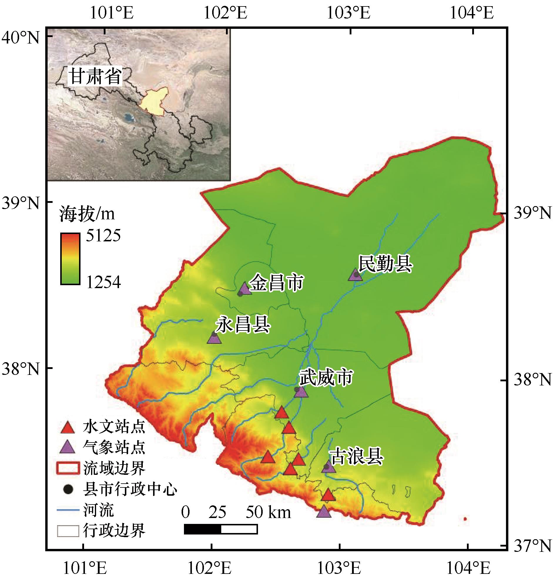
Fig.1 Location of the study area
| 分级标准 | 供需指数SDI取值 |
|---|---|
| 高度赤字 | -1~-0.9 |
| 中高度赤字 | -0.9~-0.7 |
| 中度赤字 | -0.7~-0.5 |
| 轻度赤字 | -0.5~0.0 |
| 轻度盈余 | 0.0~0.5 |
| 中度盈余 | 0.5~0.7 |
| 中高度盈余 | 0.7~0.9 |
| 高度盈余 | 0.9~1.0 |
Table 1 Classification of supply and demand of water production service
| 分级标准 | 供需指数SDI取值 |
|---|---|
| 高度赤字 | -1~-0.9 |
| 中高度赤字 | -0.9~-0.7 |
| 中度赤字 | -0.7~-0.5 |
| 轻度赤字 | -0.5~0.0 |
| 轻度盈余 | 0.0~0.5 |
| 中度盈余 | 0.5~0.7 |
| 中高度盈余 | 0.7~0.9 |
| 高度盈余 | 0.9~1.0 |
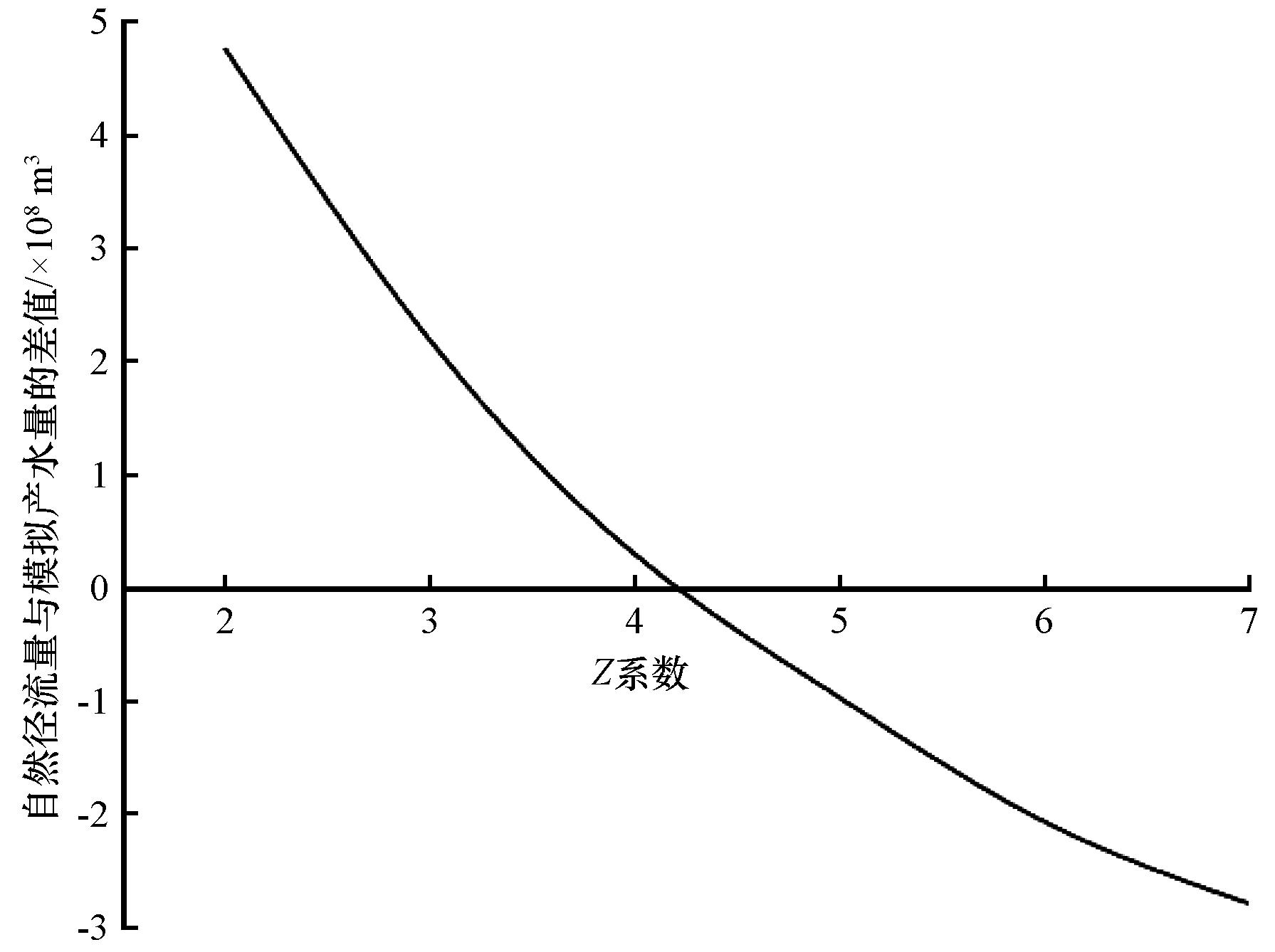
Fig.2 The difference between natural runoff and simulated water yield
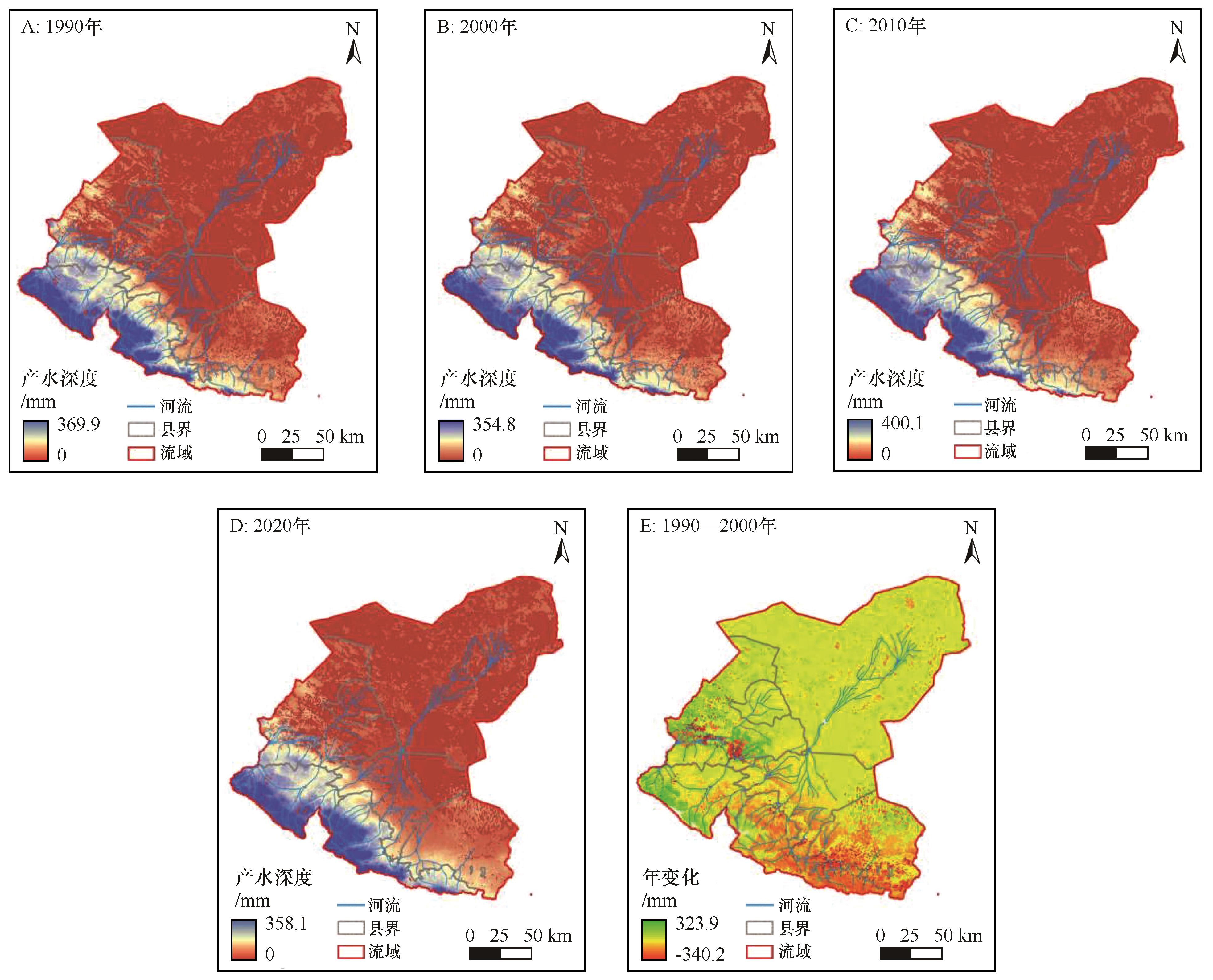
Fig.3 Spatial distribution pattern of water production service supply in the basin from 1990 to 2020
| 年份 | 耕地/mm | 林地/mm | 草地/mm | 水域/mm | 建设用地/mm | 未利用土地/mm | 平均产水深度/mm | 平均产水量/108 m3 |
|---|---|---|---|---|---|---|---|---|
| 1990 | 32.98 | 130.14 | 81.13 | 0.01 | 1.85 | 10.24 | 41.40 | 16.65 |
| 2000 | 36.23 | 136.46 | 86.13 | 0.03 | 1.27 | 10.97 | 43.90 | 17.81 |
| 2010 | 38.48 | 149.46 | 95.40 | 0.05 | 1.23 | 11.61 | 47.75 | 19.37 |
| 2020 | 37.70 | 151.06 | 89.20 | 0.03 | 1.75 | 9.82 | 45.19 | 18.32 |
Table 2 Water yield depth and average water yield of different land use types in the basin from 1980 to 2020
| 年份 | 耕地/mm | 林地/mm | 草地/mm | 水域/mm | 建设用地/mm | 未利用土地/mm | 平均产水深度/mm | 平均产水量/108 m3 |
|---|---|---|---|---|---|---|---|---|
| 1990 | 32.98 | 130.14 | 81.13 | 0.01 | 1.85 | 10.24 | 41.40 | 16.65 |
| 2000 | 36.23 | 136.46 | 86.13 | 0.03 | 1.27 | 10.97 | 43.90 | 17.81 |
| 2010 | 38.48 | 149.46 | 95.40 | 0.05 | 1.23 | 11.61 | 47.75 | 19.37 |
| 2020 | 37.70 | 151.06 | 89.20 | 0.03 | 1.75 | 9.82 | 45.19 | 18.32 |
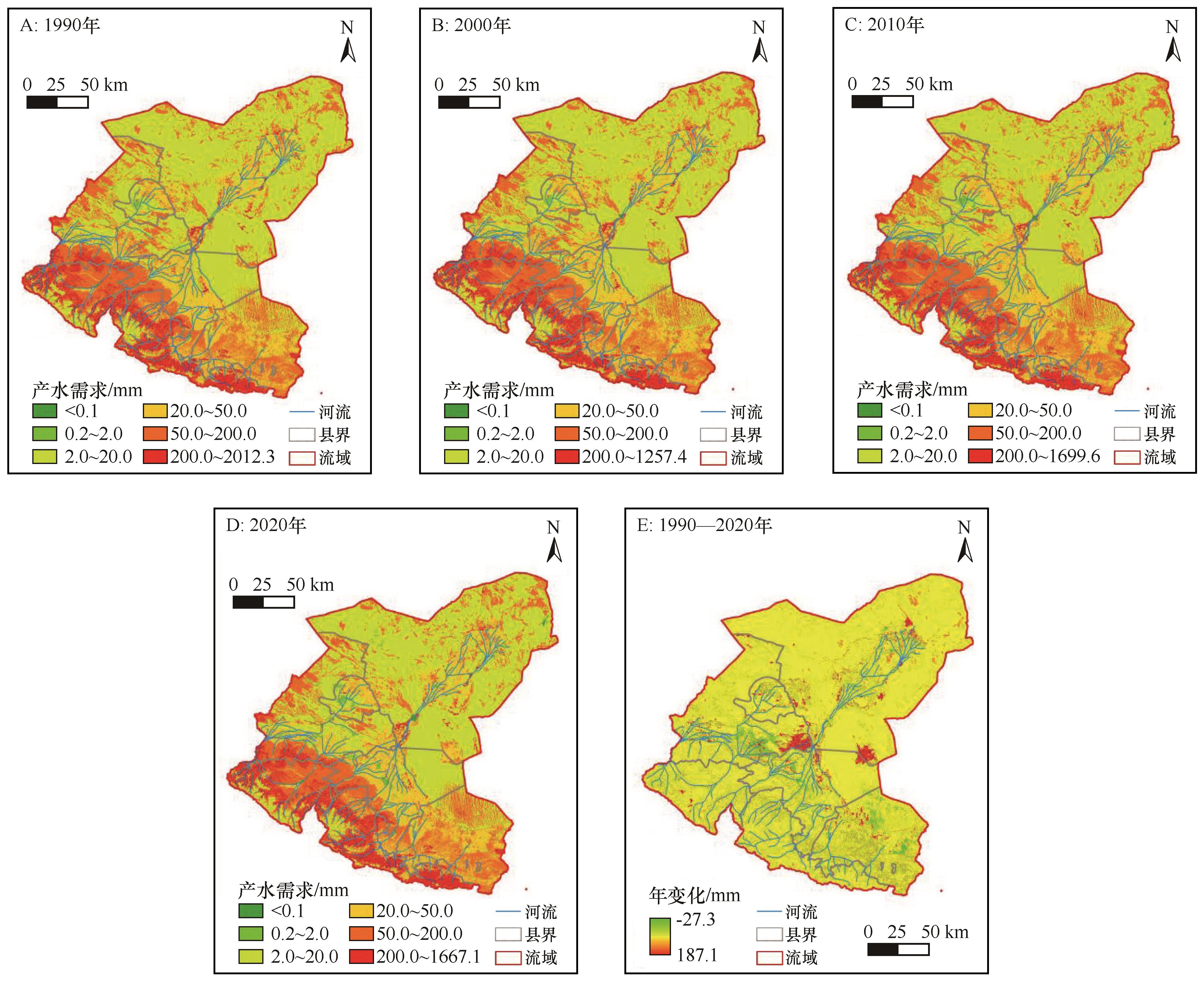
Fig.4 Spatial distribution pattern of water production service demand in the basin from 1990 to 2020
| 年份 | 耕地 | 林地 | 草地 | 建设用地 | 需求总量 |
|---|---|---|---|---|---|
| 1990 | 15.20 | 0.72 | 1.46 | 3.01 | 20.39 |
| 2000 | 15.88 | 0.47 | 0.83 | 1.89 | 19.07 |
| 2010 | 14.93 | 0.47 | 0.94 | 2.99 | 19.33 |
| 2020 | 13.70 | 0.45 | 0.60 | 3.03 | 17.78 |
Table 3 Water production service demand and annual total demand of various land use types in the basin from 1990 to 2020
| 年份 | 耕地 | 林地 | 草地 | 建设用地 | 需求总量 |
|---|---|---|---|---|---|
| 1990 | 15.20 | 0.72 | 1.46 | 3.01 | 20.39 |
| 2000 | 15.88 | 0.47 | 0.83 | 1.89 | 19.07 |
| 2010 | 14.93 | 0.47 | 0.94 | 2.99 | 19.33 |
| 2020 | 13.70 | 0.45 | 0.60 | 3.03 | 17.78 |
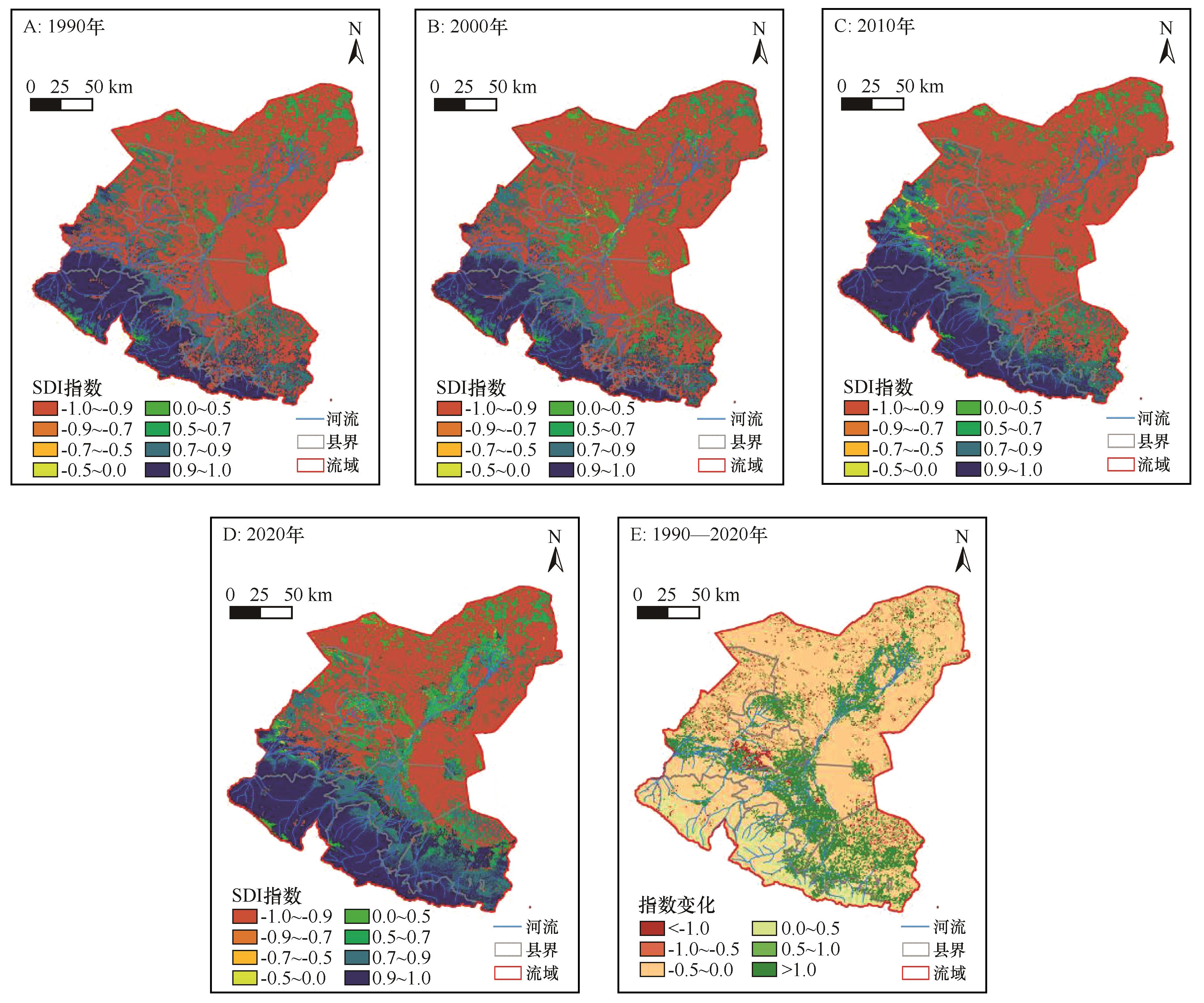
Fig.5 Spatial distribution pattern of water supply and demand difference in the basin from 1990 to 2020
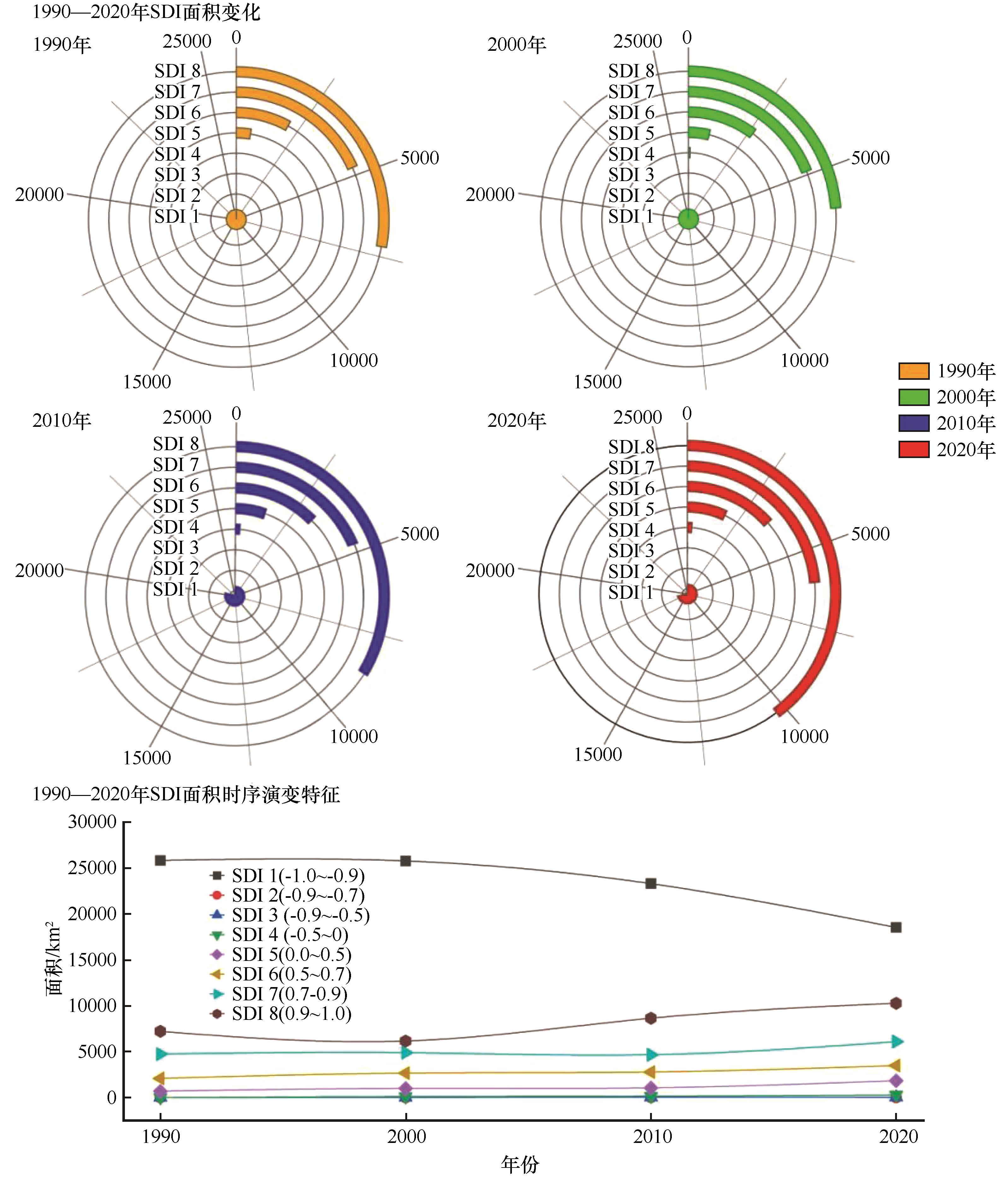
Fig.6 The area change and time series evolution characteristics of supply-demand index from 1990 to 2020
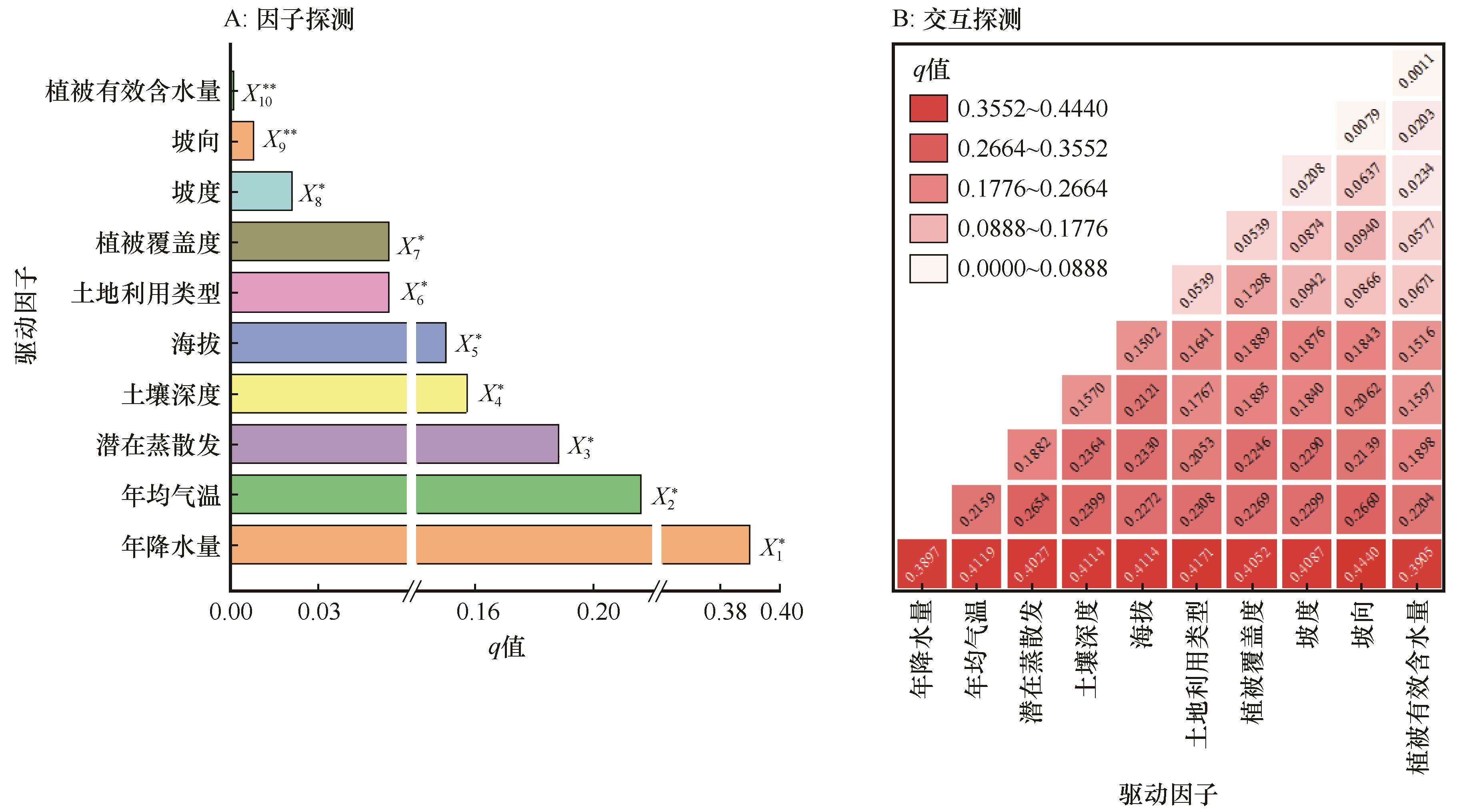
Fig.7 Detection results of driving factors of spatial pattern of water supply in watershed
| 1 | Costanza R, d'Arge R, deGroot R,et al.The value of the world's ecosystem services and natural capital[J].Nature,1997,387(6630):253-260. |
| 2 | Chen S L, Liu X T, Yang L,et al.Variations in ecosystem service value and its driving factors in the Nanjing metropolitan area of China[J].Forests,2023,14(1):113. |
| 3 | Wang D H, Tian Y C, Zhang Y L,et al.Evaluation and quantitative attribution analysis of water yield services in the Peak-cluster Depression Basins in southwest of Guangxi,China[J].Chinese Geographical Science,2023,33(1):116-130. |
| 4 | Zhang T, Gao Q, Xie H M,et al.Response of water yield to future climate change based on InVEST and CMIP6:a case study of the Chaohu Lake Basin[J].Sustainability,2022,14(21):14080. |
| 5 | Zhang X, Zhang G S, Long X,et al.Identifying the drivers of water yield ecosystem service: a case study in the Yangtze River Basin,China[J].Ecological Indicators,2021,132(7401):108304. |
| 6 | Zhang J H, Zhang Y L, Sun G,et al.Climate variability masked greening effects on water yield in the Yangtze River Basin during 2001-2018[J].Water Resources Research,2022,58(1):e2021WR030382. |
| 7 | Su Y Q, Ma X H, Feng Q,et al.Patterns and controls of ecosystem service values under different land-use change scenarios in a mining-dominated basin of northern China[J].Ecological Indicators,2023,151:110321. |
| 8 | Wang M, Jiang B, Alatalo M J,et al.Improved ecological monitoring for urban ecosystem protection in China[J].Ecological Indicators,2021,120:106950. |
| 9 | Wang Y X, Wang H M, Liu G,et al.Factors driving water yield ecosystem services in the Yellow River Economic Belt,China:spatial heterogeneity and spatial spillover perspectives[J].Journal of Environmental Management,2022,317:115477. |
| 10 | Su Y Q, Feng Q, Liu W,et al.Improved understanding of trade-offs and synergies in ecosystem services via fine land-use classification and multi-scale analysis in the arid region of Northwest China[J].Remote Sensing,2023,15(20):4976. |
| 11 | Yang H, Hou X L, Cao J S.Identifying the driving impact factors on water yield service in mountainous areas of the Beijing-Tianjin-Hebei region in China[J].Remote Sensing,2023,15(3):727. |
| 12 | Wu C X, Qiu D X, Gao P,et al.Application of the InVEST model for assessing water yield and its response to precipitation and land use in the Weihe River Basin,China[J].Journal of Arid Land,2022,14(4):426-440. |
| 13 | Pei H W, Liu M Z, Shen Y J,et al.Quantifying impacts of climate dynamics and land-use changes on water yield service in the agro-pastoral ecotone of northern China[J].The Science of The Total Environment,2021,809:151-153. |
| 14 | 彭赤彬,钱湛,姜恒,等.沅江流域产水服务功能的时空变化及驱动力分析[J].人民长江,2023,54(6):95-102. |
| 15 | 孙宝娣,于德湖,崔东旭.流域生态系统服务和水土资源匹配研究进展[J].生态学报,2023,43(10):4308-4318. |
| 16 | 郭军庭,张志强,王盛萍,等.应用SWAT模型研究潮河流域土地利用和气候变化对径流的影响[J].生态学报,2014,34(6):1559-1567. |
| 17 | 崔越,张利华,吴宗钒,等.基于BEPS-Terrainlab v2.0模型鄂西犟河流域1999年-2016年蒸散发模拟分析[J].华中师范大学学报(自然科学版),2020,54(1):140-148. |
| 18 | 贾雨凡,王国庆.基于InVEST模型的伊洛河流域水源涵养能力评估[J].水土保持学报,2023,37(3):101-108. |
| 19 | 李莹莹,马晓双,祁国华,等.基于参数本地化InVEST模型的安徽省水源涵养功能研究[J].长江流域资源与环境,2022,31(2):313-325. |
| 20 | 李芳,张金龙,杨环.基于InVEST模型的黑河流域上游1990-2018年产水量模拟[J].高原气象,2022,41(3):698-707. |
| 21 | 杨昀则,田鹏,张海涛,等.基于InVEST模型的甬江流域水源供给功能时空变化特征[J].水资源与水工程学报,2022,32(5):107-117. |
| 22 | Leh M D K, Matlock M D, Cummings E C,et al.Quantifying and mapping multiple ecosystem services change in West Africa[J].Agriculture,Ecosystems Environment,2013,165:6-18. |
| 23 | Marquès M, Bangash R F, Kumar V,et al.The impact of climate change on water provision under a low flow regime:a case study of the ecosystems services in the Francoli River Basin[J].Journal of Hazardous Materials,2013,263:224-232. |
| 24 | 戴尔阜,王亚慧.横断山区产水服务空间异质性及归因分析[J].地理学报,2020,75(3):607-619. |
| 25 | 丁家宝,张福平,张元,等.气候与土地利用变化背景下青海湖流域产水量时空变化[J].兰州大学学报(自然科学版),2022,58(1):47-56. |
| 26 | 朱志洪,周本智,王懿祥,等.近30年千岛湖流域产水量时空变化及其影响因子分析[J].南京林业大学学报(自然科学版),2023,47(3):111-119. |
| 27 | 王壮壮,张立伟,李旭谱,等.区域生态系统服务供需风险时空演变特征:以陕西省产水服务为例[J].生态学报,2020,40(6):1887-1900. |
| 28 | 赵亚茹,周俊菊,雷莉,等.基于InVEST模型的石羊河上游产水量驱动因素识别[J].生态学杂志,2019,38(12):3789-3799. |
| 29 | 唐红林,陈佳,刘倩,等.生态治理下石羊河流域农户生计转型路径、效应及机理[J].地理研究,2023,42(3):822-841. |
| 30 | 徐柏翠,潘竟虎,孙旭伟.基于服务流的石羊河流域水供给服务关键区域识别[J].应用生态学报,2022,33(12):3379-3387. |
| 31 | 王玉纯,赵军,付杰文,等.石羊河流域水源涵养功能定量评估及空间差异[J].生态学报,2018,38(13):4637-4648. |
| 32 | 娄梦婕,史明昌,郭虹扬,等.基于InVEST模型的白洋淀-大清河流域水源涵养分析[J].中国水土保持科学(中英文),2022,20(5):118-123. |
| 33 | 陈德权,兰泽英,陈晓辉,等.InVEST模型在市县级水源涵养功能评价中的应用:以广东省广州市为例[J].水土保持通报,2021,41(4):196-206. |
| 34 | 贾雯霞,张艳,崔国屹.汾河流域生态系统服务供需匹配关系研究[J].贵州师范大学学报(自然科学版),2023,41(2):15-23. |
| 35 | 曾建军,李元红,金彦兆,等.InVEST模型在石羊河流域生态系统水源供给中的应用前景与方法[J].水资源与水工程学报,2015,26(6):83-87. |
| 36 | 刘立程,刘春芳,王川,等.黄土丘陵区生态系统服务供需匹配研究:以兰州市为例[J].地理学报,2019,74(9):1921-1937. |
| 37 | 陈骏宇,王慧敏,刘钢,等.“水-能-粮”视角下杭嘉湖区域生态系统服务供需测度及政策研究[J].长江流域资源与环境,2019,28(3):542-553. |
| 38 | 赵晓冏,苏军德,王建,等.甘肃省生态服务供需关系及影响因子研究[J].中国环境科学,2021,41(10):4926-4941. |
| 39 | 王晓峰,程昌武,尹礼唱,等.新疆生态系统服务时空变化及权衡协同关系[J].生态学杂志,2020,39(3):990-1000. |
| 40 | 钟孟君,蒋贵国,陆忆文,等.中巴经济走廊巴基斯坦段产水服务供需风险评价及分区[J].水土保持通报,2023,43(3):225-233. |
| 41 | 刘昌明,傅国斌.气候变化对中国水文情势影响的若干分析[M]//张翼等.气候变化及其影响.北京:气象出版社,1993. |
| 42 | 王蓓.基于InVEST模型的石羊河流域生态系统服务功能时空变化研究[D].兰州:西北师范大学,2017. |
| 43 | 张利利.基于InVEST模型的石羊河上游产水量变化及其对气候与土地利用变化的响应[D].兰州:西北师范大学,2017. |
| 44 | 黄欣,彭双云,王哲,等.基于地理探测器的云南省生态系统产水服务的空间异质性及驱动因素[J].应用生态学报,2022,33(10):2813-2821. |
| 45 | 王晓峰,符鑫鑫,楚冰洋,等.秦岭生态屏障产水服务时空演变特征及驱动要素[J].自然资源学报,2021,36(10):2507-2521. |
| 46 | 王劲峰,徐成东.地理探测器:原理与展望[J].地理学报,2017,72(1):116-134. |
| 47 | 苏迎庆,刘庚,赵景波,等.2006-2018年汾河流域土地生态安全预警测度及时空格局演变[J].水土保持通报,2021,41(1):144-151. |
| 48 | 刘海龙,王炜桥,王跃飞,等.汾河流域生态敏感性综合评价及时空演变特征[J].生态学报,2021,41(10):3952-3964. |
| 49 | 伍堂银,周忠发,张露,等.基于InVEST模型的南北盘江流域产水量时空变化研究[J].水土保持通报,2023,43(3):129-138. |
| 50 | 陈吉平,牛最荣,黄维东,等.甘肃省河西内陆河实测出山径流量变化及其影响因素分析[J].中国农村水利水电,2024(10):7-14. |
| 51 | 李瑶,董增川,张城,等.基于SWAT模型和Budyko假设的石羊河流域径流变化归因对比分析[J].人民黄河,2023,45(7):30-35. |
| 52 | 李小琴,冉宸,张晓霞,等.近60 a石羊河流域蒸发量变化及其原因分析[J].干旱区研究,2022,39(3):745-753. |
| 53 | 张福平,李肖娟,冯起,等.基于InVEST模型的黑河流域上游水源涵养量[J].中国沙漠,2018,38(6):1321-1329. |
| [1] | Xiaoyu Zhang, Zixiang Zhou, Zhixiong Tang, Yanxu Sun. Spatio-temporal variation and prediction of habitat quality in Wuding River Basin [J]. Journal of Desert Research, 2024, 44(3): 75-84. |
| [2] | Chengwei Zheng, Xiaohong Deng, Zongxing Li, Jian Xue, Libang Ma, Juan He, Shuxiang Lu, Jianxiong Shao, Shiyu Cai, Peiyi Zhao. Analysis of the spatial and temporal evolution of water resources conservation and human activity intensity in the Hexi region of Gansu Province [J]. Journal of Desert Research, 2024, 44(1): 189-200. |
| [3] | Chenxi Xu, Honglian Wan, Ruonan He, Peng Yin, Jingfeng Ni, Min Huang, Xiaoli Wang. Research on spatio-temporal evolution and driving factors of urban agglomeration vulnerability in Guanzhong Plain [J]. Journal of Desert Research, 2023, 43(6): 111-120. |
| [4] | Yuxi Wei, Lijuan Chen, Haiyang Xi, Chengqi Zhang, Kaiyuan Gan, Tian Yong, Jinxia Zhang. Spatial differentiation of soil moisture and conductivity in Shiyang River Basin [J]. Journal of Desert Research, 2023, 43(3): 264-273. |
| [5] | Ran Duan, Zongjie Li, Yu Wang, Xiaoying Liu, Juan Gui, Pengfei Liang, Yuchen Li, Jian Xue, Mengqing Liu, Bin Xu. Characteristics of runoff change in the Shiyang River Basin [J]. Journal of Desert Research, 2023, 43(3): 57-68. |
| [6] | Yaowen Zhang, Bo Zhang, Rongpeng Yao, Libing Wang. Temporal and spatial changes of vegetation coverage and water production in the Weihe River Basin from 2000 to 2020 [J]. Journal of Desert Research, 2022, 42(2): 223-233. |
| [7] | Baorong Xu, Yichuan Liu, Ying Dong, Gong Zhu, Yongzhong Zhang, Zhixiang Lu, Songbing Zou. Evaluation of habitat quality in Lanzhou Region based on InVEST model [J]. Journal of Desert Research, 2021, 41(5): 120-129. |
| [8] | Jie Yang, Baopeng Xie, Degang Zhang. Spatial-temporal evolution of habitat quality and its influencing factors in the Yellow River Basin based on InVEST model and GeoDetector [J]. Journal of Desert Research, 2021, 41(4): 12-22. |
| [9] | Shan Huang, Qi Feng, Yaobin Wang, Zhixiang Lu. The evaluation of integrated water resource management performance in Shiyang River Basin, China [J]. Journal of Desert Research, 2021, 41(2): 67-74. |
| [10] | Mengzhu Liu, Yanfang Wang, Hongwei Pei. The changes of land use and carbon storage in the northern farming-pastoral ecotone under the background of returning farmland to forest (grass) [J]. Journal of Desert Research, 2021, 41(1): 174-182. |
| [11] | Lingping Li, Taishan Lu, Mingchun Liu, Lili Hu, Suping Wang. Characteristics of hydrological drought based on standardized flow index in Shiyang River Basin of China [J]. Journal of Desert Research, 2020, 40(4): 24-33. |
| [12] | Zhang Fuping, Li Xiaojuan, Feng Qi, Wang Huwei, Wei Yongfen, Bai Hao. Spatial and Temporal Variation of Water Conservation in the Upper Reaches of Heihe River Basin Based on InVEST Model [J]. Journal of Desert Research, 2018, 38(6): 1321-1329. |
| [13] | Luo Li, Zhao Xueyan, Wang Yaru, Zhang Qin. Farmers' Perception and Its Influence Factors of Climate Change in the Shiyang River Basin [J]. JOURNAL OF DESERT RESEARCH, 2016, 36(4): 1171-1181. |
| [14] | DONG Wen, YANG Yu, ZHANG Xiao-lei. Spatio-temporal Variation of Urban Development and Water Resource Benefit in Oasis Cities of Xinjiang [J]. JOURNAL OF DESERT RESEARCH, 2012, 32(5): 1463-1471. |
| [15] | LI Ling-ping, LI Yan-ying, LIU Ming-chun. Change Trend of Pan Evaporation and Its Causes in Shiyang River Basin during 1961—2005 [J]. JOURNAL OF DESERT RESEARCH, 2012, 32(3): 832-841. |
| Viewed | ||||||
|
Full text |
|
|||||
|
Abstract |
|
|||||
©2018Journal of Desert Research
Tel:0931-8267545
Email:caiedit@lzb.ac.cn;desert@lzb.ac.cn
Support:Magtech