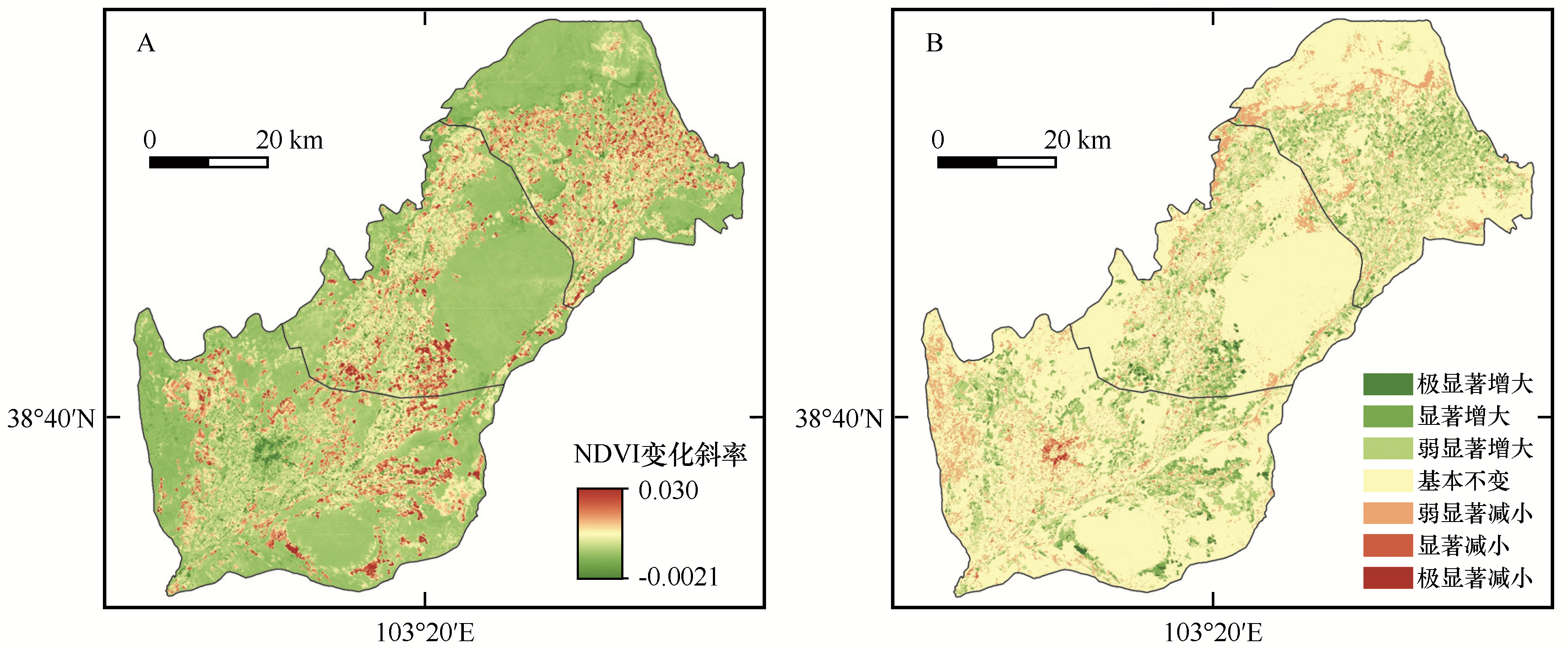
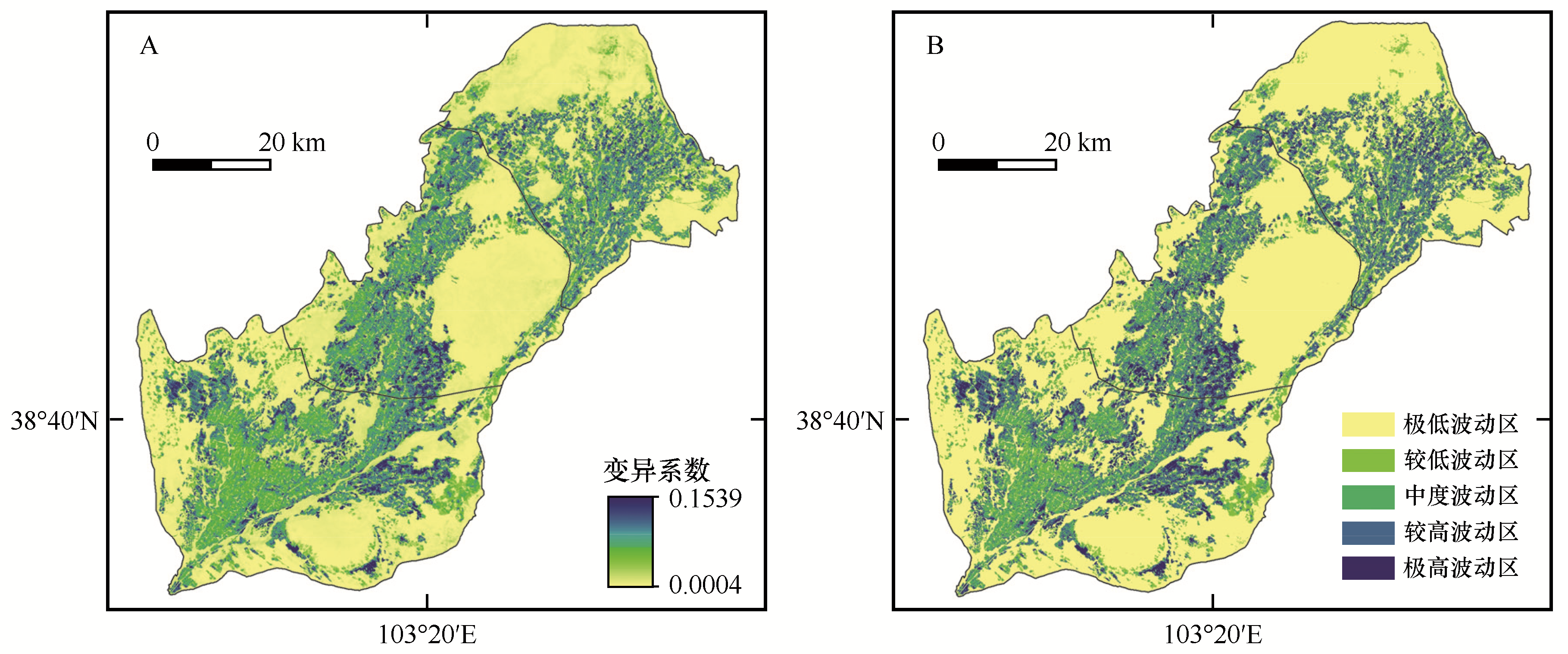
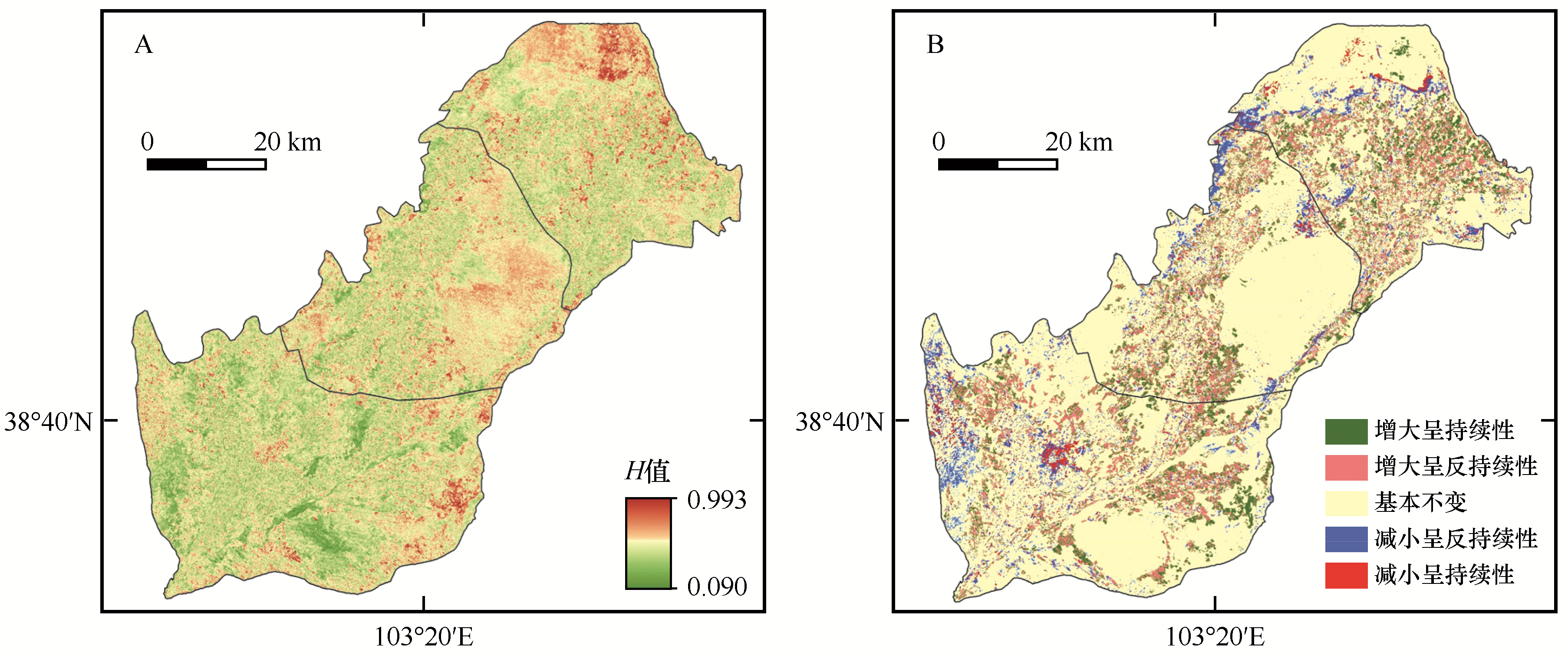
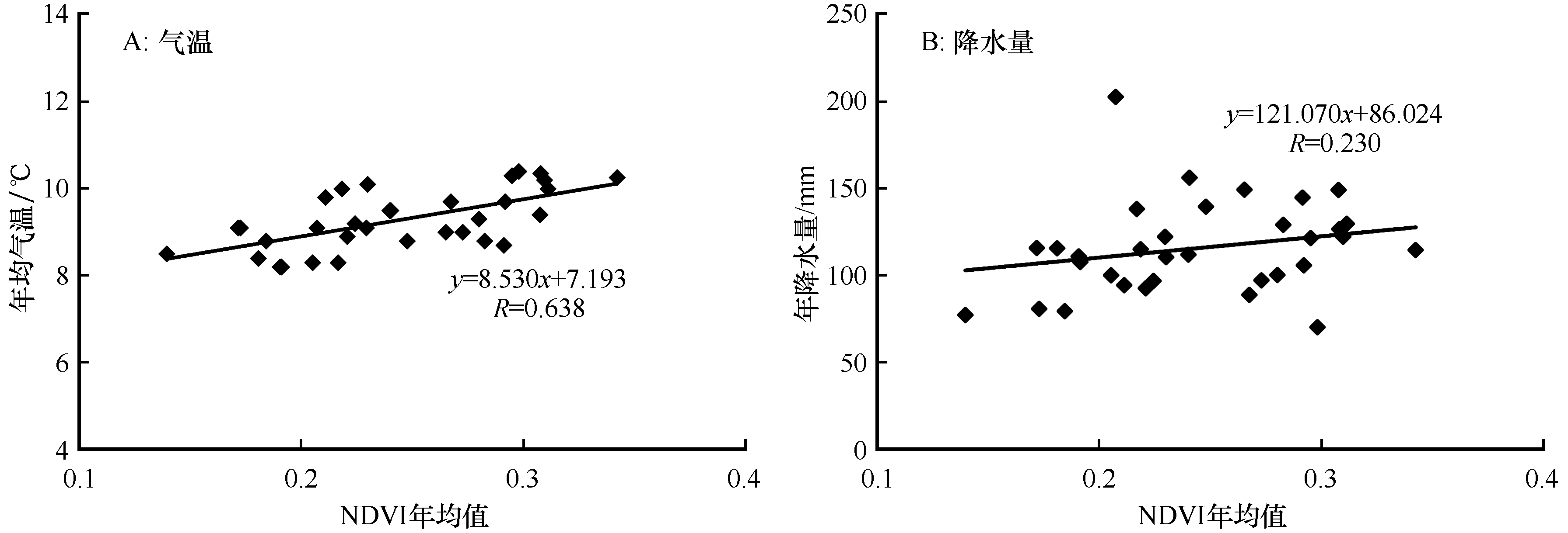
| 1 |
王新源,连杰,杨小鹏,等.玛曲县植被覆被变化及其对环境要素的响应[J].生态学报,2019,39(3):923-935.
|
| 2 |
刘婵,赵文智,刘冰,等.基于无人机和MODIS数据的巴丹吉林沙漠植被分布特征与动态变化研究[J].中国沙漠,2019,39(4):92-102.
|
| 3 |
张华,陈蕾.基于线性光谱混合模型(LSMM)的民勤绿洲荒漠化治理效果评价[J].中国沙漠,2019,39(3):145-154.
|
| 4 |
王晓利,侯西勇.1982-2014年中国沿海地区归一化植被指数(NDVI)变化及其对极端气候的响应[J].地理研究,2019,38(4):807-821.
|
| 5 |
高江波,焦珂伟,吴绍洪.1982-2013年中国植被NDVI空间异质性的气候影响分析[J].地理学报,2019,74(3):534-543.
|
| 6 |
鲁晖,颉耀文,张文培,等.1986-2015年民勤县绿洲时空变化分析[J].干旱区研究,2017,34(6):1410-1417.
|
| 7 |
杨玲莉.2000-2014年黄河源区植被NDVI时空变化特征与气候变化响应分析[D].成都:成都理工大学,2016.
|
| 8 |
郝媛媛.基于GIS/RS的西北内陆河流域生态恢复效果评价研究[D].兰州:兰州大学,2017.
|
| 9 |
陈亚宁,李稚,范煜婷,等.西北干旱区气候变化对水文水资源影响研究进展[J].地理学报,2014,69(9):1295-1304.
|
| 10 |
李丽丽,王大为,韩涛.2000-2015年石羊河流域植被覆盖度及其对气候变化的响应[J].中国沙漠,2018,38(5):1108-1118.
|
| 11 |
高志海,李增元,魏怀东,等.基于遥感的民勤绿洲植被覆盖变化定量监测[J].地理研究,2006,25(4):587-595.
|
| 12 |
丁宏伟,王贵玲,黄晓辉.红崖山水库径流量减少与民勤绿洲水资源危机分析[J].中国沙漠,2003,23(1):84-89.
|
| 13 |
颉耀文,陈发虎.基于数字遥感图象的民勤绿洲20年变化研究[J].干旱区研究,2002,19(1):69-74.
|
| 14 |
赵军,王小敏,李东成.基于MODIS的民勤绿洲植被覆盖变化定量分析[J].干旱区资源与环境,2012,26(10):91-96.
|
| 15 |
李双双,延军平,万佳.近10年陕甘宁黄土高原区植被覆盖时空变化特征[J].地理学报,2012,67(7):960-970.
|
| 16 |
Gorelick N,Hancher M,Dixon M,et al.Google Earth Engine:planetary-scale geospatial analysis for everyone[J].Remote Sensing of Environment,2017,202:18-27.
|
| 17 |
张滔,唐宏.基于Google Earth Engine的京津冀2001-2015年植被覆盖变化与城镇扩张研究[J].遥感技术与应用,2018,33(4):593-599.
|
| 18 |
Huang H,Chen Y,Clinton N,et al.Mapping major land cover dynamics in Beijing using all Landsat images in Google Earth Engine[J].Remote Sensing of Environment,2017:166-176.
|
| 19 |
Hao B,Ma M,Li S,et al.Land use change and climate variation in the Three Gorges Reservoir Catchment from 2000 to 2015 based on the Google Earth Engine[J].Sensors,2019,19(9):1-24.
|
| 20 |
Lobell D B,Thau D,Seifert C A,et al.A scalable satellite-based crop yield mapper[J].Remote Sensing of Environment,2015,164:324-333.
|
| 21 |
Donchyts G,Baart F,Winsemius H,et al.Earth's surface water change over the past 30 years[J].Nature Climate Change,2016,6(9):810-813.
|
| 22 |
Chen B,Xiao X,Li X,et al.A mangrove forest map of China in 2015:analysis of time series Landsat 7/8 and Sentinel-1 A imagery in Google Earth Engine cloud computing platform[J].ISPRS Journal of Photogrammetry and Remote Sensing,2017,131:104-120.
|
| 23 |
Hansen M C,Potapov P,Moore R,et al.High-resolution global maps of 21st-century forest cover change[J].Science,2013,342(6160):850-853.
|
| 24 |
郝斌飞,韩旭军,马明国,等.Google Earth Engine在地球科学与环境科学中的应用研究进展[J].遥感技术与应用,2018,33(4):600-611.
|
| 25 |
裴杰,牛铮,王力,等.基于Google Earth Engine云平台的植被覆盖度变化长时间序列遥感监测[J].中国岩溶,2018,37(4):608-616.
|
| 26 |
徐晗泽宇,刘冲,王军邦,等.Google Earth Engine平台支持下的赣南柑橘果园遥感提取研究[J].地球信息科学学报,2018,20(3):396-404.
|
| 27 |
司建华,冯起,席海洋,等.黑河下游额济纳绿洲生态需水关键期及需水量[J].中国沙漠,2013,33(2):560-567.
|
| 28 |
Chander G,Markham B L,Helder D L.Summary of current radiometric calibration coefficients for Landsat MSS,TM,ETM+,and EO-1 ALI sensors[J].Remote Sensing of Environment,2009,113(5):893-903.
|
| 29 |
岳辉,刘英.近15 a陕西省植被时空变化与影响因素分析[J].干旱区地理,2019,42(2):314-323.
|
| 30 |
杜加强,贾尔恒•阿哈提,赵晨曦,等.三江源区近30年植被生长动态变化特征分析[J].草业学报,2016,25(1):1-12.
|
| 31 |
栾金凯,刘登峰,黄强,等.近17年陕西榆林植被指数的时空变化及影响因素[J].生态学报,2018,38(8):2780-2790.
|
| 32 |
代子俊,赵霞,李冠稳,等.基于GIMMS NDVI 3g.v1的近34年青海省植被生长季NDVI时空变化特征[J]. 草业科学,2018,35(4):713-725.
|
| 33 |
赵桔超,朱彦辉,段国辉,等.基于MOD13Q1数据分析2001-2015年西双版纳植被变化特征[J].生态学杂志, 2019,38(4):1083-1092.
|
| 34 |
徐建华.现代地理学中的数学方法[M].北京:高等教育出版社,2002.
|
| 35 |
钟红平,王宏志.2007—2016年湖北省归一化植被指数时空变化特征分析[J].华中师范大学学报(自然科学版),2018,52(4):582-588.
|
| 36 |
龙爽,郭正飞,徐粒,等.基于Google Earth Engine的中国植被覆盖度时空变化特征分析[J].遥感技术与应用,2020,35(2):326-334.
|
| 37 |
袁生禄.石羊河流域水资源大规模开发对生态环境的影响[J].干旱区资源与环境,1991,5(3):44-52.
|
| 38 |
姜宛贝,孙丹峰,孙强强.基于光谱混合分解的民勤生态治理效果评价[J].中国沙漠,2018,38(1):210-218.
|
| 39 |
刘爽,宫鹏.2000—2010年中国地表植被绿度变化[J].科学通报,2012,57(16):1423-1434.
|
| 40 |
王涛.干旱区绿洲化、荒漠化研究的进展与趋势[J].中国沙漠,2009,29(1):1-9.
|
| 41 |
曹博,张勃,马彬,等.2000-2014年甘肃省NDVI时空变化特征[J].中国沙漠,2018,38(2):418-427.
|
 ), 安慧敏


 甘公网安备 62010202000688号