| 1 |
Kong D D,Zhang Q,Vijay P,et al.Seasonal vegetation response to climate change in the Northern Hemisphere (1982-2013)[J].Global and Planetary Change,2017,148:1-8.
|
| 2 |
郭辉,黄粤,李向义,等.基于多尺度遥感数据的塔里木河干流地区植被覆盖动态[J].中国沙漠,2016,36(5):1472-1480.
|
| 3 |
Feng H,Zou B,Luo J.Coverage-dependent amplifiers of vegetation change on global water cycle dynamics[J].Journal of Hydrology,2017,550:220-229.
|
| 4 |
Purevdorj T S,Tateishi R,Ishiyama Y,et al.Relationships between percent vegetation cover and vegetation indices[J].International Journal of Remote Sensing,1998,19(18):3519-3535.
|
| 5 |
刘婵,赵文智,刘冰,等.基于无人机和MODIS数据的巴丹吉林沙漠植被分布特征与动态变化研究[J].中国沙漠,2019,39(4):92-102.
|
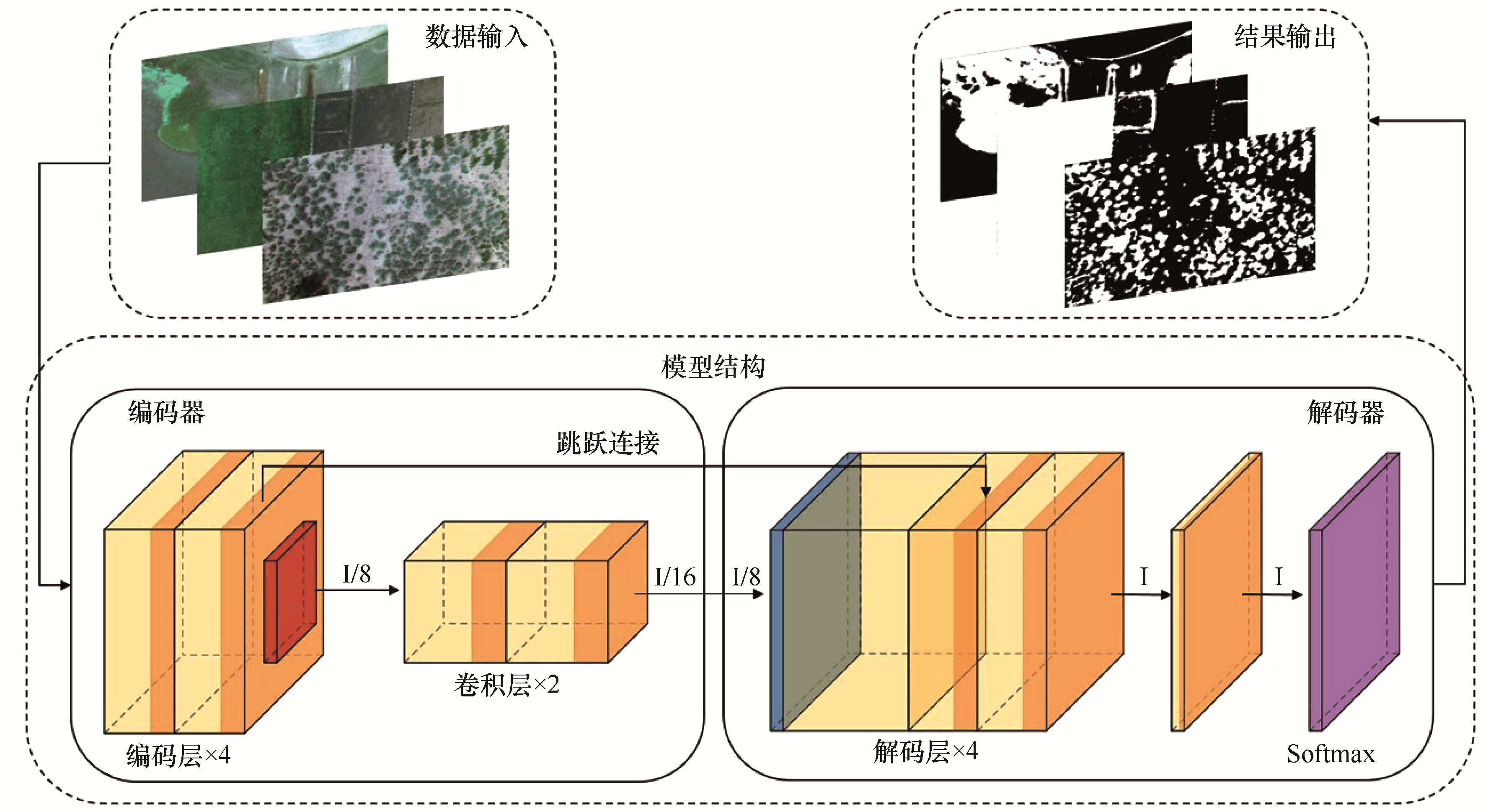
| 6 |
Zhou Q,Wei X,Zhou X,et al.Vegetation coverage change and its response to topography in a typical karst region:the Lianjiang River Basin in Southwest China[J].Environmental Geology,2019,78(6):191-201.
|
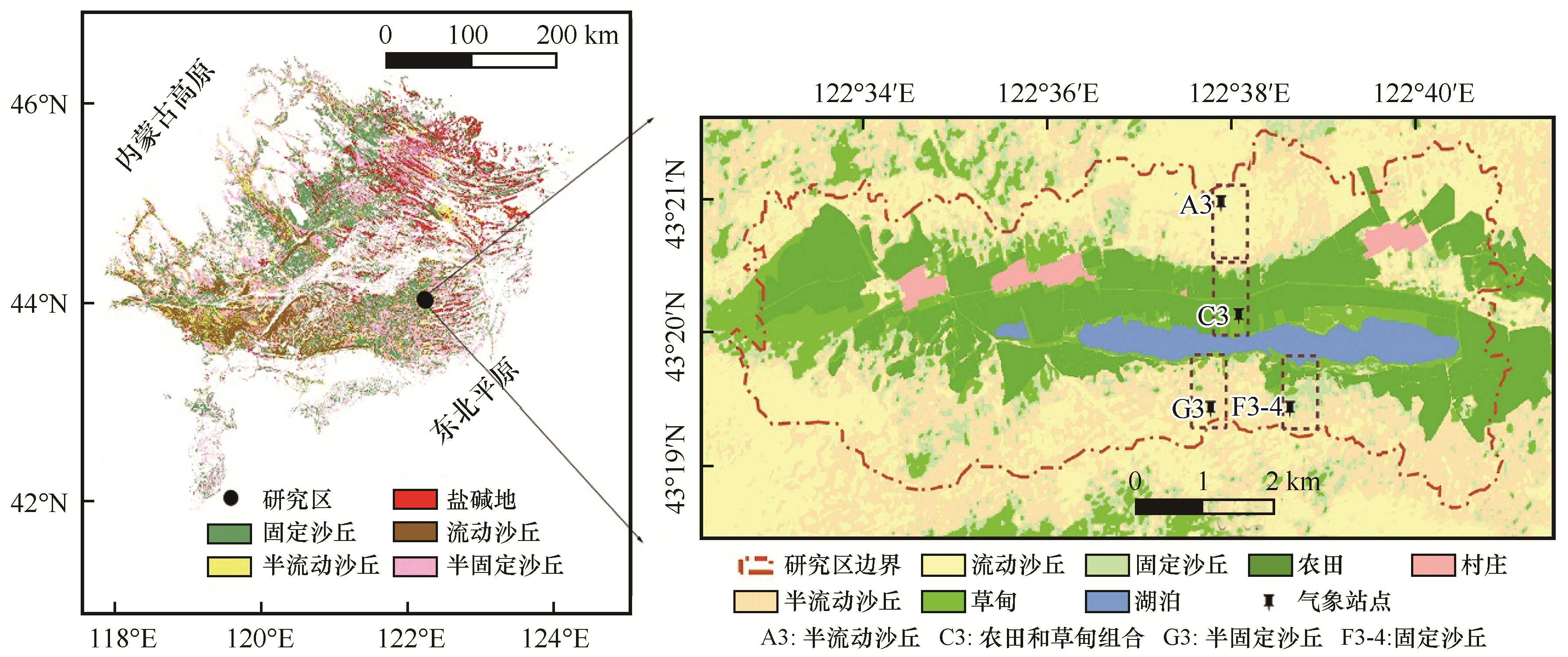
| 7 |
古丽·加帕尔,陈曦,包安明.干旱区荒漠稀疏植被覆盖度提取及尺度扩展效应[J].应用生态学,2009,20(12):2925-2934.
|
| 8 |
Anderson K,Gaston K J.Lightweight unmanned aerial vehicles will revolutionize spatial ecology[J].Frontiers in Ecology and the Environment,2013,11(3):138-146.
|
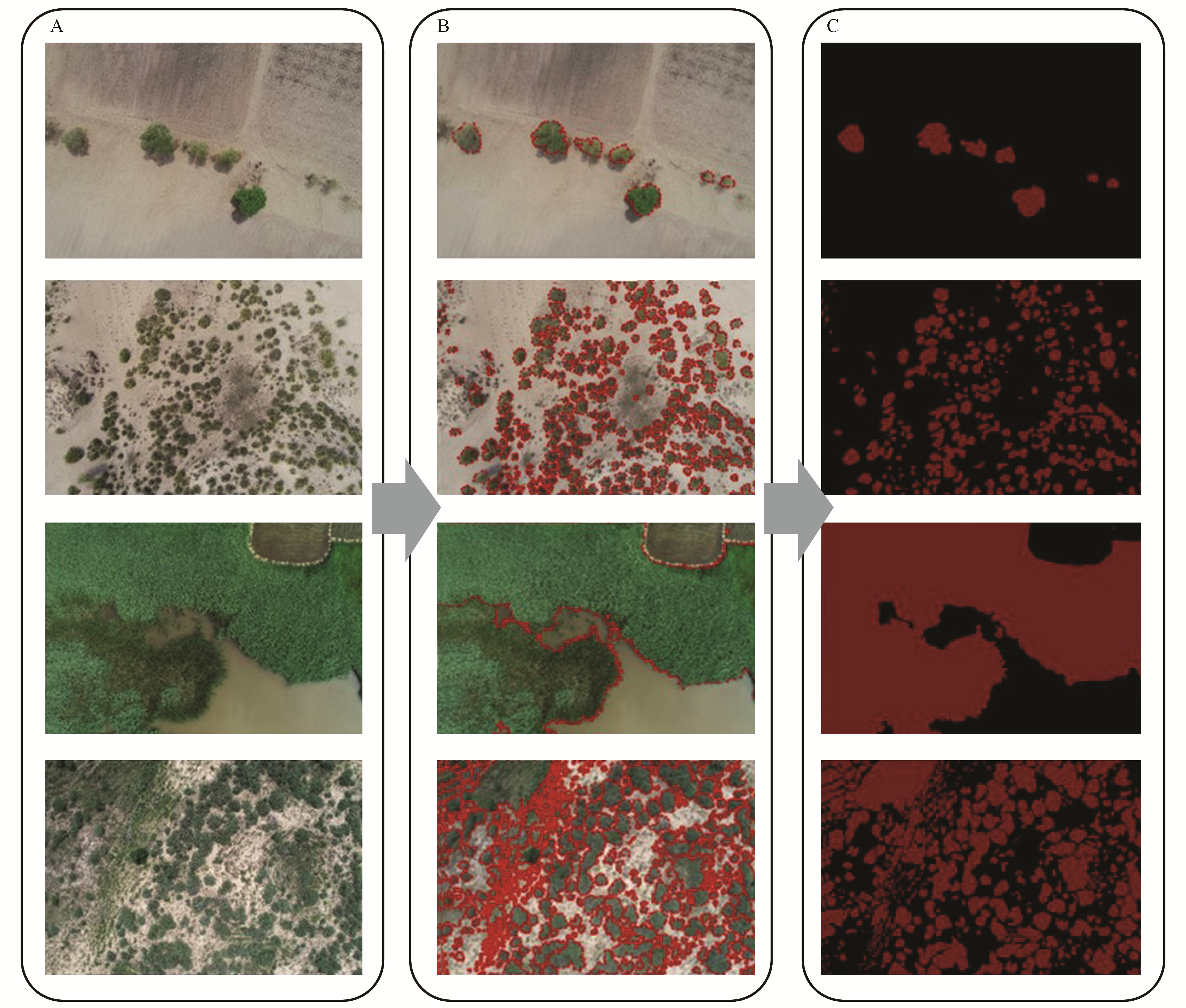
| 9 |
韩东,王浩舟,郑邦友,等.基于无人机和决策树算法的榆树疏林草原植被类型划分和覆盖度生长季动态估计[J].生态学报,2018,38(18):6655-6663.
|
| 10 |
Al-Ali Z M,Abdullah M M,Asadalla N B,et al.A comparative study of remote sensing classification methods for monitoring and assessing desert vegetation using a UAV-based multispectral sensor[J].Environmental Monitoring and Assessment,2020,192(6):10.1007/s10661-020-08330-1.
|
| 11 |
Yan G,Li L,Coy A,et al.Improving the estimation of fractional vegetation cover from UAV RGB imagery by colour unmixing[J].ISPRS Journal of Photogrammetry and Remote Sensing,2019,158:23-34.
|
| 12 |
Marcial P,Gonzalez S,Jimenez J,et al.Estimation of vegetation fraction using RGB and multispectral images from UAV[J].International Journal of Remote Sensing,2019,40(2):420-438.
|
| 13 |
谢兵,杨武年,王芳.无人机可见光光谱的植被覆盖度估算新方法[J].测绘科学,2020,45(9):72-77.
|
| 14 |
Zhang X,Zhang F,Qi Y,et al.New research methods for vegetation information extraction based on visible light remote sensing images from an unmanned aerial vehicle (UAV)[J].International Journal of Applied Earth Observation and Geoinformation,2019,78:215-226.
|
| 15 |
Long J,Shelhamer E,Darrell T.Fully convolutional networks for sementation[J].IEEE Transactions on Pattern Analysis and Machine Intelligence,2014,39(4):640-651.
|
| 16 |
Minh D H T,Ienco D,Gaetano R,et al.Deep recurrent neural networks for winter vegetation quality mapping via multitemporal SAR Sentinel-1[J].IEEE Geoscience and Remote Sensing Letters,2018,15(3):464-468.
|
| 17 |
刘文雅,潘洁.基于神经网络的马尾松叶绿素含量高光谱估算模型[J].应用生态学报,2017,28(4):1128-1136.
|
| 18 |
王宇祥,刘廷玺,段利民,等.基于Hydrus-1D模型的科尔沁沙地沙丘-草甸相间区土壤水分动态模拟[J].中国沙漠,2020,40(2):195-205.
|
| 19 |
曹文梅,刘小燕,王冠丽,等.科尔沁沙地自然植被与生境因子的MRT分类及DCCA分析[J].生态学杂志,2017,36(2):318-327.
|
| 20 |
Jaud M,Passot S,Réjanne L B,et al.Assessing the accuracy of high resolution digital surface models computed by PhotoScan and MicMac in sub-optimal survey conditions[J].Remote Sensing,2017,8(6):10.3390/rs8060465.
|
| 21 |
李航.统计学习方法[M].北京:清华大学出版社,2012:18-19.
|
| 22 |
阿荣,毕其格,董振华.基于MODIS/NDVI的锡林郭勒草原植被变化及其归因[J].资源科学,2019,41(7):1374-1386.
|
| 23 |
Turner D,Lucieer A,Watson C.An automated technique for generating georectified mosaics from ultra-high resolution Unmanned Aerial Vehicle (UAV) imagery based on Structure from Motion (SfM) point clouds[J].Remote Sensing,2012,4:1392-1410.
|
| 24 |
郝梦宇,秦龙君,毛鹏,等.基于无人机可见光影像的荒漠植被分布格局研究方法[J].中国沙漠,2020,40(6):169-179.
|
| 25 |
Kotaro L,Tsuyoshi K,Sisva S,et al.Estimating and examining the sensitivity of different vegetation indices to fractions of vegetation cover at different scaling grids for early stage acacia plantation forests using a fixed-wing UAS[J].Remote Sensing,2019,11(15):10.3390/rs11151816.
|
| 26 |
Quan L F,Jian T L,Jian H G.UAV remote sensing for urban vegetation mapping using random forest and texture analysis[J].Remote Sensing,2015,7(1):1074-1094.
|
| 27 |
Jia K,Liang S,Gu X,et al.Fractional vegetation cover estimation algorithm for Chinese GF-1 wide field view data[J].Remote Sensing of Environment,2016,177(5):184-191.
|
| 28 |
Wang H,Mu Y,Jiang L.Landscape-level vegetation classification and fractional woody and herbaceous vegetation cover estimation over the dryland ecosystems by unmanned aerial vehicle platform[J].Agricultural and Forest Meteorology,2019,278:10.1016/j.agrformet.2019.107665.
|
| 29 |
Diaz-Varela R A,Iglesias S C,Castro C C,et al.Sub-metric analisis of vegetation structure in bog-heathland mosaics using very high resolution rpas imagery[J].Ecological indicators:Integrating,Monitoring,Assessment and Management,2018,89:10.1016/j.ecolind.2017.11.068.
|
| 30 |
Salamí E,Cristina B,Enric P.UAV flight experiments applied to the remote sensing of vegetated areas[J].Remote Sensing,2014,6(11):11051-11081.
|
| 31 |
Cruzan M B,Weinstein B G,Grasty M R,et al.Small Unmanned Aerial Vehicles (Micro-Uavs,Drones) in plant ecology[J].Applications in Plant ences,2016,4(9):10.3732/apps.1600041.
|
| 32 |
胡广录,赵文智,王岗.干旱荒漠区斑块状植被空间格局及其防沙效应研究进展[J].生态学报,2011,31(24):7609-7616.
|
| 33 |
周建,张凤荣,徐艳,等.基于降水量与土壤类型的北方农牧交错区土地利用/覆被格局及变化分析:以科尔沁左翼后旗为例[J].地理研究,2017,36(7):1210-1222.
|
| 34 |
Wang Z,Luo T X,Li R C,et al.Causes for the unimodal pattern of biomass and productivity in alpine grasslands along a large altitudinal gradient in semi‐arid regions[J].Journal of Vegetation Science,2013,24(1).189-201.
|
| 35 |
梁存柱,刘钟龄,朱宗元,等.阿拉善荒漠区一年生植物层片物种多样性及其分布特征[J].应用生态学报,2003,14(6):897-903.
|
| 36 |
王举凤,何亮,陆绍娟,等.内蒙古不同类型草原光合植被覆盖度对降水变化的响应[J].生态学报,2020,40(16):5620-5629.
|
| 37 |
唐亮,何明珠,许华,等.基于无人机低空遥感的荒漠植被覆盖度与归一化植被指数验证及其对水热梯度的响应[J].应用生态学报,2020,31(1):35-44.
|
| 38 |
Duo A,Zhao W,Qu X,et al.Spatio-temporal variation of vegetation coverage and its response to climate change in North China plain in the last 33 years[J].International Journal of Applied Earth Observation and Geoinformation,2016,53:103-117.
|
| 39 |
Gu Z J,Duan X W,Shi Y D,et al.Spatiotemporal variation in vegetation coverage and its response to climatic factors in the Red River Basin,China[J].Ecological Indicators,2018,93:54-64.
|
 ), 刘廷玺a,b(

 甘公网安备 62010202000688号