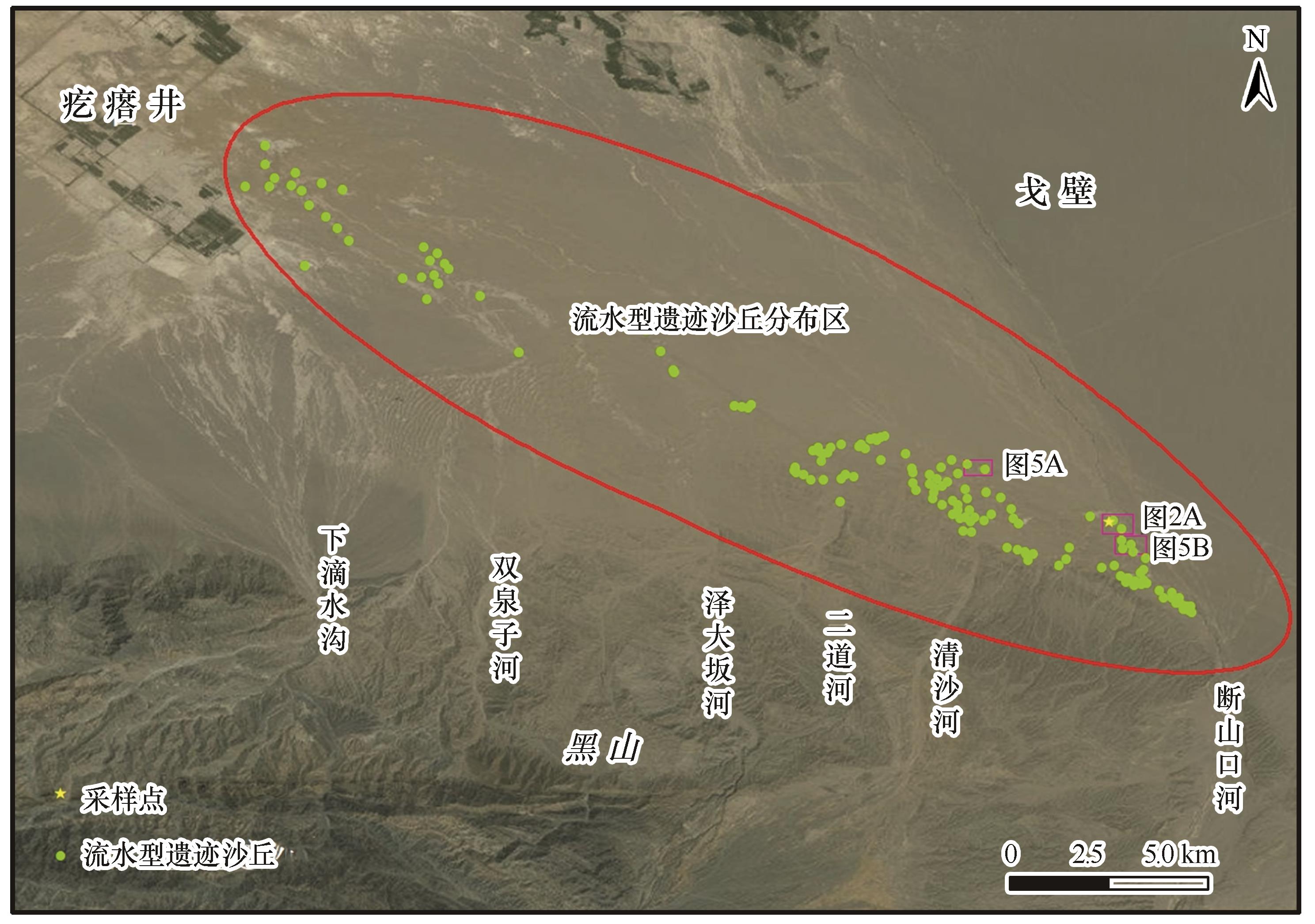
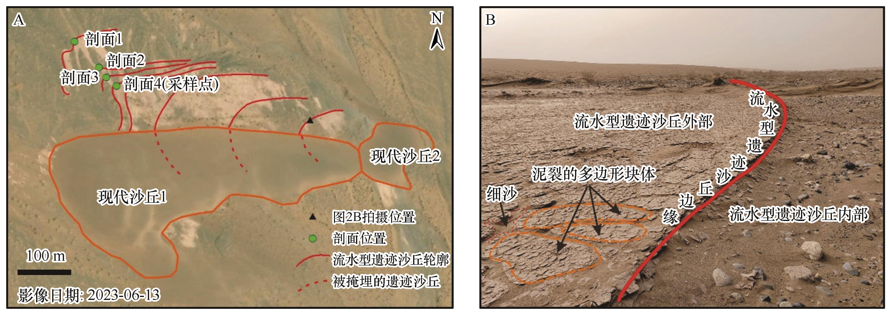
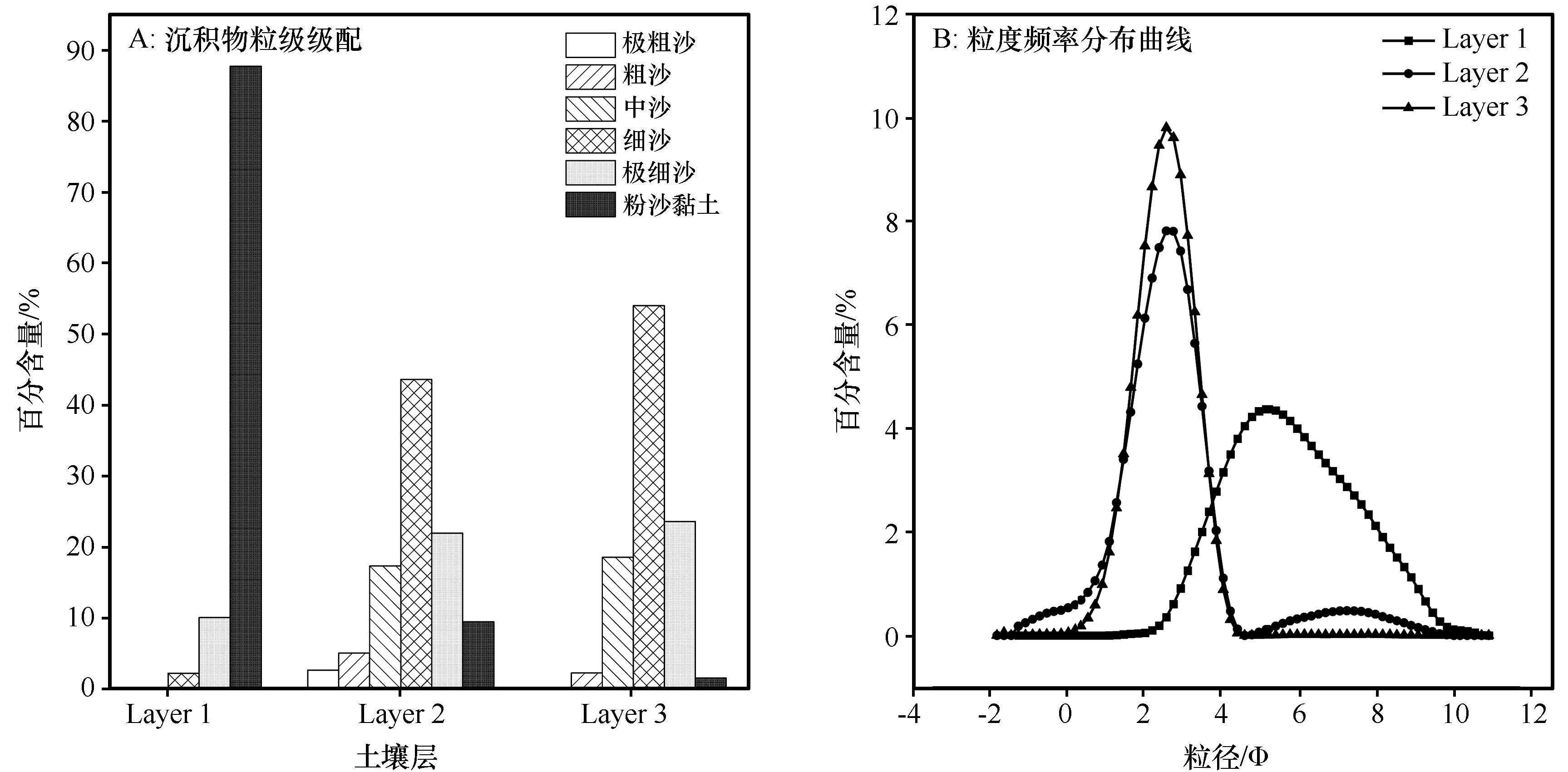
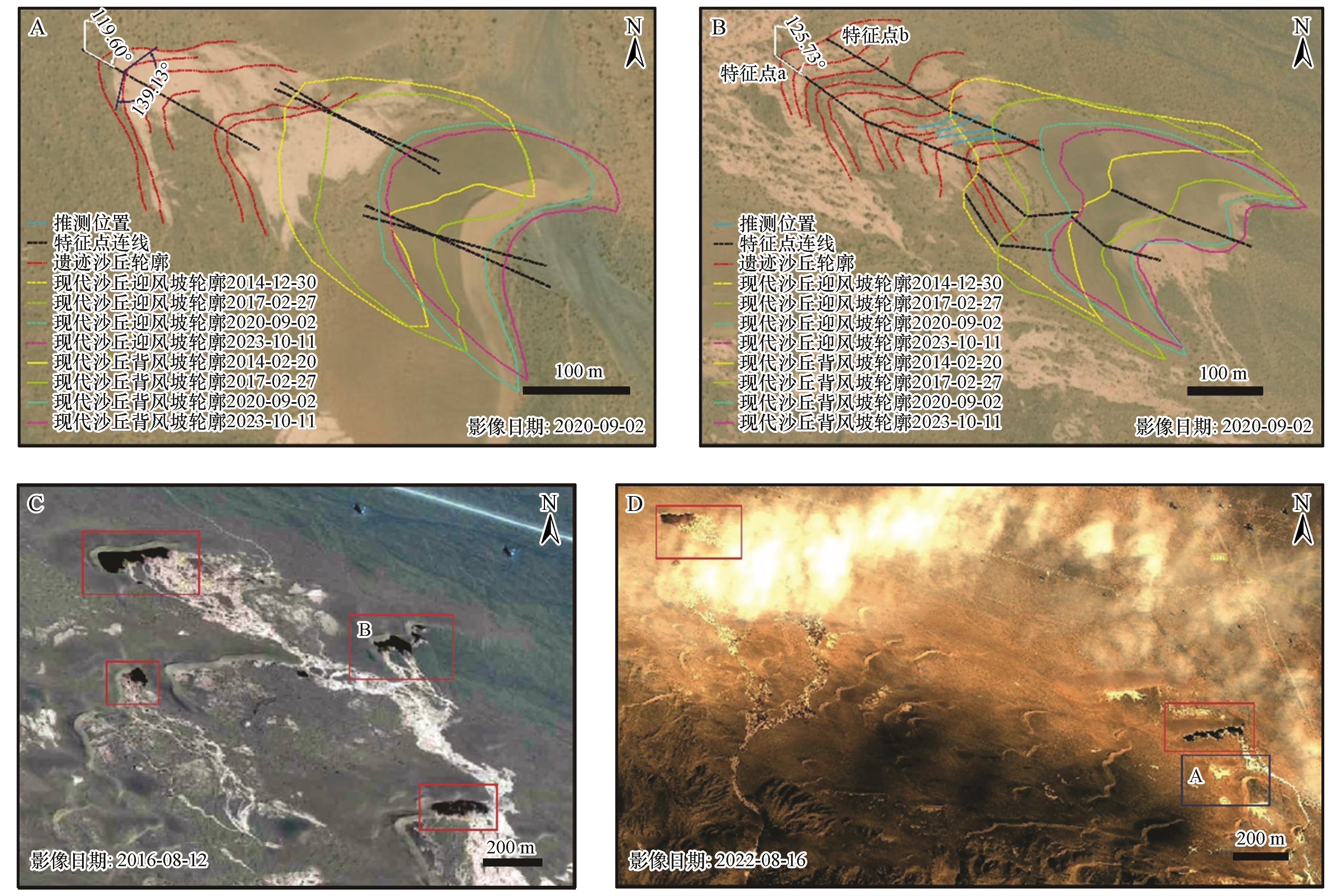
| 1 |
Clemmensen L B.Aeolian morphology preserved by lava cover,the Precambrian Mussartut Member,Eriksfjord Formation,South Greenland[J].Bulletin of the Geological Society of Denmark,1988,37:105-116.
|
| 2 |
Jerram D, Mountney N, Holzförster F,et al.Internal stratigraphic relationships in the Etendeka Group in the Huab Basin,NW Namibia:understanding the onset of flood volcanism[J].Journal of Geodynamics,1999,28:393-418.
|
| 3 |
Jerram D A, Mountney N, Stollhofen H.Facies architecture of the Etjo Sandstone formation and its interaction with the Basal Etendeka Flood Basalts of Northwest Namibia:implications for offshore prospectivity[J].Geological Society,London,Special Publications,1999,153(1):367-380.
|
| 4 |
Mountney N, Howell J, Flint S,et al.Aeolian and alluvial deposition within the Mesozoic Etjo Sandstone Formation,northwest Namibia[J].Journal of African Earth Sciences,1998,27(2):175-192.
|
| 5 |
Mountney N, Howell J, Flint S,et al.Relating eolian bounding-surface geometries to the bed forms that generated them:Etjo Formation,Cretaceous,Namibia[J].Geology,1999,27(2):159.
|
| 6 |
Jerram D A, Mountney N P, Howell J A,et al.Death of a sand sea:an active aeolian erg systematically buried by the Etendeka flood basalts of NW Namibia[J].Journal of the Geological Society,2000,157(3):513-516.
|
| 7 |
Banham S G, Gupta S, Rubin D M,et al.Ancient Martian aeolian processes and palaeomorphology reconstructed from the Stimson formation on the lower slope of Aeolis Mons,Gale crater,Mars[J].Sedimentology,2018,65(4):993-1042.
|
| 8 |
Waichel B L, Scherer C M S, Frank H T.Basaltic lava flows covering active aeolian dunes in the Paraná Basin in southern Brazil:features and emplacement aspects[J].Journal of Volcanology and Geothermal Research,2008,171(1):59-72.
|
| 9 |
Ahmed Benan C A, Kocurek G.Catastrophic flooding of an aeolian dune field:Jurassic Entrada and Todilto Formations,Ghost Ranch,New Mexico,USA[J].Sedimentology,2000,47(6):1069-1080.
|
| 10 |
Bandfield J L, Edgett K S, Christensen P R.Spectroscopic study of the Moses Lake dune field,Washington:determination of compositional distributions and source lithologies[J].Journal of Geophysical Research:Planets,2002,107(E11):2-1-2-15.
|
| 11 |
Day M D, Catling D C.Dune casts preserved by partial burial:the first identification of ghost dune pits on Mars[J].Journal of Geophysical Research:Planets,2018,123(6):1431-1448.
|
| 12 |
Gaylord D R, Rittenour T M, Link P K,et al.Ghost-dune hollows of the eastern Snake River Plain,Idaho:their genesis,evolution,and relevance to Martian ghost-dune pits[J].Geology,2021,49(8):899-904.
|
| 13 |
董治宝,李超,吕萍,等.侵蚀型沙丘:来自火星的启示[J].地球科学进展,2021,36(2):125-138.
|
| 14 |
Langford R P, Chan M A.Fluvial-aeolian interactions:part II,ancient systems[J].Sedimentology,1989,36(6):1037-1051.
|
| 15 |
Bullard J E, McTainsh G H.Aeolian-fluvial interactions in dryland environments:examples,concepts and Australia case study[J].Progress in Physical Geography:Earth and Environment,2003,27(4):471-501.
|
| 16 |
Liu B L, Coulthard T J.Mapping the interactions between rivers and sand dunes:implications for fluvial and aeolian geomorphology[J].Geomorphology,2014,231(February).
|
| 17 |
张钰.生态共同体视域下河西走廊生态治理研究[D].西安:陕西师范大学,2018.
|
| 18 |
朱秉启.中纬度荒漠区河西走廊沙丘地貌的演化特征及其环境指示[J].地理学报,2021,76(11):2710-2729.
|
| 19 |
Zhu B Q, Yu J J.Aeolian sorting processes in the Ejina desert basin (China) and their response to depositional environment[J].Aeolian Research,2014,12:111-120.
|
| 20 |
Zhang Z C, Dong Z B, Zhang C X,et al.The geochemical characteristics of dust material and dust sources identification in northwestern China[J].Journal of Geochemical Exploration,2017,175:148-155.
|
| 21 |
Zhang Z C, Dong Z B, Hu G Y,et al.Migration and morphology of asymmetric barchans in the central Hexi Corridor of Northwest China[J].Geosciences,2018,8(6):204.
|
| 22 |
Zhang H C, Ma Y Z, Peng J L,et al.Palaeolake and palaeoenvironment between 42 and 18 ka BP in Tengger Desert,NW China[J].Chinese Science Bulletin,2002,47:1946-1956.
|
| 23 |
Guan Q Y, Pan B T, Li N,et al.Timing and significance of the initiation of present day deserts in the northeastern Hexi Corridor,China[J].Palaeogeography,Palaeoclimatology,Palaeoecology,2011,306(1):70-74.
|
| 24 |
潘凯佳,张正偲,董治宝,等.河西走廊新月形沙丘表层沉积物的理化性质[J].中国沙漠,2019,39(1):44-51.
|
| 25 |
Folk R L, Ward W C.Brazos river bar:a study in the significance of grain size parameters[J].Journal of Sedimentary Petrology,1957,27(1):3-26.
|
| 26 |
Udden J A.Mechanical composition of clastic sediments[J].GSA Bulletin,1914,25(1):655-744.
|
| 27 |
Wentworth C K.A scale of grade and class terms for clastic sediments[J].The Journal of Geology,1922,30(5):377-392.
|
| 28 |
陈东雪,鲁瑞洁,丁之勇,等.青海湖湖东沙地河湖-风成沉积记录的中晚全新世以来环境变化[J].中国沙漠,2021,41(6):99-110.
|
| 29 |
杨岩岩,刘连友,屈志强,等.新月形沙丘研究进展[J].地理科学,2014,34(1):76-83.
|
| 30 |
McKee E D.Structures of dunes at White Sands National Monument,New Mexico (and a comparison with structures of dunes from other selected areas)1[J].Sedimentology,1966,7(1):3-69.
|
| 31 |
刘瑞,李志忠,靳建辉,等.古尔班通古特沙漠西南缘新月形沙丘内部沉积构造特征研究[J].干旱区地理,2022,45(3):802-813.
|
| 32 |
宋洁,春喜,白雪梅,等.中国沙漠粒度分析研究综述[J].中国沙漠,2016,36(3):597-603.
|
| 33 |
王晓枝,董治宝,南维鸽,等.拉萨河谷爬坡沙丘沉积物特征[J].中国沙漠,2022,42(4):22-31.
|
| 34 |
Visher G S.Grain size distributions and depositional processes[J].Journal of Sedimentary Research,1969,39(3):1074-1106.
|
| 35 |
袁星芳,徐昌,李方舟,等.山东省威海市刘公岛周边海域海底沉积物粒度特征及沉积动力环境研究[J].山东国土资源,2024,40(5):24-30.
|
| 36 |
Sahu B K.Depositional mechanisms from the size analysis of clastic sediments[J].Journal of Sedimentary Research,1964,34(1):73-83.
|
| 37 |
孟小楠,严平,董苗.爬坡沙丘的研究进展[J].北京师范大学学报(自然科学版),2018,54(3):391-396.
|
| 38 |
管超,哈斯额尔敦,周炎广,等.库布齐沙漠南缘风水交互特征及其对抛物线形沙丘发育的影响[J].中国沙漠,2018,38(5):899-908.
|
| 39 |
陈龙飞.三江源地区雪冰动态变化及其对流域水文过程的影响[D].北京:中国科学院大学(中国科学院空天信息创新研究院),2022.
|
| 40 |
初仕宾,韩集寿,李永良.甘肃嘉峪关黑山古代岩画[J].考古,1990(4):344-359,389-392.
|
 ), 陈颢, 肖锋军(

 甘公网安备 62010202000688号