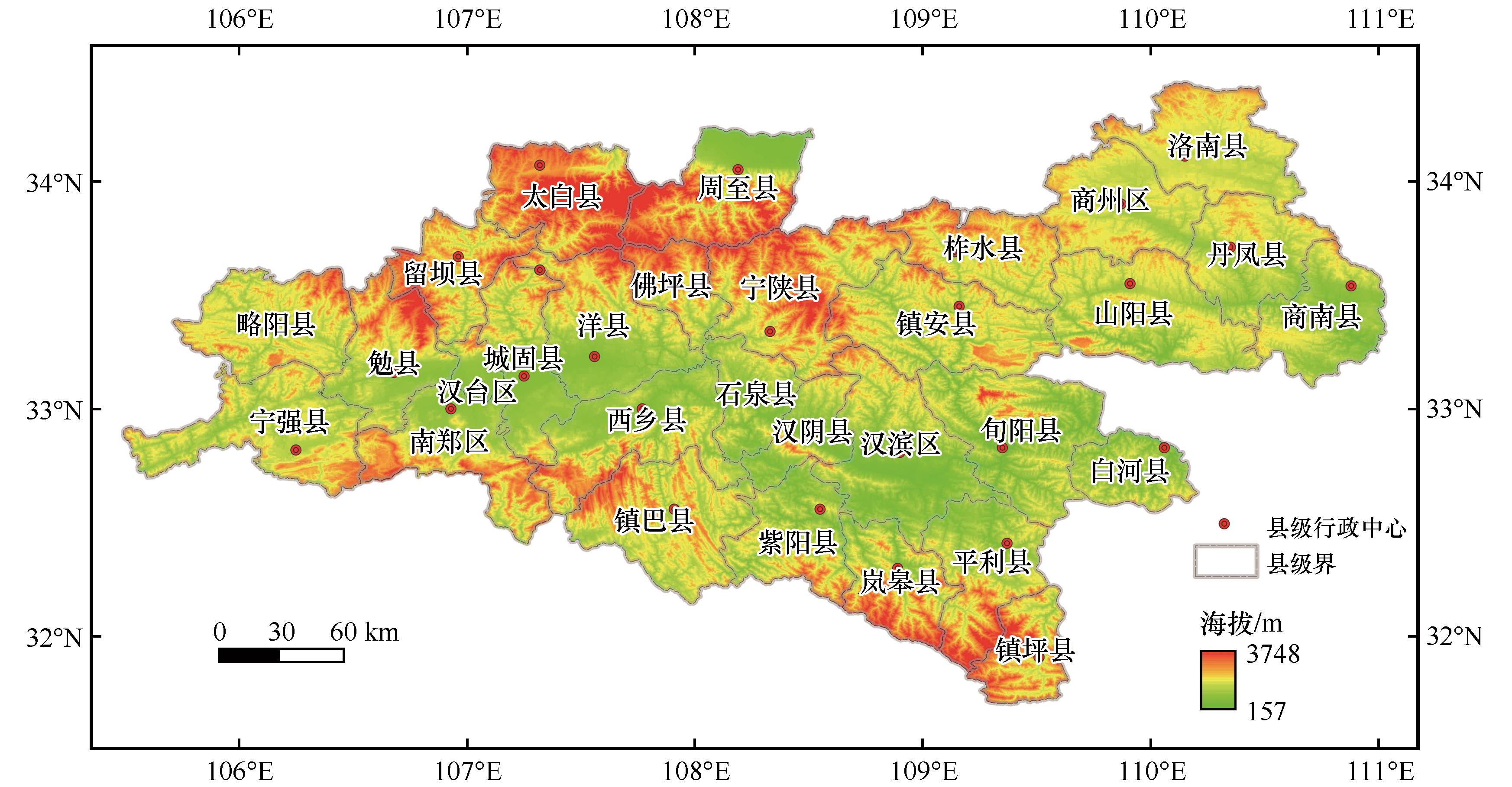
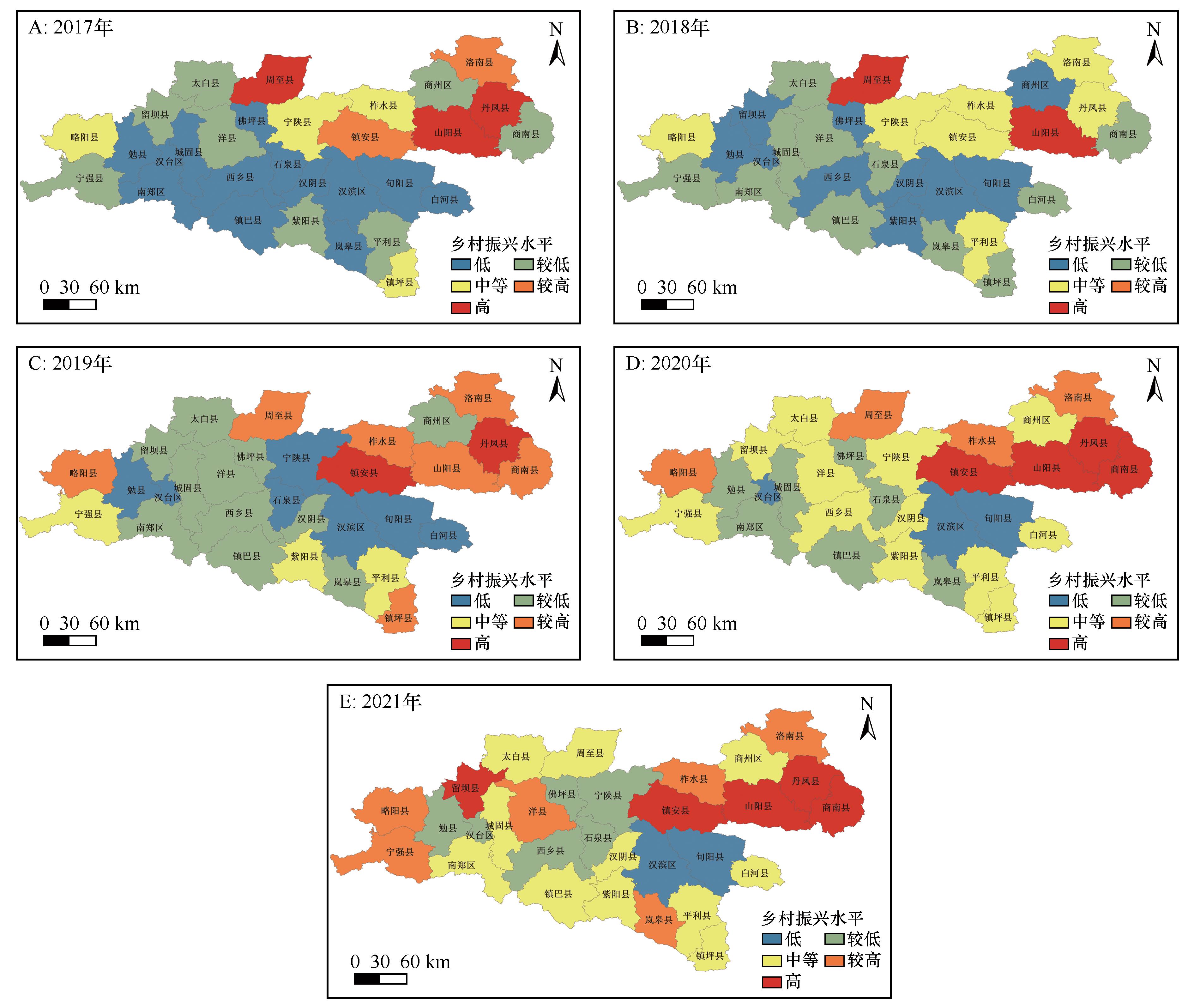
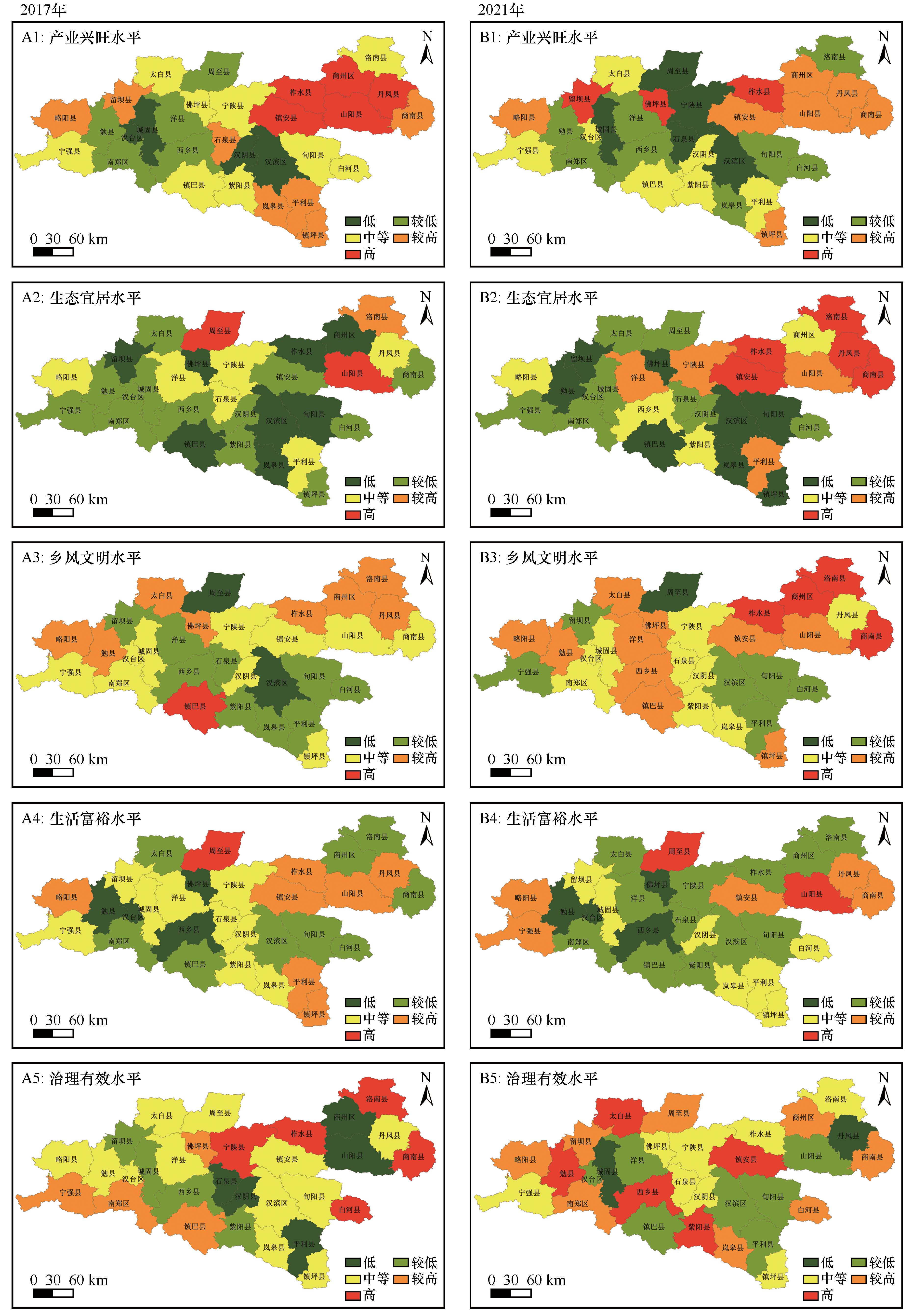
| [1] |
闫周府,吴方卫.从二元分割走向融合发展:乡村振兴评价指标体系研究[J].经济学家,2019(6):90-103.
|
| [2] |
张鹏,刘承.巩固拓展脱贫攻坚成果同乡村振兴有效衔接的逻辑机理与实现路径[J].改革与战略,2021,37(7):88-97.
|
| [3] |
李二玲,邓晴晴,何伟纯.基于产业集群发展的中部传统平原农区乡村振兴模式与实现路径[J].经济地理,2019,39(12):110-118.
|
| [4] |
Li Y, Fan P, Liu Y.What makes better village development in traditional agricultural areas of China?Evidence from long-term observation of typical villages[J].Habitat International,2019,83:111-124.
|
| [5] |
尹君锋,石培基.甘肃省县域乡村振兴发展评估与空间格局分异[J].中国沙漠,2022,42(5):1-9.
|
| [6] |
朱彩云.中央一号文件绘就乡村全面振兴“路线图”[N].中国青年报,2025-02-24(3).
|
| [7] |
苗俊霞,宋晓谕,冯人和,等.欠发达山区可持续发展目标相互作用研究:以云南省临沧市为例[J].地球科学进展,2022,37(9):949-962.
|
| [8] |
Romeo R V A T R.Mapping the vulnerability of mountain peoples to food insecurity[R].Rome,Italy:FAO,2015.
|
| [9] |
Pollermann K R P S G.Rural Development experiences in Germany:opportunities and obstacles in fostering smart places through LEADER[J].Studies in Agricultural Economics,2013,115(2):111-117.
|
| [10] |
Aubert F, Frère Q, Lépicier D,et al.Decentralization and rural development policies effectiveness:a quasi-experimental evaluation of the LEADER programme[J].Regional Studies,2025,59(1):2129606.
|
| [11] |
Georgios C, Nikolaos N, Michalis P.Neo-endogenous rural development:a path toward reviving rural Europe[J].Rural Sociology,2021(86):911-937.
|
| [12] |
Michalek J, Ciaian P, Di M F.Regional impacts of the EU rural development programme:poland's food processing sector[J].Regional Studies,2020,54(10):1389-1401.
|
| [13] |
Laidin C, Berriet-Solliec M.Understanding rural development policies:a proposal for a typology of the seven main policy repertoires in Europe and locally,based on French case studies[J].Annals of Regional Science,2022,71(4):121-144.
|
| [14] |
Makkonen T, Kahila P.Vitality policy as a tool for rural development in peripheral Finland[J].Growth and Change,2021,52(2):706-726.
|
| [15] |
曹斌.乡村振兴的日本实践:背景、措施与启示[J].中国农村经济,2018(8):117-129.
|
| [16] |
韩道铉,田杨.韩国新村运动带动乡村振兴及经验启示[J].南京农业大学学报(社会科学版),2019,19(4):20-27.
|
| [17] |
夏金梅.“三农”强富美:美国乡村振兴的实践及其经验借鉴[J].世界农业,2019(5):10-14.
|
| [18] |
Feng W, Liu Y, Qu L.Effect of land-centered urbanization on rural development:a regional analysis in China[J].Land Use Policy,2019,87:104072.
|
| [19] |
郭远智,周扬,刘彦随.贫困地区的精准扶贫与乡村振兴:内在逻辑与实现机制[J].地理研究,2019,38(12):2819-2832.
|
| [20] |
胡守庚,吴思,刘彦随.乡村振兴规划体系与关键技术初探[J].地理研究,2019,38(3):550-562.
|
| [21] |
乔陆印.乡村振兴村庄类型识别与振兴策略研究:以山西省长子县为例[J].地理科学进展,2019,38(9):1340-1348.
|
| [22] |
郭远智,刘彦随.中国乡村发展进程与乡村振兴路径[J].地理学报,2021,76(6):1408-1421.
|
| [23] |
姜长云.实施乡村振兴战略需努力规避几种倾向[J].农业经济问题,2018(1):8-13.
|
| [24] |
贾晋,李雪峰,申云.乡村振兴战略的指标体系构建与实证分析[J].财经科学,2018(11):70-82.
|
| [25] |
韩欣宇,闫凤英.乡村振兴背景下乡村发展综合评价及类型识别研究[J].中国人口·资源与环境,2019,29(9):156-165.
|
| [26] |
郑兴明.基于分类推进的乡村振兴潜力评价指标体系研究:来自福建省3县市6个村庄的调查数据[J].社会科学,2019(6):36-47.
|
| [27] |
易小燕,陈印军,向雁,等.县域乡村振兴指标体系构建及其评价:以广东德庆县为例[J].中国农业资源与区划,2020,41(8):187-195.
|
| [28] |
张晓杰,刘芳清,刘静波,等.村域乡村振兴评价指标体系构建:以津市市金鱼岭街道大关山村为例[J].安徽农业科学,2021,49(7):212-214.
|
| [29] |
万红莲,毛楠,宋海龙,等.基于县域尺度的榆林市农业生态系统脆弱性空间演变研究[J].江西农业学报,2021,33(10):131-137.
|
| [30] |
尹君锋,石培基,张韦萍,等.乡村振兴背景下县域农业农村创新发展评价及空间格局:以甘肃省为例[J].自然资源学报,2022,37(2):291-306.
|
| [31] |
李雪敏,李同宁,李道政,等.内蒙古县域生态系统服务与居民福祉耦合协调关系时空特征及影响因素研究[J].干旱区资源与环境,2023,37(7):27-37.
|
| [32] |
刘海娇,范明元,管清花,等.县域“四水四定”协调性评价及应用[J].干旱区资源与环境,2023,37(4):194-200.
|
| [33] |
倪敬峰,张翀,赵昕.陕西省县域旅游景点空间分异与影响机制研究[J].干旱区资源与环境,2022,36(3):202-208.
|
| [34] |
吕承超,崔悦.乡村振兴发展:指标评价体系、地区差距与空间极化[J].农业经济问题,2021(5):20-32.
|
| [35] |
毛锦凰.乡村振兴评价指标体系构建方法的改进及其实证研究[J].兰州大学学报(社会科学版),2021,49(3):47-58.
|
| [36] |
万红莲,毛楠,宋海龙,等.基于三角图法的榆林市农业生态系统脆弱性类型变化研究[J].中国沙漠,2021,41(3):224-234.
|
| [37] |
龚晓菊,臧杨杨.乡村振兴与我国县域产业发展路径:浙江范例研究[J].生态经济,2022,38(9):111-117.
|
| [38] |
化祥雨,金祥荣,吕海萍,等.高质量发展耦合协调时空格局演化及影响因素:以浙江省县域为例[J].地理科学,2021,41(2):223-231.
|
| [39] |
文琦,郑殿元.西北贫困地区乡村类型识别与振兴途径研究[J].地理研究,2019,38(3):509-521.
|
| [40] |
张玉,王介勇,刘彦随.陕西秦巴山区地域功能转型与高质量发展路径[J].自然资源学报,2021,36(10):2464-2477.
|
 ), 万红莲1(
 甘公网安备 62010202000688号