img

官方微信

高级检索

中国沙漠 ›› 2021, Vol. 41 ›› Issue (2): 83-91.DOI: 10.7522/j.issn.1000-694X.2020.00136

• • 上一篇    下一篇

蒙古东部野火时空格局及其影响因素

徐书兴1(), 吴倩倩1, 乔殿学2, 穆英林2, 张晓1, 刘艳书1, 杨晓晖1, 时忠杰1()   

  1. 1.中国林业科学研究院 荒漠化研究所,北京 100091
    2.内蒙古维纳河自然保护区管理局,内蒙古 鄂温克自治旗 021100
  • 收稿日期:2020-10-21 修回日期:2020-12-27 出版日期:2021-03-20 发布日期:2021-03-26
  • 通讯作者: 时忠杰
  • 作者简介:时忠杰 (E-mail: shijie1204@163.com)
    徐书兴(1994—),男,山东青岛人,硕士研究生,研究方向为遥感数据处理和生态环境遥感。E-mail: xsxkytjl@163.com
  • 基金资助:
    科技基础资源调查专项课题(2017FY101301);国家重点研发计划课题(2016YFC0500908);国家自然科学基金项目(31670715)

Spatiotemporal pattern and effecting factors of wildfire in eastern Mongolia

Shuxing Xu1(), Qianqian Wu1, Dianxue Qiao2, Yinglin Mu2, Xiao Zhang1, Yanshu Liu1, Xiaohui Yang1, Zhongjie Shi1()   

  1. 1.Institute of Desertification Studies,Chinese Academy of Forestry Sciences,Beijing 100091,China
    2.Administration of Weina River Nature Reserve of Inner Mongolia,Ewenki Autonomous Banner 021100,Inner Mongolia,China
  • Received:2020-10-21 Revised:2020-12-27 Online:2021-03-20 Published:2021-03-26
  • Contact: Zhongjie Shi

摘要:

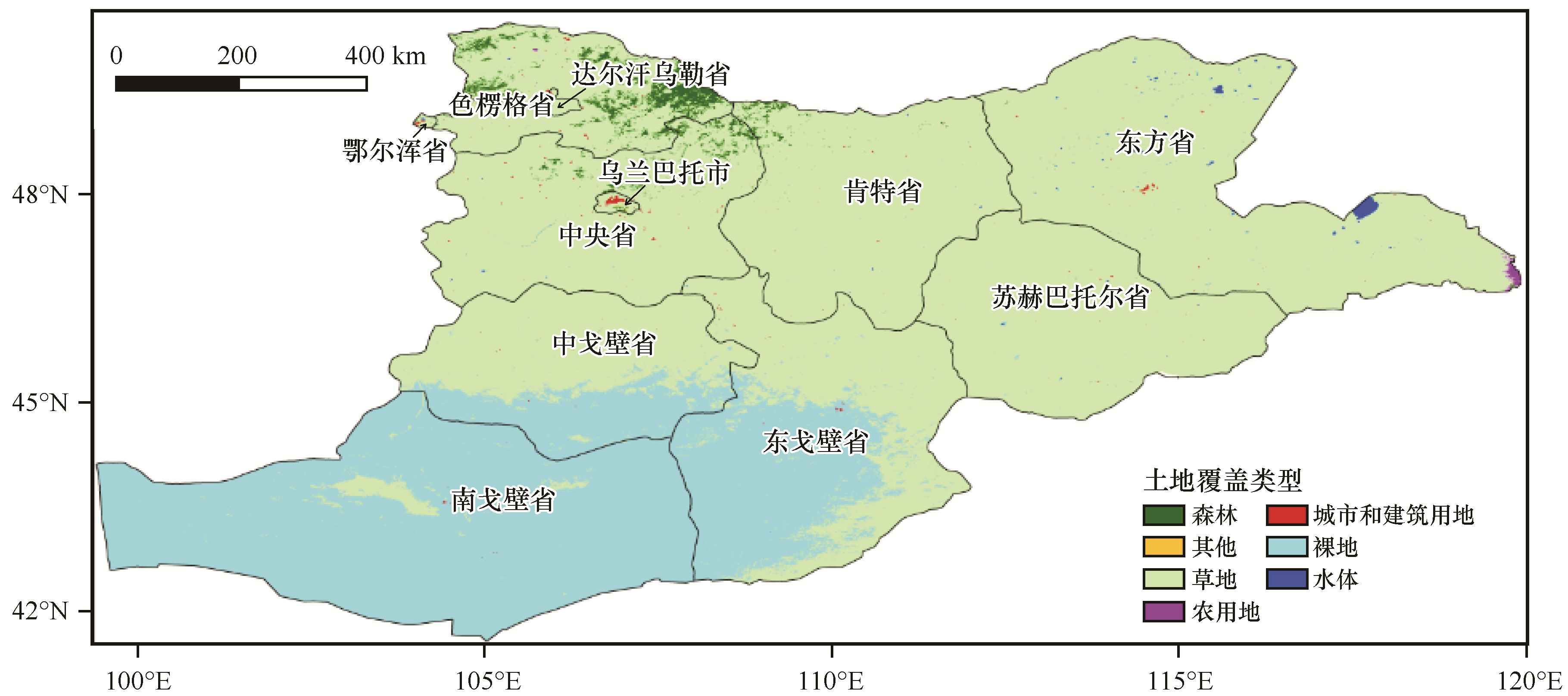
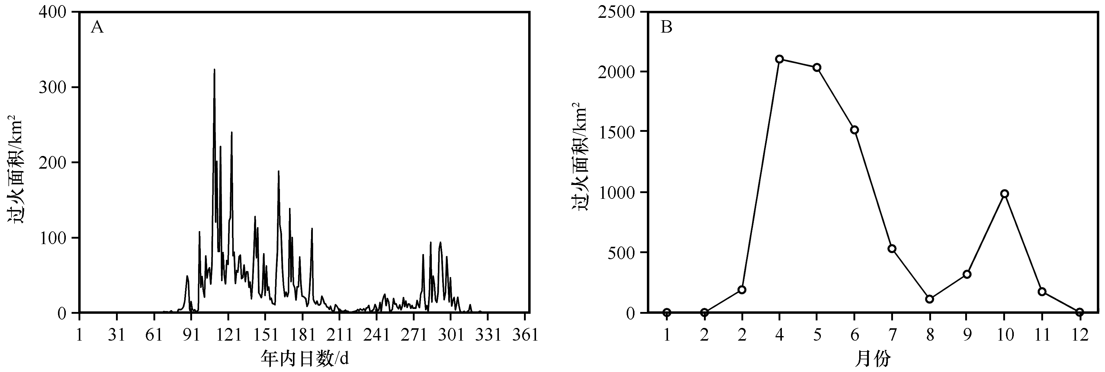
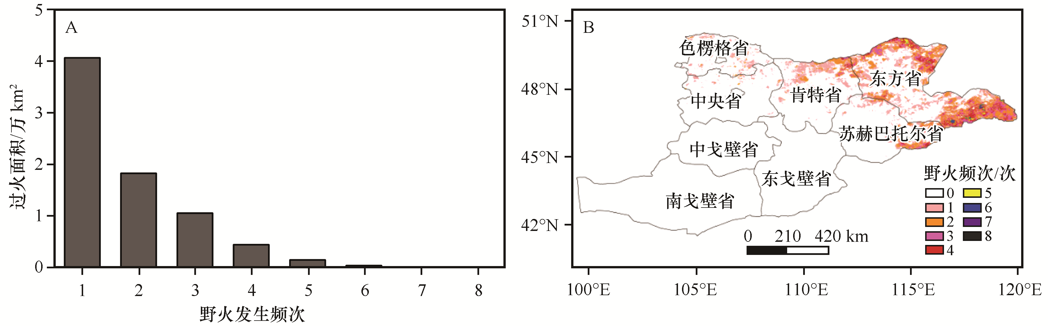
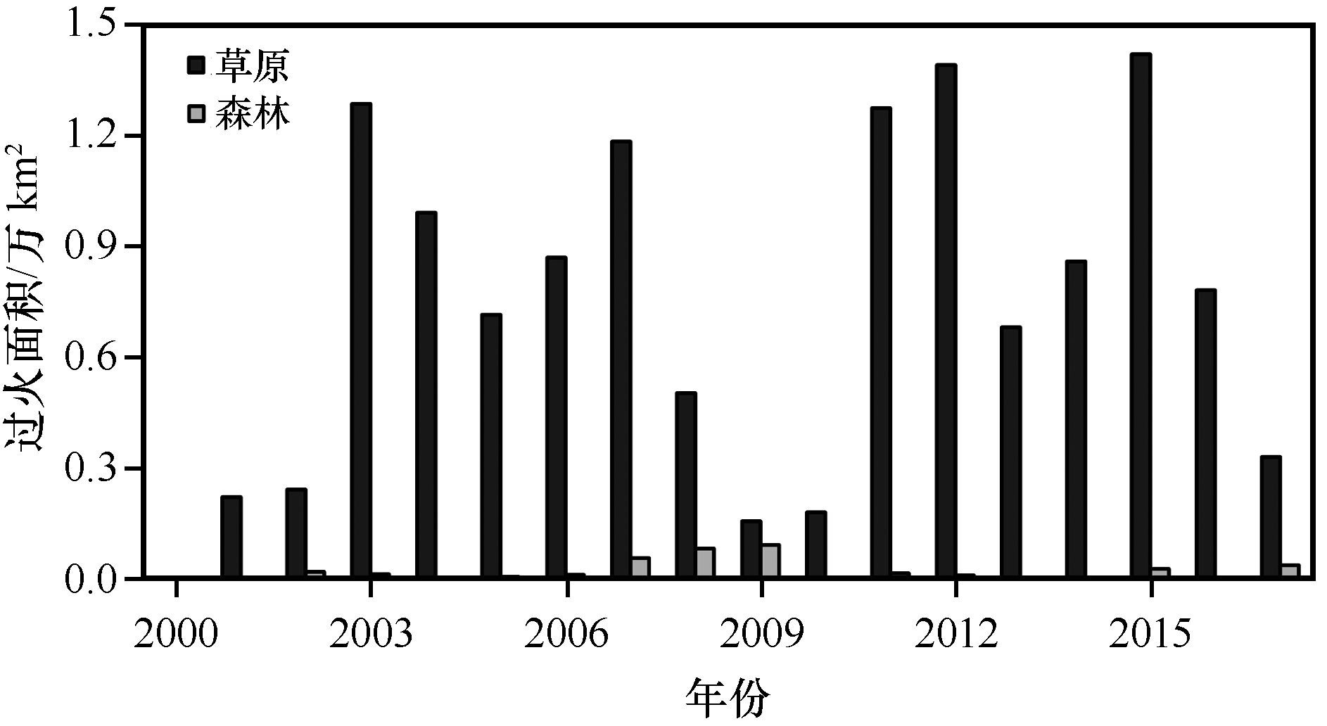
基于MCD64A1过火迹地产品、土地覆盖、植被指数和气候等数据,采用空间统计分析和相关分析方法研究了2001—2017年蒙古东部野火时空动态及其影响因素。结果表明:(1)4—6月是野火发生最主要的时段,10月野火灾害也较严重,特别集中于年内第107—127、145—189、279—301日3个时段;2001—2017年,蒙古东部野火过火面积年际间波动较大,2003、2007、2011、2012、2015年是野火发生的高峰年。(2)从野火发生的空间格局看,野火灾害主要发生在东方、肯特、苏赫巴托尔、色楞格、中央省;草原火是蒙古东部主要的过火类型。(3)过火面积主要受降水、温度和植被状况影响;3月过火面积主要与3个月累积的干旱状况有关,而6、7月过火面积主要与当月温度相关,9月过火面积主要受当月降水量影响;在季节尺度上,春季过火面积还与前一年秋季植被状况显著相关,冬季过火面积与当季地表温度呈显著正相关。(4)大气环流与蒙古东部的野火发生、蔓延密切相关,4月过火面积主要受3个月累积北极涛动影响,7月过火面积主要受3个月累积太平洋十年涛动影响,9月过火面积主要受火前北大西洋涛动影响,而11月过火面积主要受3个月累积南方涛动和太平洋十年涛动影响。年尺度上的过火面积主要受北大西洋涛动显著影响。

关键词: 野火, 时空动态, 影响因素, 大气环流, 蒙古

Abstract:

The spatial and temporal dynamics and influencing factors of wildfires in eastern Mongolia from 2001 to 2017 were studied by using the method of spatial statistical and correlation analysis. The results show that: (1) The wildfires mainly occurred from April to June, and the wildfires is also serious in October. Within a year, the wildfires occur mainly in the three periods: 107-127,145-189 and 279-301 of the day of year. From 2001 to 2017, the area of wildfire in eastern Mongolia fluctuated greatly from year to year, and the peak years of wildfire occurred in 2003, 2007, 2011, 2012 and 2015; (2)Wildfire mainly occurs in Dornod, Kent, Sukhbator, Selengge and Central provinces; Grassland wildfires were the main type in eastern Mongolia;(3)The area of wildfire is mainly affected by precipitation, air temperature and vegetation. The burned areas in March is positively correlated with the drought of the three months, and the burned area in June and July is positively correlated with the temperature of the current month, while the burned area in September is negatively correlated with the precipitation of the current month; In addition, the fire area in spring was significantly related to the vegetation in the autumn of the previous year, and the fire area in winter was significantly related to the temperature in the current season; (4)The wildfires in this area were closely affected by the atmospheric circulation in the eastern part of Mongolia. The burned area is negatively related to the average Arctic Oscillation (AO) accumulated in three months in April, and in July, the burned area is positively related to the average North Pacific decadal Oscillation (PDO) accumulated in three months. There was a significant negative correlation between the area of fire in September and the average North Atlantic Oscillation (NAO) accumulated in three months. There was a significant negative correlation between the fire area in November and the accumulated average Southern Oscillation Index (SOI) in three months, and a significant positive correlation between the over fire area and the accumulated average North Pacific decadal Oscillation (PDO) in three months. The burned area on the annual scale is significantly affected by NAO.

Key words: wildfire, spatiotemporal dynamics, influence factors, atmospheric circulation, Mongolia

中图分类号: