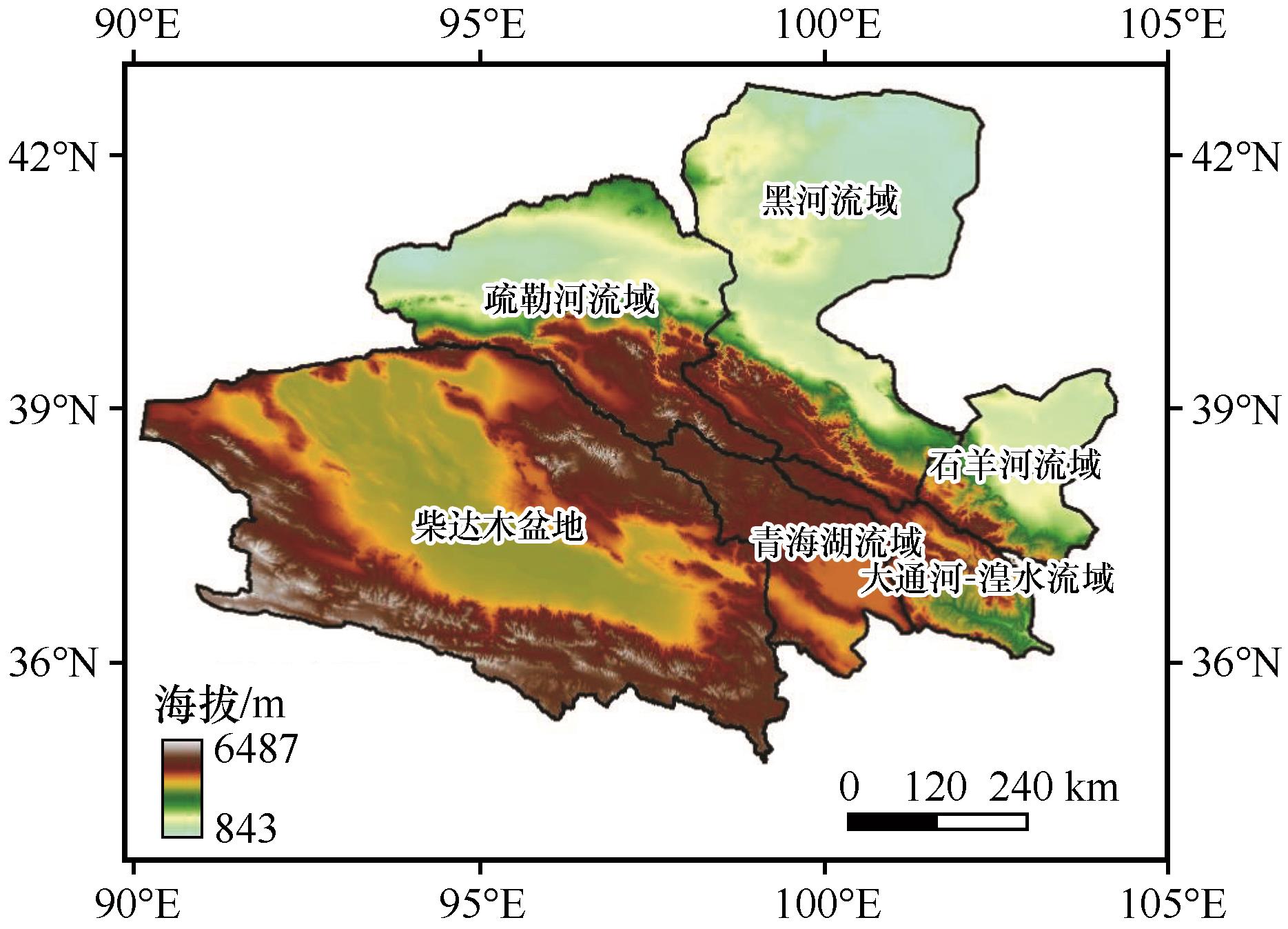
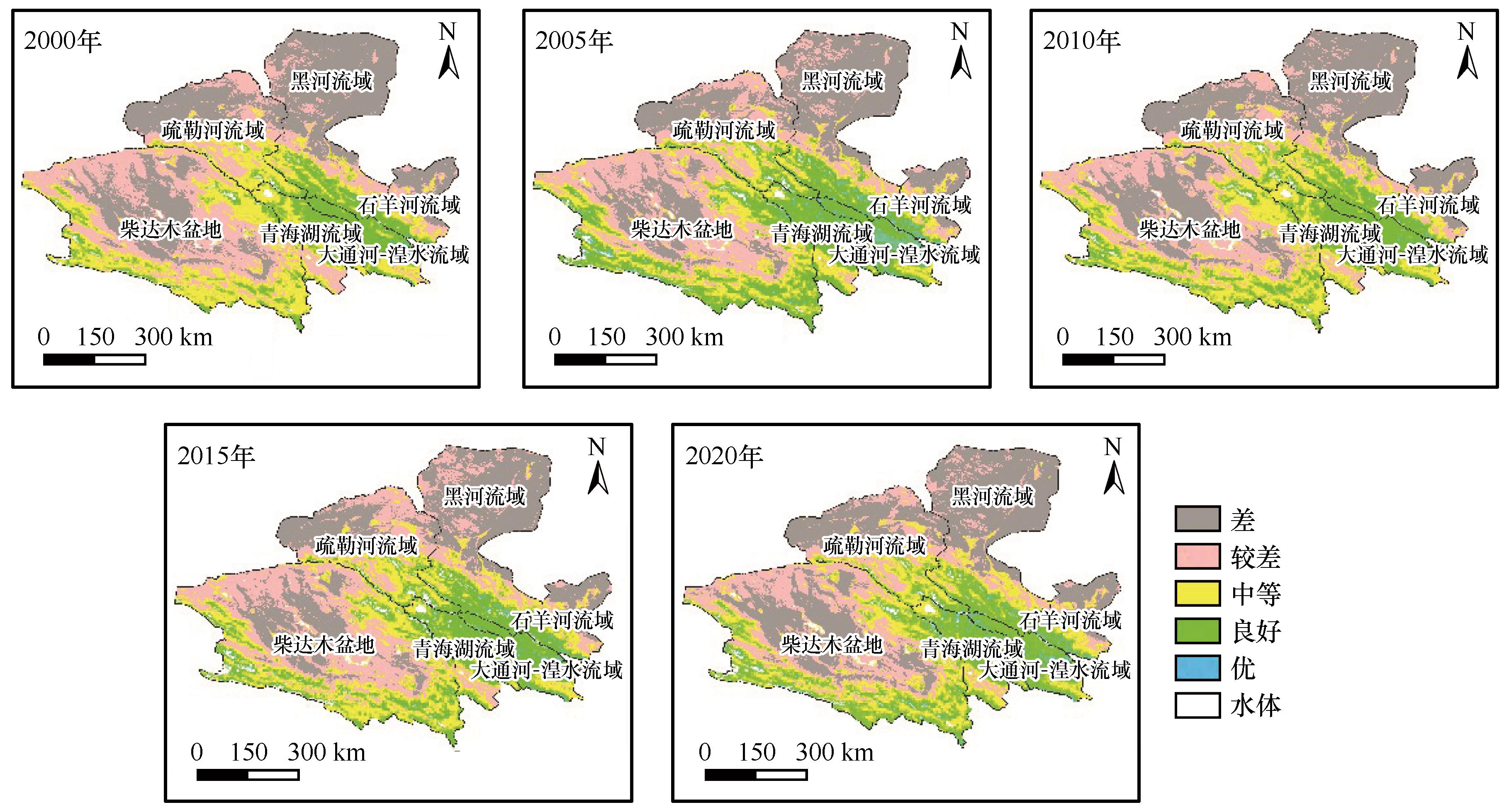
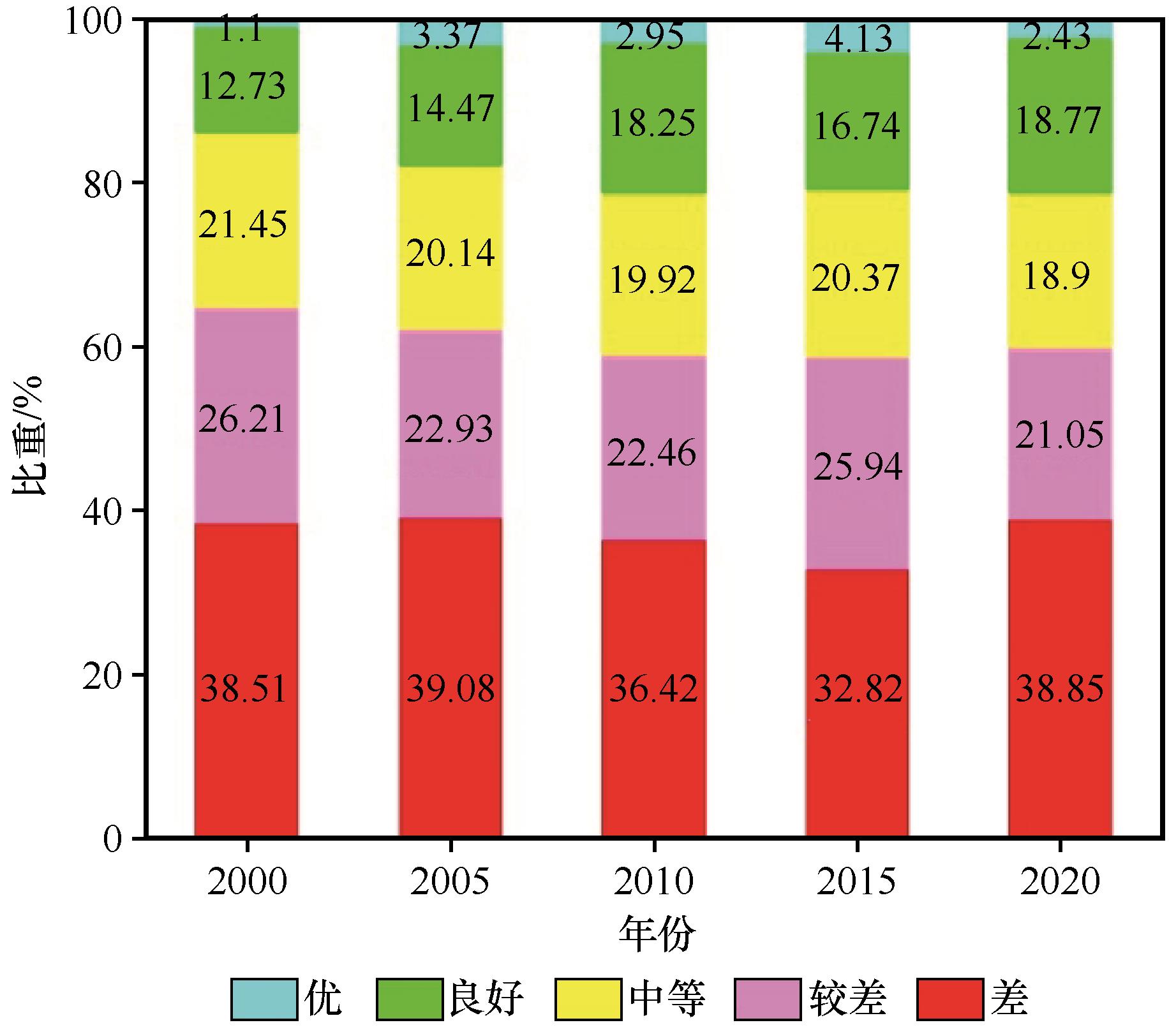
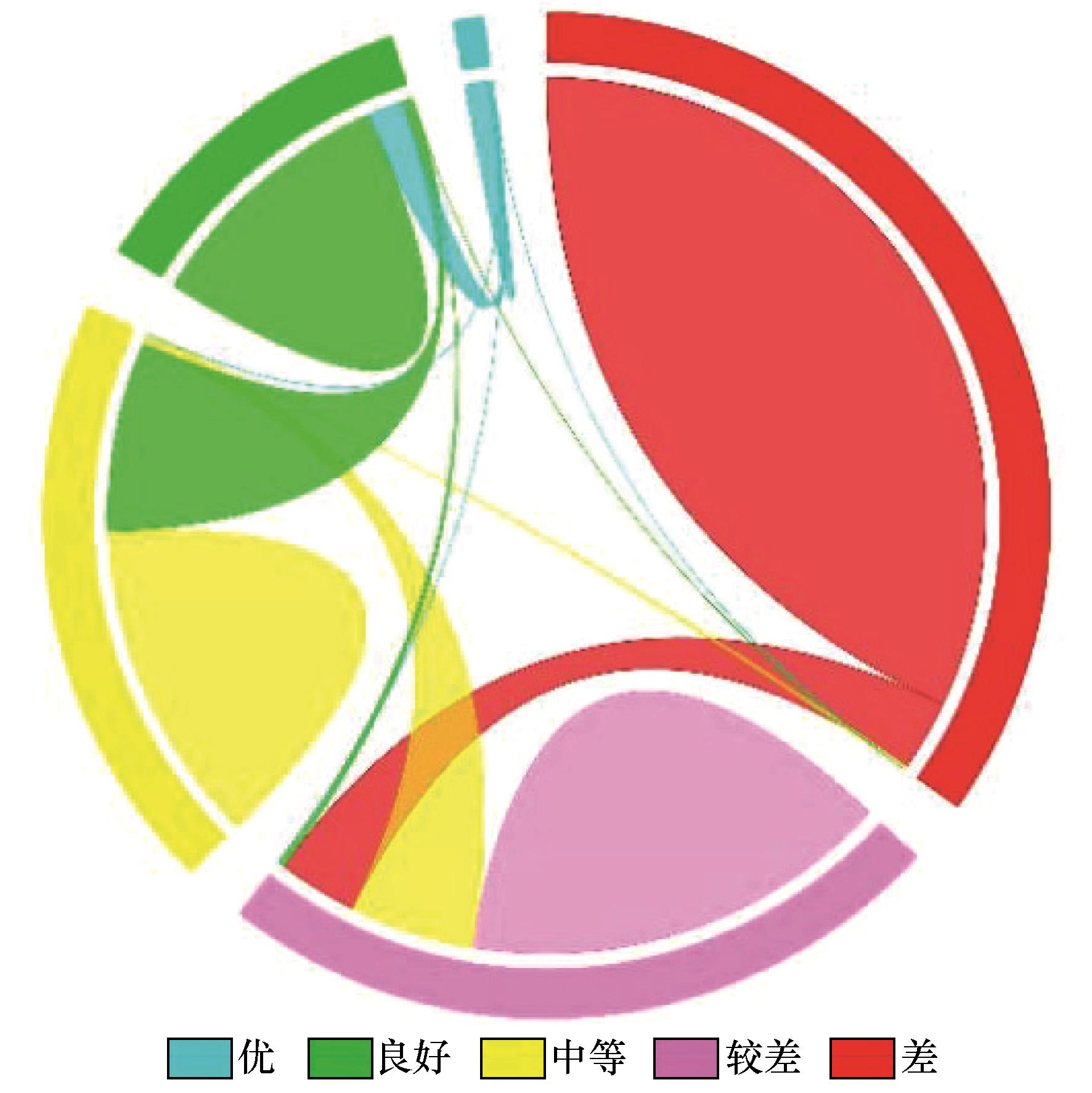
| 1 |
赵其国,黄国勤,马艳芹.中国生态环境状况与生态文明建设[J].生态学报,2016,36(19):6328-6335.
|
| 2 |
Wu X, Fu B, Wang S,et al.Decoupling of SDGs followed by re-coupling as sustainable development progresses[J].Nature Sustainability,2022,5(5):452-459.
|
| 3 |
Li J L, Lu X F, Zhang J J,et al.The current status,problems and prospects of researches on the carrying capacities of ecological environment in China[J].Journal of Resources and Ecology,2019,10(6):605-613.
|
| 4 |
Lu Y, Kong F, Huang L,et al.Evaluation of the implementation effect of the ecological compensation policy in the Poyang Lake River Basin based on Difference-in-Difference Method [J].Sustainability,2021,13(15):8667.
|
| 5 |
张华, 宋金岳, 李明,等.基于GEE的祁连山国家公园生态环境质量评价及成因分析[J].生态学杂志,2021,40(6):1883-1894.
|
| 6 |
Ge Y C, Li X, Cheng G,et al.What dominates sustainability in endorheic regions?[J].Science Bulletin,2022,67(16):1636-1640.
|
| 7 |
王涛,高峰,王宝,等.祁连山生态保护与修复的现状问题与建议[J].冰川冻土,2017,39(2):229-234.
|
| 8 |
Mulder V L, de Bruin S, Schaepman M E,et al.The use of remote sensing in soil and terrain mapping:a review[J].Geoderma,2011,162(1):1-19.
|
| 9 |
张沛,徐海量,杜清,等.综合治理前后和田河流域生态环境状况变化及原因探讨[J].水土保持研究,2016,23(4):174-178.
|
| 10 |
Xu H Q.A remote sensing index for assessment of regional ecological changes[J].China Environmental Science,2013,33(5):889-897.
|
| 11 |
Xu H Q.Remote sensing urban ecological index and its application[J].Acta Ecologica Sinica,2013,33(24):7853-7862.
|
| 12 |
Wang S, Yingchun G.Ecological quality response to multi-scenario land-use changes in the Heihe River Basin[J].Sustainability,2022,14(5):2716.
|
| 13 |
程志峰,何祺胜.基于RSEI的苏锡常城市群生态环境遥感评价[J].遥感技术与应用,2019,34(3):531-539.
|
| 14 |
杨泽康,田佳,李万源,等.黄河流域生态环境质量时空格局与演变趋势[J].生态学报,2021,41(19):7627-7636.
|
| 15 |
Gorelick N, Hancher M, Dixon M,et al.Google Earth Engine: planetary-scale geospatial analysis for everyone[J].Remote Sensing of Environment,2017,202(3):18-27.
|
| 16 |
张静,杨丽萍,贡恩军,等.基于Google Earth Engine和改进型遥感生态指数的西安市生态环境质量动态监测[J].生态学报,2023,43(5):1-14.
|
| 17 |
王劲峰,徐成东.地理探测器:原理与展望[J].地理学报,2017,72(1):116-134.
|
| 18 |
辛龙,孙慧,王慧,等.基于地理探测器的绿色经济效率时空分异及驱动力研究[J].中国人口·资源与环境,2020,30(9):128-138.
|
| 19 |
Zeng W, Wan X, Lei M,et al.Influencing factors and prediction of arsenic concentration in Pteris vittata:a combination of geodetector and empirical models[J].Environmental Pollution,2022,292:118240.
|
| 20 |
Wang H, Zhou S, Li X,et al.The influence of climate change and human activities on ecosystem service value[J].Ecological Engineering,2016,87:224-239.
|
| 21 |
Xu H.Modification of normalised difference water index (NDWI) to enhance open water features in remotely sensed imagery[J].International Journal of Remote Sensing,2006,27(14):3025-3033.
|
| 22 |
杨磊,单姝瑶,桑晨,等.祁连山国家公园生态环境质量综合评价及演变特征分析[J].草业科学,2022,39(2):278-289.
|
| 23 |
李鑫磊,李瑞平,王秀青,等.基于地理探测器的河套灌区林草植被覆盖度时空变化与驱动力分析[J].干旱区研究,2023,40(4):623-635.
|
| 24 |
郑子豪,吴志峰,陈颖彪,等.基于 Google Earth Engine 的长三角城市群生态环境变化与城市化特征分析[J].生态学报,2021,41(2):717-729.
|
| 25 |
高思琦,董国涛,蒋晓辉,等.基于地理探测器的三江源植被变化及自然驱动因子分析[J].水土保持研究,2022,29(4):336-343.
|
| 26 |
童威, 郎丰铠.基于地理探测器的武汉市土地利用变化及其驱动机制探讨[J].水利水电技术,2021,52(4):45-56.
|
| 27 |
刘莉,汪丽娜.基于地理探测器的广东省水资源利用效率影响因素研究[J].水电能源科学,2021,39(4):40-43.
|
| 28 |
王蕊,拜得珍,尹芳,等.湟水流域2000-2019年植被变化趋势特征和延续性分析[J].遥感技术与应用,2022,37(6):1504-1512.
|
| 29 |
韩艳莉.气候与景观格局变化对青海湖流域生态系统服务的影响[D].西宁:青海师范大学,2021.
|
| 30 |
Chen F, Xie T, Yang Y,et al.Discussion of the “warming and wetting” trend and its future variation in the drylands of Northwest China under global warming[J].Science China Earth Sciences,2023,66(6):1241-1257.
|
| 31 |
魏伟.基于CLUE-S和MCR模型的石羊河流域土地利用空间优化配置研究[D].兰州:兰州大学,2018.
|
| 32 |
乔雪梅,刘普幸,任媛,等.基于遥感的黑河流域生态环境变化特征及成因分析[J].中国环境科学,2020,40(9):3962-3971.
|
| 33 |
Hoek van Dijke A J, Herold M, Mallick K,et al.Shifts in regional water availability due to global tree restoration[J].Nature Geoscience,2022,15(5):363-368.
|
| 34 |
徐彩瑶,王苓,潘丹,等.退耕还林高质量发展生态补偿机制创新实现路径[J].林业经济问题,2022,42(1):9-20.
|
| 35 |
李广英,赵生奎.青海湖流域生态环境保护与经济社会可持续发展对策[J].环境科学与技术,2008(2):148-151.
|
| 36 |
陈丽红,刘普幸,花亚萍.基于RSEI的疏勒河流域生态质量综合评价及其成因分析[J].土壤通报,2021,52(1):25-33.
|
| 37 |
张旺雄,刘普幸.1961-2017年柴达木盆地干湿状况及其影响因子[J].干旱区研究,2019,36(6):1391-1400.
|
| 38 |
杨荣金,舒俭民,李秀红,等.柴达木盆地生态环境保护战略与对策[J].科技导报,2017,35(6):115-119.
|
| 39 |
张伟,杜培军,郭山川,等.改进型遥感生态指数及干旱区生态环境评价[J].遥感学报,27(2):299-317.
|
| 40 |
罗镕基,王宏涛,王成.基于改进遥感生态指数的甘肃省古浪县生态质量评价[J].干旱区地理,2023,46(4):539-549.
|
| 41 |
黄莹,包安明,陈曦,等.基于绿洲土地利用的区域GDP公里格网化研究[J].冰川冻土,2009,31(1):162-169.
|
 ), 盖迎春2(
 甘公网安备 62010202000688号