| 1 |
Lall U, Josset L, Russo T.A Snapshot of the world's groundwater challenges[J].Annual Review of Environment and Resources,2020,45(1):171-194.
|
| 2 |
陈雪萍,赵学勇,王瑞雄,等.气候变化与土地利用/覆被变化对中国北方农牧交错带水资源影响研究进展[J].中国沙漠,2022,42(3):170-177.
|
| 3 |
王思佳,刘鹄,赵文智,等.干旱、半干旱区地下水可持续性研究评述[J].地球科学进展,2019,34(2):210-223.
|
| 4 |
Torres-garcía M T, Oyonarte C, Cabello J,et al.The potential of groundwater-dependent ecosystems to enhance soil biological activity and soil fertility in drylands[J].Science of The Total Environment,2022,826:154111.
|
| 5 |
尹立河,张俊,王哲,等.西北内陆河流域地下水循环特征与地下水资源评价[J].中国地质,2021,48(4):1094-1111.
|
| 6 |
丁宏伟,张荷生.近50年来河西走廊地下水资源变化及对生态环境的影响[J].自然资源学报,2002(6):691-697.
|
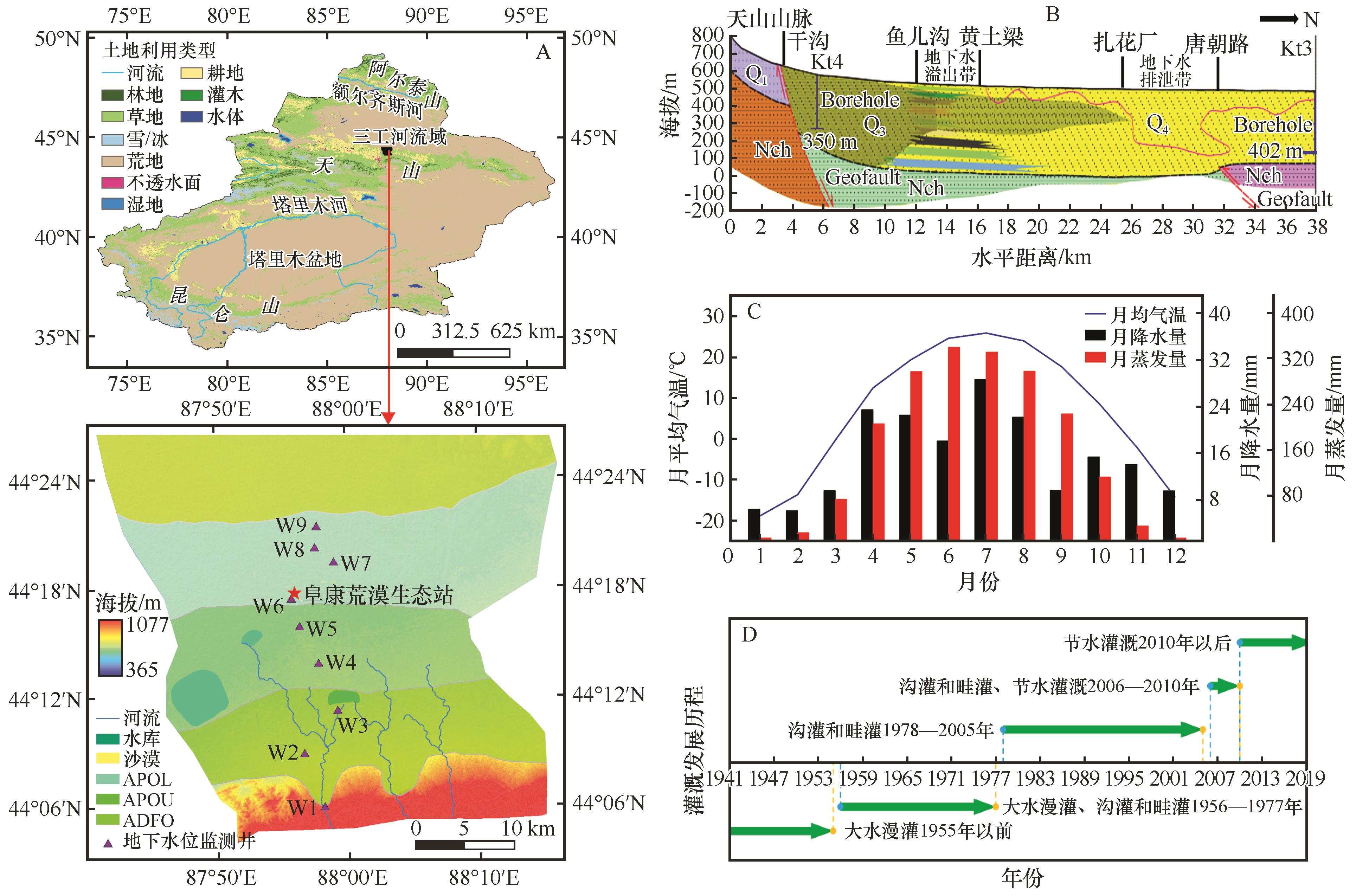
| 7 |
李元寿,贾晓红,鲁文元.西北干旱区水资源利用中的生态环境问题及对策[J].水土保持研究,2006(1):217-219+242.
|
| 8 |
樊自立,马英杰,艾力西尔·库尔班,等.试论中国荒漠区人工绿洲生态系统的形成演变和可持续发展[J].中国沙漠,2004,24(1):12-18.
|
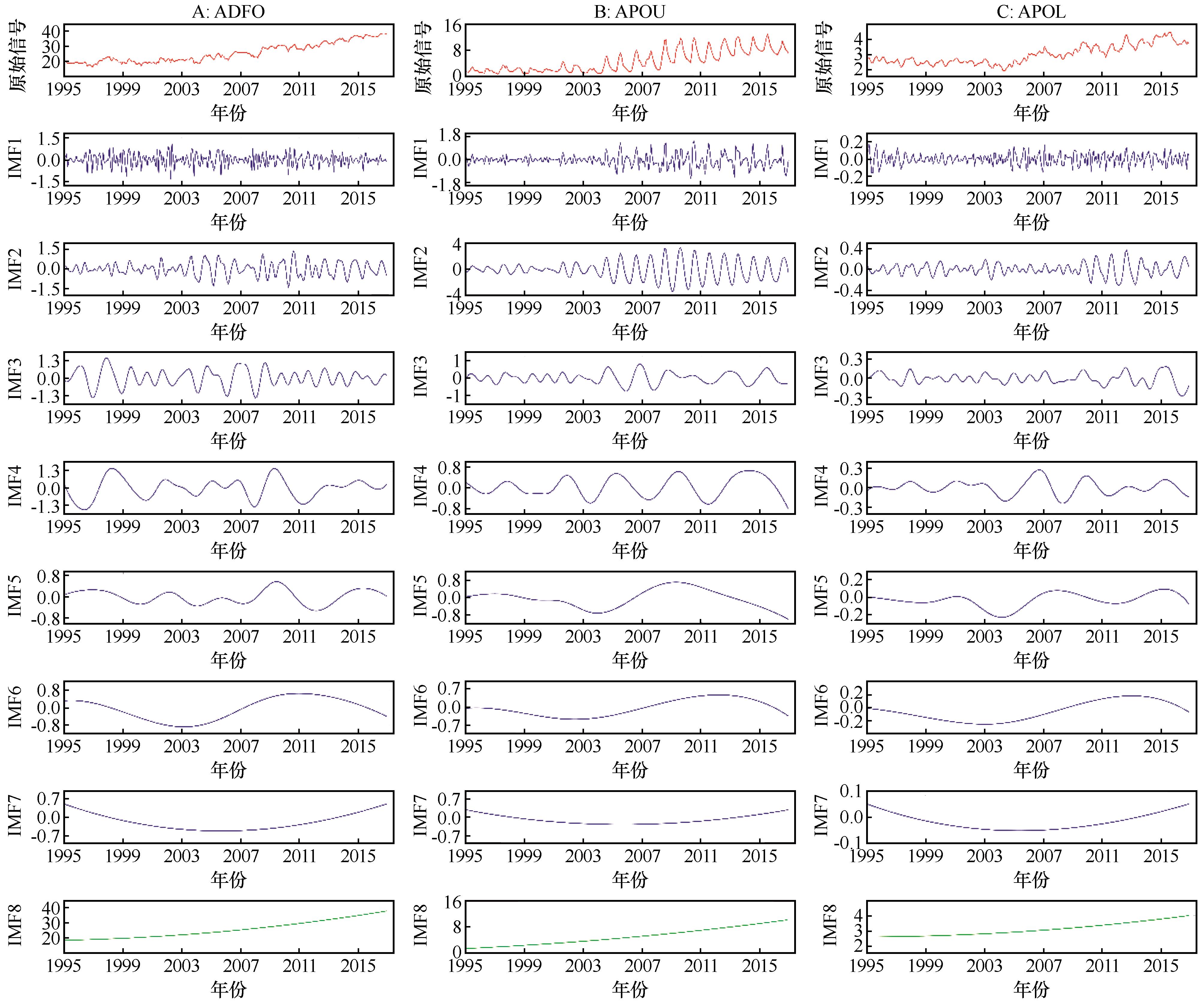
| 9 |
孙青言,郭辉,陆垂裕.地下水动态演变研究现状与发展趋势[J].灌溉排水学报,2021,40():58-64.
|
| 10 |
吴彬,杜明亮,穆振侠,等.1956-2016年新疆平原区地下水资源量变化及其影响因素分析[J].水科学进展,2021,32(5):659-669.
|
| 11 |
高宇阳,杨鹏年,阚建,等.人类活动影响下乌苏市地下水埋深演化趋势[J].灌溉排水学报,2019,38(10):90-96.
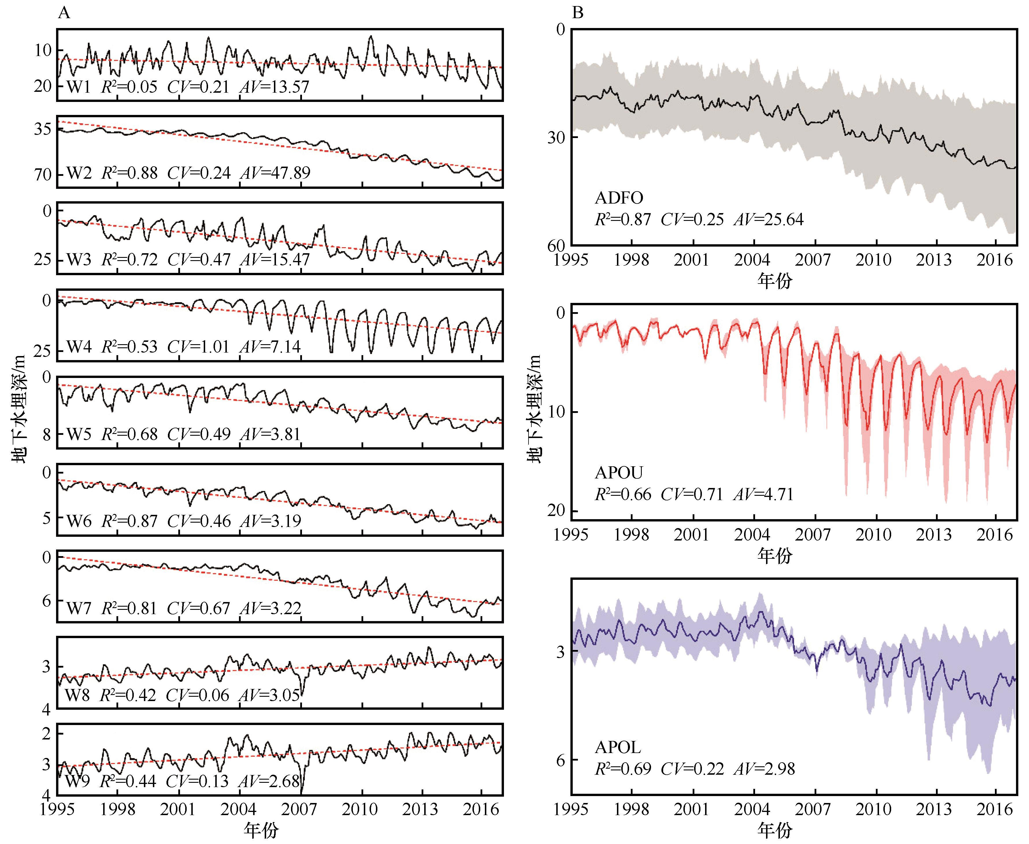
|
| 12 |
阮永健,吴秀芹.基于GRACE和GLDAS的西北干旱区地下水资源量可持续性评价[J].干旱区研究,2022,39(3):787-800.
|
| 13 |
Li D B, Li X L, He X L,et al.Groundwater dynamic characteristics with the ecological threshold in the northwest China oasis[J].Sustainability,2022,14(9):5390.
|
| 14 |
邵光成,章坤,王志宇,等.基于IABC-RBF神经网络的地下水埋深预测模型[J].浙江大学学报(工学版),2019,53(7):1323-1330.
|
| 15 |
Chen C, He W, Zhou H,et al.A comparative study among machine learning and numerical models for simulating groundwater dynamics in the Heihe River Basin,northwestern China[J].Scientific Reports,2020,10:3904.
|
| 16 |
Jasechko S, Seybold H, Perrone D,et al.Rapid groundwater decline and some cases of recovery in aquifers globally[J].Nature,2024,625:715-721.
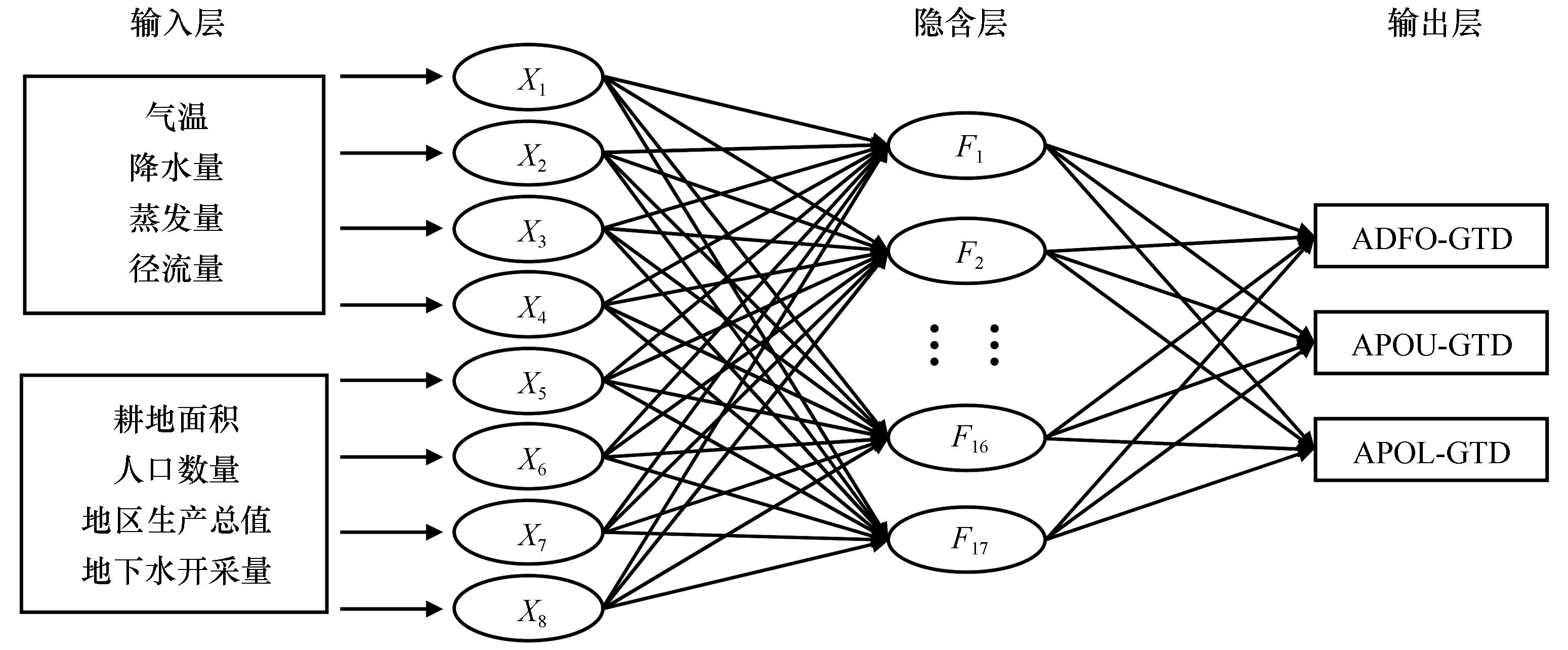
|
| 17 |
Kuang X X, Liu J G, Scanlon B R,et al.The changing nature of groundwater in the global water cycle[J].Science,2024,383(6686):962.
|
| 18 |
肖鲁湘,罗格平,陈曦,等.干旱区冲洪积扇-冲积平原绿洲浅层地下水质时空变化初步分析:以三工河流域绿洲为例[J].干旱区地理,2005(2):225-228.
|
| 19 |
王玉朝,赵成义.三工河流域景观格局的形成与环境分异特征[J].水土保持学报,2001(3):98-101.
|
| 20 |
尚海敏,王文科,段磊,等.天山北麓地下水基于生态水位的调控模拟分析[J].水土保持研究,2014,21(6):144-147.
|
| 21 |
闫金凤,陈曦,罗格平,等.绿洲浅层地下水位与水质变化对人为驱动LUCC的响应:以三工河流域为例[J].自然资源学报,2005(2):172-180.
|
| 22 |
陆晴,刘丽娟,王玉刚,等.新疆三工河流域农业绿洲近30年景观格局变化及其驱动力[J].生态学杂志,2013,32(3):748-754.
|
| 23 |
年福华,李新.三工河流域水量转换特征及水资源利用[J].干旱区研究,2000,17(1):5-11.
|
| 24 |
Wu Z H, Huang N E.Ensemble empirical mode decomposition:a noise-assisted data analysis method[J].Advances in Adaptive Data Analysis,2009,1(1):1-41.
|
| 25 |
罗那那,巴特尔·巴克,吴燕锋.基于集合经验模态分解北疆降水多尺度变化特征[J].水土保持研究,2017,24(4):362-367.
|
| 26 |
张应华,宋献方.水文气象序列趋势分析与变异诊断的方法及其对比[J].干旱区地理,2015,38(4):652-665.
|
| 27 |
常耀文,吴一晗,刘霞,等.基于小波分析的荒漠草原土壤湿度周期变化特征[J].中国草地学报,2023,45(9):87-97.
|
| 28 |
束龙仓,徐丽丽,袁亚杰,等.三江平原典型区地下水流场变化及主要影响因素分析[J].水利学报,2022,53(6):644-654.
|
| 29 |
Deng J L.Control problems of grey systems[J].Systems & Control Letters,1982,1(5):288-294.
|
| 30 |
卫磊,杨桂莲,鲁程鹏,等.华北平原超采区浅层地下水埋深变化及控制因素分析[J].水资源与水工程学报,2019,30(6):39-44.
|
| 31 |
黄洲.“三条红线”条件下兵团第八师退地减水对水土资源影响及综合评估[D].石河子:石河子大学,2023.
|
| 32 |
刘海丽,齐善忠,刘丽娟,等.基于地统计的新疆阜康绿洲地下水埋深空间异质性[J].生态学杂志,2018,37(5):1484-1489.
|
| 33 |
管春兴,张虹波,王战,等.玛纳斯河流域山前平原区地下水资源动态变化分析[J].水利水电技术,2019,50(3):1-9.
|
| 34 |
吉磊,刘兵,何新林,等.玛纳斯河下游灌区地下水埋深变化特征及成因分析[J].灌溉排水学报,2015,34(9):59-65.
|
| 35 |
刘志明,王贵玲,蔺文静.石羊河流域平原地下水位动态特征与监测网观测频率优化[J].中国沙漠,2006,26(1):85-89.
|
| 36 |
陈社明,卢文喜,罗建男,等.内蒙古德岭山地区灌溉农业发展对浅层地下水系统演化的影响[J].农业工程学报,2012,28(3):1-7.
|
| 37 |
丁启振,周金龙,杜明亮,等.新疆石河子-昌吉地区2016-2020年地下水位动态特征分析[J].灌溉排水学报,2022,41(2):109-117.
|
| 38 |
米丽娜,肖洪浪,朱文婧,等.1985-2013年黑河中游流域地下水位动态变化特征[J].冰川冻土,2015,37(2):461-469.
|
| 39 |
宋子奕,鲁程鹏,吴成城,等.2009-2019年河西走廊地下水位时空分布及演变趋势[J].水资源保护,2023,39(2):160-167.
|
| 40 |
崔佳琪,李仙岳,史海滨,等.节水改造前后永济灌域地下水环境时空变化特征[J].干旱区研究,2022,39(3):841-852.
|
| 41 |
陈彬鑫,何新林,杨丽莉,等.莫索湾灌区近22年来地下水埋深变化及影响因素分析[J].干旱区资源与环境,2020,34(12):155-160.
|
| 42 |
陈泽,吴彬,高凡,等.2011-2020年新疆鄯善县地下水位时空动态变化规律[J].水土保持通报,2023,43(2):60-68.
|
| 43 |
陈永金,艾克热木·阿布拉,张天举,等.塔里木河下游生态输水对地下水埋深变化的影响[J].干旱区地理,2021,44(3):651-658.
|
| 44 |
张震域,赵沛,畅祥生,等.额济纳绿洲1992-2015年地下水埋深变化分析[J].人民黄河,2019,41(7):33-37.
|
| 45 |
缑天宇,佟玲,康德奎,等.中国西北干旱区石羊河流域重点治理综合效应评价[J].农业工程学报,2022,38(12):74-84.
|
| 46 |
杨怀德,冯起,郭小燕.1999-2013年民勤绿洲地下水埋深年际变化动态及影响因素[J].中国沙漠,2017,37(3):562-570.
|
| 47 |
刘媛媛,刘业森,郑敬伟,等.BP神经网络和数值模型相结合的城市内涝预测方法研究[J].水利学报,2022,53(3):284-295.
|
| 48 |
薛萍,张召,雷晓辉,等.基于BP神经网络的不同时间尺度泵站前池水位预测模型[J].南水北调与水利科技(中英文),2022,20(2):393-407.
|
| 49 |
王虹,魏秉炎,王昊云.基于主成分分析的BP神经网络模型在铁矿产地溯源中的应用[J].冶金分析,2021,41(9):11-17.
|
| 50 |
杜云皓,仇锦先,冯绍元.改进GA-BP模型在地下水位埋深预测中的应用[J].节水灌溉,2017(9):81-84.
|
| 51 |
陈曦,夏军,钱静,等.三工河流域分布式水文模型研究[J].干旱区地理,2003,26(4):305-308.
|
| 52 |
张叶,刘兵,何新林,等.干旱灌区地下水位动态变化及驱动因素分析[J].节水灌溉,2017(6):63-67.
|
| 53 |
魏兴,贾瑞亮,周金龙,等.新疆玛纳斯河流域典型剖面地下水位动态分析[J].南水北调与水利科技,2017,15(5):127-133.
|
| 54 |
李彦,郑新军,王玉刚,等.绿洲-荒漠共生关系实验模拟平台(绿洲-荒漠平台)[J].中国科学院院刊,2021,36(12):1506-1514.
|
 ), 黄彩霞1(

 甘公网安备 62010202000688号