
- CN 62-1070/P
- ISSN 1000-694X
- Bimonthly 1981
Journal of Desert Research ›› 2021, Vol. 41 ›› Issue (5): 51-61.DOI: 10.7522/j.issn.1000-694X.2021.00048
Previous Articles Next Articles
Kailu Liu1( ), Xinping Wu2, Yongqiang Liu1(), Mamtimin Ali3, Fan Yang3, Qing He4
Received:2021-02-09
Revised:2021-04-25
Online:2021-09-20
Published:2021-09-23
Contact:
Yongqiang Liu
CLC Number:
Kailu Liu, Xinping Wu, Yongqiang Liu, Mamtimin Ali, Fan Yang, Qing He. Estimation of hourly surface net radiation in Taklimakan Desert based on multi-source remote sensing data and reanalysis data[J]. Journal of Desert Research, 2021, 41(5): 51-61.
Add to citation manager EndNote|Ris|BibTeX
URL: http://www.desert.ac.cn/EN/10.7522/j.issn.1000-694X.2021.00048
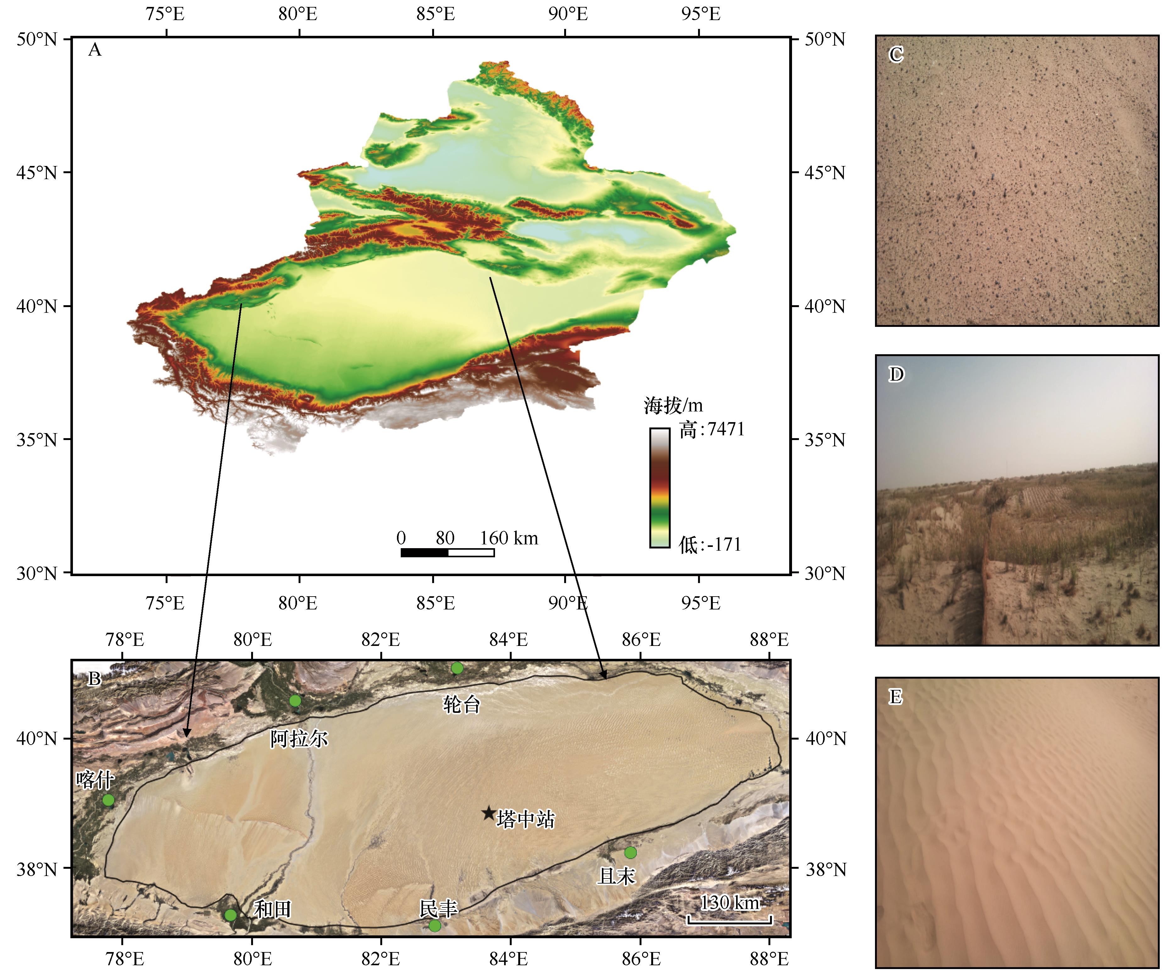
Fig.1 General situation of the study area
| 数据项 | 数据来源 | 空间 分辨率 | 时间 分辨率 | 数据 格式 |
|---|---|---|---|---|
| 地表温度LST | FY-2F | 0.1°×0.1° | 1 h | AWX |
| 地表比辐射率εs | MOD11C1 | 1 km | 1 d | TIFF |
| MOD11A1 | 1 km | |||
| MOD09GA | 500 m | |||
| 地表反照率α | MOD09GA | 500 m | 1 d | TIFF |
| 向下短波辐射Rswd | CMFD | 0.1°×0.1° | 3 h | NC |
| 空气温度Ta | CMFD | 0.1°×0.1° | 3 h | NC |
Table 1 Summary of the input datasets used for calculating daily surface net radiation
| 数据项 | 数据来源 | 空间 分辨率 | 时间 分辨率 | 数据 格式 |
|---|---|---|---|---|
| 地表温度LST | FY-2F | 0.1°×0.1° | 1 h | AWX |
| 地表比辐射率εs | MOD11C1 | 1 km | 1 d | TIFF |
| MOD11A1 | 1 km | |||
| MOD09GA | 500 m | |||
| 地表反照率α | MOD09GA | 500 m | 1 d | TIFF |
| 向下短波辐射Rswd | CMFD | 0.1°×0.1° | 3 h | NC |
| 空气温度Ta | CMFD | 0.1°×0.1° | 3 h | NC |
| 观测项目 | 仪器型号 | 时间分辨率 |
|---|---|---|
| 风速、风向 | Metone 010/020C | 30 min |
| 空气温、湿度 | Vaisala HMP45C | 30 min |
| 辐射四分量观测仪 | Kipp&Zonen CNR-1 | 30 min |
Table 2 The survey of land surface energy detections system in Tazhong station
| 观测项目 | 仪器型号 | 时间分辨率 |
|---|---|---|
| 风速、风向 | Metone 010/020C | 30 min |
| 空气温、湿度 | Vaisala HMP45C | 30 min |
| 辐射四分量观测仪 | Kipp&Zonen CNR-1 | 30 min |
| 评价指标 | 公式 | 理想值 |
|---|---|---|
| 决定系数 (R2) | 1 | |
| 均方根误差 (RMSE) | 0 | |
| 平均绝对误差 (MAE) | 0 | |
| 模拟效率 (EF) | 1 |
Table 3 Statistical indices used for performance evaluation of input variables and in situ data
| 评价指标 | 公式 | 理想值 |
|---|---|---|
| 决定系数 (R2) | 1 | |
| 均方根误差 (RMSE) | 0 | |
| 平均绝对误差 (MAE) | 0 | |
| 模拟效率 (EF) | 1 |
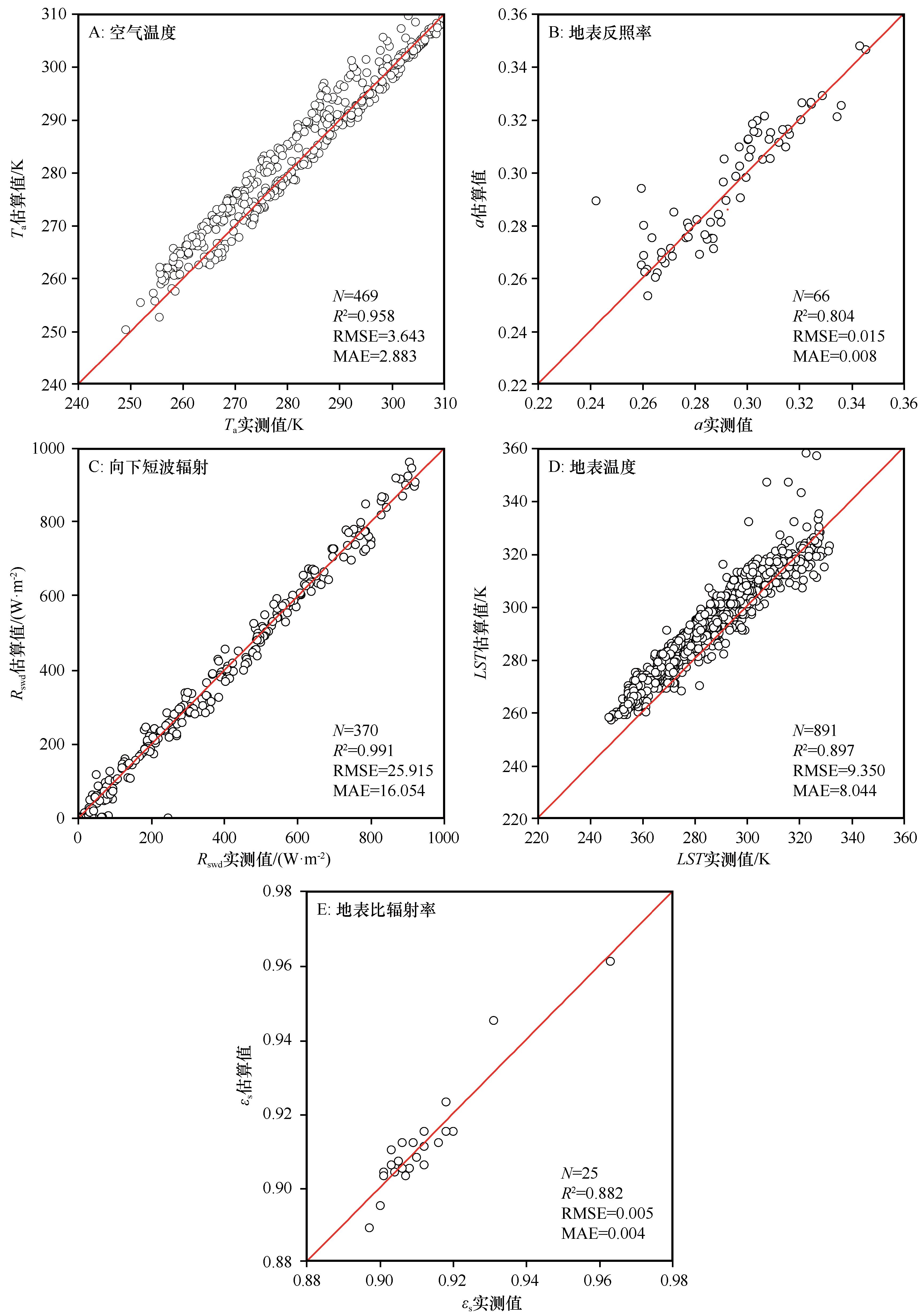
Fig.2 Comparison of the variables between CMFD, FY-2F, MODIS and ground observation
| 参数 | R2 | RMSE | MAE | EF |
|---|---|---|---|---|
| Ta/K | 0.985 | 3.643 | 2.883 | 0.936 |
| α | 0.804 | 0.015 | 0.008 | 0.878 |
| Rswd /(W?m-2) | 0.991 | 25.915 | 16.054 | 0.991 |
| LST/K | 0.897 | 9.350 | 8.044 | 0.762 |
| εs | 0.882 | 0.005 | 0.004 | 0.864 |
Table 4 Errors of input parameters
| 参数 | R2 | RMSE | MAE | EF |
|---|---|---|---|---|
| Ta/K | 0.985 | 3.643 | 2.883 | 0.936 |
| α | 0.804 | 0.015 | 0.008 | 0.878 |
| Rswd /(W?m-2) | 0.991 | 25.915 | 16.054 | 0.991 |
| LST/K | 0.897 | 9.350 | 8.044 | 0.762 |
| εs | 0.882 | 0.005 | 0.004 | 0.864 |
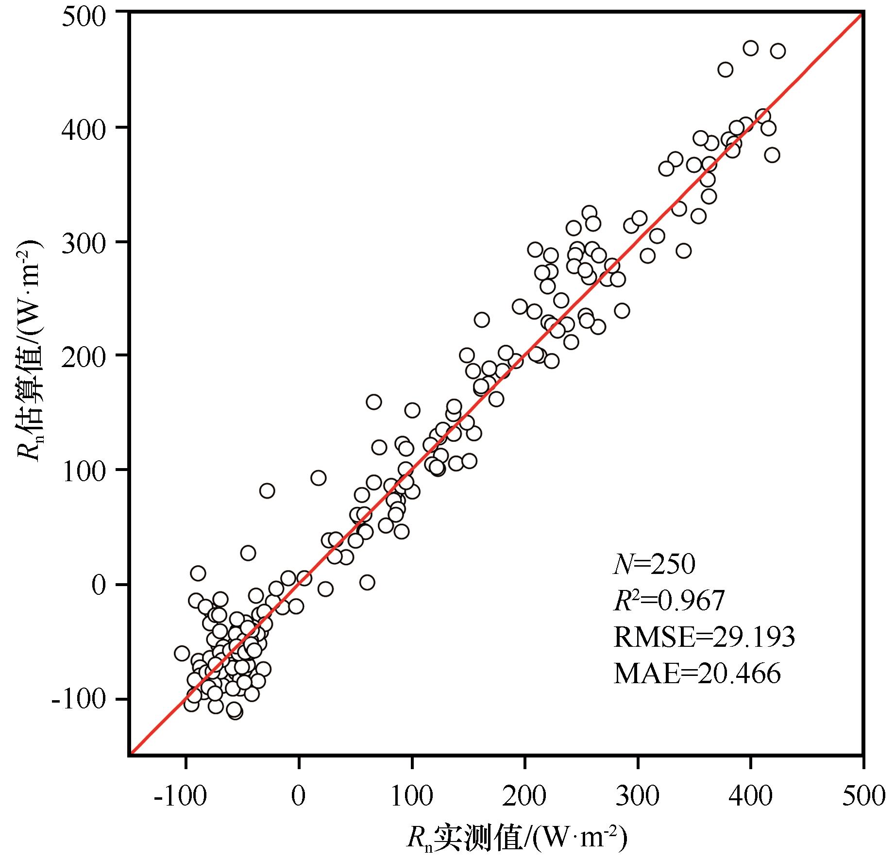
Fig.3 Comparison of observed and estimated daily net radiation in different seasons
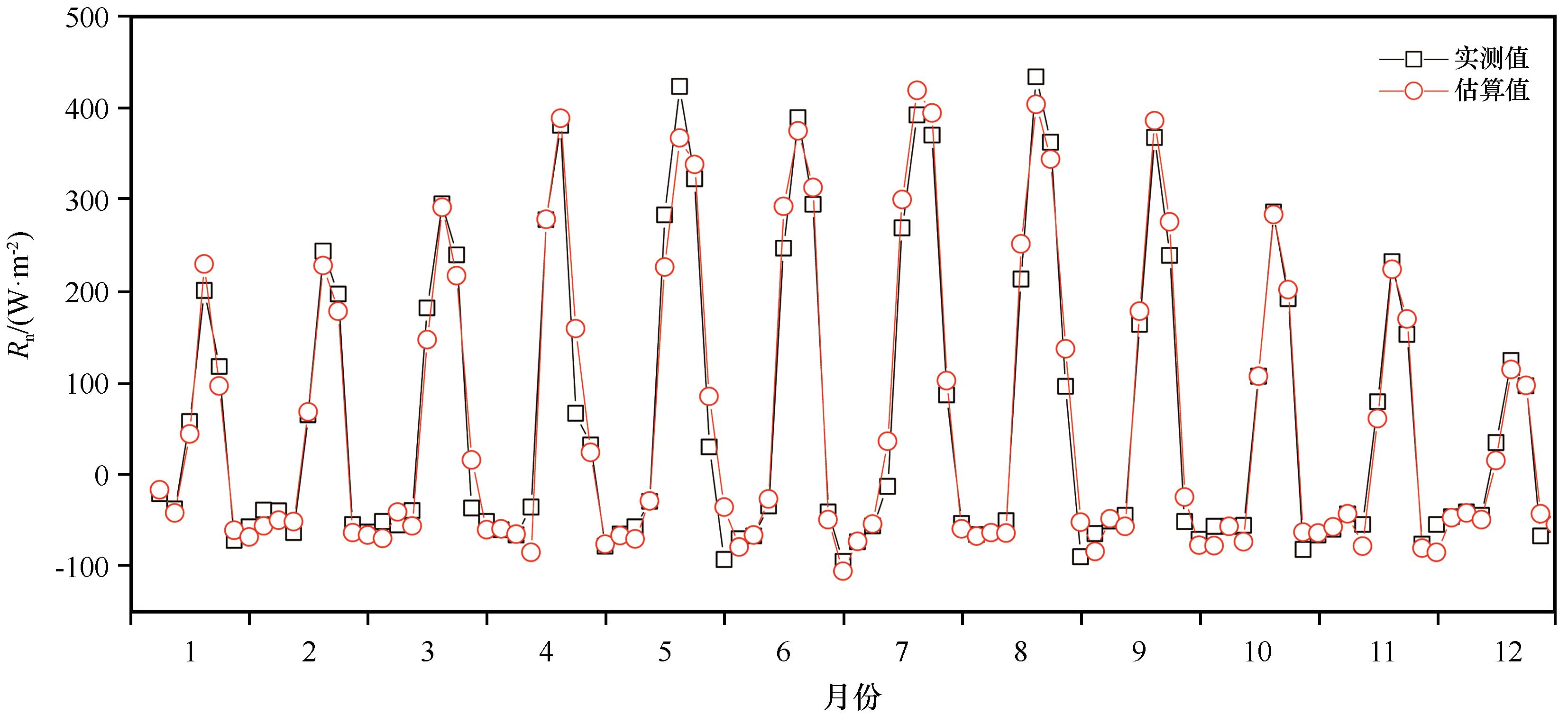
Fig.4 Comparison of the diurnal variation of net radiation between observed and estimated net radiation in different months
| 月份 | R2 | MAE | RMSE | EF |
|---|---|---|---|---|
| 1 | 0.960 | 17.407 | 22.590 | 0.951 |
| 2 | 0.979 | 13.750 | 18.697 | 0.978 |
| 3 | 0.918 | 31.984 | 40.148 | 0.924 |
| 4 | 0.948 | 20.431 | 37.229 | 0.947 |
| 5 | 0.959 | 28.351 | 40.586 | 0.944 |
| 6 | 0.978 | 21.368 | 26.960 | 0.997 |
| 7 | 0.979 | 22.134 | 33.385 | 0.967 |
| 8 | 0.970 | 26.589 | 33.848 | 0.967 |
| 9 | 0.981 | 21.024 | 28.405 | 0.971 |
| 10 | 0.975 | 17.863 | 23.266 | 0.975 |
| 11 | 0.949 | 23.385 | 29.695 | 0.936 |
| 12 | 0.922 | 12.998 | 23.176 | 0.901 |
Table 5 The precision inspection results of daily net radiation in 2017
| 月份 | R2 | MAE | RMSE | EF |
|---|---|---|---|---|
| 1 | 0.960 | 17.407 | 22.590 | 0.951 |
| 2 | 0.979 | 13.750 | 18.697 | 0.978 |
| 3 | 0.918 | 31.984 | 40.148 | 0.924 |
| 4 | 0.948 | 20.431 | 37.229 | 0.947 |
| 5 | 0.959 | 28.351 | 40.586 | 0.944 |
| 6 | 0.978 | 21.368 | 26.960 | 0.997 |
| 7 | 0.979 | 22.134 | 33.385 | 0.967 |
| 8 | 0.970 | 26.589 | 33.848 | 0.967 |
| 9 | 0.981 | 21.024 | 28.405 | 0.971 |
| 10 | 0.975 | 17.863 | 23.266 | 0.975 |
| 11 | 0.949 | 23.385 | 29.695 | 0.936 |
| 12 | 0.922 | 12.998 | 23.176 | 0.901 |
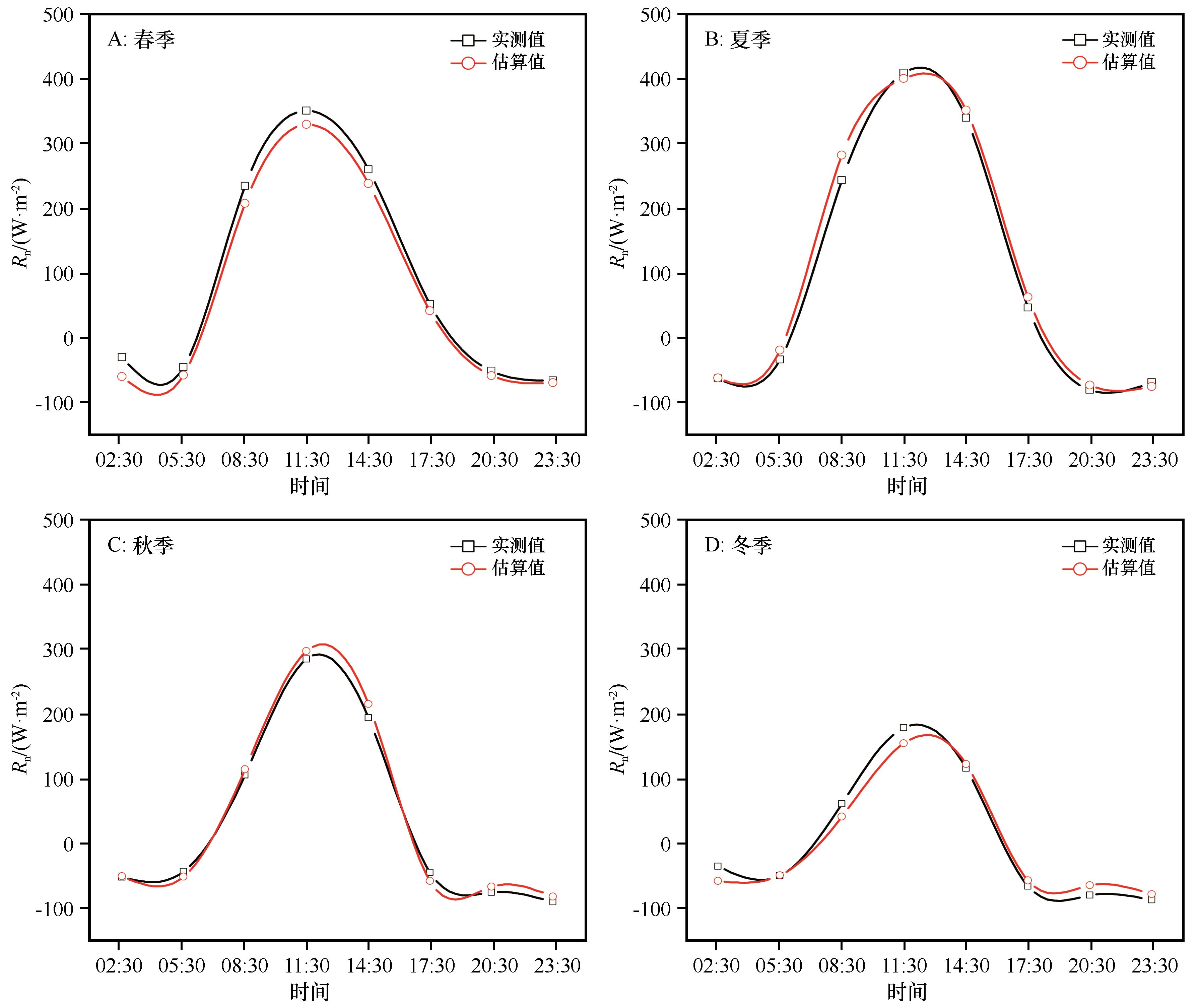
Fig.5 Comparison of diurnal variation of net radiation between observed and estimated net radiation in different seasons
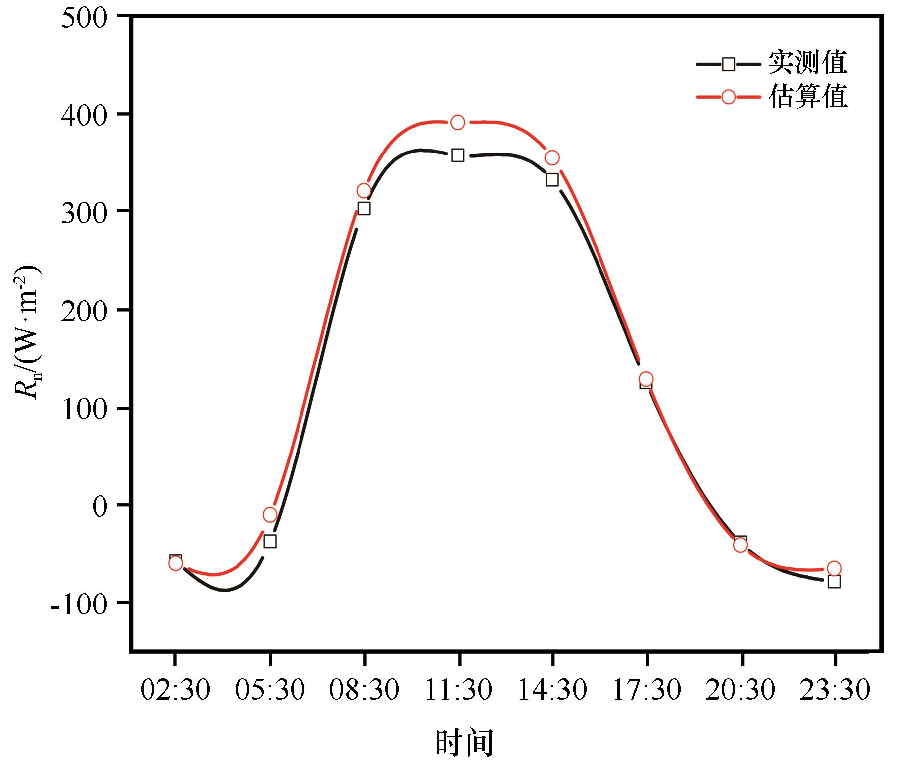
Fig.6 The diurnal variations of daily net radiation on July 8, 2017
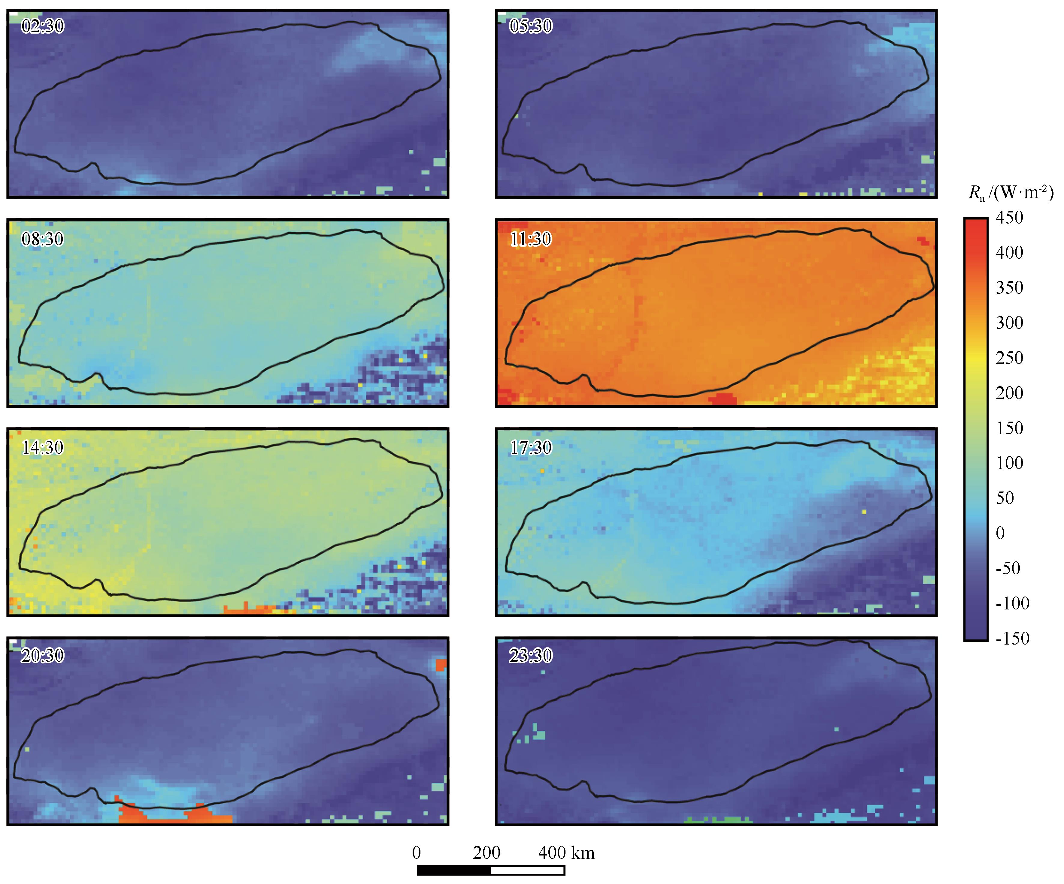
Fig.7 The distribution of net radiation on July 8, 2017
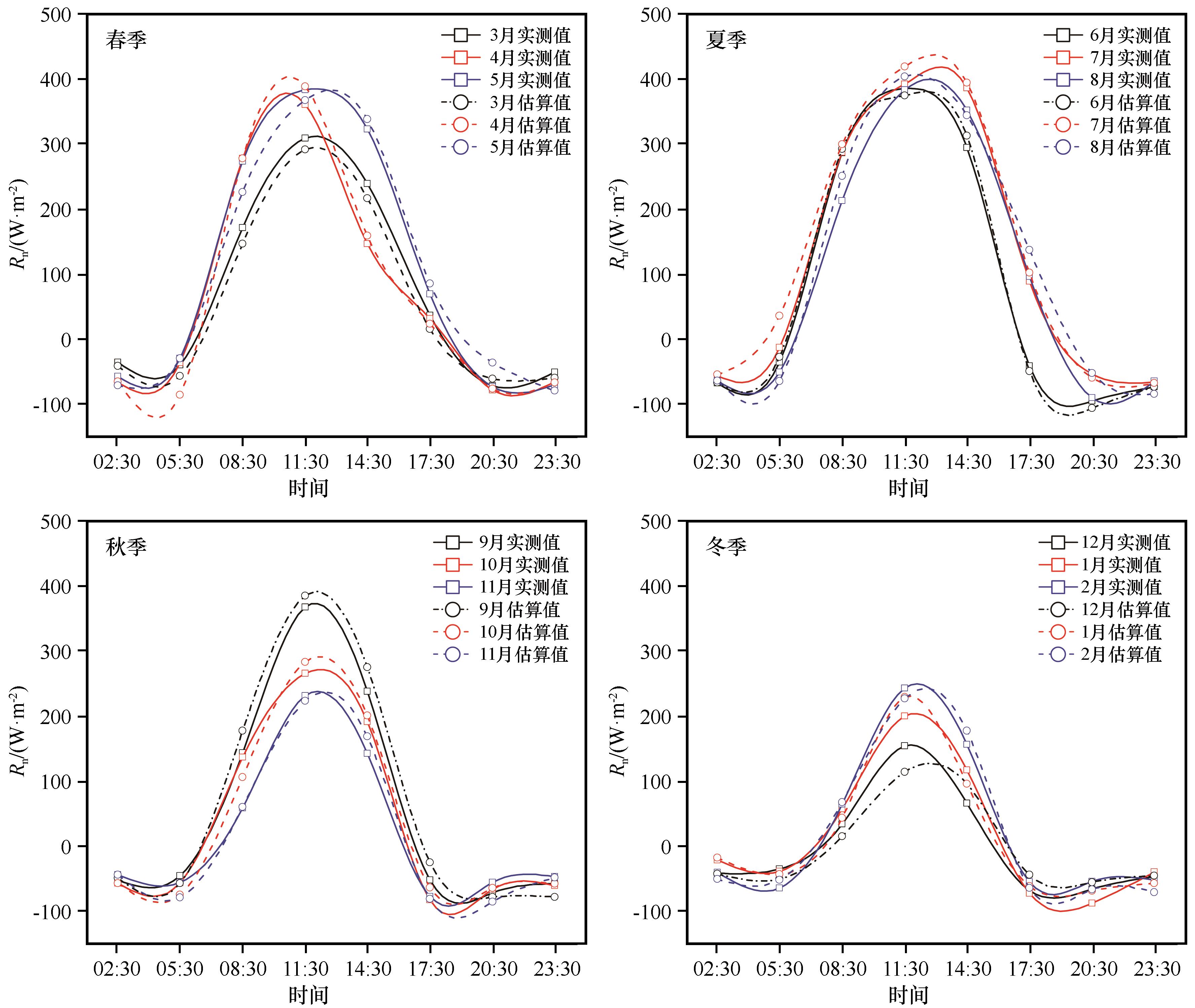
Fig.8 The diurnal variation of net radiation in different season
| 1 | 延芳芳.陆地生态系统碳通量观测方法的研究进展[J].科技促进发展,2012():158-159. |
| 2 | 赵丽芳,沈占锋,李春明,等.地表净辐射通量观测、模拟和同化的研究进展[J].遥感学报,2019,23(1):24-36. |
| 3 | 陈征,胡德勇,蒋卫国,等.基于GLASS数据估算中国陆表净辐射及其空间分布分析[J].地理研究,2016,35(1):25-36. |
| 4 | Malek E.Evaluation of effective atmospheric emissivity and parameterization of cloud at local scale[J].Atmospheric Research,1997,45(1):41-54. |
| 5 | Paltridge G W,Platt M R.Radiative process in meteorology and climatology[J].Social Studies of Science,2010,40(1):41-70. |
| 6 | 高扬子,何洪林,张黎,等.近50年中国地表净辐射的时空变化特征分析[J].地球信息科学学报,2013,15(1):1-10. |
| 7 | 彭丽春,李万彪,叶晶,等.地表向下短波和长波辐射遥感参数化方案研究综述[J].北京大学学报(自然科学版),2015,51(4):772-782. |
| 8 | Li Z,Zhao L,Fu Z.Estimating net radiation flux in the Tibetan Plateau by assimilating MODIS LST products with an ensemble Kalman filter and particle filter[J].International Journal of Applied Earth Observations and Geoinformation,2012,19:1-11. |
| 9 | Silva B,Montenegro S,Silva V,et al.Determination of instantaneous and daily net radiation from TM-Landsat 5 data in a subtropical watershed[J].Journal of Atmospheric and Solar-Terrestrial Physics,2015,135:42-49. |
| 10 | Wang W,Liang S.Estimation of high-spatial resolution clear-sky longwave downward and net radiation over land surfaces from MODIS data[J].Remote Sensing of Environment,2009,113(4):745-754. |
| 11 | 吴晓.从FY-4静止气象卫星估算晴空地表下行长波辐射通量的反演模式[J].气候与环境研究,2014,19(3):362-370. |
| 12 | Wang D,Liang S,He T,et al.Estimating clear-sky all-wave net radiation from combined visible and shortwave infrared (VSWIR) and thermal infrared (TIR) remote sensing data[J].Remote Sensing of Environment,2015,167:31-39. |
| 13 | 叶晶,刘辉志,李万彪,等.利用MODIS数据直接估算晴空区干旱与半干旱地表净辐射通量[J].北京大学学报(自然科学版),2010,46(6):942-950. |
| 14 | Jia A,Liang S,Jiang B,et al.Comprehensive assessment of global surface net radiation products and uncertainty analysis[J].Journal of Geophysical Research Atmospheres,2018,123(4):1970-1989. |
| 15 | Carmona F,Rivas R,Caselles V,et al.Development of a general model to estimate the instantaneous,daily,and daytime net radiation with satellite data on clear-sky days[J].Remote Sensing of Environment,2015,17:11-13. |
| 16 | Amatya P M,Ma Y,Han C,et al.Estimation of net radiation flux distribution on the southern slopes of the central Himalayas using MODIS data[J].Atmospheric Research,2015,154:146-154. |
| 17 | Hurtado E,Sobrino J A.Daily net radiation estimated from air temperature and NOAA-AVHRR data:a case study for the Iberian Peninsula[J].International Journal of Remote Sensing,2010,22(8):1521-1533. |
| 18 | 金莉莉,何清,买买提艾力·买买提依明,等.塔克拉玛干沙漠腹地辐射平衡和反照率变化特征[J].中国沙漠,2014,34(1):215-224. |
| 19 | 李帅,胡列群,何清,等.塔克拉玛干沙漠腹地地表辐射收支特征研究[J].中国沙漠,2012,32(4):1035-1044. |
| 20 | 杨帆,王顺胜,何清,等.塔克拉玛干沙漠腹地地表辐射与能量平衡[J].中国沙漠,2016,36(5):1408-1418. |
| 21 | 买买提艾力·买买提依明,金莉莉,李振杰,等.2007—2011年塔克拉玛干沙漠腹地太阳辐射观测研究[J].气候变化研究进展,2014,10(2):87-94. |
| 22 | 赵佳伟,何清,金莉莉,等.塔克拉玛干沙漠腹地秋季陆面过程特征[J].中国沙漠,2019,39(4):159-167. |
| 23 | 周洒洒,何清,金莉莉,等.塔克拉玛干沙漠北缘绿洲-荒漠过渡带辐射特征:以肖塘为例[J].中国沙漠,2020,40(4):43-51. |
| 24 | 金莉莉,李振杰,何清,等.CoLM模式对塔克拉玛干沙漠北缘陆面过程模拟评估及修正[J].中国沙漠,2018,38(6):1287-1302. |
| 25 | 刘永强,艾力·买买提明,何清.对陆面过程模型CoLM中关键参数的修正[J].干旱区研究,2014,31(4):611-618. |
| 26 | 李火青,买买提艾力·买买提依明,刘永强,等.陆面模型Noah-MP的不同参数化方案在沙漠区域的适用性研究[J].沙漠与绿洲气象,2018,12(6):58-67. |
| 27 | 孟露,赵天良,杨兴华,等.塔克拉玛干沙漠腹地大气边界层参数化方案的模拟评估[J].气象科学,2018,38(2):157-166. |
| 28 | 齐斐斐,刘永强,杨帆,等.SEBS模型在塔克拉玛干沙漠地区地表能量通量估算中的应用[J].干旱区资源与环境,2019,33(7):130-135. |
| 29 | 齐斐斐,买买提艾力·买买提依明,霍文,等.塔克拉玛干沙漠腹地地表辐射和能量平衡及小气候特征[J].干旱气象,2020,38(1):32-39. |
| 30 | 占车生,宁理科,邹靖,等.陆面水文-气候耦合模拟研究进展[J].地理学报,2018,73(5):893-905. |
| 31 | 阿依尼格尔·亚力坤,买买提艾力·买买提依明,刘素红,等.新疆沙漠地区地表宽波段比辐射率遥感估算[J].地球信息科学学报,2020,22(8):1743-1751. |
| 32 | 赵静学,郭枝虾,和鑫磊,等.黑河流域气温和降水再分析数据的不确定性评估[J].干旱气象,2019,37(4):529-539. |
| 33 | Idso S B,Jackson R D.Thermal radiation from the atmosphere[J].Journal of Geophysical Research,1969,74(23):5397-5403. |
| 34 | 阿依尼格尔·亚力坤.塔克拉玛干沙漠地表特征参数及能量通量的遥感反演研究[D].乌鲁木齐:新疆大学,2020. |
| 35 | Offerle B,Grimmond C S B,Oke T R.Parameterization of net all-wave radiation for urban areas[J].Journal of Applied Meteorology,2003,42(8):1157-1173. |
| 36 | 李火青,吴新萍,买买提艾力·买买提依明,等.利用FTIR和MODIS数据估算塔克拉玛干沙漠宽波段地表比辐射率[J].光谱学与光谱分析,2016,36(8):2414-2419. |
| 37 | Qian T,Dai A,Trenberth K E,et al.Simulation of global land surface conditions from 1948 to 2004.part I:forcing data and evaluations[J].Journal of Hydrometeorology,2006,7(5):953-975. |
| 38 | Pan X,Li X,Yang K,et al.Comparison of downscaled precipitation data over a mountainous watershed:a case study in the Heihe River Basin[J].Journal of Hydrometeorology,2014,15(4):1560-1574. |
| 39 | 陆风,张晓虎,陈博洋,等.风云四号气象卫星成像特性及其应用前景[J].海洋气象学报,2017,37(2):1-12. |
| [1] | Lei Wu, Changbin Li, Liuming Wang, Xuhong Xie, Yuan Zhang, Jianmei Wei. Division and application of desert-oasis system in arid Northwest China based on ESA-LUC and MODIS-NDVI [J]. Journal of Desert Research, 2020, 40(6): 139-150. |
| [2] | Jiantao Zhang, Minzhong Wang, Qing He, Honglin Pan, Lu Meng, Yanhui Wang. Variation characteristics of nocturnal low-level jet in summer over the hinterland of Taklimakan Desert [J]. Journal of Desert Research, 2020, 40(5): 89-100. |
| [3] | Zhao Jiawei, He Qing, Jin Lili, Li Zhenjie, Ali Mamtimin, Zhang Jiantao, Aikedai Shalamu. The surface layer micrometeorological characteristics of fluctuated surface in the hinterland of Taklimakan Desert [J]. Journal of Desert Research, 2020, 40(2): 144-155. |
| [4] | Li Aimin, Han Zhiwen. Relationship between moving speed and morphological parameters of barchan dunes [J]. Journal of Desert Research, 2020, 40(1): 29-40. |
| [5] | Jin Lili, Li Zhenjie, He Qing, Ali Mamtimin, Huo Wen, Zhang Jiantao. Characteristic of Surface-Layer Turbulence Spectra on Typical Sunny Days over the Northern Marginal Zone of the Taklimakan Desert [J]. Journal of Desert Research, 2019, 39(6): 1-12. |
| [6] | Li Zhipeng, Cao Xiaoming, Ding Jie, Feng Yiming. Annual Desertification during 2001-2017 in China Based on MODIS Satellite Images [J]. Journal of Desert Research, 2019, 39(6): 135-140. |
| [7] | Zhao Jiawei, He Qing, Jin Lili, Li Zhenjie, Ali Mamtimin, Zhang Jiantao. Characteristics of Land Surface Processes in the Hinterland of Taklimakan Desert in Autumn [J]. Journal of Desert Research, 2019, 39(4): 159-167. |
| [8] | Zhang Jiaqi, Zhang Bo, Ma Bin, Cao Bo, Liang Jingjing, Ma Shangqian. Spatial-temporal Variation of NDVI in Sanjiang Plain and Its Response to Climate Change [J]. Journal of Desert Research, 2019, 39(3): 206-213. |
| [9] | Zhou Xueying, Jia Jian, Liu Guoqiang, Wang Fang, Qiu Huimin, Sun Huaiqin. Characteristics of Precipitation at Hinterland of Taklimakan Desert, China [J]. Journal of Desert Research, 2019, 39(1): 187-194. |
| [10] | Wang Minzhong, Xu Hongxiong, Wang Yinjun, Ali Mamtimin, Zhang Jiantao. Large-Eddy Simulation of Summer Clear Sky Convective Boundary Layer in the Taklimakan Desert [J]. Journal of Desert Research, 2018, 38(6): 1275-1286. |
| [11] | Jin Lili, Li Zhenjie, He Qing, Liu Yongqiang, Ali Mamtimin, Xin Yu. Evaluation on Modeling of Land-Atmosphere Interaction in the Northern Marginal Zone of Taklimakan Desert with CoLM and Correction [J]. Journal of Desert Research, 2018, 38(6): 1287-1302. |
| [12] | Li Aimin, Han Zhiwen, Zhong Shuai, Guo Caiyun. Attributive Parameter Extraction of the Barchan Dune Based on CASS and ArcGIS [J]. Journal of Desert Research, 2018, 38(3): 484-491. |
| [13] | Reyilai Kadeer, Yusufu Maimaiti, Yusufujiang Rusuli, Adilai Wufu, Aizezitiyuemaier Maimaiti, Jiang Hong. Spatio-temporal Variation of Land Surface Temperature in the Ili River Valley during 2001-2014 [J]. Journal of Desert Research, 2018, 38(3): 637-644. |
| [14] | Peng Yanmei, Wang Shu, Xiao Gaoxiang, Gao Lei, He Qing, Liu Xinchun. Impact Factors of Atmospheric Aerosol Scattering Coefficient in the Tazhong Area of the Taklimakan Desert [J]. JOURNAL OF DESERT RESEARCH, 2018, 38(2): 384-392. |
| [15] | Liao Xiaohe, He Qing, Jin Lili, Yang Xinghua, Ali Mamtimin, Huo Wen, Yang Fan. Change of Surface Albedo, Soil Temperature and Moisture under Snow Cover in the Hinterland of Taklimakan Desert in Winter [J]. JOURNAL OF DESERT RESEARCH, 2018, 38(2): 393-400. |
| Viewed | ||||||
|
Full text |
|
|||||
|
Abstract |
|
|||||
©2018Journal of Desert Research
Tel:0931-8267545
Email:caiedit@lzb.ac.cn;desert@lzb.ac.cn
Support:Magtech