
- CN 62-1070/P
- ISSN 1000-694X
- Bimonthly 1981
Journal of Desert Research ›› 2023, Vol. 43 ›› Issue (1): 27-36.DOI: 10.7522/j.issn.1000-694X.2022.00070
Previous Articles Next Articles
Xinyue Zhao1,2( ), Haiyang Xi1(), Jing Zhao3, Kehua Ma3, Wenju Cheng1,2, Yuqing Chen1,2
Received:2022-04-01
Revised:2022-06-10
Online:2023-01-20
Published:2023-01-17
Contact:
Haiyang Xi
CLC Number:
Xinyue Zhao, Haiyang Xi, Jing Zhao, Kehua Ma, Wenju Cheng, Yuqing Chen. Inversion and spatial distribution characteristics of soil salinity in Alxa area, China[J]. Journal of Desert Research, 2023, 43(1): 27-36.
Add to citation manager EndNote|Ris|BibTeX
URL: http://www.desert.ac.cn/EN/10.7522/j.issn.1000-694X.2022.00070
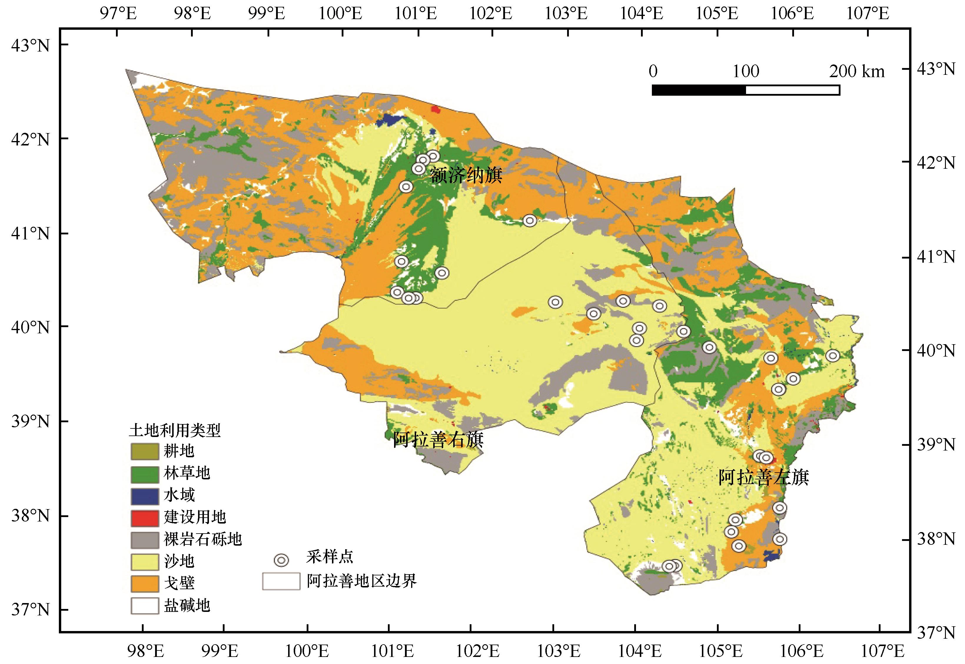
Fig.1 Study area and distribution of sampling points
| 光谱指数 | 公式 | 参考文献 |
|---|---|---|
| 盐分指数 (SI-T) | SI-T =Red/NIR×100 | [ |
| 盐分指数 (SI) | SI = | [ |
| 盐分指数 (SI1) | SI1 = | [ |
| 盐分指数 (SI2) | SI2 = | [ |
| 盐分指数 (SI3) | SI3= | [ |
| 盐分指数 (SI4) | SI4 =SWIR1/NIR | [ |
| 盐分指数 (SI5) | SI5= (Red-SWIR1)/(Red +SWIR1) | [ |
| 盐分指数 (SI6) | SI6 =Blue×Red/Green | [ |
| 盐分指数 (SI7) | SI7 =Red×NIR/Green | [ |
| 亮度指数 (BI) | BI= | [ |
| 归一化盐分指数 (NDSI) | NDSI=(Red-NIR)/(Red +NIR) | [ |
| 土壤条件植被指数 (SAVI) | SAVI = (NIR-Red)×1.5/(NIR+Red+0.5) | [ |
| 归一化植被指数 (NDVI) | NDVI = (NIR-Red)/(NIR +Red) | [ |
| 差值植被指数 (DVI) | DVI =NIR-Red | [ |
| 比值植被指数 (RVI) | RVI =NIR/Red | [ |
| 盐渍化遥感指数 (SRSI) | SRSI = | [ |
Table 1 Calculation formula of spectral index
| 光谱指数 | 公式 | 参考文献 |
|---|---|---|
| 盐分指数 (SI-T) | SI-T =Red/NIR×100 | [ |
| 盐分指数 (SI) | SI = | [ |
| 盐分指数 (SI1) | SI1 = | [ |
| 盐分指数 (SI2) | SI2 = | [ |
| 盐分指数 (SI3) | SI3= | [ |
| 盐分指数 (SI4) | SI4 =SWIR1/NIR | [ |
| 盐分指数 (SI5) | SI5= (Red-SWIR1)/(Red +SWIR1) | [ |
| 盐分指数 (SI6) | SI6 =Blue×Red/Green | [ |
| 盐分指数 (SI7) | SI7 =Red×NIR/Green | [ |
| 亮度指数 (BI) | BI= | [ |
| 归一化盐分指数 (NDSI) | NDSI=(Red-NIR)/(Red +NIR) | [ |
| 土壤条件植被指数 (SAVI) | SAVI = (NIR-Red)×1.5/(NIR+Red+0.5) | [ |
| 归一化植被指数 (NDVI) | NDVI = (NIR-Red)/(NIR +Red) | [ |
| 差值植被指数 (DVI) | DVI =NIR-Red | [ |
| 比值植被指数 (RVI) | RVI =NIR/Red | [ |
| 盐渍化遥感指数 (SRSI) | SRSI = | [ |
| 年份 | 样本数/个 | 最小值/(g·kg-1) | 最大值/(g·kg-1) | 平均值/(g·kg-1) | 标准差/(g·kg-1) | 变异系数CV |
|---|---|---|---|---|---|---|
| 2018 | 34 | 0.28 | 42.47 | 2.53 | 7.32 | 2.90 |
| 2019 | 34 | 0.24 | 41.75 | 2.92 | 8.30 | 2.84 |
Table 2 Statistical characteristics of soil salinity in soil samples
| 年份 | 样本数/个 | 最小值/(g·kg-1) | 最大值/(g·kg-1) | 平均值/(g·kg-1) | 标准差/(g·kg-1) | 变异系数CV |
|---|---|---|---|---|---|---|
| 2018 | 34 | 0.28 | 42.47 | 2.53 | 7.32 | 2.90 |
| 2019 | 34 | 0.24 | 41.75 | 2.92 | 8.30 | 2.84 |
| 波段 | 相关系数 |
|---|---|
| 蓝Blue | -0.200 |
| 绿Green | -0.189 |
| 红Red | -0.287 |
| 近红外NIR | 0.082 |
| 短波红外SWIR1 | 0.128 |
| 短波红外SWIR2 | -0.442* |
Table 3 Correlation coefficient between band reflectance and salt content
| 波段 | 相关系数 |
|---|---|
| 蓝Blue | -0.200 |
| 绿Green | -0.189 |
| 红Red | -0.287 |
| 近红外NIR | 0.082 |
| 短波红外SWIR1 | 0.128 |
| 短波红外SWIR2 | -0.442* |
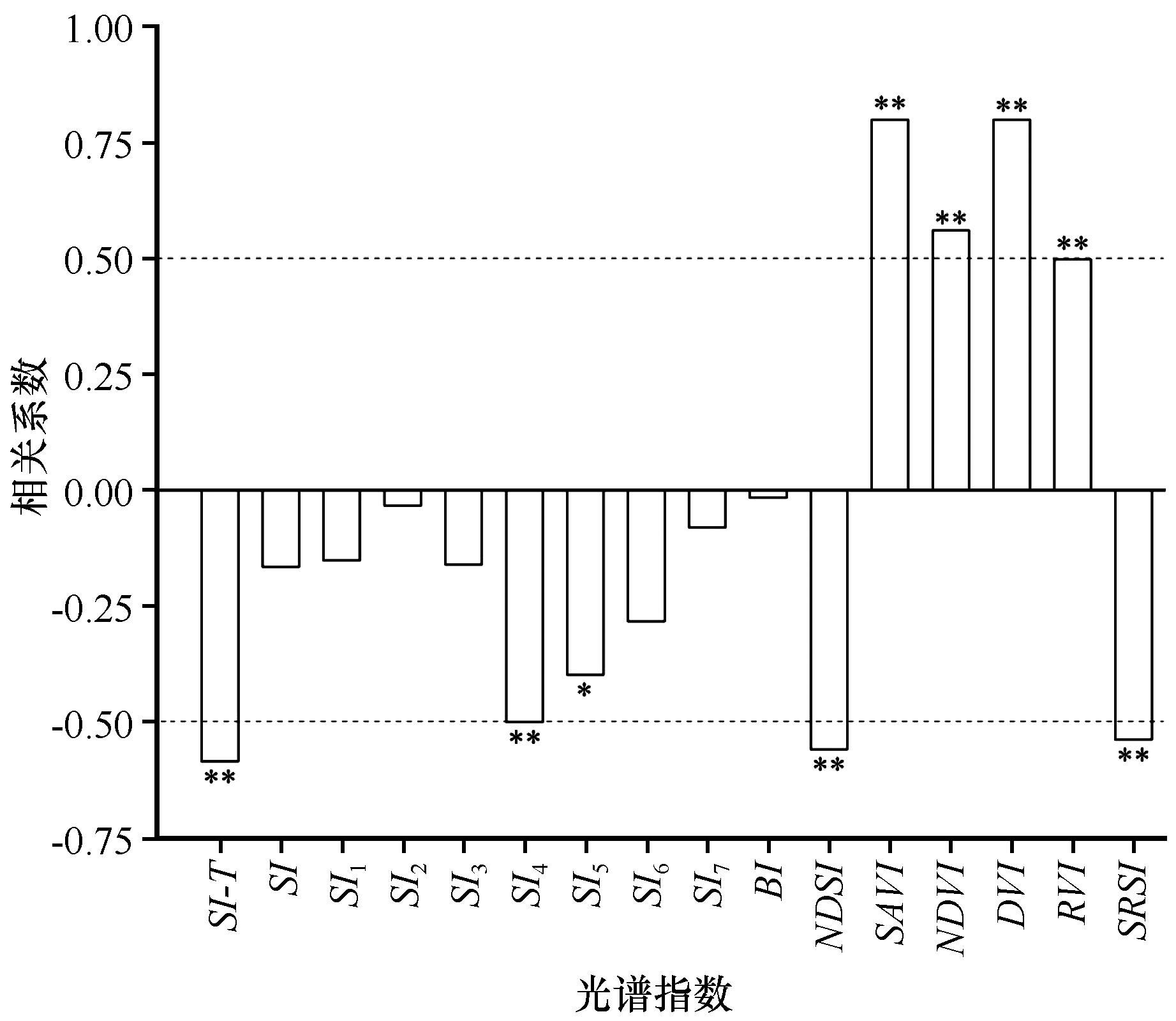
Fig.2 Correlation coefficient between soil salt content and spectral index in the study area (* P<0.05; ** P<0.01)
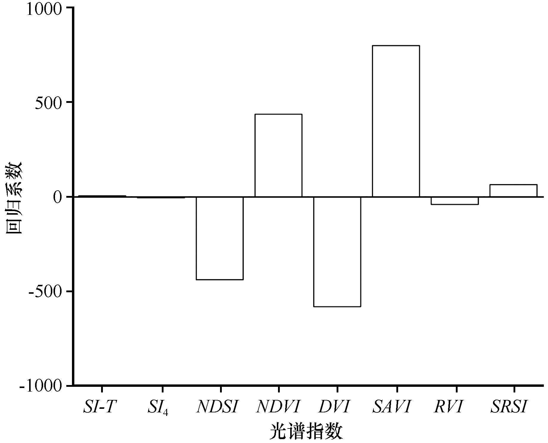
Fig.3 Regression coefficients of PLSR model with 8 latent variables

Fig.4 Soil salinity inversion accuracy of PLSR model calibration set and validation set in 2019
| 建模集 | 验证集 | ||||
|---|---|---|---|---|---|
| 决定系数R2 | 均方根误差RMSE | 决定系数R2 | 均方根误差RMSE | 相对分析误差RPD | |
| 0.9771 | 0.7172 | 0.9242 | 1.3472 | 2.8724 | |
Table 4 Soil salinity inversion accuracy of PLSR model
| 建模集 | 验证集 | ||||
|---|---|---|---|---|---|
| 决定系数R2 | 均方根误差RMSE | 决定系数R2 | 均方根误差RMSE | 相对分析误差RPD | |
| 0.9771 | 0.7172 | 0.9242 | 1.3472 | 2.8724 | |
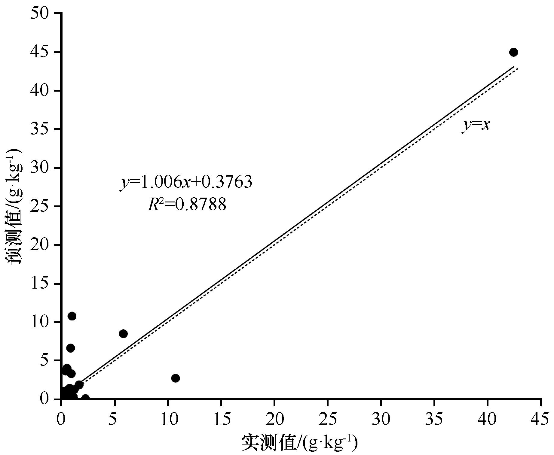
Fig.5 Soil salinity inversion accuracy of PLSR model in 2018
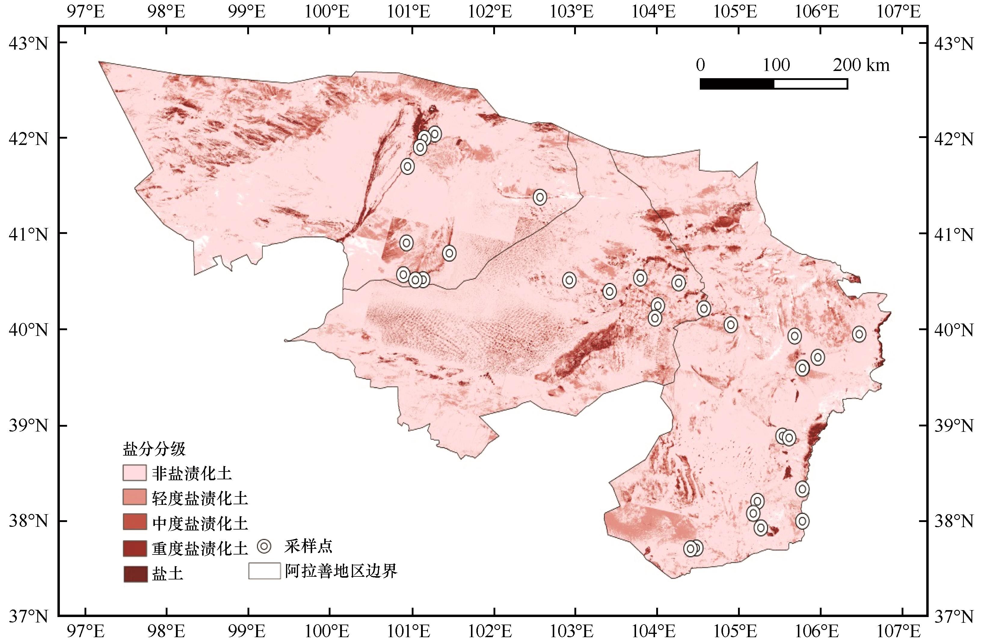
Fig.6 Spatial distribution of soil salinity in the study area in 2019
| 1 | Metternicht G I, Zinck J A.Remote sensing of soil salinity:potentials and constraints[J].Remote Sensing of Environment,2003,85(1):1-20. |
| 2 | Gorji T, Sertel E, Tanik A.Monitoring soil salinity via remote sensing technology under data scarce conditions:a case study from Turkey[J].Ecological Indicators,2017,74:384-391. |
| 3 | 丁建丽,姚远,王飞.干旱区土壤盐渍化特征空间建模[J].生态学报,2014,34(16):4620-4631. |
| 4 | Mougenot B, Pouget M, Epema G.Remote sensing of salt-affected soils[J].Remote Sensing Reviews,1993,7(3/4):241-259. |
| 5 | 张飞,塔西甫拉提·特依拜,丁建丽,等.渭干河-库车河三角洲绿洲土壤盐渍化现状特征及其与光谱的关系[J].环境科学研究,2009,22(2):227-235. |
| 6 | 翁永玲,戚浩平,方洪宾,等.基于PLSR方法的青海茶卡-共和盆地土壤盐分高光谱遥感反演[J].土壤学报,2010,47(6):1255-1263. |
| 7 | Farifteh J, Van der Meer F, Atzberger C,et al.Quantitative analysis of salt-affected soil reflectance spectra:a comparison of two adaptive methods (PLSR and ANN)[J].Remote Sensing of Environment,2007,110(1):59-78. |
| 8 | 扶卿华,倪绍祥,王世新,等.土壤盐分含量的遥感反演研究[J].农业工程学报,2007(1):48-54. |
| 9 | Vermeulen D, Van Niekerk A.Machine learning performance for predicting soil salinity using different combinations of geomorphometric covariates[J].Geoderma,2017,299:1-12. |
| 10 | 张智韬,魏广飞,姚志华,等.基于无人机多光谱遥感的土壤含盐量反演模型研究[J].农业机械学报,2019,50(12):151-160. |
| 11 | 姜红,玉素甫江•如素力,热伊莱•卡得尔,等.基于神经网络模型的干旱区绿洲土壤盐渍化评价分析[J].地球信息科学学报,2017,19(7):983-993. |
| 12 | Rodriguez-Galiano V F, Chica-Olmo M, Abarca-Hernandez F,et al.Random forest classification of mediterranean land cover using multi-seasonal imagery and multi-seasonal texture[J].Remote Sensing of Environment,2012,121:93-107. |
| 13 | 王丽爱,马昌,周旭东,等.基于随机森林回归算法的小麦叶片SPAD值遥感估算[J].农业机械学报,2015,46(1):259-265. |
| 14 | Said N, Henning B, Joachim H,et al.Modeling and mapping of soil salinity with reflectance spectroscopy and landsat data using two quantitative methods (PLSR and MARS) [J].Remote Sensing,2014,6:10813-10834. |
| 15 | Yu H, Liu M, Du B,et al.Mapping soil salinity/sodicity by using Landsat OLI imagery and PLSR algorithm over semiarid west Jilin Province,China[J].Sensors,2018,18(4):1-17. |
| 16 | Fourati H T, Bouaziz M, Benzina M,et al.Modeling of soil salinity within a semi-arid region using spectral analysis[J].Arabian Journal of Geosciences,2015,8(12):11175-11182. |
| 17 | 屈永华,段小亮,高鸿永,等.内蒙古河套灌区土壤盐分光谱定量分析研究[J].光谱学与光谱分析,2009,29(5):1362-1366. |
| 18 | 张子璇,宋雨桐,张惠中,等.水文气候影响下黄河三角洲土壤盐分时空动态[J].应用生态学报,2021,32(4):1393-1405. |
| 19 | 卢周扬帆,许端阳,张绪教,等.阿拉善干旱荒漠区土地利用变化对生态系统服务的影响[J].水土保持研究,2019,26(6):296-302. |
| 20 | 万炜,颜长珍.阿拉善高原生态环境退化研究进展[J].地球环境学报,2018,9(2):109-122. |
| 21 | 鲍士旦.土壤农化分析[M].北京:中国农业出版社,2000:178-199. |
| 22 | 杨晓潇.天津市滨海新区土壤盐分反演及土壤质量评价[D].北京:北京林业大学,2019. |
| 23 | Yu H, Liu M, Du B,et al.Analysis of salinization dynamics by remote sensing in Hetao Irrigation District of North China[J].Agricultural Water Management,2010,97(12):1952-1960. |
| 24 | Chavez P S, Berlin G L, Sowers L B.Statistical method for selecting Landsat MSS ratios[J].Journal of Applied Photographic Engineering,1982,8(1):23-30. |
| 25 | Allbed A, Kumar L, Aldakheel Y Y.Assessing soil salinity using soil salinity and vegetation indices derived from IKONOS high-spatial resolution imageries:applications in a date palm dominated region[J].Geoderma,2014,230/231(7):1-8. |
| 26 | Douaoui A E K, Nicolas H, Walter C.Detecting salinity hazards within a semiarid context by means of combining soil and remote-sensing data[J].Geoderma,2006,134(1/2):217-230. |
| 27 | Bannari A, Guedon A M, El-Harti A,et al.Characterization of slightly and moderately saline and sodic soils in irrigated agricultural land using simulated data of advanced land imaging (EO-1) sensor[J].Communications in Soil Science and Plant Analysis,2008,39(19/20):2795-2811. |
| 28 | Abbas A, Khan S, Hussain N,et al.Characterizing soil salinity in irrigated agriculture using a remote sensing approach[J].Physics and Chemistry of the Earth,2013,55/57:43-52. |
| 29 | Khan N M, Rastoskuev V V, Sato Y,et al.Assessment of hydrosaline land degradation by using a simple approach of remote sensing indicators[J].Agricultural Water Management,2005,77(1/3):96-109. |
| 30 | Huete A R.A soil-adjusted vegetation index (SAVI)[J].Remote Sensing of Environment,1988,25(3):295-309. |
| 31 | Rouse J W, Hass R W, Schell J A,et al.Monitoring the vernal advancement and retrogradation (green wave effect) of natural vegetation[R].Greenbelt,MD,USA:NASA/GSFC Type III,1974. |
| 32 | Bannari A, Morin D, Bonn F,et al.A review of vegetation indices[J].Remote Sensing Reviews,1995,13(1/2):95-120. |
| 33 | Alhammad M S, Glenn E P.Detecting date palm trees health and vegetation greenness change on the eastern coast of the United Arab Emirates using SAVI[J].International Journal of Remote Sensing,2008,29(6):1745-1765. |
| 34 | 代希君,彭杰,张艳丽,等.基于光谱分类的土壤盐分含量预测[J].土壤学报,2016,53(4):909-918. |
| 35 | 杨小虎,罗艳琴,杨海昌,等.玛纳斯河流域绿洲农田土壤盐分反演及空间分布特征[J].干旱区资源与环境,2021,35(2):156-161. |
| 36 | Bui E N, Henderson B L.Vegetation indicators of salinity in northern Queensland[J].Austral Ecology,2003,28(5):539-552. |
| 37 | 邱元霖,陈策,韩佳,等.植被覆盖条件下的解放闸灌域土壤盐分卫星遥感估算模型[J].节水灌溉,2019(10):108-112. |
| 38 | 贾艳红,赵传燕,南忠仁.黑河下游地下水波动带土壤盐分空间变异特征分析[J].干旱区地理,2008(3):379-388. |
| 39 | 吴亚坤,李金彪,高昊辰,等.阿拉善左旗土壤盐分空间变异特征研究[J].土壤,2019,51(5):1030-1035. |
| 40 | 温利强.我国盐渍土的成因及分布特征[D].合肥:合肥工业大学,2010. |
| 41 | 王遵亲,祝寿泉,俞仁培,等.中国盐渍土[M].北京:科学出版社,1993. |
| 42 | 肖生春,肖洪浪.黑河流域绿洲环境演变因素研究[J].中国沙漠,2003,23(4):51-56. |
| 43 | 张诚.阿拉善沙漠风积砂重矿物组成及物源分析[D].兰州:兰州大学,2020. |
| 44 | 杜秉晨曦,程勇翔,吴玲.准噶尔盆地植被与土壤盐渍化负关联性变化趋势分析[J].生态学报,2021,41(23):1-13. |
| 45 | 张义强,王瑞萍,白巧燕.内蒙古河套灌区土壤盐碱化发展变化及治理效果研究[J].灌溉排水学报,2018,37():118-122. |
| [1] | Xuan Liu, Peishan Zhao, Guanglei Gao, Yuanyuan Zhao, Guodong Ding, Wanlin Mi. Variations in phenology of Pinus sylvestris var. mongolica and the response to climate factors [J]. Journal of Desert Research, 2022, 42(2): 25-35. |
| [2] | Yang Aixia, Ding Jianli, Li Yanhong, Deng Kai, Wang Jinjie. Apparent Electronic Conductivity and Measured Spectral for Monitoring Soil salt Content in Arid Lakeside Wetland [J]. JOURNAL OF DESERT RESEARCH, 2016, 36(5): 1365-1373. |
| [3] | Yuan Ze, Ding Jianli, Niu Zengyi, Li Yanhua. Soil Salinization Monitoring in the Ebinur Lake Region at A Field Scale Based on GF-1 Image [J]. JOURNAL OF DESERT RESEARCH, 2016, 36(4): 1070-1078. |
| [4] | Peng Fei, Huang Cuihua, Liao Jie, Xue Xian, Wang Tao. Effect of Kalidium foliatum Community on Soil Salinization [J]. JOURNAL OF DESERT RESEARCH, 2015, 35(1): 90-93. |
| [5] | Pang Guojin, Wang Tao, Sun Jiahuan, Li Sen. Quantitative Analysis of Soil Salinity Content with Hyperspectra Data in Minqin, Gansu, China [J]. JOURNAL OF DESERT RESEARCH, 2014, 34(4): 1073-1079. |
| [6] | Yao Yuan, Ding Jianli, Zhang Fang, Jiang Hongnan, Lei Lei. Monitoring the Spatial Variability of Soil Salinity and Composite in Dry and Wet Seasons in North Tarim Basin monitored with Electromagnetic Induction Instruments [J]. JOURNAL OF DESERT RESEARCH, 2014, 34(3): 765-772. |
| [7] | Zhang Huaishan, Dai Lilan, Zhao Guiqin, Wang Ping, Wang Chunmei. Comparison on Rhizospheric Microenvironment of Three Salt-tolerant Plants [J]. JOURNAL OF DESERT RESEARCH, 2014, 34(1): 184-190. |
| [8] | Mamat·sawut1,2, Tashpolat·Tiyip1,2, DING Jian-li1,2, ZHANG fei1,2, SUN Qian1,2. Object-Oriented Information Extraction Method for Soil Salinization in Arid Area [J]. JOURNAL OF DESERT RESEARCH, 2013, 33(5): 1586-1592. |
| [9] | LEI Lei, TIYIP Tashpolat, DING Jian-li, JIANG Hong-nan, ZHANG Fei, YAO Yuan, KELIMU Ardak. Soil Salinization Information Extraction by Using Hyperspectral Data of HJ-1A HSI: A case study in the Oasis of Ugan & Kuqa, Xinjiang, China [J]. JOURNAL OF DESERT RESEARCH, 2013, 33(4): 1104-1109. |
| [10] | YOU Quan-gang;XUE Xian;HUANG Cui-hua. Preliminary Study on the Effects of Saline Water Irrigation on Soil Salinization in Deep Groundwater Area: A case study of Minqin oasis [J]. JOURNAL OF DESERT RESEARCH, 2011, 31(2): 302-308. |
| [11] | LI Xiao-song;LI Zeng-yuan;GAO Zhi-hai;BAI Li-na;WANG Beng-yu . Estimation of Vegetation Cover in Desertified Regions from Hyperion Imageries Using NDVI and Partial Least Squares Regression [J]. JOURNAL OF DESERT RESEARCH, 2011, 31(1): 162-167. |
| [12] | WANG Yu-gang;XIAO Du-ning;LI Yan. Dynamics of Soil Salt Accumulation in Oasis at Lower Reaches of an Inland River Basin [J]. JOURNAL OF DESERT RESEARCH, 2009, 29(4): 604-610. |
| [13] | WANG Yu-gang;XIAO Du-ning;LI Yan. Spatial and Temporal Dynamics of Oasis Soil Salinization in Upper and Middle Reaches of Sangonghe River, Northwest China [J]. JOURNAL OF DESERT RESEARCH, 2008, 28(3): 478-484. |
| Viewed | ||||||
|
Full text |
|
|||||
|
Abstract |
|
|||||
©2018Journal of Desert Research
Tel:0931-8267545
Email:caiedit@lzb.ac.cn;desert@lzb.ac.cn
Support:Magtech